Bridge Statistics for Franklin Park, Pennsylvania (PA)
Condition, Traffic, Stress, Structural Evaluation, Project Costs
- National Bridge Inventory (NBI) Statistics
- 28Number of bridges
- 167ft / 50.8mTotal length
- $5,241,000Total costs
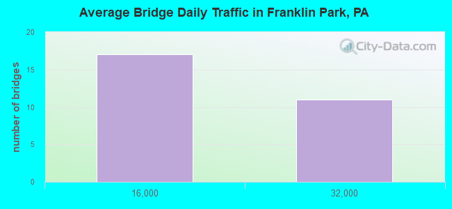
- 341,063Total average daily traffic
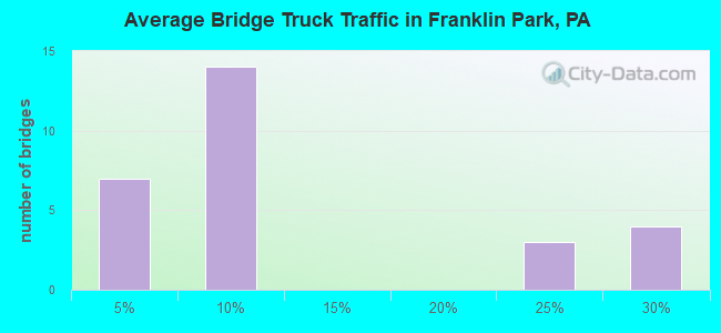
- 55,199Total average daily truck traffic
- National Bridge Inventory (NBI) Registered Bridges for Franklin Park
- No street view available for this location
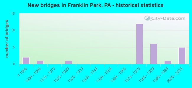
- New bridges - historical statistics
- 2Before 1900
- 11900-1909
- 11920-1929
- 121970-1979
- 61980-1989
- 11990-1999
- 52000-2009
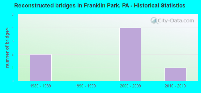
- Reconstructed bridges - Historical Statistics
- 21980-1989
- 01990-1999
- 42000-2009
- 12010-2019
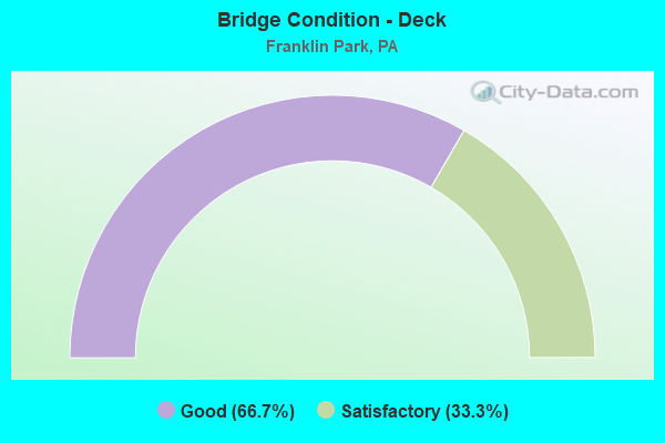
- Bridge Condition - Deck
- 66.7%Good
- 33.3%Satisfactory
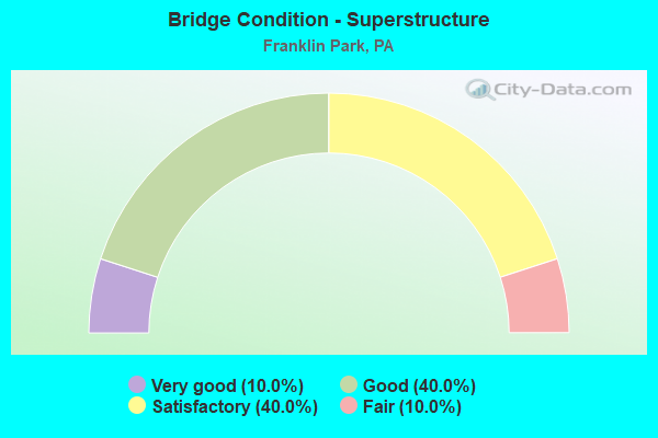
- Bridge Condition - Superstructure
- 10.0%Very good
- 40.0%Good
- 40.0%Satisfactory
- 10.0%Fair
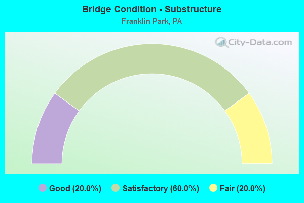
- Bridge Condition - Substructure
- 20.0%Good
- 60.0%Satisfactory
- 20.0%Fair
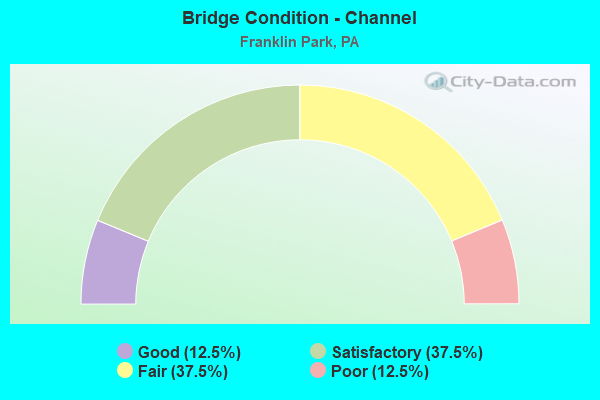
- Bridge Condition - Channel
- 12.5%Good
- 37.5%Satisfactory
- 37.5%Fair
- 12.5%Poor
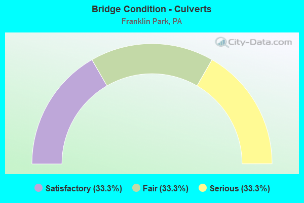
- Bridge Condition - Culverts
- 33.3%Satisfactory
- 33.3%Fair
- 33.3%Serious
Find on map >> Show street view
Structure Number: 909, Location: I-79 N.B. OVER I-279 S.B. (Lat: 40.586167, Lng: -80.100528), Route carried "on" structure: Interstate 79, Year Built: 1973, Year Reconstructed: 2008, Status: Open, Structure Length: 12.50m (41.01ft), Average Daily Traffic: 28,461 (year 2021), Truck Traffic: 23%, Average Future Daily Traffic: 19,859 (year 2032), Design Load: HS 20, Features Intersected: SR 0279 SB, Facility Carried by Structure: RAYMOND SHAFER HWY
Minimum Vertical Clearance: 30+ m (98+ ft), Kilometerpoint: 34.424, Lanes on structure: 2, Lanes under structure: 2, Base Highway Network: Yes, Owner: State Highway Agency, Approaching Roadway Width: 12.2m (40.0ft), Skew: 4 degrees, Material/Design: Steel continuous, Design/Construction: Stringer/Multi-beam, Number Of Spans In Main Unit: 4, Length of Maximum Span: 38.4m (126.0ft), Curb or Sidewalk Widths: Left: 0.2m (0.7ft), Right: 0.2m (0.7ft), Curb-To-Curb Width: 12.2m (40.0ft), Out-to-Out Width: 13.4m (44.0ft)
Condition: Deck: Satisfactory, Superstructure: Fair, Substructure: Fair, Operating Rating: 55.3 metric tons, Method Used To Determine Operating Rating: Load Factor (LF), Inventory Rating: 32.7 metric tons, Method Used To Determine Inventory Rating: Load Factor (LF), Structural Evaluation: Somewhat better than minimum adequacy, Deck Geometry: Better than present minimum criteria, Underclear: Equal to present minimum criteria, Approach Roadway Alignment: Equal to present desirable criteria, Designated Inspection Frequency: Every 24 months, Critical Feature Inspection Frequency: Every 24 months, Inspection Date: August 2021, Critical Feature Inspection Date: August 2021, Bridge Improvement Cost: $127,000, Roadway Improvement Cost: $375,000, Total Project Cost: $1,719,000, Deck Structure Type: Concrete Cast-file-Place, Wearing Surface/Protective System: Wearing Surface: Latex Concrete
Find on map >> Show street view
Structure Number: 1097, Location: 1 MI. S.E. OF SR 0079 (Lat: 40.575814, Lng: -80.093369), Route carried "on" structure: Interstate 279, Year Built: 1988, Status: Open, Structure Length: 5.06m (16.60ft), Average Daily Traffic: 25,747 (year 2021), Truck Traffic: 6%, Average Future Daily Traffic: 19,444 (year 2032), Design Load: HS 20, Features Intersected: MCALEER RD, Facility Carried by Structure: RAYMOND E WILT HW
Minimum Vertical Clearance: 30+ m (98+ ft), Kilometerpoint: 19.312, Lanes on structure: 2, Lanes under structure: 2, Base Highway Network: Yes, Owner: State Highway Agency, Approaching Roadway Width: 12.2m (40.0ft), Skew: 14 degrees, Material/Design: Prestressed concrete, Design/Construction: Stringer/Multi-beam, Number Of Spans In Main Unit: 3, Length of Maximum Span: 23.8m (78.1ft), Curb or Sidewalk Widths: Left: 0.2m (0.7ft), Right: 0.2m (0.7ft), Curb-To-Curb Width: 12.8m (42.0ft), Out-to-Out Width: 14.6m (47.9ft)
Condition: Deck: Satisfactory, Superstructure: Good, Substructure: Satisfactory, Operating Rating: 79.8 metric tons, Method Used To Determine Operating Rating: Load Factor (LF), Inventory Rating: 39.9 metric tons, Method Used To Determine Inventory Rating: Load Factor (LF), Structural Evaluation: Equal to present minimum criteria, Deck Geometry: Equal to present desirable criteria, Underclear: Equal to present minimum criteria, Approach Roadway Alignment: Equal to present desirable criteria, Length Of Structure Improvement: 5.10m (16.73ft), Designated Inspection Frequency: Every 24 months, Inspection Date: April 2020, Deck Structure Type: Concrete Cast-file-Place, Wearing Surface/Protective System: Wearing Surface: Monolithic Concrete, Deck Protection: Epoxy Coated Reinforcing
Find on map >> Show street view
Structure Number: 1984, Location: SR 910 OVER I-79 (Lat: 40.615319, Lng: -80.095456), Route carried "on" structure: State highway , Year Built: 1972, Year Reconstructed: 2009, Status: Open, Structure Length: 6.22m (20.41ft), Average Daily Traffic: 3,668 (year 2021), Truck Traffic: 2%, Average Future Daily Traffic: 10,412 (year 2032), Design Load: HS 20, Features Intersected: SR 0079 NB SB, Facility Carried by Structure: BAYNE WEXFORD ROAD
Minimum Vertical Clearance: 30+ m (98+ ft), Kilometerpoint: 2.446, Lanes on structure: 4, Lanes under structure: 12, Owner: State Highway Agency, Approaching Roadway Width: 27.4m (89.9ft), Skew: 21 degrees, Material/Design: Steel continuous, Design/Construction: Stringer/Multi-beam, Number Of Spans In Main Unit: 2, Length of Maximum Span: 30.8m (101.0ft), Curb or Sidewalk Widths: Left: 0.2m (0.7ft), Right: 0.2m (0.7ft), Curb-To-Curb Width: 25.6m (84.0ft), Out-to-Out Width: 26.8m (87.9ft)
Condition: Deck: Good, Superstructure: Satisfactory, Substructure: Satisfactory, Operating Rating: 64.4 metric tons, Method Used To Determine Operating Rating: Load Factor (LF), Inventory Rating: 38.1 metric tons, Method Used To Determine Inventory Rating: Load Factor (LF), Structural Evaluation: Equal to present minimum criteria, Deck Geometry: Superior to present desirable criteria, Underclear: Somewhat better than minimum adequacy, Approach Roadway Alignment: Equal to present desirable criteria, Length Of Structure Improvement: 6.20m (20.34ft), Designated Inspection Frequency: Every 24 months, Inspection Date: June 2020, Bridge Improvement Cost: $121,000, Roadway Improvement Cost: $356,000, Total Project Cost: $1,631,000, Deck Structure Type: Concrete Cast-file-Place, Wearing Surface/Protective System: Wearing Surface: Monolithic Concrete, Deck Protection: Epoxy Coated Reinforcing
Find on map >> Show street view
Structure Number: 1988, Location: @ INTERSECTION W/SR 4040 (Lat: 40.607503, Lng: -80.132450), Route carried "on" structure: State highway , Year Built: 1926, Year Reconstructed: 2009, Status: Open, Structure Length: 0.70m (2.30ft), Average Daily Traffic: 6,118 (year 2022), Truck Traffic: 3%, Average Future Daily Traffic: 5,590 (year 2032), Design Load: HS 20, Features Intersected: BR.BIG SEWICKLEY CREEK, Facility Carried by Structure: BIG SEWICKLEY C RD
Minimum Vertical Clearance: 30+ m (98+ ft), Kilometerpoint: 4.321, Lanes on structure: 2, Owner: State Highway Agency, Approaching Roadway Width: 8.5m (27.9ft), Material/Design: Concrete, Design/Construction: Slab, Number Of Spans In Main Unit: 1, Length of Maximum Span: 6.1m (20.0ft), Curb-To-Curb Width: 8.2m (26.9ft), Out-to-Out Width: 9.9m (32.5ft)
Condition: Deck: Good, Superstructure: Good, Substructure: Good, Channel: Good, Operating Rating: 68.0 metric tons, Method Used To Determine Operating Rating: Load Factor (LF), Inventory Rating: 40.8 metric tons, Method Used To Determine Inventory Rating: Load Factor (LF), Structural Evaluation: Better than present minimum criteria, Deck Geometry: High priority of replacement, Waterway Adequacy: Equal to present minimum criteria, Approach Roadway Alignment: Better than present minimum criteria, Length Of Structure Improvement: 0.70m (2.30ft), Designated Inspection Frequency: Every 24 months, Inspection Date: June 2020, Bridge Improvement Cost: $19,000, Roadway Improvement Cost: $57,000, Total Project Cost: $260,000, Deck Structure Type: Concrete Cast-file-Place, Wearing Surface/Protective System: Wearing Surface: Monolithic Concrete, Deck Protection: Epoxy Coated Reinforcing
Find on map >> Show street view
Structure Number: 1989, Location: INT OF WARRENDALE-BAYNE R (Lat: 40.614131, Lng: -80.143644), Route carried "on" structure: State highway , Year Built: 1978, Year Reconstructed: 2017, Status: Open, Structure Length: 1.10m (3.61ft), Average Daily Traffic: 6,118 (year 2022), Truck Traffic: 3%, Average Future Daily Traffic: 5,590 (year 2038), Design Load: HS 20, Features Intersected: BR.BIG SEWICKLEY CREEK, Facility Carried by Structure: BIG SEWICKLEY CK R
Minimum Vertical Clearance: 30+ m (98+ ft), Kilometerpoint: 5.610, Lanes on structure: 2, Owner: State Highway Agency, Approaching Roadway Width: 9.4m (30.8ft), Skew: 3 degrees, Material/Design: Prestressed concrete, Design/Construction: Box Beam or Girders - Single/Spread, Number Of Spans In Main Unit: 1, Length of Maximum Span: 11.0m (36.1ft), Curb or Sidewalk Widths: Left: 0.2m (0.7ft), Right: 0.2m (0.7ft), Curb-To-Curb Width: 9.8m (32.2ft), Out-to-Out Width: 10.8m (35.4ft)
Condition: Deck: Good, Superstructure: Good, Substructure: Satisfactory, Channel: Satisfactory, Operating Rating: 53.5 metric tons, Method Used To Determine Operating Rating: Load Factor (LF), Inventory Rating: 23.6 metric tons, Method Used To Determine Inventory Rating: Load Factor (LF), Structural Evaluation: Somewhat better than minimum adequacy, Deck Geometry: Meets minimum limits, Waterway Adequacy: Superior to present desirable criteria, Approach Roadway Alignment: Better than present minimum criteria, Length Of Structure Improvement: 1.10m (3.61ft), Designated Inspection Frequency: Every 24 months, Inspection Date: June 2020, Deck Structure Type: Concrete Cast-file-Place, Wearing Surface/Protective System: Wearing Surface: Monolithic Concrete, Deck Protection: Epoxy Coated Reinforcing
Find on map >> Show street view
Structure Number: 1994, Location: 1/4 S.W.OF I279 (Lat: 40.583222, Lng: -80.104733), Route carried "on" structure: State highway , Year Built: 1973, Year Reconstructed: 2008, Status: Open, Structure Length: 10.00m (32.81ft), Average Daily Traffic: 3,053 (year 2021), Truck Traffic: 9%, Average Future Daily Traffic: 8,455 (year 2032), Design Load: HS 20, Features Intersected: SR 0079 NB SB, Facility Carried by Structure: NICHOLSON RD
Minimum Vertical Clearance: 30+ m (98+ ft), Kilometerpoint: 3.632, Lanes on structure: 2, Lanes under structure: 8, Owner: State Highway Agency, Approaching Roadway Width: 14.0m (45.9ft), Skew: 9 degrees, Material/Design: Steel continuous, Design/Construction: Stringer/Multi-beam, Number Of Spans In Main Unit: 4, Length of Maximum Span: 30.2m (99.1ft), Curb or Sidewalk Widths: Left: 0.2m (0.7ft), Right: 0.2m (0.7ft), Curb-To-Curb Width: 13.4m (44.0ft), Out-to-Out Width: 14.6m (47.9ft)
Condition: Deck: Satisfactory, Superstructure: Satisfactory, Substructure: Satisfactory, Operating Rating: 53.5 metric tons, Method Used To Determine Operating Rating: Load Factor (LF), Inventory Rating: 31.8 metric tons, Method Used To Determine Inventory Rating: Load Factor (LF), Structural Evaluation: Equal to present minimum criteria, Deck Geometry: Better than present minimum criteria, Underclear: Meets minimum limits, Approach Roadway Alignment: Equal to present desirable criteria, Length Of Structure Improvement: 10.00m (32.81ft), Designated Inspection Frequency: Every 24 months, Inspection Date: June 2021, Bridge Improvement Cost: $106,000, Roadway Improvement Cost: $311,000, Total Project Cost: $1,426,000, Deck Structure Type: Concrete Cast-file-Place, Wearing Surface/Protective System: Wearing Surface: Latex Concrete
Find on map >> Show street view
Structure Number: 2324, Location: SB04 BIG SEWICKLEYCR# 4 (Lat: 40.617592, Lng: -80.140964), Route carried "on" structure: Other road , Year Built: 1885, Year Reconstructed: 1992, Status: Open, Structure Length: 1.01m (3.31ft), Average Daily Traffic: 10 (year 2006), Truck Traffic: 5%, Average Future Daily Traffic: 10 (year 2028), Design Load: H 20, Features Intersected: BIG SEWICKLEY CREEK, Facility Carried by Structure: ACCESS RD
Minimum Vertical Clearance: 30+ m (98+ ft), Kilometerpoint: 0.000, Lanes on structure: 2, Owner: County Highway Agency, Approaching Roadway Width: 3.0m (9.8ft), Skew: 1 degrees, Material/Design: Steel, Design/Construction: Stringer/Multi-beam, Number Of Spans In Main Unit: 1, Length of Maximum Span: 9.8m (32.2ft), Curb-To-Curb Width: 5.6m (18.4ft), Out-to-Out Width: 5.9m (19.4ft)
Condition: Deck: Good, Superstructure: Satisfactory, Substructure: Satisfactory, Channel: Satisfactory, Operating Rating: 45.4 metric tons, Method Used To Determine Operating Rating: Load Factor (LF), Inventory Rating: 27.2 metric tons, Method Used To Determine Inventory Rating: Load Factor (LF), Structural Evaluation: Equal to present minimum criteria, Deck Geometry: Meets minimum limits, Waterway Adequacy: Equal to present desirable criteria, Approach Roadway Alignment: Equal to present minimum criteria, Length Of Structure Improvement: 1.00m (3.28ft), Designated Inspection Frequency: Every 24 months, Critical Feature Inspection Frequency: Every 24 months, Inspection Date: June 2020, Critical Feature Inspection Date: June 2020, Deck Structure Type: Concrete Cast-file-Place, Wearing Surface/Protective System: Wearing Surface: Monolithic Concrete, Deck Protection: Epoxy Coated Reinforcing
Find on map >> Show street view
Structure Number: 2325, Location: SB06 BIG SEWICKLEYCR# 6 (Lat: 40.614750, Lng: -80.142969), Route carried "on" structure: Other road , Year Built: 1900, Year Reconstructed: 1992, Status: Open, Structure Length: 0.98m (3.22ft), Average Daily Traffic: 10 (year 2006), Truck Traffic: 1%, Average Future Daily Traffic: 11 (year 2028), Design Load: H 20, Features Intersected: BIG SEWICKLEY CREEK, Facility Carried by Structure: MCCARTNEY LANE
Minimum Vertical Clearance: 30+ m (98+ ft), Kilometerpoint: 0.000, Lanes on structure: 1, Owner: County Highway Agency, Approaching Roadway Width: 3.7m (12.1ft), Skew: 2 degrees, Material/Design: Steel, Design/Construction: Girder and Floorbeam System, Number Of Spans In Main Unit: 1, Length of Maximum Span: 9.1m (29.9ft), Curb-To-Curb Width: 4.8m (15.7ft), Out-to-Out Width: 5.1m (16.7ft)
Condition: Deck: Good, Superstructure: Satisfactory, Substructure: Satisfactory, Channel: Fair, Operating Rating: 52.6 metric tons, Method Used To Determine Operating Rating: Load Factor (LF), Inventory Rating: 31.8 metric tons, Method Used To Determine Inventory Rating: Load Factor (LF), Structural Evaluation: Equal to present minimum criteria, Deck Geometry: Equal to present desirable criteria, Waterway Adequacy: Equal to present desirable criteria, Approach Roadway Alignment: Equal to present minimum criteria, Length Of Structure Improvement: 0.90m (2.95ft), Designated Inspection Frequency: Every 24 months, Critical Feature Inspection Frequency: Every 24 months, Inspection Date: June 2020, Critical Feature Inspection Date: June 2020, Bridge Improvement Cost: $3,000, Roadway Improvement Cost: $25,000, Total Project Cost: $41,000, Deck Structure Type: Concrete Cast-file-Place, Wearing Surface/Protective System: Wearing Surface: Monolithic Concrete, Deck Protection: Epoxy Coated Reinforcing
Find on map >> Show street view
Structure Number: 2727, Location: FH01 FISH RUN NO. 1 (Lat: 40.592525, Lng: -80.075522), Route carried "on" structure: County highway , Year Built: 1982, Status: Open, Structure Length: 0.64m (2.10ft), Average Daily Traffic: 3,549 (year 2005), Truck Traffic: 5%, Average Future Daily Traffic: 4,025 (year 2023), Design Load: HS 20, Features Intersected: FISH RUN, Facility Carried by Structure: BRANDT SCHOOL RD
Minimum Vertical Clearance: 30+ m (98+ ft), Kilometerpoint: 0.000, Lanes on structure: 2, Owner: County Highway Agency, Approaching Roadway Width: 9.4m (30.8ft), Skew: 2 degrees, Material/Design: Steel, Design/Construction: Culvert, Number Of Spans In Main Unit: 1, Length of Maximum Span: 6.4m (21.0ft)
Condition: Channel: Fair, Culverts: Satisfactory, Operating Rating: 74.4 metric tons, Method Used To Determine Operating Rating: Field evaluation and documented engineering judgment, Inventory Rating: 44.5 metric tons, Method Used To Determine Inventory Rating: Field evaluation and documented engineering judgment, Structural Evaluation: Equal to present minimum criteria, Waterway Adequacy: Better than present minimum criteria, Approach Roadway Alignment: Equal to present desirable criteria, Length Of Structure Improvement: 0.60m (1.97ft), Designated Inspection Frequency: Every 24 months, Inspection Date: May 2021, Bridge Improvement Cost: $7,000, Roadway Improvement Cost: $40,000, Total Project Cost: $99,000
Find on map >> Show street view
Structure Number: 2728, Location: SE01 S/BIG SEW CRK RD (Lat: 40.608183, Lng: -80.135000), Route carried "on" structure: County highway , Year Built: 1891, Status: Open, Structure Length: 0.79m (2.59ft), Average Daily Traffic: 118 (year 2019), Truck Traffic: 1%, Average Future Daily Traffic: 148 (year 2039), Features Intersected: BIG SEWICKLEY CREEK EB, Facility Carried by Structure: BROWN RD
Minimum Vertical Clearance: 30+ m (98+ ft), Kilometerpoint: 0.000, Lanes on structure: 2, Owner: County Highway Agency, Approaching Roadway Width: 4.3m (14.1ft), Material/Design: Masonry, Design/Construction: Arch - Deck, Number Of Spans In Main Unit: 1, Length of Maximum Span: 7.9m (25.9ft), Curb or Sidewalk Widths: Left: 0.1m (0.3ft), Right: 0.1m (0.3ft), Curb-To-Curb Width: 6.0m (19.7ft), Out-to-Out Width: 7.6m (24.9ft)
Condition: Superstructure: Good, Substructure: Fair, Channel: Poor, Operating Rating: 49.0 metric tons, Method Used To Determine Operating Rating: Field evaluation and documented engineering judgment, Inventory Rating: 32.7 metric tons, Method Used To Determine Inventory Rating: Field evaluation and documented engineering judgment, Structural Evaluation: Somewhat better than minimum adequacy, Deck Geometry: High priority of corrective action, Waterway Adequacy: Equal to present minimum criteria, Approach Roadway Alignment: Equal to present desirable criteria, Length Of Structure Improvement: 1.00m (3.28ft), Designated Inspection Frequency: Every 24 months, Inspection Date: March 2021, Bridge Improvement Cost: $5,000, Roadway Improvement Cost: $34,000, Total Project Cost: $65,000
Find on map >> Show street view
Structure Number: 44257, Location: NEAR I-79-I-279 JUNCTION (Lat: 40.589117, Lng: -80.098569), Route carried "on" structure: State highway , Year Built: 2007, Status: Open, Structure Length: 10.52m (34.51ft), Average Daily Traffic: 6,604 (year 2022), Truck Traffic: 7%, Average Future Daily Traffic: 6,113 (year 2032), Design Load: HS 20, Features Intersected: SR 0079 NB SB, Facility Carried by Structure: Rochester Road
Minimum Vertical Clearance: 30+ m (98+ ft), Kilometerpoint: 14.301, Lanes on structure: 2, Lanes under structure: 9, Owner: State Highway Agency, Approaching Roadway Width: 13.4m (44.0ft), Skew: 9 degrees, Material/Design: Prestressed concrete, Design/Construction: Box Beam or Girders - Single/Spread, Number Of Spans In Main Unit: 5, Length of Maximum Span: 27.4m (89.9ft), Curb-To-Curb Width: 14.0m (45.9ft), Out-to-Out Width: 14.4m (47.2ft)
Condition: Deck: Good, Superstructure: Very good, Substructure: Good, Operating Rating: 85.3 metric tons, Method Used To Determine Operating Rating: Load Factor (LF), Inventory Rating: 46.3 metric tons, Method Used To Determine Inventory Rating: Load Factor (LF), Structural Evaluation: Better than present minimum criteria, Deck Geometry: Superior to present desirable criteria, Underclear: Equal to present minimum criteria, Approach Roadway Alignment: Better than present minimum criteria, Designated Inspection Frequency: Every 48 months, Inspection Date: November 2019, Deck Structure Type: Concrete Cast-file-Place, Wearing Surface/Protective System: Wearing Surface: Monolithic Concrete, Deck Protection: Epoxy Coated Reinforcing
Find on map >> Show street view
Structure Number: 49123, Location: 226' from Wexford Road (Lat: 40.594533, Lng: -80.068856), Route carried "on" structure: City street /0, Year Built: 1992, Status: Open, Structure Length: 0.67m (2.20ft), Average Daily Traffic: 100 (year 2015), Truck Traffic: 5%, Average Future Daily Traffic: 120 (year 2035), Design Load: HS 20, Features Intersected: Fish Run, Facility Carried by Structure: Barrington Dr.
Minimum Vertical Clearance: 30+ m (98+ ft), Kilometerpoint: 0.000, Lanes on structure: 2, Owner: Town or Township Highway Agency, Approaching Roadway Width: 7.0m (23.0ft), Material/Design: Concrete, Design/Construction: Culvert, Number Of Spans In Main Unit: 2, Length of Maximum Span: 3.0m (9.8ft)
Condition: Channel: Satisfactory, Culverts: Fair, Operating Rating: 51.7 metric tons, Method Used To Determine Operating Rating: Field evaluation and documented engineering judgment, Inventory Rating: 30.8 metric tons, Method Used To Determine Inventory Rating: Field evaluation and documented engineering judgment, Structural Evaluation: Somewhat better than minimum adequacy, Waterway Adequacy: Superior to present desirable criteria, Approach Roadway Alignment: Equal to present desirable criteria, Designated Inspection Frequency: Every 24 months, Inspection Date: June 2021
Find on map >> Show street view
Structure Number: 49125, Location: 93' E from Wexford Run Rd (Lat: 40.622856, Lng: -80.079272), Route carried "on" structure: County highway /0, Year Built: 1975, Status: Open, Structure Length: 0.64m (2.10ft), Average Daily Traffic: 100 (year 2015), Truck Traffic: 5%, Average Future Daily Traffic: 200 (year 2035), Design Load: HS 20, Features Intersected: Pine Creek, Facility Carried by Structure: Summit Dr.
Minimum Vertical Clearance: 30+ m (98+ ft), Kilometerpoint: 0.000, Lanes on structure: 2, Owner: Town or Township Highway Agency, Approaching Roadway Width: 6.7m (22.0ft), Material/Design: Steel, Design/Construction: Culvert, Number Of Spans In Main Unit: 2, Length of Maximum Span: 2.7m (8.9ft)
Condition: Channel: Fair, Culverts: Serious, Operating Rating: 47.2 metric tons, Method Used To Determine Operating Rating: Field evaluation and documented engineering judgment, Inventory Rating: 28.1 metric tons, Method Used To Determine Inventory Rating: Field evaluation and documented engineering judgment, Structural Evaluation: High priority of corrective action, Waterway Adequacy: Superior to present desirable criteria, Approach Roadway Alignment: Equal to present desirable criteria, Designated Inspection Frequency: Every 24 months, Other Special Inspection Frequency: Every 6 months, Inspection Date: June 2021, Other Special Inspection Date: June 2021
Find on map >> Show street view
Structure Number: 909, Location: I-79 N.B. OVER I-279 S.B. (Lat: 40.586167, Lng: -80.100528), Route carried "under" structure: Interstate 279, Year Built: 1973, Structure Length: 0. m, Average Daily Traffic: 25,849 (year 2021), Truck Traffic: 6%, Features Intersected: SR 0279 SB, Facility Carried by Structure: RAYMOND SHAFER HWY
Minimum Vertical Clearance: 5.36m (17.59ft), Kilometerpoint: 20.799, Lanes on structure: 2, Lanes under structure: 2, Material/Design: Steel continuous, Design/Construction: Stringer/Multi-beam, Length of Maximum Span: 38.4m (126.0ft)
Find on map >> Show street view
Structure Number: 913, Location: JUST N OF WEXFORD INTERCH (Lat: 40.624894, Lng: -80.096508), Route carried "under" structure: State highway , Year Built: 1972, Structure Length: 0. m, Average Daily Traffic: 2,015 (year 2022), Truck Traffic: 6%, Features Intersected: SR 4051 MINGO RD, Facility Carried by Structure: RAYMOND SHAFER HW
Minimum Vertical Clearance: 6.35m (20.83ft), Kilometerpoint: 1.014, Lanes on structure: 3, Lanes under structure: 2, Material/Design: Prestressed concrete, Design/Construction: Stringer/Multi-beam, Length of Maximum Span: 22.3m (73.2ft)
Find on map >> Show street view
Structure Number: 914, Location: JUST N OF WEXFORD INTERCH (Lat: 40.625139, Lng: -80.096900), Route carried "under" structure: State highway , Year Built: 1972, Structure Length: 0. m, Average Daily Traffic: 2,015 (year 2022), Truck Traffic: 6%, Features Intersected: MINGO RD, Facility Carried by Structure: RAYMOND SHAFER HW
Minimum Vertical Clearance: 4.50m (14.76ft), Kilometerpoint: 1.014, Lanes on structure: 3, Lanes under structure: 2, Material/Design: Prestressed concrete, Design/Construction: Stringer/Multi-beam, Length of Maximum Span: 27.4m (89.9ft)
Find on map >> Show street view
Structure Number: 1094, Location: 350' EAST OF SR 4029 (Lat: 40.550567, Lng: -80.086456), Route carried "under" structure: State highway , Year Built: 1988, Structure Length: 0. m, Average Daily Traffic: 6,989 (year 2022), Truck Traffic: 7%, Features Intersected: MT NEBO ROAD, Facility Carried by Structure: RAYMOND E WILT HW
Minimum Vertical Clearance: 4.47m (14.67ft), Kilometerpoint: 2.445, Lanes on structure: 2, Lanes under structure: 2, Material/Design: Prestressed concrete, Design/Construction: Box Beam or Girders - Single/Spread, Length of Maximum Span: 23.5m (77.1ft)
Find on map >> Show street view
Structure Number: 1095, Location: 300' EAST OF SR 4029 (Lat: 40.548528, Lng: -80.085861), Route carried "under" structure: State highway , Year Built: 1988, Structure Length: 0. m, Average Daily Traffic: 6,989 (year 2022), Truck Traffic: 7%, Features Intersected: MT NEBO RD, Facility Carried by Structure: RAYMOND E WILT HW
Minimum Vertical Clearance: 5.64m (18.50ft), Kilometerpoint: 2.445, Lanes on structure: 2, Lanes under structure: 2, Material/Design: Prestressed concrete, Design/Construction: Box Beam or Girders - Single/Spread, Length of Maximum Span: 23.5m (77.1ft)
Find on map >> Show street view
Structure Number: 1097, Location: 1 MI. S.E. OF SR 0079 (Lat: 40.575814, Lng: -80.093369), Route carried "under" structure: State highway , Year Built: 1988, Structure Length: 0. m, Average Daily Traffic: 1,650 (year 2020), Truck Traffic: 2%, Features Intersected: MCALEER RD, Facility Carried by Structure: RAYMOND E WILT HW
Minimum Vertical Clearance: 4.42m (14.50ft), Kilometerpoint: 2.298, Lanes on structure: 2, Lanes under structure: 2, Material/Design: Prestressed concrete, Design/Construction: Stringer/Multi-beam, Length of Maximum Span: 23.8m (78.1ft)
Find on map >> Show street view
Structure Number: 1098, Location: 1 MI. S.E. OF SR 0079 (Lat: 40.575411, Lng: -80.093542), Route carried "under" structure: State highway , Year Built: 1988, Structure Length: 0. m, Average Daily Traffic: 1,650 (year 2020), Truck Traffic: 2%, Features Intersected: LR 02127-MCALEER RD., Facility Carried by Structure: RAYMOND E WILT HW
Minimum Vertical Clearance: 5.76m (18.90ft), Kilometerpoint: 2.298, Lanes on structure: 2, Lanes under structure: 2, Material/Design: Prestressed concrete, Design/Construction: Stringer/Multi-beam, Length of Maximum Span: 23.8m (78.1ft)
Find on map >> Show street view
Structure Number: 1984, Location: SR 910 OVER I-79 (Lat: 40.615319, Lng: -80.095456), Route carried "under" structure: Interstate 79, Year Built: 1972, Structure Length: 0. m, Average Daily Traffic: 25,312 (year 2020), Truck Traffic: 26%, Features Intersected: SR 0079 NB SB, Facility Carried by Structure: BAYNE WEXFORD ROAD
Minimum Vertical Clearance: 5.16m (16.93ft), Kilometerpoint: 37.660, Lanes on structure: 4, Lanes under structure: 6, Material/Design: Steel continuous, Design/Construction: Stringer/Multi-beam, Length of Maximum Span: 30.8m (101.0ft)
Find on map >> Show street view
Structure Number: 1984, Location: SR 910 OVER I-79 (Lat: 40.615319, Lng: -80.095456), Route carried "under" structure: Interstate 79, Year Built: 1972, Structure Length: 0. m, Average Daily Traffic: 26,052 (year 2020), Truck Traffic: 27%, Features Intersected: SR 0079 NB SB, Facility Carried by Structure: BAYNE WEXFORD ROAD
Minimum Vertical Clearance: 5.16m (16.93ft), Kilometerpoint: 37.512, Lanes on structure: 4, Lanes under structure: 6, Material/Design: Steel continuous, Design/Construction: Stringer/Multi-beam, Length of Maximum Span: 30.8m (101.0ft)
Find on map >> Show street view
Structure Number: 1994, Location: 1/4 S.W.OF I279 (Lat: 40.583222, Lng: -80.104733), Route carried "under" structure: Interstate 79, Year Built: 1973, Structure Length: 0. m, Average Daily Traffic: 27,465 (year 2021), Truck Traffic: 22%, Features Intersected: SR 0079 NB SB, Facility Carried by Structure: NICHOLSON RD
Minimum Vertical Clearance: 5.12m (16.80ft), Kilometerpoint: 33.524, Lanes on structure: 2, Lanes under structure: 4, Material/Design: Steel continuous, Design/Construction: Stringer/Multi-beam, Length of Maximum Span: 30.2m (99.1ft)
Find on map >> Show street view
Structure Number: 1994, Location: 1/4 S.W.OF I279 (Lat: 40.583222, Lng: -80.104733), Route carried "under" structure: Interstate 79, Year Built: 1973, Structure Length: 0. m, Average Daily Traffic: 28,461 (year 2021), Truck Traffic: 23%, Features Intersected: SR 0079 NB SB, Facility Carried by Structure: NICHOLSON RD
Minimum Vertical Clearance: 5.12m (16.80ft), Kilometerpoint: 33.621, Lanes on structure: 2, Lanes under structure: 4, Material/Design: Steel continuous, Design/Construction: Stringer/Multi-beam, Length of Maximum Span: 30.2m (99.1ft)
Find on map >> Show street view
Structure Number: 44257, Location: NEAR I-79-I-279 JUNCTION (Lat: 40.589117, Lng: -80.098569), Route carried "under" structure: Interstate 279, Year Built: 2007, Structure Length: 0. m, Average Daily Traffic: 25,849 (year 2021), Truck Traffic: 6%, Features Intersected: SR 0079 NB SB, Facility Carried by Structure: Rochester Road
Minimum Vertical Clearance: 5.79m (19.00ft), Kilometerpoint: 20.799, Lanes on structure: 2, Lanes under structure: 2, Material/Design: Prestressed concrete, Design/Construction: Box Beam or Girders - Single/Spread, Length of Maximum Span: 27.4m (89.9ft)
Find on map >> Show street view
Structure Number: 44257, Location: NEAR I-79-I-279 JUNCTION (Lat: 40.589117, Lng: -80.098569), Route carried "under" structure: Interstate 79, Year Built: 2007, Structure Length: 0. m, Average Daily Traffic: 25,312 (year 2020), Truck Traffic: 26%, Features Intersected: SR 0079 NB SB, Facility Carried by Structure: Rochester Road
Minimum Vertical Clearance: 5.49m (18.01ft), Kilometerpoint: 34.424, Lanes on structure: 2, Lanes under structure: 2, Material/Design: Prestressed concrete, Design/Construction: Box Beam or Girders - Single/Spread, Length of Maximum Span: 27.4m (89.9ft)
Find on map >> Show street view
Structure Number: 44257, Location: NEAR I-79-I-279 JUNCTION (Lat: 40.589117, Lng: -80.098569), Route carried "under" structure: Interstate 79, Year Built: 2007, Structure Length: 0. m, Average Daily Traffic: 26,052 (year 2020), Truck Traffic: 27%, Features Intersected: SR 0079 NB SB, Facility Carried by Structure: Rochester Road
Minimum Vertical Clearance: 5.79m (19.00ft), Kilometerpoint: 34.334, Lanes on structure: 2, Lanes under structure: 3, Material/Design: Prestressed concrete, Design/Construction: Box Beam or Girders - Single/Spread, Length of Maximum Span: 27.4m (89.9ft)
Find on map >> Show street view
Structure Number: 44257, Location: NEAR I-79-I-279 JUNCTION (Lat: 40.589117, Lng: -80.098569), Route carried "under" structure: Interstate 279, Year Built: 2007, Structure Length: 0. m, Average Daily Traffic: 25,747 (year 2021), Truck Traffic: 6%, Features Intersected: SR 0079 NB SB, Facility Carried by Structure: Rochester Road
Minimum Vertical Clearance: 5.49m (18.01ft), Kilometerpoint: 20.921, Lanes on structure: 2, Lanes under structure: 2, Material/Design: Prestressed concrete, Design/Construction: Box Beam or Girders - Single/Spread, Length of Maximum Span: 27.4m (89.9ft)