Bridge Statistics for Franklin, Virginia (VA)
Condition, Traffic, Stress, Structural Evaluation, Project Costs
- National Bridge Inventory (NBI) Statistics
- 21Number of bridges
- 282ft / 85.8mTotal length
- $1,924,000Total costs
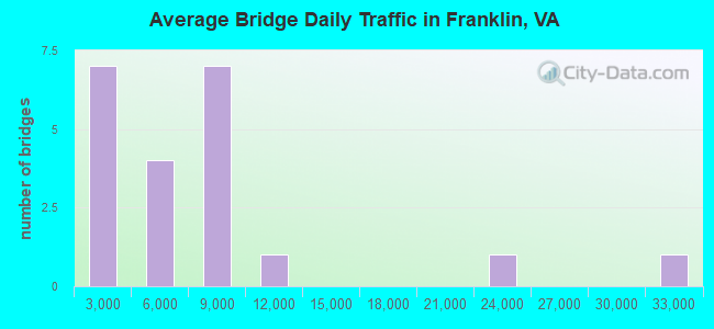
- 146,088Total average daily traffic
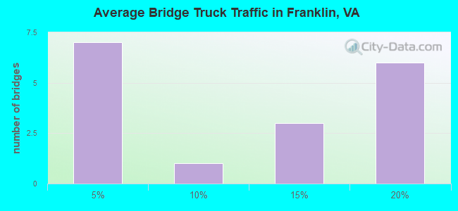
- 16,217Total average daily truck traffic
- National Bridge Inventory (NBI) Registered Bridges for Franklin
- No street view available for this location
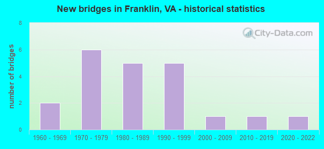
- New bridges - historical statistics
- 21960-1969
- 61970-1979
- 51980-1989
- 51990-1999
- 12000-2009
- 12010-2019
- 12020-2022
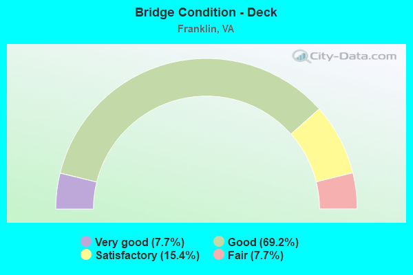
- Bridge Condition - Deck
- 7.7%Very good
- 69.2%Good
- 15.4%Satisfactory
- 7.7%Fair
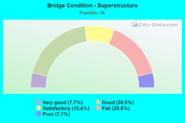
- Bridge Condition - Superstructure
- 7.7%Very good
- 38.5%Good
- 15.4%Satisfactory
- 30.8%Fair
- 7.7%Poor
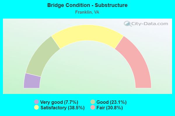
- Bridge Condition - Substructure
- 7.7%Very good
- 23.1%Good
- 38.5%Satisfactory
- 30.8%Fair
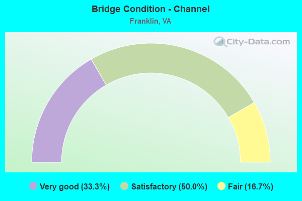
- Bridge Condition - Channel
- 33.3%Very good
- 50.0%Satisfactory
- 16.7%Fair
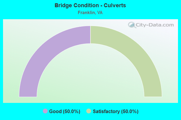
- Bridge Condition - Culverts
- 50.0%Good
- 50.0%Satisfactory
Find on map >> Show street view
Structure Number: 9412, Location: 0.08 TO 360 BUS & 0.22 (Lat: 37.602869, Lng: -77.370436), Route carried "on" structure: State highway 156, Year Built: 1968, Status: Temporarily open, Structure Length: 5.93m (19.46ft), Average Daily Traffic: 11,540 (year 2020), Truck Traffic: 1%, Average Future Daily Traffic: 16,156 (year 2040), Design Load: HS 20+Mod, Features Intersected: RTE 360, Facility Carried by Structure: COLD HARBOR ROAD
Minimum Vertical Clearance: 30.45m (99.90ft), Kilometerpoint: 97.834, Lanes on structure: 4, Lanes under structure: 4, Owner: State Highway Agency, Approaching Roadway Width: 16.5m (54.1ft), Skew: 20 degrees, Material/Design: Steel, Design/Construction: Stringer/Multi-beam, Number Of Spans In Main Unit: 4, Length of Maximum Span: 16.2m (53.1ft), Curb or Sidewalk Widths: Left: 1.5m (4.9ft), Right: 1.5m (4.9ft), Curb-To-Curb Width: 16.5m (54.1ft), Out-to-Out Width: 20.1m (65.9ft)
Condition: Deck: Fair, Superstructure: Poor, Substructure: Fair, Operating Rating: 34.6 metric tons, Method Used To Determine Operating Rating: Load and Resistance Factor (LRFR), Inventory Rating: 26.7 metric tons, Method Used To Determine Inventory Rating: Load and Resistance Factor (LRFR), Structural Evaluation: Meets minimum limits, Deck Geometry: Meets minimum limits, Underclear: High priority of corrective action, Approach Roadway Alignment: Equal to present desirable criteria, Length Of Structure Improvement: 5.85m (19.19ft), Designated Inspection Frequency: Every 12 months, Inspection Date: June 2021, Bridge Improvement Cost: $385,000, Roadway Improvement Cost: $120,000, Total Project Cost: $616,000, Deck Structure Type: Concrete Cast-file-Place
Find on map >> Show street view
Structure Number: 1774, Location: 2.64 TO 58BUS/0.98 TO 258 (Lat: 36.666097, Lng: -76.958956), Route carried "on" structure: Bypass US 58, Year Built: 1979, Status: Open, Structure Length: 6.40m (21.00ft), Average Daily Traffic: 7,841 (year 2020), Truck Traffic: 16%, Average Future Daily Traffic: 10,977 (year 2040), Design Load: HS 20+Mod, Features Intersected: Gen Thomas Hwy
Minimum Vertical Clearance: 30+ m (98+ ft), Kilometerpoint: 714.028, Lanes on structure: 2, Lanes under structure: 4, Base Highway Network: Yes, Owner: State Highway Agency, Approaching Roadway Width: 7.3m (24.0ft), Skew: 3 degrees, Material/Design: Steel, Design/Construction: Stringer/Multi-beam, Number Of Spans In Main Unit: 4, Length of Maximum Span: 19.7m (64.6ft), Curb-To-Curb Width: 11.6m (38.1ft), Out-to-Out Width: 12.8m (42.0ft)
Condition: Deck: Satisfactory, Superstructure: Satisfactory, Substructure: Fair, Operating Rating: 89.8 metric tons, Method Used To Determine Operating Rating: Load and Resistance Factor (LRFR), Inventory Rating: 84.7 metric tons, Method Used To Determine Inventory Rating: Load and Resistance Factor (LRFR), Structural Evaluation: Somewhat better than minimum adequacy, Deck Geometry: Better than present minimum criteria, Underclear: Meets minimum limits, Approach Roadway Alignment: Equal to present desirable criteria, Length Of Structure Improvement: 6.55m (21.49ft), Designated Inspection Frequency: Every 24 months, Inspection Date: October 2021, Bridge Improvement Cost: $725,000, Roadway Improvement Cost: $10,000, Total Project Cost: $1,080,000 ( Estimate for 2018), Deck Structure Type: Concrete Cast-file-Place, Wearing Surface/Protective System: Wearing Surface: Epoxy Overlay
Find on map >> Show street view
Structure Number: 17742, Location: 0.25 TO 671 0.73 FR 258 (Lat: 36.664419, Lng: -76.954989), Route carried "on" structure: Bypass US 58, Year Built: 1979, Status: Open, Structure Length: 5.61m (18.41ft), Average Daily Traffic: 7,841 (year 2020), Truck Traffic: 16%, Average Future Daily Traffic: 10,977 (year 2040), Design Load: HS 20+Mod, Features Intersected: CSX Railway
Minimum Vertical Clearance: 30+ m (98+ ft), Kilometerpoint: 714.422, Lanes on structure: 3, Base Highway Network: Yes, Owner: State Highway Agency, Approaching Roadway Width: 16.5m (54.1ft), Skew: 4 degrees, Material/Design: Steel, Design/Construction: Stringer/Multi-beam, Number Of Spans In Main Unit: 3, Length of Maximum Span: 19.4m (63.6ft), Curb-To-Curb Width: 15.2m (49.9ft), Out-to-Out Width: 16.5m (54.1ft)
Condition: Deck: Satisfactory, Superstructure: Fair, Substructure: Fair, Operating Rating: 71.7 metric tons, Method Used To Determine Operating Rating: Load and Resistance Factor (LRFR), Inventory Rating: 55.3 metric tons, Method Used To Determine Inventory Rating: Load and Resistance Factor (LRFR), Structural Evaluation: Somewhat better than minimum adequacy, Deck Geometry: Equal to present minimum criteria, Underclear: Better than present minimum criteria, Approach Roadway Alignment: Equal to present desirable criteria, Designated Inspection Frequency: Every 24 months, Inspection Date: October 2021, Deck Structure Type: Concrete Cast-file-Place, Wearing Surface/Protective System: Wearing Surface: Epoxy Overlay, Membrane: Epoxy
Find on map >> Show street view
Structure Number: 17744, Location: 0.97 Miles to Int Rte 671 (Lat: 36.661028, Lng: -76.942792), Route carried "on" structure: Bypass US 58, Year Built: 1980, Status: Open, Structure Length: 6.46m (21.19ft), Average Daily Traffic: 7,841 (year 2020), Truck Traffic: 16%, Average Future Daily Traffic: 10,977 (year 2040), Design Load: HS 20+Mod, Features Intersected: Route 258
Minimum Vertical Clearance: 5.21m (17.09ft), Kilometerpoint: 715.587, Lanes on structure: 2, Lanes under structure: 4, Base Highway Network: Yes, Owner: State Highway Agency, Approaching Roadway Width: 7.3m (24.0ft), Skew: 33 degrees, Material/Design: Steel, Design/Construction: Stringer/Multi-beam, Number Of Spans In Main Unit: 3, Length of Maximum Span: 48.8m (160.1ft), Curb-To-Curb Width: 12.8m (42.0ft), Out-to-Out Width: 13.4m (44.0ft)
Condition: Deck: Good, Superstructure: Fair, Substructure: Satisfactory, Operating Rating: 37.6 metric tons, Method Used To Determine Operating Rating: Load and Resistance Factor (LRFR), Inventory Rating: 29.0 metric tons, Method Used To Determine Inventory Rating: Load and Resistance Factor (LRFR), Structural Evaluation: Somewhat better than minimum adequacy, Deck Geometry: Equal to present desirable criteria, Underclear: Meets minimum limits, Approach Roadway Alignment: Equal to present desirable criteria, Designated Inspection Frequency: Every 24 months, Inspection Date: November 2021, Deck Structure Type: Concrete Cast-file-Place, Wearing Surface/Protective System: Wearing Surface: Epoxy Overlay, Deck Protection: Epoxy Coated Reinforcing
Find on map >> Show street view
Structure Number: 17816, Location: 1.15 MI. TO INT. RTE. 640 (Lat: 36.741239, Lng: -76.938481), Route carried "on" structure: County highway 635, Year Built: 1983, Status: Open, Structure Length: 1.65m (5.41ft), Average Daily Traffic: 1,090 (year 2020), Truck Traffic: 3%, Average Future Daily Traffic: 1,199 (year 2040), Design Load: HS 20+Mod, Features Intersected: Branch Cypress Swamp, Facility Carried by Structure: Black Creek Road
Minimum Vertical Clearance: 30+ m (98+ ft), Kilometerpoint: 1.995, Lanes on structure: 2, Owner: State Highway Agency, Approaching Roadway Width: 9.1m (29.9ft), Skew: 3 degrees, Material/Design: Prestressed concrete, Design/Construction: Box Beam or Girders - Multiple, Number Of Spans In Main Unit: 1, Length of Maximum Span: 16.5m (54.1ft), Curb-To-Curb Width: 8.7m (28.5ft), Out-to-Out Width: 9.8m (32.2ft)
Condition: Deck: Good, Superstructure: Satisfactory, Substructure: Satisfactory, Channel: Fair, Operating Rating: 85.1 metric tons, Method Used To Determine Operating Rating: Load and Resistance Factor (LRFR), Inventory Rating: 65.7 metric tons, Method Used To Determine Inventory Rating: Load and Resistance Factor (LRFR), Structural Evaluation: Equal to present minimum criteria, Deck Geometry: Somewhat better than minimum adequacy, Waterway Adequacy: Equal to present desirable criteria, Approach Roadway Alignment: Equal to present desirable criteria, Designated Inspection Frequency: Every 24 months, Inspection Date: October 2021, Deck Structure Type: Concrete Cast-file-Place, Wearing Surface/Protective System: Wearing Surface: Bituminous, Membrane: Epoxy
Find on map >> Show street view
Structure Number: 17831, Location: 0.05 TO 644 / 1.08 TO 641 (Lat: 36.702211, Lng: -76.980303), Route carried "on" structure: County highway 649, Year Built: 1976, Status: Open, Structure Length: 0.70m (2.30ft), Average Daily Traffic: 1,459 (year 2020), Truck Traffic: 2%, Average Future Daily Traffic: 1,605 (year 2040), Design Load: HS 20, Features Intersected: Branch, Facility Carried by Structure: Country Club Road
Minimum Vertical Clearance: 30+ m (98+ ft), Kilometerpoint: 4.409, Lanes on structure: 2, Owner: State Highway Agency, Approaching Roadway Width: 6.4m (21.0ft), Material/Design: Steel, Design/Construction: Culvert, Number Of Spans In Main Unit: 3, Length of Maximum Span: 1.8m (5.9ft)
Condition: Channel: Satisfactory, Culverts: Satisfactory, Operating Rating: 44.5 metric tons, Method Used To Determine Operating Rating: Load Factor (LF), Inventory Rating: 32.7 metric tons, Method Used To Determine Inventory Rating: Load Factor (LF), Structural Evaluation: Equal to present minimum criteria, Waterway Adequacy: Equal to present desirable criteria, Approach Roadway Alignment: Better than present minimum criteria, Designated Inspection Frequency: Every 24 months, Inspection Date: November 2021
Find on map >> Show street view
Structure Number: 17832, Location: 1.20 TO 650 & 0.50 TO 644 (Lat: 36.701125, Lng: -76.990389), Route carried "on" structure: County highway 649, Year Built: 1965, Year Reconstructed: 2007, Status: Open, Structure Length: 1.01m (3.31ft), Average Daily Traffic: 935 (year 2020), Truck Traffic: 2%, Average Future Daily Traffic: 1,028 (year 2040), Design Load: HS 20+Mod, Features Intersected: Nottoway Swamp, Facility Carried by Structure: Country Club Run
Minimum Vertical Clearance: 30+ m (98+ ft), Kilometerpoint: 3.492, Lanes on structure: 2, Owner: State Highway Agency, Approaching Roadway Width: 8.5m (27.9ft), Material/Design: Steel, Design/Construction: Stringer/Multi-beam, Number Of Spans In Main Unit: 1, Length of Maximum Span: 10.1m (33.1ft), Curb-To-Curb Width: 7.7m (25.3ft), Out-to-Out Width: 8.0m (26.2ft)
Condition: Deck: Good, Superstructure: Good, Substructure: Satisfactory, Channel: Satisfactory, Operating Rating: 53.8 metric tons, Method Used To Determine Operating Rating: Load and Resistance Factor (LRFR), Inventory Rating: 41.5 metric tons, Method Used To Determine Inventory Rating: Load and Resistance Factor (LRFR), Structural Evaluation: Equal to present minimum criteria, Deck Geometry: Meets minimum limits, Waterway Adequacy: Better than present minimum criteria, Approach Roadway Alignment: Equal to present desirable criteria, Length Of Structure Improvement: 2.35m (7.71ft), Designated Inspection Frequency: Every 24 months, Inspection Date: Febuary 2022, Bridge Improvement Cost: $152,000, Roadway Improvement Cost: $23,000, Total Project Cost: $228,000, Deck Structure Type: Wood or Timber, Wearing Surface/Protective System: Wearing Surface: Bituminous
Find on map >> Show street view
Structure Number: 17889, Location: 00.50 688 / 01.10 TO 58BU (Lat: 36.674569, Lng: -76.980097), Route carried "on" structure: County highway 687, Year Built: 1979, Status: Open, Structure Length: 6.52m (21.39ft), Average Daily Traffic: 1,574 (year 2018), Average Future Daily Traffic: 2,267 (year 2040), Design Load: HS 20+Mod, Features Intersected: Southampton Pkwy, Facility Carried by Structure: Delaware Road
Minimum Vertical Clearance: 30+ m (98+ ft), Kilometerpoint: 14.336, Lanes on structure: 2, Lanes under structure: 4, Owner: State Highway Agency, Approaching Roadway Width: 9.1m (29.9ft), Skew: 1 degrees, Material/Design: Steel continuous, Design/Construction: Stringer/Multi-beam, Number Of Spans In Main Unit: 2, Length of Maximum Span: 32.6m (107.0ft), Curb-To-Curb Width: 8.5m (27.9ft), Out-to-Out Width: 9.8m (32.2ft)
Condition: Deck: Good, Superstructure: Fair, Substructure: Satisfactory, Operating Rating: 59.9 metric tons, Method Used To Determine Operating Rating: Load and Resistance Factor (LRFR), Inventory Rating: 46.3 metric tons, Method Used To Determine Inventory Rating: Load and Resistance Factor (LRFR), Structural Evaluation: Somewhat better than minimum adequacy, Deck Geometry: Somewhat better than minimum adequacy, Underclear: Equal to present minimum criteria, Approach Roadway Alignment: Equal to present desirable criteria, Designated Inspection Frequency: Every 24 months, Inspection Date: November 2020, Deck Structure Type: Concrete Cast-file-Place, Wearing Surface/Protective System: Wearing Surface: Epoxy Overlay
Find on map >> Show street view
Structure Number: 17895, Location: 0.93 SCL FRANKLIN LINE (Lat: 36.647542, Lng: -76.911853), Route carried "on" structure: County highway 714, Year Built: 1980, Status: Open, Structure Length: 14.17m (46.49ft), Average Daily Traffic: 1,643 (year 2020), Truck Traffic: 3%, Average Future Daily Traffic: 2,034 (year 2040), Design Load: HS 20+Mod, Features Intersected: Rte58 (Southampton Pkwy), Facility Carried by Structure: Pretlow Street
Minimum Vertical Clearance: 30+ m (98+ ft), Kilometerpoint: 2.063, Lanes on structure: 2, Lanes under structure: 4, Owner: State Highway Agency, Approaching Roadway Width: 12.2m (40.0ft), Skew: 6 degrees, Material/Design: Steel, Design/Construction: Stringer/Multi-beam, Number Of Spans In Main Unit: 5, Length of Maximum Span: 39.3m (128.9ft), Curb-To-Curb Width: 11.6m (38.1ft), Out-to-Out Width: 12.7m (41.7ft)
Condition: Deck: Good, Superstructure: Fair, Substructure: Fair, Operating Rating: 77.6 metric tons, Method Used To Determine Operating Rating: Load and Resistance Factor (LRFR), Inventory Rating: 59.8 metric tons, Method Used To Determine Inventory Rating: Load and Resistance Factor (LRFR), Structural Evaluation: Somewhat better than minimum adequacy, Deck Geometry: Equal to present minimum criteria, Underclear: Meets minimum limits, Approach Roadway Alignment: Equal to present desirable criteria, Designated Inspection Frequency: Every 24 months, Inspection Date: October 2020, Deck Structure Type: Concrete Cast-file-Place, Wearing Surface/Protective System: Wearing Surface: Latex Concrete, Deck Protection: Epoxy Coated Reinforcing
Find on map >> Show street view
Structure Number: 23647, Location: 0.98 MI. TO INT. RTE. 258 (Lat: 36.666028, Lng: -76.959167), Route carried "on" structure: US 58, Year Built: 1993, Status: Open, Structure Length: 6.46m (21.19ft), Average Daily Traffic: 7,841 (year 2020), Truck Traffic: 16%, Average Future Daily Traffic: 10,977 (year 2040), Design Load: HS 20+Mod, Features Intersected: Gen Thomas Hwy
Minimum Vertical Clearance: 30+ m (98+ ft), Kilometerpoint: 714.026, Lanes on structure: 2, Lanes under structure: 4, Base Highway Network: Yes, Owner: State Highway Agency, Approaching Roadway Width: 13.4m (44.0ft), Skew: 3 degrees, Material/Design: Steel, Design/Construction: Stringer/Multi-beam, Number Of Spans In Main Unit: 4, Length of Maximum Span: 19.8m (65.0ft), Curb-To-Curb Width: 11.8m (38.7ft), Out-to-Out Width: 12.8m (42.0ft)
Condition: Deck: Good, Superstructure: Good, Substructure: Good, Operating Rating: 99.8 metric tons, Method Used To Determine Operating Rating: Load and Resistance Factor (LRFR), Inventory Rating: 84.6 metric tons, Method Used To Determine Inventory Rating: Load and Resistance Factor (LRFR), Structural Evaluation: Better than present minimum criteria, Deck Geometry: Better than present minimum criteria, Underclear: Meets minimum limits, Approach Roadway Alignment: Equal to present desirable criteria, Designated Inspection Frequency: Every 24 months, Inspection Date: October 2021, Deck Structure Type: Concrete Cast-file-Place, Wearing Surface/Protective System: Wearing Surface: Monolithic Concrete, Deck Protection: Epoxy Coated Reinforcing
Find on map >> Show street view
Structure Number: 23648, Location: 0.95TO 671/3.13 TOSUFF CL (Lat: 36.660906, Lng: -76.942936), Route carried "on" structure: Bypass US 58, Year Built: 1993, Status: Open, Structure Length: 6.39m (20.96ft), Average Daily Traffic: 7,841 (year 2020), Truck Traffic: 16%, Average Future Daily Traffic: 10,977 (year 2040), Design Load: HS 20+Mod, Features Intersected: Route 258
Minimum Vertical Clearance: 30+ m (98+ ft), Kilometerpoint: 715.587, Lanes on structure: 2, Lanes under structure: 4, Base Highway Network: Yes, Owner: State Highway Agency, Approaching Roadway Width: 7.3m (24.0ft), Skew: 33 degrees, Material/Design: Steel, Design/Construction: Stringer/Multi-beam, Number Of Spans In Main Unit: 3, Length of Maximum Span: 48.7m (159.8ft), Curb-To-Curb Width: 12.3m (40.4ft), Out-to-Out Width: 13.4m (44.0ft)
Condition: Deck: Good, Superstructure: Good, Substructure: Good, Operating Rating: 39.9 metric tons, Method Used To Determine Operating Rating: Load Factor (LF), Inventory Rating: 24.0 metric tons, Method Used To Determine Inventory Rating: Load Factor (LF), Structural Evaluation: Somewhat better than minimum adequacy, Deck Geometry: Better than present minimum criteria, Underclear: Meets minimum limits, Approach Roadway Alignment: Equal to present desirable criteria, Designated Inspection Frequency: Every 24 months, Inspection Date: November 2021, Deck Structure Type: Concrete Cast-file-Place, Wearing Surface/Protective System: Wearing Surface: Monolithic Concrete, Deck Protection: Epoxy Coated Reinforcing
Find on map >> Show street view
Structure Number: 23715, Location: 0.73 MI. TO INT. RTE. 258 (Lat: 36.664347, Lng: -76.955197), Route carried "on" structure: US 58, Year Built: 1993, Status: Open, Structure Length: 5.61m (18.41ft), Average Daily Traffic: 7,841 (year 2020), Truck Traffic: 16%, Average Future Daily Traffic: 10,977 (year 2040), Design Load: HS 20+Mod, Features Intersected: CSX Railroad
Minimum Vertical Clearance: 30+ m (98+ ft), Kilometerpoint: 714.428, Lanes on structure: 3, Base Highway Network: Yes, Owner: State Highway Agency, Approaching Roadway Width: 16.5m (54.1ft), Skew: 4 degrees, Material/Design: Steel, Design/Construction: Stringer/Multi-beam, Number Of Spans In Main Unit: 3, Length of Maximum Span: 19.4m (63.6ft), Curb-To-Curb Width: 15.2m (49.9ft), Out-to-Out Width: 16.5m (54.1ft)
Condition: Deck: Good, Superstructure: Good, Substructure: Satisfactory, Operating Rating: 74.4 metric tons, Method Used To Determine Operating Rating: Load and Resistance Factor (LRFR), Inventory Rating: 57.2 metric tons, Method Used To Determine Inventory Rating: Load and Resistance Factor (LRFR), Structural Evaluation: Equal to present minimum criteria, Deck Geometry: Equal to present minimum criteria, Underclear: Better than present minimum criteria, Approach Roadway Alignment: Equal to present desirable criteria, Designated Inspection Frequency: Every 24 months, Inspection Date: October 2021, Deck Structure Type: Concrete Cast-file-Place, Wearing Surface/Protective System: Wearing Surface: Monolithic Concrete, Deck Protection: Epoxy Coated Reinforcing
Find on map >> Show street view
Structure Number: 29234, Location: 0.0ISLW CO /0.00SOHAM CO (Lat: 36.680444, Lng: -76.918300), Route carried "on" structure: Business US 58, Year Built: 2009, Status: Open, Structure Length: 8.56m (28.08ft), Average Daily Traffic: 6,721 (year 2020), Truck Traffic: 2%, Average Future Daily Traffic: 7,393 (year 2040), Design Load: HS 20+Mod, Features Intersected: Blackwater River
Minimum Vertical Clearance: 30+ m (98+ ft), Kilometerpoint: 718.724, Lanes on structure: 4, Owner: State Highway Agency, Approaching Roadway Width: 15.9m (52.2ft), Material/Design: Prestressed concrete continuous, Design/Construction: Stringer/Multi-beam, Number Of Spans In Main Unit: 4, Length of Maximum Span: 21.3m (69.9ft), Curb or Sidewalk Widths: Left: 1.9m (6.2ft), Right: 1.9m (6.2ft), Curb-To-Curb Width: 15.6m (51.2ft), Out-to-Out Width: 20.3m (66.6ft)
Condition: Deck: Good, Superstructure: Good, Substructure: Good, Channel: Very good, Operating Rating: 51.7 metric tons, Method Used To Determine Operating Rating: Load and Resistance Factor (LRFR), Inventory Rating: 39.9 metric tons, Method Used To Determine Inventory Rating: Load and Resistance Factor (LRFR), Structural Evaluation: Better than present minimum criteria, Deck Geometry: Meets minimum limits, Waterway Adequacy: Superior to present desirable criteria, Approach Roadway Alignment: Equal to present desirable criteria, Designated Inspection Frequency: Every 24 months, Underwater Inspection Frequency: Every 60 months, Inspection Date: October 2021, Underwater Inspection Date: October 2019, Deck Structure Type: Concrete Cast-file-Place, Wearing Surface/Protective System: Wearing Surface: Epoxy Overlay, Membrane: Epoxy, Deck Protection: Epoxy Coated Reinforcing
Find on map >> Show street view
Structure Number: 29358, Location: 0.30 mi to Int Rte. 684 (Lat: 36.652911, Lng: -76.961297), Route carried "on" structure: County highway 688, Year Built: 2010, Status: Open, Structure Length: 0.78m (2.56ft), Average Daily Traffic: 492 (year 2018), Average Future Daily Traffic: 540 (year 2040), Design Load: HS 20, Features Intersected: Branch Nottoway River, Facility Carried by Structure: Rose Valley Road
Minimum Vertical Clearance: 30+ m (98+ ft), Kilometerpoint: 8.061, Lanes on structure: 2, Owner: State Highway Agency, Approaching Roadway Width: 6.1m (20.0ft), Material/Design: Steel, Design/Construction: Culvert, Number Of Spans In Main Unit: 3, Length of Maximum Span: 2.1m (6.9ft)
Condition: Channel: Satisfactory, Culverts: Good, Operating Rating: 44.5 metric tons, Method Used To Determine Operating Rating: Load Factor (LF), Inventory Rating: 32.7 metric tons, Method Used To Determine Inventory Rating: Load Factor (LF), Structural Evaluation: Better than present minimum criteria, Waterway Adequacy: Equal to present desirable criteria, Approach Roadway Alignment: Equal to present desirable criteria, Designated Inspection Frequency: Every 24 months, Inspection Date: January 2022
Find on map >> Show street view
Structure Number: 29676, Location: 3.0 Mi Fr Rte 58 (Lat: 36.650139, Lng: -77.011219), Route carried "on" structure: County highway 671, Year Built: 2021, Status: Open, Structure Length: 9.60m (31.50ft), Average Daily Traffic: 4,251 (year 2018), Truck Traffic: 9%, Average Future Daily Traffic: 6,900 (year 2035), Design Load: HL 93, Features Intersected: Overflow Nottoway River, Facility Carried by Structure: General Thomas Hwy
Minimum Vertical Clearance: 30+ m (98+ ft), Kilometerpoint: 18.331, Lanes on structure: 2, Owner: State Highway Agency, Approaching Roadway Width: 9.1m (29.9ft), Material/Design: Concrete continuous, Design/Construction: Stringer/Multi-beam, Number Of Spans In Main Unit: 3, Length of Maximum Span: 32.0m (105.0ft), Curb-To-Curb Width: 9.1m (29.9ft), Out-to-Out Width: 9.9m (32.5ft)
Condition: Deck: Very good, Superstructure: Very good, Substructure: Very good, Channel: Very good, Operating Rating: 88.6 metric tons, Method Used To Determine Operating Rating: Load and Resistance Factor (LRFR), Inventory Rating: 50.9 metric tons, Method Used To Determine Inventory Rating: Load and Resistance Factor (LRFR), Structural Evaluation: Equal to present desirable criteria, Deck Geometry: Meets minimum limits, Waterway Adequacy: Equal to present desirable criteria, Approach Roadway Alignment: Better than present minimum criteria, Designated Inspection Frequency: Every 24 months, Inspection Date: August 2021, Deck Structure Type: Concrete Cast-file-Place, Wearing Surface/Protective System: Wearing Surface: Latex Concrete, Deck Protection: Epoxy Coated Reinforcing
Find on map >> Show street view
Structure Number: 1774, Location: 2.64 TO 58BUS/0.98 TO 258 (Lat: 36.666097, Lng: -76.958956), Route carried "under" structure: County highway 671, Year Built: 1979, Structure Length: 0. m, Average Daily Traffic: 4,060 (year 2008), Truck Traffic: 12%, Features Intersected: Gen Thomas Hwy, Facility Carried by Structure: Route 58 WBL
Minimum Vertical Clearance: 5.39m (17.68ft), Kilometerpoint: 17.828, Lanes on structure: 2, Lanes under structure: 4, Material/Design: Steel, Design/Construction: Stringer/Multi-beam, Length of Maximum Span: 19.7m (64.6ft)
Find on map >> Show street view
Structure Number: 17744, Location: 0.97 Miles to Int Rte 671 (Lat: 36.661028, Lng: -76.942792), Route carried "under" structure: US 258, Year Built: 1980, Structure Length: 0. m, Average Daily Traffic: 5,066 (year 2008), Truck Traffic: 1%, Features Intersected: Route 258, Facility Carried by Structure: Route 58 WBL
Minimum Vertical Clearance: 5.12m (16.80ft), Kilometerpoint: 14.578, Lanes on structure: 2, Lanes under structure: 4, Material/Design: Steel, Design/Construction: Stringer/Multi-beam, Length of Maximum Span: 48.8m (160.1ft)
Find on map >> Show street view
Structure Number: 17889, Location: 00.50 688 / 01.10 TO 58BU (Lat: 36.674569, Lng: -76.980097), Route carried "under" structure: US 58, Year Built: 1979, Structure Length: 0. m, Average Daily Traffic: 21,446 (year 2008), Truck Traffic: 14%, Features Intersected: Southampton Pkwy, Facility Carried by Structure: Delaware Road
Minimum Vertical Clearance: 5.16m (16.93ft), Kilometerpoint: 711.902, Lanes on structure: 2, Lanes under structure: 4, Material/Design: Steel continuous, Design/Construction: Stringer/Multi-beam, Length of Maximum Span: 32.6m (107.0ft)
Find on map >> Show street view
Structure Number: 17895, Location: 0.93 SCL FRANKLIN LINE (Lat: 36.647542, Lng: -76.911853), Route carried "under" structure: US 58, Year Built: 1980, Structure Length: 0. m, Average Daily Traffic: 31,396 (year 2008), Truck Traffic: 14%, Features Intersected: Rte58 (Southampton Pkwy), Facility Carried by Structure: Pretlow Street
Minimum Vertical Clearance: 5.23m (17.16ft), Kilometerpoint: 718.676, Lanes on structure: 2, Lanes under structure: 4, Material/Design: Steel, Design/Construction: Stringer/Multi-beam, Length of Maximum Span: 39.3m (128.9ft)
Find on map >> Show street view
Structure Number: 23647, Location: 0.98 MI. TO INT. RTE. 258 (Lat: 36.666028, Lng: -76.959167), Route carried "under" structure: County highway 671, Year Built: 1993, Structure Length: 0. m, Average Daily Traffic: 4,649 (year 1994), Features Intersected: Gen Thomas Hwy, Facility Carried by Structure: Route 58 EBL
Minimum Vertical Clearance: 5.21m (17.09ft), Kilometerpoint: 6.597, Lanes on structure: 2, Lanes under structure: 4, Material/Design: Steel, Design/Construction: Stringer/Multi-beam, Length of Maximum Span: 19.8m (65.0ft)
Find on map >> Show street view
Structure Number: 23648, Location: 0.95TO 671/3.13 TOSUFF CL (Lat: 36.660906, Lng: -76.942936), Route carried "under" structure: US 258, Year Built: 1993, Structure Length: 0. m, Average Daily Traffic: 2,720 (year 1994), Features Intersected: Route 258, Facility Carried by Structure: Route 58 EBL
Minimum Vertical Clearance: 5.26m (17.26ft), Kilometerpoint: 14.578, Lanes on structure: 2, Lanes under structure: 4, Material/Design: Steel, Design/Construction: Stringer/Multi-beam, Length of Maximum Span: 48.7m (159.8ft)