Bridge Statistics for Frazeysburg, Ohio (OH)
Condition, Traffic, Stress, Structural Evaluation, Project Costs
- National Bridge Inventory (NBI) Statistics
- 35Number of bridges
- 410ft / 125mTotal length
- 63,601Total average daily traffic
- 7,549Total average daily truck traffic
- National Bridge Inventory (NBI) Registered Bridges for Frazeysburg
- No street view available for this location
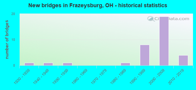
- New bridges - historical statistics
- 11930-1939
- 11940-1949
- 11950-1959
- 11980-1989
- 81990-1999
- 192000-2009
- 42010-2019


- Bridge Condition - Deck
- 12.5%Excellent
- 41.7%Very good
- 25.0%Good
- 12.5%Satisfactory
- 8.3%Fair

- Bridge Condition - Superstructure
- 16.7%Excellent
- 45.8%Very good
- 25.0%Good
- 4.2%Satisfactory
- 8.3%Fair

- Bridge Condition - Substructure
- 20.8%Excellent
- 37.5%Very good
- 29.2%Good
- 4.2%Satisfactory
- 8.3%Fair

- Bridge Condition - Channel
- 15.4%Excellent
- 15.4%Very good
- 30.8%Good
- 30.8%Satisfactory
- 7.7%Fair
Find on map >> Show street view
Structure Number: 1630784, Location: 0.2 mile N jct TR4 (Lat: 40.171600, Lng: -82.124931), Route carried "on" structure: County highway C0080, Year Built: 1998, Status: Open, Structure Length: 1.13m (3.71ft), Average Daily Traffic: 458 (year 2015), Truck Traffic: 7%, Average Future Daily Traffic: 636 (year 2035), Design Load: HS 20+Mod, Features Intersected: FIVE MILE RUN, Facility Carried by Structure: COUNTY ROAD 80
Minimum Vertical Clearance: 30+ m (98+ ft), Kilometerpoint: 0.064, Lanes on structure: 2, Owner: County Highway Agency, Approaching Roadway Width: 5.5m (18.0ft), Material/Design: Prestressed concrete, Design/Construction: Box Beam or Girders - Multiple, Number Of Spans In Main Unit: 1, Length of Maximum Span: 10.1m (33.1ft), Curb-To-Curb Width: 7.3m (24.0ft), Out-to-Out Width: 7.8m (25.6ft)
Condition: Deck: Good, Superstructure: Good, Substructure: Fair, Channel: Fair, Operating Rating: 42.1 metric tons, Method Used To Determine Operating Rating: Load Factor (LF) rating reported by rating factor (RF) method using MS18 loading, Inventory Rating: 32.4 metric tons, Method Used To Determine Inventory Rating: Load Factor (LF) rating reported by rating factor (RF) method using MS18 loading, Structural Evaluation: Somewhat better than minimum adequacy, Deck Geometry: Meets minimum limits, Waterway Adequacy: Equal to present desirable criteria, Approach Roadway Alignment: Equal to present desirable criteria, Designated Inspection Frequency: Every 12 months, Inspection Date: March 2021, Deck Structure Type: Concrete Cast-file-Place, Wearing Surface/Protective System: Wearing Surface: Bituminous, Membrane: Preformed Fabric
Find on map >> Show street view
Structure Number: 163195, Location: 0.2 mile N jct TR392 (Lat: 40.175450, Lng: -82.149400), Route carried "on" structure: County highway C0003, Year Built: 1998, Status: Open, Structure Length: 0.91m (2.99ft), Average Daily Traffic: 254 (year 2015), Truck Traffic: 7%, Average Future Daily Traffic: 353 (year 2035), Design Load: HS 20, Features Intersected: NICKLE VALLEY RUN, Facility Carried by Structure: COUNTY ROAD 3
Minimum Vertical Clearance: 30+ m (98+ ft), Kilometerpoint: 0.016, Lanes on structure: 2, Owner: County Highway Agency, Approaching Roadway Width: 5.8m (19.0ft), Material/Design: Steel, Design/Construction: Stringer/Multi-beam, Number Of Spans In Main Unit: 1, Length of Maximum Span: 8.8m (28.9ft), Curb-To-Curb Width: 6.1m (20.0ft), Out-to-Out Width: 6.1m (20.0ft)
Condition: Deck: Fair, Superstructure: Good, Substructure: Fair, Channel: Satisfactory, Operating Rating: 48.6 metric tons, Method Used To Determine Operating Rating: Load Factor (LF) rating reported by rating factor (RF) method using MS18 loading, Inventory Rating: 29.2 metric tons, Method Used To Determine Inventory Rating: Load Factor (LF) rating reported by rating factor (RF) method using MS18 loading, Structural Evaluation: Somewhat better than minimum adequacy, Deck Geometry: Meets minimum limits, Waterway Adequacy: Equal to present desirable criteria, Approach Roadway Alignment: Equal to present minimum criteria, Designated Inspection Frequency: Every 12 months, Inspection Date: March 2021, Deck Structure Type: Wood or Timber, Wearing Surface/Protective System: Wearing Surface: Bituminous
Find on map >> Show street view
Structure Number: 1635131, Location: 0.1 mile E jct CR80 (Lat: 40.168869, Lng: -82.124411), Route carried "on" structure: County highway T0004, Year Built: 2012, Status: Open, Structure Length: 1.34m (4.40ft), Average Daily Traffic: 209 (year 2015), Truck Traffic: 7%, Average Future Daily Traffic: 290 (year 2035), Design Load: HL 93, Features Intersected: FIVE MILE RUN, Facility Carried by Structure: TOWNSHIP ROAD 4
Minimum Vertical Clearance: 30+ m (98+ ft), Kilometerpoint: 0.161, Lanes on structure: 2, Owner: County Highway Agency, Approaching Roadway Width: 3.4m (11.2ft), Material/Design: Prestressed concrete, Design/Construction: Box Beam or Girders - Multiple, Number Of Spans In Main Unit: 1, Length of Maximum Span: 13.1m (43.0ft), Curb-To-Curb Width: 6.2m (20.3ft), Out-to-Out Width: 6.2m (20.3ft)
Condition: Deck: Good, Superstructure: Very good, Substructure: Very good, Channel: Good, Operating Rating: 51.8 metric tons, Method Used To Determine Operating Rating: Load Factor (LF) rating reported by rating factor (RF) method using MS18 loading, Inventory Rating: 38.9 metric tons, Method Used To Determine Inventory Rating: Load Factor (LF) rating reported by rating factor (RF) method using MS18 loading, Structural Evaluation: Equal to present desirable criteria, Deck Geometry: Meets minimum limits, Waterway Adequacy: Equal to present desirable criteria, Approach Roadway Alignment: Equal to present desirable criteria, Designated Inspection Frequency: Every 24 months, Inspection Date: March 2021, Deck Structure Type: Concrete Cast-file-Place, Wearing Surface/Protective System: Wearing Surface: Bituminous
Find on map >> Show street view
Structure Number: 6000061, Location: 2.6 M E OF LICKING CO LIN (Lat: 40.115811, Lng: -82.155950), Route carried "on" structure: State highway 16, Year Built: 1999, Status: Open, Structure Length: 4.32m (14.17ft), Average Daily Traffic: 3,203 (year 2015), Truck Traffic: 13%, Average Future Daily Traffic: 4,446 (year 2035), Design Load: HS 20+Mod, Features Intersected: WB SR 16 OVER RAIDERS RD
Minimum Vertical Clearance: 30+ m (98+ ft), Kilometerpoint: 4.233, Lanes on structure: 2, Lanes under structure: 2, Base Highway Network: Yes, Owner: State Highway Agency, Approaching Roadway Width: 12.8m (42.0ft), Skew: 4 degrees, Material/Design: Steel, Design/Construction: Stringer/Multi-beam, Number Of Spans In Main Unit: 1, Length of Maximum Span: 42.4m (139.1ft), Curb-To-Curb Width: 12.8m (42.0ft), Out-to-Out Width: 13.8m (45.3ft)
Condition: Deck: Very good, Superstructure: Very good, Substructure: Good, Operating Rating: 42.1 metric tons, Method Used To Determine Operating Rating: Load Factor (LF) rating reported by rating factor (RF) method using MS18 loading, Inventory Rating: 32.4 metric tons, Method Used To Determine Inventory Rating: Load Factor (LF) rating reported by rating factor (RF) method using MS18 loading, Structural Evaluation: Better than present minimum criteria, Deck Geometry: Equal to present desirable criteria, Underclear: High priority of corrective action, Approach Roadway Alignment: Better than present minimum criteria, Designated Inspection Frequency: Every 24 months, Inspection Date: September 2021, Deck Structure Type: Concrete Cast-file-Place, Wearing Surface/Protective System: Wearing Surface: Monolithic Concrete, Deck Protection: Epoxy Coated Reinforcing
Find on map >> Show street view
Structure Number: 6000088, Location: 2.6 M E OF LICKING CO LIN (Lat: 40.115781, Lng: -82.155539), Route carried "on" structure: State highway 16, Year Built: 1999, Status: Open, Structure Length: 4.41m (14.47ft), Average Daily Traffic: 3,203 (year 2015), Truck Traffic: 13%, Average Future Daily Traffic: 4,446 (year 2035), Design Load: HS 20+Mod, Features Intersected: EB SR 16 OVER RAIDERS RD
Minimum Vertical Clearance: 30+ m (98+ ft), Kilometerpoint: 4.233, Lanes on structure: 2, Lanes under structure: 2, Base Highway Network: Yes, Owner: State Highway Agency, Approaching Roadway Width: 12.8m (42.0ft), Skew: 4 degrees, Material/Design: Steel, Design/Construction: Stringer/Multi-beam, Number Of Spans In Main Unit: 1, Length of Maximum Span: 42.4m (139.1ft), Curb-To-Curb Width: 12.8m (42.0ft), Out-to-Out Width: 13.8m (45.3ft)
Condition: Deck: Very good, Superstructure: Very good, Substructure: Good, Operating Rating: 42.1 metric tons, Method Used To Determine Operating Rating: Load Factor (LF) rating reported by rating factor (RF) method using MS18 loading, Inventory Rating: 32.4 metric tons, Method Used To Determine Inventory Rating: Load Factor (LF) rating reported by rating factor (RF) method using MS18 loading, Structural Evaluation: Better than present minimum criteria, Deck Geometry: Equal to present desirable criteria, Underclear: High priority of corrective action, Approach Roadway Alignment: Better than present minimum criteria, Designated Inspection Frequency: Every 24 months, Inspection Date: September 2021, Deck Structure Type: Concrete Cast-file-Place, Wearing Surface/Protective System: Wearing Surface: Monolithic Concrete, Deck Protection: Epoxy Coated Reinforcing
Find on map >> Show street view
Structure Number: 6000118, Location: 2.5 M W OF JCT SR 60 (Lat: 40.149989, Lng: -82.072519), Route carried "on" structure: State highway 16, Year Built: 2001, Status: Open, Structure Length: 1.71m (5.61ft), Average Daily Traffic: 3,099 (year 2015), Truck Traffic: 13%, Average Future Daily Traffic: 4,301 (year 2035), Design Load: HS 20+Mod, Features Intersected: WB SR 16 OVER TR 118
Minimum Vertical Clearance: 30+ m (98+ ft), Kilometerpoint: 12.376, Lanes on structure: 2, Lanes under structure: 2, Base Highway Network: Yes, Owner: State Highway Agency, Approaching Roadway Width: 12.8m (42.0ft), Skew: 2 degrees, Material/Design: Steel, Design/Construction: Stringer/Multi-beam, Number Of Spans In Main Unit: 1, Length of Maximum Span: 16.5m (54.1ft), Curb-To-Curb Width: 12.8m (42.0ft), Out-to-Out Width: 13.7m (44.9ft)
Condition: Deck: Very good, Superstructure: Very good, Substructure: Very good, Operating Rating: 22.7 metric tons, Method Used To Determine Operating Rating: Load Factor (LF) rating reported by rating factor (RF) method using MS18 loading, Inventory Rating: 19.4 metric tons, Method Used To Determine Inventory Rating: Load Factor (LF) rating reported by rating factor (RF) method using MS18 loading, Structural Evaluation: Somewhat better than minimum adequacy, Deck Geometry: Equal to present desirable criteria, Underclear: Equal to present minimum criteria, Approach Roadway Alignment: Better than present minimum criteria, Designated Inspection Frequency: Every 24 months, Inspection Date: October 2021, Deck Structure Type: Concrete Cast-file-Place, Wearing Surface/Protective System: Wearing Surface: Monolithic Concrete, Membrane: Epoxy, Deck Protection: Epoxy Coated Reinforcing
Find on map >> Show street view
Structure Number: 6000177, Location: 3.8 M W OF JCT SR 60 (Lat: 40.140250, Lng: -82.093189), Route carried "on" structure: State highway 16, Year Built: 2002, Status: Open, Structure Length: 6.79m (22.28ft), Average Daily Traffic: 2,818 (year 2015), Truck Traffic: 13%, Average Future Daily Traffic: 3,911 (year 2035), Design Load: HS 25 or greater, Features Intersected: WB SR 16 OVER PRIVATE RD
Minimum Vertical Clearance: 30+ m (98+ ft), Kilometerpoint: 10.316, Lanes on structure: 3, Base Highway Network: Yes, Owner: State Highway Agency, Approaching Roadway Width: 15.9m (52.2ft), Skew: 3 degrees, Material/Design: Prestressed concrete, Design/Construction: Stringer/Multi-beam, Number Of Spans In Main Unit: 2, Length of Maximum Span: 36.6m (120.1ft), Curb-To-Curb Width: 15.9m (52.2ft), Out-to-Out Width: 16.8m (55.1ft)
Condition: Deck: Very good, Superstructure: Very good, Substructure: Very good, Operating Rating: 42.1 metric tons, Method Used To Determine Operating Rating: Load Factor (LF) rating reported by rating factor (RF) method using MS18 loading, Inventory Rating: 32.4 metric tons, Method Used To Determine Inventory Rating: Load Factor (LF) rating reported by rating factor (RF) method using MS18 loading, Structural Evaluation: Equal to present desirable criteria, Deck Geometry: Better than present minimum criteria, Approach Roadway Alignment: Better than present minimum criteria, Designated Inspection Frequency: Every 24 months, Inspection Date: October 2021, Deck Structure Type: Concrete Cast-file-Place, Wearing Surface/Protective System: Wearing Surface: Monolithic Concrete, Membrane: Epoxy, Deck Protection: Epoxy Coated Reinforcing
Find on map >> Show street view
Structure Number: 6000215, Location: 3.7 MI E OF LIC CO. LINE (Lat: 40.124250, Lng: -82.138681), Route carried "on" structure: State highway 16, Year Built: 2000, Status: Open, Structure Length: 20.59m (67.55ft), Average Daily Traffic: 3,203 (year 2015), Truck Traffic: 13%, Average Future Daily Traffic: 4,446 (year 2035), Design Load: HS 20+Mod, Features Intersected: WAKATOMIKA CK & CR 38
Minimum Vertical Clearance: 30+ m (98+ ft), Kilometerpoint: 5.955, Lanes on structure: 2, Lanes under structure: 2, Base Highway Network: Yes, Owner: State Highway Agency, Approaching Roadway Width: 12.8m (42.0ft), Material/Design: Steel continuous, Design/Construction: Stringer/Multi-beam, Number Of Spans In Main Unit: 3, Length of Maximum Span: 82.3m (270.0ft), Curb-To-Curb Width: 12.8m (42.0ft), Out-to-Out Width: 13.8m (45.3ft)
Condition: Deck: Satisfactory, Superstructure: Good, Substructure: Good, Channel: Good, Operating Rating: 42.1 metric tons, Method Used To Determine Operating Rating: Load Factor (LF) rating reported by rating factor (RF) method using MS18 loading, Inventory Rating: 32.4 metric tons, Method Used To Determine Inventory Rating: Load Factor (LF) rating reported by rating factor (RF) method using MS18 loading, Structural Evaluation: Better than present minimum criteria, Deck Geometry: Equal to present desirable criteria, Underclear: Meets minimum limits, Waterway Adequacy: Superior to present desirable criteria, Approach Roadway Alignment: Equal to present desirable criteria, Designated Inspection Frequency: Every 12 months, Inspection Date: November 2021, Deck Structure Type: Concrete Cast-file-Place, Wearing Surface/Protective System: Wearing Surface: Monolithic Concrete, Membrane: Epoxy, Deck Protection: Epoxy Coated Reinforcing
Find on map >> Show street view
Structure Number: 6000223, Location: 3.7 MI E OF LIC CO LINE (Lat: 40.124031, Lng: -82.138581), Route carried "on" structure: State highway 16, Year Built: 2000, Status: Open, Structure Length: 20.59m (67.55ft), Average Daily Traffic: 3,203 (year 2015), Truck Traffic: 13%, Average Future Daily Traffic: 4,446 (year 2035), Design Load: HS 20+Mod, Features Intersected: WAKATOMIKA CK & CR 38
Minimum Vertical Clearance: 30+ m (98+ ft), Kilometerpoint: 5.955, Lanes on structure: 2, Lanes under structure: 2, Base Highway Network: Yes, Owner: State Highway Agency, Approaching Roadway Width: 12.8m (42.0ft), Material/Design: Steel continuous, Design/Construction: Stringer/Multi-beam, Number Of Spans In Main Unit: 3, Length of Maximum Span: 82.3m (270.0ft), Curb-To-Curb Width: 12.8m (42.0ft), Out-to-Out Width: 13.8m (45.3ft)
Condition: Deck: Good, Superstructure: Good, Substructure: Very good, Channel: Good, Operating Rating: 42.1 metric tons, Method Used To Determine Operating Rating: Load Factor (LF) rating reported by rating factor (RF) method using MS18 loading, Inventory Rating: 32.4 metric tons, Method Used To Determine Inventory Rating: Load Factor (LF) rating reported by rating factor (RF) method using MS18 loading, Structural Evaluation: Better than present minimum criteria, Deck Geometry: Equal to present desirable criteria, Underclear: Meets minimum limits, Waterway Adequacy: Superior to present desirable criteria, Approach Roadway Alignment: Equal to present desirable criteria, Designated Inspection Frequency: Every 24 months, Inspection Date: November 2021, Deck Structure Type: Concrete Cast-file-Place, Wearing Surface/Protective System: Wearing Surface: Monolithic Concrete, Membrane: Epoxy, Deck Protection: Epoxy Coated Reinforcing
Find on map >> Show street view
Structure Number: 6000231, Location: 4.3 MI E OF LIC CO LINE (Lat: 40.126881, Lng: -82.128050), Route carried "on" structure: State highway 16, Year Built: 2000, Status: Open, Structure Length: 2.40m (7.87ft), Average Daily Traffic: 3,203 (year 2015), Truck Traffic: 13%, Average Future Daily Traffic: 4,446 (year 2035), Design Load: HS 20+Mod, Features Intersected: WB SR 16 OVER CR 94
Minimum Vertical Clearance: 30+ m (98+ ft), Kilometerpoint: 6.936, Lanes on structure: 2, Lanes under structure: 2, Base Highway Network: Yes, Owner: State Highway Agency, Approaching Roadway Width: 12.8m (42.0ft), Skew: 4 degrees, Material/Design: Steel, Design/Construction: Stringer/Multi-beam, Number Of Spans In Main Unit: 1, Length of Maximum Span: 23.2m (76.1ft), Curb-To-Curb Width: 12.8m (42.0ft), Out-to-Out Width: 13.8m (45.3ft)
Condition: Deck: Good, Superstructure: Good, Substructure: Good, Operating Rating: 42.1 metric tons, Method Used To Determine Operating Rating: Load Factor (LF) rating reported by rating factor (RF) method using MS18 loading, Inventory Rating: 32.4 metric tons, Method Used To Determine Inventory Rating: Load Factor (LF) rating reported by rating factor (RF) method using MS18 loading, Structural Evaluation: Better than present minimum criteria, Deck Geometry: Equal to present desirable criteria, Underclear: Somewhat better than minimum adequacy, Approach Roadway Alignment: Equal to present desirable criteria, Designated Inspection Frequency: Every 24 months, Inspection Date: October 2021, Deck Structure Type: Concrete Cast-file-Place, Wearing Surface/Protective System: Wearing Surface: Monolithic Concrete, Membrane: Epoxy, Deck Protection: Epoxy Coated Reinforcing
Find on map >> Show street view
Structure Number: 6000258, Location: 4.3 MI E OF LIC CO LINE (Lat: 40.126711, Lng: -82.127611), Route carried "on" structure: State highway 16, Year Built: 2000, Status: Open, Structure Length: 2.40m (7.87ft), Average Daily Traffic: 3,203 (year 2015), Truck Traffic: 13%, Average Future Daily Traffic: 4,446 (year 2035), Design Load: HS 20+Mod, Features Intersected: EB SR 16 OVER CR 94
Minimum Vertical Clearance: 30+ m (98+ ft), Kilometerpoint: 6.936, Lanes on structure: 2, Lanes under structure: 2, Base Highway Network: Yes, Owner: State Highway Agency, Approaching Roadway Width: 12.8m (42.0ft), Skew: 4 degrees, Material/Design: Steel, Design/Construction: Stringer/Multi-beam, Number Of Spans In Main Unit: 1, Length of Maximum Span: 23.2m (76.1ft), Curb-To-Curb Width: 12.8m (42.0ft), Out-to-Out Width: 13.8m (45.3ft)
Condition: Deck: Good, Superstructure: Good, Substructure: Good, Operating Rating: 42.1 metric tons, Method Used To Determine Operating Rating: Load Factor (LF) rating reported by rating factor (RF) method using MS18 loading, Inventory Rating: 32.4 metric tons, Method Used To Determine Inventory Rating: Load Factor (LF) rating reported by rating factor (RF) method using MS18 loading, Structural Evaluation: Better than present minimum criteria, Deck Geometry: Equal to present desirable criteria, Underclear: Somewhat better than minimum adequacy, Approach Roadway Alignment: Equal to present desirable criteria, Designated Inspection Frequency: Every 24 months, Inspection Date: October 2021, Deck Structure Type: Concrete Cast-file-Place, Wearing Surface/Protective System: Wearing Surface: Monolithic Concrete, Membrane: Epoxy, Deck Protection: Epoxy Coated Reinforcing
Find on map >> Show street view
Structure Number: 6000266, Location: 5.1 MI E OF LIC CO LINE (Lat: 40.129381, Lng: -82.113089), Route carried "on" structure: County highway CR48, Year Built: 2000, Status: Open, Structure Length: 7.40m (24.28ft), Average Daily Traffic: 462 (year 2015), Truck Traffic: 2%, Average Future Daily Traffic: 8,890 (year 2035), Design Load: HS 20+Mod, Features Intersected: CR 48 OVER SR 16, Facility Carried by Structure: CR 48(SCOUT ROAD)
Minimum Vertical Clearance: 30+ m (98+ ft), Kilometerpoint: 160.918, Lanes on structure: 2, Lanes under structure: 4, Owner: State Highway Agency, Approaching Roadway Width: 13.4m (44.0ft), Skew: 4 degrees, Material/Design: Steel continuous, Design/Construction: Stringer/Multi-beam, Number Of Spans In Main Unit: 2, Length of Maximum Span: 36.6m (120.1ft), Curb-To-Curb Width: 13.4m (44.0ft), Out-to-Out Width: 14.4m (47.2ft)
Condition: Deck: Very good, Superstructure: Very good, Substructure: Very good, Operating Rating: 42.1 metric tons, Method Used To Determine Operating Rating: Load Factor (LF) rating reported by rating factor (RF) method using MS18 loading, Inventory Rating: 32.4 metric tons, Method Used To Determine Inventory Rating: Load Factor (LF) rating reported by rating factor (RF) method using MS18 loading, Structural Evaluation: Equal to present desirable criteria, Deck Geometry: Superior to present desirable criteria, Underclear: High priority of corrective action, Approach Roadway Alignment: Equal to present desirable criteria, Designated Inspection Frequency: Every 24 months, Inspection Date: October 2021, Deck Structure Type: Concrete Cast-file-Place, Wearing Surface/Protective System: Wearing Surface: Monolithic Concrete, Membrane: Epoxy, Deck Protection: Epoxy Coated Reinforcing
Find on map >> Show street view
Structure Number: 6000282, Location: 6 MI E OF LIC CO LINE (Lat: 40.136731, Lng: -82.099119), Route carried "on" structure: County highway T0098, Year Built: 2000, Status: Open, Structure Length: 6.93m (22.74ft), Average Daily Traffic: 219 (year 2015), Truck Traffic: 8%, Average Future Daily Traffic: 7,821 (year 2035), Design Load: HS 20+Mod, Features Intersected: TR 98 OVER SR 16, Facility Carried by Structure: TR 98 OLD RILEY RD
Minimum Vertical Clearance: 30+ m (98+ ft), Kilometerpoint: 1.609, Lanes on structure: 5, Lanes under structure: 4, Owner: State Highway Agency, Approaching Roadway Width: 24.4m (80.1ft), Skew: 3 degrees, Material/Design: Steel continuous, Design/Construction: Stringer/Multi-beam, Number Of Spans In Main Unit: 2, Length of Maximum Span: 34.3m (112.5ft), Curb-To-Curb Width: 24.4m (80.1ft), Out-to-Out Width: 25.4m (83.3ft)
Condition: Deck: Very good, Superstructure: Very good, Substructure: Very good, Operating Rating: 42.1 metric tons, Method Used To Determine Operating Rating: Load Factor (LF) rating reported by rating factor (RF) method using MS18 loading, Inventory Rating: 32.4 metric tons, Method Used To Determine Inventory Rating: Load Factor (LF) rating reported by rating factor (RF) method using MS18 loading, Structural Evaluation: Equal to present desirable criteria, Deck Geometry: Superior to present desirable criteria, Underclear: High priority of corrective action, Approach Roadway Alignment: Equal to present desirable criteria, Designated Inspection Frequency: Every 24 months, Inspection Date: October 2021, Deck Structure Type: Concrete Cast-file-Place, Wearing Surface/Protective System: Wearing Surface: Monolithic Concrete, Membrane: Epoxy, Deck Protection: Epoxy Coated Reinforcing
Find on map >> Show street view
Structure Number: 600029, Location: 3.8 M W OF JCT SR 60 (Lat: 40.140111, Lng: -82.092800), Route carried "on" structure: State highway 16, Year Built: 2002, Status: Open, Structure Length: 6.79m (22.28ft), Average Daily Traffic: 2,818 (year 2015), Truck Traffic: 13%, Average Future Daily Traffic: 3,911 (year 2035), Design Load: HS 25 or greater, Features Intersected: EB SR 16 OVER PRIVATE RD
Minimum Vertical Clearance: 30+ m (98+ ft), Kilometerpoint: 10.316, Lanes on structure: 3, Base Highway Network: Yes, Owner: State Highway Agency, Approaching Roadway Width: 19.4m (63.6ft), Skew: 3 degrees, Material/Design: Prestressed concrete, Design/Construction: Stringer/Multi-beam, Number Of Spans In Main Unit: 2, Length of Maximum Span: 36.6m (120.1ft), Curb-To-Curb Width: 19.4m (63.6ft), Out-to-Out Width: 21.3m (69.9ft)
Condition: Deck: Very good, Superstructure: Very good, Substructure: Very good, Operating Rating: 42.1 metric tons, Method Used To Determine Operating Rating: Load Factor (LF) rating reported by rating factor (RF) method using MS18 loading, Inventory Rating: 32.4 metric tons, Method Used To Determine Inventory Rating: Load Factor (LF) rating reported by rating factor (RF) method using MS18 loading, Structural Evaluation: Equal to present desirable criteria, Deck Geometry: Superior to present desirable criteria, Approach Roadway Alignment: Better than present minimum criteria, Designated Inspection Frequency: Every 24 months, Inspection Date: October 2021, Deck Structure Type: Concrete Cast-file-Place, Wearing Surface/Protective System: Wearing Surface: Monolithic Concrete, Membrane: Epoxy, Deck Protection: Epoxy Coated Reinforcing
Find on map >> Show street view
Structure Number: 6000347, Location: 2.5 M W OF JCT SR 60 (Lat: 40.149789, Lng: -82.072281), Route carried "on" structure: State highway 16, Year Built: 2001, Status: Open, Structure Length: 1.71m (5.61ft), Average Daily Traffic: 3,099 (year 2015), Truck Traffic: 13%, Average Future Daily Traffic: 4,301 (year 2035), Design Load: HS 20+Mod, Features Intersected: EB SR 16 OVER TR 118
Minimum Vertical Clearance: 30+ m (98+ ft), Kilometerpoint: 12.376, Lanes on structure: 2, Lanes under structure: 2, Base Highway Network: Yes, Owner: State Highway Agency, Approaching Roadway Width: 12.8m (42.0ft), Skew: 2 degrees, Material/Design: Steel, Design/Construction: Stringer/Multi-beam, Number Of Spans In Main Unit: 1, Length of Maximum Span: 16.5m (54.1ft), Curb-To-Curb Width: 12.8m (42.0ft), Out-to-Out Width: 13.7m (44.9ft)
Condition: Deck: Very good, Superstructure: Very good, Substructure: Very good, Operating Rating: 22.7 metric tons, Method Used To Determine Operating Rating: Load Factor (LF) rating reported by rating factor (RF) method using MS18 loading, Inventory Rating: 19.4 metric tons, Method Used To Determine Inventory Rating: Load Factor (LF) rating reported by rating factor (RF) method using MS18 loading, Structural Evaluation: Somewhat better than minimum adequacy, Deck Geometry: Equal to present desirable criteria, Underclear: Equal to present minimum criteria, Approach Roadway Alignment: Better than present minimum criteria, Designated Inspection Frequency: Every 24 months, Inspection Date: October 2021, Deck Structure Type: Concrete Cast-file-Place, Wearing Surface/Protective System: Wearing Surface: Monolithic Concrete, Membrane: Epoxy, Deck Protection: Epoxy Coated Reinforcing
Find on map >> Show street view
Structure Number: 6006302, Location: .6 MI S OF JCT SR 16 (Lat: 40.098931, Lng: -82.169639), Route carried "on" structure: State highway 586, Year Built: 1946, Status: Open, Structure Length: 0.85m (2.79ft), Average Daily Traffic: 1,920 (year 2015), Truck Traffic: 11%, Average Future Daily Traffic: 2,665 (year 2035), Design Load: HS 15, Features Intersected: OVER BLACK RUN
Minimum Vertical Clearance: 30+ m (98+ ft), Kilometerpoint: 4.265, Lanes on structure: 2, Owner: State Highway Agency, Approaching Roadway Width: 8.5m (27.9ft), Skew: 1 degrees, Material/Design: Concrete, Design/Construction: Slab, Number Of Spans In Main Unit: 1, Length of Maximum Span: 8.2m (26.9ft), Curb-To-Curb Width: 8.8m (28.9ft), Out-to-Out Width: 9.6m (31.5ft)
Condition: Deck: Fair, Superstructure: Fair, Substructure: Good, Channel: Satisfactory, Operating Rating: 55.1 metric tons, Method Used To Determine Operating Rating: Load Factor (LF) rating reported by rating factor (RF) method using MS18 loading, Inventory Rating: 32.4 metric tons, Method Used To Determine Inventory Rating: Load Factor (LF) rating reported by rating factor (RF) method using MS18 loading, Structural Evaluation: Somewhat better than minimum adequacy, Deck Geometry: Somewhat better than minimum adequacy, Waterway Adequacy: Better than present minimum criteria, Approach Roadway Alignment: Equal to present minimum criteria, Designated Inspection Frequency: Every 12 months, Inspection Date: August 2021, Deck Structure Type: Concrete Cast-file-Place, Wearing Surface/Protective System: Wearing Surface: Bituminous
Find on map >> Show street view
Structure Number: 600631, Location: 3.4 M N OF LICKING CO LIN (Lat: 40.103850, Lng: -82.175381), Route carried "on" structure: State highway 586, Year Built: 1999, Status: Open, Structure Length: 6.16m (20.21ft), Average Daily Traffic: 2,111 (year 2015), Truck Traffic: 10%, Average Future Daily Traffic: 2,930 (year 2035), Design Load: HS 20+Mod, Features Intersected: SR586 OVER SR16 & RAMP C
Minimum Vertical Clearance: 30+ m (98+ ft), Kilometerpoint: 5.005, Lanes on structure: 4, Lanes under structure: 5, Owner: State Highway Agency, Approaching Roadway Width: 20.7m (67.9ft), Material/Design: Steel continuous, Design/Construction: Stringer/Multi-beam, Number Of Spans In Main Unit: 2, Length of Maximum Span: 33.2m (108.9ft), Curb-To-Curb Width: 20.7m (67.9ft), Out-to-Out Width: 21.7m (71.2ft)
Condition: Deck: Very good, Superstructure: Very good, Substructure: Very good, Operating Rating: 42.1 metric tons, Method Used To Determine Operating Rating: Load Factor (LF) rating reported by rating factor (RF) method using MS18 loading, Inventory Rating: 32.4 metric tons, Method Used To Determine Inventory Rating: Load Factor (LF) rating reported by rating factor (RF) method using MS18 loading, Structural Evaluation: Equal to present desirable criteria, Deck Geometry: Superior to present desirable criteria, Underclear: Equal to present minimum criteria, Approach Roadway Alignment: Better than present minimum criteria, Designated Inspection Frequency: Every 24 months, Inspection Date: August 2021, Deck Structure Type: Concrete Cast-file-Place, Wearing Surface/Protective System: Wearing Surface: Monolithic Concrete, Deck Protection: Epoxy Coated Reinforcing
Find on map >> Show street view
Structure Number: 6042091, Location: .28 MI N OF SR 146 (Lat: 40.055131, Lng: -82.128311), Route carried "on" structure: County highway C0056, Year Built: 2019, Status: Open, Structure Length: 1.01m (3.31ft), Average Daily Traffic: 494 (year 2015), Truck Traffic: 7%, Average Future Daily Traffic: 686 (year 2035), Design Load: HL 93, Features Intersected: STUMP RUN, Facility Carried by Structure: SHANNON VALLEY RD
Minimum Vertical Clearance: 30+ m (98+ ft), Kilometerpoint: 0.451, Lanes on structure: 2, Owner: County Highway Agency, Approaching Roadway Width: 7.3m (24.0ft), Material/Design: Concrete, Design/Construction: Tee Beam, Number Of Spans In Main Unit: 1, Length of Maximum Span: 8.8m (28.9ft), Curb-To-Curb Width: 7.3m (24.0ft), Out-to-Out Width: 7.3m (24.0ft)
Condition: Deck: Excellent, Superstructure: Excellent, Substructure: Excellent, Channel: Excellent, Operating Rating: 61.6 metric tons, Method Used To Determine Operating Rating: Load and Resistance Factor Rating (LRFR) rating reported by rating factor(RF) method using HL-93 loadings, Inventory Rating: 48.6 metric tons, Method Used To Determine Inventory Rating: Load and Resistance Factor Rating (LRFR) rating reported by rating factor(RF) method using HL-93 loadings, Structural Evaluation: Superior to present desirable criteria, Deck Geometry: Meets minimum limits, Waterway Adequacy: Equal to present minimum criteria, Approach Roadway Alignment: Equal to present minimum criteria, Designated Inspection Frequency: Every 12 months, Inspection Date: November 2021, Deck Structure Type: Concrete Cast-file-Place, Wearing Surface/Protective System: Wearing Surface: Bituminous, Membrane: Other, Deck Protection: Epoxy Coated Reinforcing
Find on map >> Show street view
Structure Number: 6043097, Location: 2.9 MI N OF SR 586 (Lat: 40.107819, Lng: -82.127389), Route carried "on" structure: County highway C0001, Year Built: 2001, Status: Open, Structure Length: 3.96m (12.99ft), Average Daily Traffic: 1,567 (year 2015), Truck Traffic: 8%, Average Future Daily Traffic: 2,175 (year 2035), Design Load: HS 20, Features Intersected: WAKATOMIKA CREEK, Facility Carried by Structure: CANAL ROAD
Minimum Vertical Clearance: 30+ m (98+ ft), Kilometerpoint: 4.667, Lanes on structure: 2, Owner: County Highway Agency, Approaching Roadway Width: 6.4m (21.0ft), Material/Design: Steel, Design/Construction: Truss - Thru, Number Of Spans In Main Unit: 1, Length of Maximum Span: 38.4m (126.0ft), Curb-To-Curb Width: 7.3m (24.0ft), Out-to-Out Width: 7.3m (24.0ft)
Condition: Deck: Satisfactory, Superstructure: Very good, Substructure: Excellent, Channel: Very good, Operating Rating: 97.2 metric tons, Method Used To Determine Operating Rating: Load Factor (LF) rating reported by rating factor (RF) method using MS18 loading, Inventory Rating: 68.0 metric tons, Method Used To Determine Inventory Rating: Load Factor (LF) rating reported by rating factor (RF) method using MS18 loading, Structural Evaluation: Equal to present desirable criteria, Deck Geometry: Meets minimum limits, Waterway Adequacy: Better than present minimum criteria, Approach Roadway Alignment: Better than present minimum criteria, Designated Inspection Frequency: Every 12 months, Critical Feature Inspection Frequency: Every 24 months, Inspection Date: November 2021, Critical Feature Inspection Date: October 2020, Deck Structure Type: Corrugated Steel, Wearing Surface/Protective System: Wearing Surface: Bituminous, Deck Protection: Other
Find on map >> Show street view
Structure Number: 6043208, Location: .016 MI S of PIKE RD (Lat: 40.161669, Lng: -82.164731), Route carried "on" structure: County highway C0038, Year Built: 2015, Status: Open, Structure Length: 3.51m (11.52ft), Average Daily Traffic: 150 (year 2015), Truck Traffic: 3%, Average Future Daily Traffic: 208 (year 2035), Design Load: HL 93, Features Intersected: WAKATOMIKA CREEK, Facility Carried by Structure: HAMBY HILL ROAD
Minimum Vertical Clearance: 30+ m (98+ ft), Kilometerpoint: 2.060, Lanes on structure: 2, Owner: County Highway Agency, Approaching Roadway Width: 7.3m (24.0ft), Material/Design: Steel, Design/Construction: Truss - Thru, Number Of Spans In Main Unit: 1, Length of Maximum Span: 34.4m (112.9ft), Curb-To-Curb Width: 6.1m (20.0ft), Out-to-Out Width: 7.3m (24.0ft)
Condition: Deck: Excellent, Superstructure: Excellent, Substructure: Excellent, Channel: Excellent, Operating Rating: 45.4 metric tons, Method Used To Determine Operating Rating: Load and Resistance Factor Rating (LRFR) rating reported by rating factor(RF) method using HL-93 loadings, Inventory Rating: 42.1 metric tons, Method Used To Determine Inventory Rating: Load and Resistance Factor Rating (LRFR) rating reported by rating factor(RF) method using HL-93 loadings, Structural Evaluation: Superior to present desirable criteria, Deck Geometry: Meets minimum limits, Waterway Adequacy: Superior to present desirable criteria, Approach Roadway Alignment: Equal to present minimum criteria, Designated Inspection Frequency: Every 12 months, Critical Feature Inspection Frequency: Every 24 months, Inspection Date: November 2021, Critical Feature Inspection Date: October 2020, Deck Structure Type: Concrete Cast-file-Place, Wearing Surface/Protective System: Wearing Surface: Monolithic Concrete, Membrane: Other, Deck Protection: Epoxy Coated Reinforcing
Find on map >> Show street view
Structure Number: 6043259, Location: 200' S FRAZEYSBURG C/L (Lat: 40.110761, Lng: -82.111039), Route carried "on" structure: County highway C0048, Year Built: 1937, Year Reconstructed: 2012, Status: Open, Structure Length: 6.74m (22.11ft), Average Daily Traffic: 744 (year 2015), Truck Traffic: 2%, Average Future Daily Traffic: 1,033 (year 2035), Design Load: HL 93, Features Intersected: WAKATOMIKA CREEK, Facility Carried by Structure: SHANNON RD
Minimum Vertical Clearance: 30+ m (98+ ft), Kilometerpoint: 0.660, Lanes on structure: 2, Owner: County Highway Agency, Approaching Roadway Width: 7.3m (24.0ft), Skew: 4 degrees, Material/Design: Steel continuous, Design/Construction: Stringer/Multi-beam, Number Of Spans In Main Unit: 3, Length of Maximum Span: 25.9m (85.0ft), Curb-To-Curb Width: 7.3m (24.0ft), Out-to-Out Width: 7.3m (24.0ft)
Condition: Deck: Very good, Superstructure: Excellent, Substructure: Excellent, Channel: Very good, Operating Rating: 45.4 metric tons, Method Used To Determine Operating Rating: Load and Resistance Factor Rating (LRFR) rating reported by rating factor(RF) method using HL-93 loadings, Inventory Rating: 35.6 metric tons, Method Used To Determine Inventory Rating: Load and Resistance Factor Rating (LRFR) rating reported by rating factor(RF) method using HL-93 loadings, Structural Evaluation: Superior to present desirable criteria, Deck Geometry: Meets minimum limits, Waterway Adequacy: Superior to present desirable criteria, Approach Roadway Alignment: Equal to present minimum criteria, Designated Inspection Frequency: Every 24 months, Inspection Date: October 2020, Deck Structure Type: Concrete Cast-file-Place, Wearing Surface/Protective System: Wearing Surface: Monolithic Concrete, Deck Protection: Epoxy Coated Reinforcing
Find on map >> Show street view
Structure Number: 6043356, Location: .23 MI S OF ASHCRAFT ROAD (Lat: 40.157719, Lng: -82.133650), Route carried "on" structure: County highway C0094, Year Built: 1952, Status: Open, Structure Length: 1.77m (5.81ft), Average Daily Traffic: 512 (year 2015), Truck Traffic: 8%, Average Future Daily Traffic: 711 (year 2035), Features Intersected: FIVE MILE RUN, Facility Carried by Structure: WEST CARLISLE ROAD
Minimum Vertical Clearance: 30+ m (98+ ft), Kilometerpoint: 4.731, Lanes on structure: 1, Owner: County Highway Agency, Approaching Roadway Width: 4.9m (16.1ft), Material/Design: Steel, Design/Construction: Stringer/Multi-beam, Number Of Spans In Main Unit: 1, Length of Maximum Span: 15.9m (52.2ft), Curb-To-Curb Width: 6.7m (22.0ft), Out-to-Out Width: 6.7m (22.0ft)
Condition: Deck: Good, Superstructure: Fair, Substructure: Satisfactory, Channel: Good, Operating Rating: 57.0 metric tons, Method Used To Determine Operating Rating: Load Factor (LF) rating reported by rating factor (RF) method using MS18 loading, Inventory Rating: 34.3 metric tons, Method Used To Determine Inventory Rating: Load Factor (LF) rating reported by rating factor (RF) method using MS18 loading, Structural Evaluation: Somewhat better than minimum adequacy, Deck Geometry: Meets minimum limits, Waterway Adequacy: Equal to present minimum criteria, Approach Roadway Alignment: Equal to present minimum criteria, Designated Inspection Frequency: Every 12 months, Inspection Date: November 2021, Deck Structure Type: Concrete Cast-file-Place, Wearing Surface/Protective System: Wearing Surface: Bituminous
Find on map >> Show street view
Structure Number: 6043607, Location: INTERSECTION OF HAMBY HIL (Lat: 40.119500, Lng: -82.136539), Route carried "on" structure: County highway C0616, Year Built: 1983, Status: Open, Structure Length: 7.44m (24.41ft), Average Daily Traffic: 1,567 (year 2015), Truck Traffic: 8%, Average Future Daily Traffic: 2,175 (year 2035), Design Load: HS 20+Mod, Features Intersected: WAKATOMIKA CREEK, Facility Carried by Structure: RAIDERS ROAD
Minimum Vertical Clearance: 30+ m (98+ ft), Kilometerpoint: 4.056, Lanes on structure: 2, Owner: County Highway Agency, Approaching Roadway Width: 13.4m (44.0ft), Skew: 3 degrees, Material/Design: Concrete continuous, Design/Construction: Slab, Number Of Spans In Main Unit: 5, Length of Maximum Span: 16.2m (53.1ft), Curb-To-Curb Width: 13.4m (44.0ft), Out-to-Out Width: 13.8m (45.3ft)
Condition: Deck: Satisfactory, Superstructure: Satisfactory, Substructure: Good, Channel: Satisfactory, Operating Rating: 42.1 metric tons, Method Used To Determine Operating Rating: Allowable Stress (AS) rating reported by rating factor (RF) method using MS18 loading, Inventory Rating: 32.4 metric tons, Method Used To Determine Inventory Rating: Allowable Stress (AS) rating reported by rating factor (RF) method using MS18 loading, Structural Evaluation: Equal to present minimum criteria, Deck Geometry: Equal to present desirable criteria, Waterway Adequacy: Better than present minimum criteria, Approach Roadway Alignment: Equal to present minimum criteria, Designated Inspection Frequency: Every 12 months, Inspection Date: November 2021, Deck Structure Type: Concrete Cast-file-Place, Wearing Surface/Protective System: Wearing Surface: Monolithic Concrete, Deck Protection: Epoxy Coated Reinforcing
Find on map >> Show street view
Structure Number: 6044344, Location: .02 MI N OF NARROWS RD (Lat: 40.125089, Lng: -82.083689), Route carried "on" structure: County highway C0301, Year Built: 2016, Status: Open, Structure Length: 3.72m (12.20ft), Average Daily Traffic: 150 (year 2015), Truck Traffic: 3%, Average Future Daily Traffic: 208 (year 2035), Design Load: HL 93, Features Intersected: WAKATOMIKA CREEK, Facility Carried by Structure: MOORE ROAD
Minimum Vertical Clearance: 30+ m (98+ ft), Kilometerpoint: 0.016, Lanes on structure: 2, Owner: County Highway Agency, Approaching Roadway Width: 5.5m (18.0ft), Material/Design: Steel continuous, Design/Construction: Stringer/Multi-beam, Number Of Spans In Main Unit: 2, Length of Maximum Span: 22.9m (75.1ft), Curb-To-Curb Width: 7.3m (24.0ft), Out-to-Out Width: 7.3m (24.0ft)
Condition: Deck: Excellent, Superstructure: Excellent, Substructure: Excellent, Channel: Satisfactory, Operating Rating: 61.6 metric tons, Method Used To Determine Operating Rating: Load and Resistance Factor Rating (LRFR) rating reported by rating factor(RF) method using HL-93 loadings, Inventory Rating: 48.6 metric tons, Method Used To Determine Inventory Rating: Load and Resistance Factor Rating (LRFR) rating reported by rating factor(RF) method using HL-93 loadings, Structural Evaluation: Superior to present desirable criteria, Deck Geometry: Somewhat better than minimum adequacy, Waterway Adequacy: Better than present minimum criteria, Approach Roadway Alignment: Equal to present desirable criteria, Designated Inspection Frequency: Every 24 months, Inspection Date: November 2020, Deck Structure Type: Concrete Cast-file-Place, Wearing Surface/Protective System: Wearing Surface: Monolithic Concrete, Membrane: Other, Deck Protection: Epoxy Coated Reinforcing
Find on map >> Show street view
Structure Number: 6000061, Location: 2.6 M E OF LICKING CO LIN (Lat: 40.115811, Lng: -82.155950), Route carried "under" structure: County highway CR616, Year Built: 1999, Structure Length: 0. m, Average Daily Traffic: 1,000 (year 2003), Truck Traffic: 10%, Features Intersected: RAIDERS RD UNDER WB SR 1, Facility Carried by Structure: WB SR 16
Minimum Vertical Clearance: 5.41m (17.75ft), Kilometerpoint: 160.918, Lanes on structure: 2, Lanes under structure: 2, Material/Design: Steel, Design/Construction: Stringer/Multi-beam, Length of Maximum Span: 42.4m (139.1ft)
Find on map >> Show street view
Structure Number: 6000088, Location: 2.6 M E OF LICKING CO LIN (Lat: 40.115781, Lng: -82.155539), Route carried "under" structure: County highway CR616, Year Built: 1999, Structure Length: 0. m, Average Daily Traffic: 1,000 (year 2003), Truck Traffic: 10%, Features Intersected: RAIDERS ROAD, Facility Carried by Structure: EB SR 16
Minimum Vertical Clearance: 6.04m (19.82ft), Kilometerpoint: 160.918, Lanes on structure: 2, Lanes under structure: 2, Material/Design: Steel, Design/Construction: Stringer/Multi-beam, Length of Maximum Span: 42.4m (139.1ft)
Find on map >> Show street view
Structure Number: 6000118, Location: 2.5 M W OF JCT SR 60 (Lat: 40.149989, Lng: -82.072519), Route carried "under" structure: County highway TR118, Year Built: 2001, Structure Length: 0. m, Average Daily Traffic: 324 (year 2015), Truck Traffic: 7%, Features Intersected: TR 118 UNDER WB SR 16, Facility Carried by Structure: WB SR 16
Minimum Vertical Clearance: 13.72m (45.01ft), Kilometerpoint: 3.219, Lanes on structure: 2, Lanes under structure: 2, Material/Design: Steel, Design/Construction: Stringer/Multi-beam, Length of Maximum Span: 16.5m (54.1ft)
Find on map >> Show street view
Structure Number: 6000215, Location: 3.7 MI E OF LIC CO. LINE (Lat: 40.124250, Lng: -82.138681), Route carried "under" structure: County highway CR38, Year Built: 2000, Structure Length: 0. m, Average Daily Traffic: 93 (year 2015), Truck Traffic: 8%, Features Intersected: CR 38 UNDER WB SR 16, Facility Carried by Structure: WESTBOUND SR 16
Minimum Vertical Clearance: 14.94m (49.02ft), Kilometerpoint: 160.918, Lanes on structure: 2, Lanes under structure: 2, Material/Design: Steel continuous, Design/Construction: Stringer/Multi-beam, Length of Maximum Span: 82.3m (270.0ft)
Find on map >> Show street view
Structure Number: 6000223, Location: 3.7 MI E OF LIC CO LINE (Lat: 40.124031, Lng: -82.138581), Route carried "under" structure: County highway CR38, Year Built: 2000, Structure Length: 0. m, Average Daily Traffic: 93 (year 2015), Truck Traffic: 8%, Features Intersected: CR 38 UNDER EB SR 16, Facility Carried by Structure: EASTBOUND 16
Minimum Vertical Clearance: 15.19m (49.84ft), Kilometerpoint: 160.918, Lanes on structure: 2, Lanes under structure: 2, Material/Design: Steel continuous, Design/Construction: Stringer/Multi-beam, Length of Maximum Span: 82.3m (270.0ft)
Find on map >> Show street view
Structure Number: 6000231, Location: 4.3 MI E OF LIC CO LINE (Lat: 40.126881, Lng: -82.128050), Route carried "under" structure: County highway CR48, Year Built: 2000, Structure Length: 0. m, Average Daily Traffic: 512 (year 2015), Truck Traffic: 8%, Features Intersected: CR 48 UNDER WB SR 16, Facility Carried by Structure: WESTBOUND SR 16
Minimum Vertical Clearance: 8.53m (27.99ft), Kilometerpoint: 160.918, Lanes on structure: 2, Lanes under structure: 2, Material/Design: Steel, Design/Construction: Stringer/Multi-beam, Length of Maximum Span: 23.2m (76.1ft)
Find on map >> Show street view
Structure Number: 6000258, Location: 4.3 MI E OF LIC CO LINE (Lat: 40.126711, Lng: -82.127611), Route carried "under" structure: County highway CR48, Year Built: 2000, Structure Length: 0. m, Average Daily Traffic: 512 (year 2015), Truck Traffic: 8%, Features Intersected: CR 48 UNDER EB SR 16, Facility Carried by Structure: EASTBOUND SR 16
Minimum Vertical Clearance: 8.53m (27.99ft), Kilometerpoint: 160.918, Lanes on structure: 2, Lanes under structure: 2, Material/Design: Steel, Design/Construction: Stringer/Multi-beam, Length of Maximum Span: 23.2m (76.1ft)
Find on map >> Show street view
Structure Number: 6000266, Location: 5.1 MI E OF LIC CO LINE (Lat: 40.129381, Lng: -82.113089), Route carried "under" structure: State highway 16, Year Built: 2000, Structure Length: 0. m, Average Daily Traffic: 6,405 (year 2015), Truck Traffic: 13%, Features Intersected: SR 16 UNDER CR 48, Facility Carried by Structure: CR 48(SCOUT ROAD)
Minimum Vertical Clearance: 5.41m (17.75ft), Kilometerpoint: 8.224, Lanes on structure: 2, Lanes under structure: 4, Material/Design: Steel continuous, Design/Construction: Stringer/Multi-beam, Length of Maximum Span: 36.6m (120.1ft)
Find on map >> Show street view
Structure Number: 6000282, Location: 6 MI E OF LIC CO LINE (Lat: 40.136731, Lng: -82.099119), Route carried "under" structure: State highway 16, Year Built: 2000, Structure Length: 0. m, Average Daily Traffic: 5,635 (year 2015), Truck Traffic: 13%, Features Intersected: SR 16 UNDER TR98, Facility Carried by Structure: TR 98 OLD RILEY RD
Minimum Vertical Clearance: 5.31m (17.42ft), Kilometerpoint: 9.656, Lanes on structure: 5, Lanes under structure: 4, Material/Design: Steel continuous, Design/Construction: Stringer/Multi-beam, Length of Maximum Span: 34.3m (112.5ft)
Find on map >> Show street view
Structure Number: 6000347, Location: 2.5 M W OF JCT SR 60 (Lat: 40.149789, Lng: -82.072281), Route carried "under" structure: County highway TR118, Year Built: 2001, Structure Length: 0. m, Average Daily Traffic: 324 (year 2015), Truck Traffic: 7%, Features Intersected: TR 118 UNDER EB SR 16, Facility Carried by Structure: EB SR 16
Minimum Vertical Clearance: 13.72m (45.01ft), Kilometerpoint: 1.609, Lanes on structure: 2, Lanes under structure: 2, Material/Design: Steel, Design/Construction: Stringer/Multi-beam, Length of Maximum Span: 16.5m (54.1ft)
Find on map >> Show street view
Structure Number: 600631, Location: 3.4 M N OF LICKING CO LIN (Lat: 40.103850, Lng: -82.175381), Route carried "under" structure: State highway 16, Year Built: 1999, Structure Length: 0. m, Average Daily Traffic: 5,834 (year 2015), Truck Traffic: 13%, Features Intersected: SR16 & RAMPC UNDER SR 58, Facility Carried by Structure: SR 586
Minimum Vertical Clearance: 5.82m (19.09ft), Kilometerpoint: 2.055, Lanes on structure: 4, Lanes under structure: 5, Material/Design: Steel continuous, Design/Construction: Stringer/Multi-beam, Length of Maximum Span: 33.2m (108.9ft)