Bridge Statistics for Freedom, New York (NY)
Condition, Traffic, Stress, Structural Evaluation, Project Costs
- National Bridge Inventory (NBI) Statistics
- 21Number of bridges
- 148ft / 44.7mTotal length
- $38,500,000Total costs
- 19,684Total average daily traffic
- 2,544Total average daily truck traffic
- 22,080Total future (year 2036) average daily traffic
- National Bridge Inventory (NBI) Registered Bridges for Freedom
- No street view available for this location
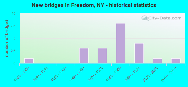
- New bridges - historical statistics
- 11930-1939
- 31960-1969
- 31970-1979
- 81980-1989
- 41990-1999
- 12000-2009
- 12010-2019

- Reconstructed bridges - Historical Statistics
- 11980-1989
- 61990-1999
- 12000-2009
- 22010-2019


- Bridge Condition - Deck
- 10.5%Excellent
- 15.8%Very good
- 47.4%Good
- 15.8%Satisfactory
- 10.5%Fair

- Bridge Condition - Superstructure
- 10.5%Excellent
- 15.8%Very good
- 31.6%Good
- 10.5%Satisfactory
- 21.1%Fair
- 10.5%Poor

- Bridge Condition - Substructure
- 5.3%Excellent
- 10.5%Very good
- 36.8%Good
- 36.8%Satisfactory
- 10.5%Fair

- Bridge Condition - Channel
- 20.0%Very good
- 25.0%Good
- 30.0%Satisfactory
- 20.0%Fair
- 5.0%Poor
Find on map >> Show street view
Structure Number: 103558, Location: .6 MI N JCT SH 98 & SH243 (Lat: 42.443242, Lng: -78.338789), Route carried "on" structure: State highway 98, Year Built: 1988, Status: Open, Structure Length: 4.69m (15.39ft), Average Daily Traffic: 2,427 (year 2020), Truck Traffic: 15%, Average Future Daily Traffic: 2,559 (year 2040), Design Load: HS 20, Features Intersected: RELIEF
Minimum Vertical Clearance: 30+ m (98+ ft), Kilometerpoint: 41.287, Lanes on structure: 2, Base Highway Network: Yes, Owner: State Highway Agency, Approaching Roadway Width: 12.2m (40.0ft), Skew: 3 degrees, Material/Design: Steel, Design/Construction: Stringer/Multi-beam, Number Of Spans In Main Unit: 1, Length of Maximum Span: 45.1m (148.0ft), Curb-To-Curb Width: 12.0m (39.4ft), Out-to-Out Width: 13.0m (42.7ft)
Condition: Deck: Good, Superstructure: Good, Substructure: Very good, Operating Rating: 62.2 metric tons, Method Used To Determine Operating Rating: Load and Resistance Factor Rating (LRFR) rating reported by rating factor(RF) method using HL-93 loadings, Inventory Rating: 48.0 metric tons, Method Used To Determine Inventory Rating: Load and Resistance Factor Rating (LRFR) rating reported by rating factor(RF) method using HL-93 loadings, Structural Evaluation: Better than present minimum criteria, Deck Geometry: Somewhat better than minimum adequacy, Approach Roadway Alignment: Equal to present desirable criteria, Length Of Structure Improvement: 4.69m (15.39ft), Designated Inspection Frequency: Every 24 months, Inspection Date: June 2021, Bridge Improvement Cost: $2,662,000, Roadway Improvement Cost: $1,559,000, Total Project Cost: $4,221,000 ( Estimate for 2021), Deck Structure Type: Concrete Cast-file-Place, Wearing Surface/Protective System: Wearing Surface: Integral Concrete, Deck Protection: Epoxy Coated Reinforcing
Find on map >> Show street view
Structure Number: 103559, Location: 3.2 MI N JCT RTS 98 + 243 (Lat: 42.478328, Lng: -78.346556), Route carried "on" structure: State highway 98, Year Built: 1968, Status: Open, Structure Length: 1.01m (3.31ft), Average Daily Traffic: 2,427 (year 2020), Truck Traffic: 15%, Average Future Daily Traffic: 2,559 (year 2040), Design Load: H 20, Features Intersected: CLEAR CREEK TRIB.
Minimum Vertical Clearance: 30+ m (98+ ft), Kilometerpoint: 45.406, Lanes on structure: 2, Base Highway Network: Yes, Owner: State Highway Agency, Approaching Roadway Width: 12.5m (41.0ft), Skew: 4 degrees, Material/Design: Steel, Design/Construction: Culvert, Number Of Spans In Main Unit: 2, Length of Maximum Span: 4.2m (13.8ft)
Condition: Channel: Good, Culverts: Good, Operating Rating: 72.9 metric tons, Method Used To Determine Operating Rating: Field evaluation and documented engineering judgment, Inventory Rating: 32.7 metric tons, Method Used To Determine Inventory Rating: Field evaluation and documented engineering judgment, Structural Evaluation: Better than present minimum criteria, Waterway Adequacy: Somewhat better than minimum adequacy, Approach Roadway Alignment: Equal to present desirable criteria, Length Of Structure Improvement: 1.00m (3.28ft), Designated Inspection Frequency: Every 24 months, Inspection Date: May 2020, Bridge Improvement Cost: $347,000, Roadway Improvement Cost: $203,000, Total Project Cost: $551,000 ( Estimate for 2021), Wearing Surface/Protective System: Wearing Surface: Bituminous
Find on map >> Show street view
Structure Number: 10356, Location: 3.3 MI N JCT RTS 98 + 243 (Lat: 42.479881, Lng: -78.347039), Route carried "on" structure: State highway 98, Year Built: 1968, Year Reconstructed: 2004, Status: Open, Structure Length: 2.26m (7.41ft), Average Daily Traffic: 2,427 (year 2020), Truck Traffic: 15%, Average Future Daily Traffic: 2,559 (year 2040), Design Load: HS 25 or greater, Features Intersected: CLEAR CREEK
Minimum Vertical Clearance: 30+ m (98+ ft), Kilometerpoint: 45.583, Lanes on structure: 2, Base Highway Network: Yes, Owner: State Highway Agency, Approaching Roadway Width: 11.9m (39.0ft), Material/Design: Steel, Design/Construction: Stringer/Multi-beam, Number Of Spans In Main Unit: 1, Length of Maximum Span: 21.3m (69.9ft), Curb-To-Curb Width: 12.0m (39.4ft), Out-to-Out Width: 13.0m (42.7ft)
Condition: Deck: Good, Superstructure: Very good, Substructure: Good, Channel: Satisfactory, Operating Rating: 56.7 metric tons, Method Used To Determine Operating Rating: Load and Resistance Factor Rating (LRFR) rating reported by rating factor(RF) method using HL-93 loadings, Inventory Rating: 43.7 metric tons, Method Used To Determine Inventory Rating: Load and Resistance Factor Rating (LRFR) rating reported by rating factor(RF) method using HL-93 loadings, Structural Evaluation: Better than present minimum criteria, Deck Geometry: Somewhat better than minimum adequacy, Waterway Adequacy: Meets minimum limits, Approach Roadway Alignment: Equal to present desirable criteria, Length Of Structure Improvement: 2.25m (7.38ft), Designated Inspection Frequency: Every 24 months, Inspection Date: May 2020, Bridge Improvement Cost: $1,302,000, Roadway Improvement Cost: $762,000, Total Project Cost: $2,064,000 ( Estimate for 2021), Deck Structure Type: Concrete Cast-file-Place, Wearing Surface/Protective System: Wearing Surface: Integral Concrete, Deck Protection: Epoxy Coated Reinforcing
Find on map >> Show street view
Structure Number: 103561, Location: 4.6 MI N JCT RTS 98 + 243 (Lat: 42.487903, Lng: -78.368456), Route carried "on" structure: State highway 98, Year Built: 1966, Year Reconstructed: 1995, Status: Open, Structure Length: 2.83m (9.28ft), Average Daily Traffic: 4,011 (year 2020), Truck Traffic: 12%, Average Future Daily Traffic: 4,230 (year 2040), Design Load: HS 25 or greater, Features Intersected: CLEAR CREEK
Minimum Vertical Clearance: 30+ m (98+ ft), Kilometerpoint: 47.642, Lanes on structure: 2, Base Highway Network: Yes, Owner: State Highway Agency, Approaching Roadway Width: 11.0m (36.1ft), Skew: 3 degrees, Material/Design: Steel, Design/Construction: Stringer/Multi-beam, Number Of Spans In Main Unit: 1, Length of Maximum Span: 26.8m (87.9ft), Curb-To-Curb Width: 10.0m (32.8ft), Out-to-Out Width: 10.6m (34.8ft)
Condition: Deck: Very good, Superstructure: Very good, Substructure: Good, Channel: Very good, Operating Rating: 77.1 metric tons, Method Used To Determine Operating Rating: Load Factor (LF), Inventory Rating: 46.3 metric tons, Method Used To Determine Inventory Rating: Load Factor (LF), Structural Evaluation: Better than present minimum criteria, Deck Geometry: Meets minimum limits, Waterway Adequacy: Equal to present minimum criteria, Approach Roadway Alignment: Equal to present desirable criteria, Length Of Structure Improvement: 2.83m (9.28ft), Designated Inspection Frequency: Every 24 months, Inspection Date: July 2020, Bridge Improvement Cost: $1,303,000, Roadway Improvement Cost: $763,000, Total Project Cost: $2,067,000 ( Estimate for 2021), Deck Structure Type: Concrete Cast-file-Place, Wearing Surface/Protective System: Wearing Surface: Monolithic Concrete, Deck Protection: Epoxy Coated Reinforcing
Find on map >> Show street view
Structure Number: 332151, Location: 1.3 MILES NW OF ELTON (Lat: 42.463789, Lng: -78.444839), Route carried "on" structure: County highway , Year Built: 1973, Year Reconstructed: 1990, Status: Open, Structure Length: 2.29m (7.51ft), Average Daily Traffic: 407 (year 2016), Truck Traffic: 21%, Average Future Daily Traffic: 570 (year 2036), Design Load: H 20, Features Intersected: S BR ELTON CREEK, Facility Carried by Structure: COUNTY ROAD 21
Minimum Vertical Clearance: 30+ m (98+ ft), Kilometerpoint: 3.459, Lanes on structure: 2, Owner: County Highway Agency, Approaching Roadway Width: 6.1m (20.0ft), Skew: 6 degrees, Material/Design: Steel, Design/Construction: Stringer/Multi-beam, Number Of Spans In Main Unit: 1, Length of Maximum Span: 22.2m (72.8ft), Curb-To-Curb Width: 7.7m (25.3ft), Out-to-Out Width: 8.1m (26.6ft)
Condition: Deck: Good, Superstructure: Satisfactory, Substructure: Fair, Channel: Satisfactory, Operating Rating: 59.9 metric tons, Method Used To Determine Operating Rating: Load Factor (LF), Inventory Rating: 36.3 metric tons, Method Used To Determine Inventory Rating: Load Factor (LF), Structural Evaluation: Somewhat better than minimum adequacy, Deck Geometry: Meets minimum limits, Waterway Adequacy: Equal to present desirable criteria, Approach Roadway Alignment: Equal to present desirable criteria, Length Of Structure Improvement: 2.28m (7.48ft), Designated Inspection Frequency: Every 24 months, Inspection Date: April 2020, Bridge Improvement Cost: $1,354,000, Roadway Improvement Cost: $793,000, Total Project Cost: $2,148,000 ( Estimate for 2021), Deck Structure Type: Wood or Timber, Wearing Surface/Protective System: Wearing Surface: Bituminous, Membrane: Other
Find on map >> Show street view
Structure Number: 332152, Location: 1.1 MILES NW OF ELTON (Lat: 42.462503, Lng: -78.443478), Route carried "on" structure: County highway , Year Built: 1988, Year Reconstructed: 1990, Status: Open, Structure Length: 0.76m (2.49ft), Average Daily Traffic: 407 (year 2016), Truck Traffic: 21%, Average Future Daily Traffic: 570 (year 2036), Features Intersected: TRIB ELTON CREEK, Facility Carried by Structure: COUNTY ROAD 21
Minimum Vertical Clearance: 30+ m (98+ ft), Kilometerpoint: 3.669, Lanes on structure: 2, Owner: County Highway Agency, Approaching Roadway Width: 7.3m (24.0ft), Skew: 1 degrees, Material/Design: Steel, Design/Construction: Stringer/Multi-beam, Number Of Spans In Main Unit: 1, Length of Maximum Span: 7.3m (24.0ft), Curb-To-Curb Width: 7.8m (25.6ft), Out-to-Out Width: 8.0m (26.2ft)
Condition: Deck: Good, Superstructure: Fair, Substructure: Satisfactory, Channel: Fair, Operating Rating: 60.8 metric tons, Method Used To Determine Operating Rating: Load Factor (LF), Inventory Rating: 36.3 metric tons, Method Used To Determine Inventory Rating: Load Factor (LF), Structural Evaluation: Somewhat better than minimum adequacy, Deck Geometry: Meets minimum limits, Waterway Adequacy: Equal to present desirable criteria, Approach Roadway Alignment: Equal to present desirable criteria, Length Of Structure Improvement: 0.76m (2.49ft), Designated Inspection Frequency: Every 24 months, Inspection Date: April 2020, Bridge Improvement Cost: $389,000, Roadway Improvement Cost: $228,000, Total Project Cost: $616,000 ( Estimate for 2021), Deck Structure Type: Wood or Timber, Wearing Surface/Protective System: Wearing Surface: Bituminous
Find on map >> Show street view
Structure Number: 332153, Location: .4 MILE NW OF ELTON (Lat: 42.452136, Lng: -78.437067), Route carried "on" structure: County highway , Year Built: 1993, Status: Open, Structure Length: 2.87m (9.42ft), Average Daily Traffic: 407 (year 2016), Truck Traffic: 21%, Average Future Daily Traffic: 570 (year 2036), Design Load: HS 25 or greater, Features Intersected: S BR ELTON CREEK, Quarry, Facility Carried by Structure: COUNTY ROAD 21
Minimum Vertical Clearance: 6.38m (20.93ft), Kilometerpoint: 4.940, Lanes on structure: 2, Owner: County Highway Agency, Approaching Roadway Width: 8.5m (27.9ft), Skew: 4 degrees, Material/Design: Steel, Design/Construction: Stringer/Multi-beam, Number Of Spans In Main Unit: 1, Length of Maximum Span: 28.3m (92.8ft), Curb-To-Curb Width: 9.4m (30.8ft), Out-to-Out Width: 10.1m (33.1ft)
Condition: Deck: Good, Superstructure: Good, Substructure: Good, Channel: Satisfactory, Operating Rating: 47.3 metric tons, Method Used To Determine Operating Rating: Load and Resistance Factor Rating (LRFR) rating reported by rating factor(RF) method using HL-93 loadings, Inventory Rating: 36.6 metric tons, Method Used To Determine Inventory Rating: Load and Resistance Factor Rating (LRFR) rating reported by rating factor(RF) method using HL-93 loadings, Structural Evaluation: Better than present minimum criteria, Deck Geometry: Equal to present minimum criteria, Waterway Adequacy: Somewhat better than minimum adequacy, Approach Roadway Alignment: Equal to present desirable criteria, Length Of Structure Improvement: 2.86m (9.38ft), Designated Inspection Frequency: Every 24 months, Inspection Date: April 2021, Bridge Improvement Cost: $1,429,000, Roadway Improvement Cost: $837,000, Total Project Cost: $2,266,000 ( Estimate for 2021), Deck Structure Type: Concrete Cast-file-Place, Wearing Surface/Protective System: Wearing Surface: Integral Concrete, Deck Protection: Epoxy Coated Reinforcing
Find on map >> Show street view
Structure Number: 332154, Location: .2 MILE WEST OF ELTON (Lat: 42.449772, Lng: -78.432069), Route carried "on" structure: County highway , Year Built: 1989, Year Reconstructed: 2019, Status: Open, Structure Length: 3.41m (11.19ft), Average Daily Traffic: 740 (year 2017), Truck Traffic: 17%, Average Future Daily Traffic: 1,036 (year 2037), Design Load: HS 20, Features Intersected: ELTON CREEK, Facility Carried by Structure: COUNTY ROAD 21
Minimum Vertical Clearance: 30+ m (98+ ft), Kilometerpoint: 5.406, Lanes on structure: 2, Owner: County Highway Agency, Approaching Roadway Width: 9.1m (29.9ft), Skew: 4 degrees, Material/Design: Prestressed concrete, Design/Construction: Box Beam or Girders - Multiple, Number Of Spans In Main Unit: 1, Length of Maximum Span: 33.5m (109.9ft), Curb-To-Curb Width: 8.9m (29.2ft), Out-to-Out Width: 10.3m (33.8ft)
Condition: Deck: Excellent, Superstructure: Satisfactory, Substructure: Good, Channel: Very good, Operating Rating: 81.6 metric tons, Method Used To Determine Operating Rating: Load Factor (LF), Inventory Rating: 31.8 metric tons, Method Used To Determine Inventory Rating: Load Factor (LF), Structural Evaluation: Equal to present minimum criteria, Deck Geometry: Somewhat better than minimum adequacy, Waterway Adequacy: Equal to present desirable criteria, Approach Roadway Alignment: Equal to present desirable criteria, Length Of Structure Improvement: 3.41m (11.19ft), Designated Inspection Frequency: Every 24 months, Inspection Date: April 2020, Bridge Improvement Cost: $1,201,000, Roadway Improvement Cost: $703,000, Total Project Cost: $1,905,000 ( Estimate for 2021), Deck Structure Type: Concrete Cast-file-Place, Wearing Surface/Protective System: Wearing Surface: Integral Concrete, Deck Protection: Epoxy Coated Reinforcing
Find on map >> Show street view
Structure Number: 332155, Location: .1 MILE SOUTH OF ELTON (Lat: 42.448547, Lng: -78.428542), Route carried "on" structure: County highway , Year Built: 1978, Status: Open, Structure Length: 3.72m (12.20ft), Average Daily Traffic: 962 (year 2018), Truck Traffic: 11%, Average Future Daily Traffic: 971 (year 2040), Design Load: HS 20, Features Intersected: ELTON CREEK, Facility Carried by Structure: PIGEON HILL ROAD
Minimum Vertical Clearance: 30+ m (98+ ft), Kilometerpoint: 5.857, Lanes on structure: 2, Owner: County Highway Agency, Approaching Roadway Width: 10.4m (34.1ft), Material/Design: Steel, Design/Construction: Stringer/Multi-beam, Number Of Spans In Main Unit: 1, Length of Maximum Span: 36.5m (119.8ft), Curb-To-Curb Width: 10.4m (34.1ft), Out-to-Out Width: 11.0m (36.1ft)
Condition: Deck: Satisfactory, Superstructure: Good, Substructure: Good, Channel: Good, Operating Rating: 87.1 metric tons, Method Used To Determine Operating Rating: Load Factor (LF), Inventory Rating: 51.7 metric tons, Method Used To Determine Inventory Rating: Load Factor (LF), Structural Evaluation: Better than present minimum criteria, Deck Geometry: Equal to present minimum criteria, Waterway Adequacy: Somewhat better than minimum adequacy, Approach Roadway Alignment: Equal to present desirable criteria, Length Of Structure Improvement: 3.71m (12.17ft), Designated Inspection Frequency: Every 24 months, Inspection Date: April 2021, Bridge Improvement Cost: $1,743,000, Roadway Improvement Cost: $1,021,000, Total Project Cost: $2,764,000 ( Estimate for 2021), Deck Structure Type: Concrete Cast-file-Place, Wearing Surface/Protective System: Wearing Surface: Integral Concrete, Deck Protection: Epoxy Coated Reinforcing
Find on map >> Show street view
Structure Number: 332156, Location: .8 MILE SE OF ELTON (Lat: 42.441492, Lng: -78.417347), Route carried "on" structure: County highway , Year Built: 2001, Status: Open, Structure Length: 2.99m (9.81ft), Average Daily Traffic: 378 (year 2017), Truck Traffic: 6%, Average Future Daily Traffic: 529 (year 2037), Design Load: HS 25 or greater, Features Intersected: ELTON CREEK, Facility Carried by Structure: COUNTY ROAD 21
Minimum Vertical Clearance: 30+ m (98+ ft), Kilometerpoint: 7.546, Lanes on structure: 2, Owner: County Highway Agency, Approaching Roadway Width: 9.1m (29.9ft), Skew: 1 degrees, Material/Design: Prestressed concrete, Design/Construction: Box Beam or Girders - Multiple, Number Of Spans In Main Unit: 1, Length of Maximum Span: 29.0m (95.1ft), Curb-To-Curb Width: 9.0m (29.5ft), Out-to-Out Width: 10.2m (33.5ft)
Condition: Deck: Good, Superstructure: Very good, Substructure: Very good, Channel: Very good, Operating Rating: 98.0 metric tons, Method Used To Determine Operating Rating: Load Factor (LF), Inventory Rating: 56.2 metric tons, Method Used To Determine Inventory Rating: Load Factor (LF), Structural Evaluation: Equal to present desirable criteria, Deck Geometry: Equal to present minimum criteria, Waterway Adequacy: Equal to present minimum criteria, Approach Roadway Alignment: Equal to present desirable criteria, Length Of Structure Improvement: 2.98m (9.78ft), Designated Inspection Frequency: Every 24 months, Inspection Date: July 2021, Bridge Improvement Cost: $760,000, Roadway Improvement Cost: $445,000, Total Project Cost: $1,205,000 ( Estimate for 2021), Deck Structure Type: Concrete Cast-file-Place, Wearing Surface/Protective System: Wearing Surface: Monolithic Concrete, Deck Protection: Epoxy Coated Reinforcing
Find on map >> Show street view
Structure Number: 332157, Location: .6 MILE EAST OF FREEDOM (Lat: 42.485219, Lng: -78.319992), Route carried "on" structure: County highway , Year Built: 1995, Status: Open, Structure Length: 1.22m (4.00ft), Average Daily Traffic: 972 (year 2017), Truck Traffic: 9%, Average Future Daily Traffic: 981 (year 2040), Design Load: HS 25 or greater, Features Intersected: CLEAR CREEK, Facility Carried by Structure: FREEDOM ROAD
Minimum Vertical Clearance: 30+ m (98+ ft), Kilometerpoint: 2.397, Lanes on structure: 2, Owner: County Highway Agency, Approaching Roadway Width: 9.1m (29.9ft), Skew: 1 degrees, Material/Design: Steel, Design/Construction: Stringer/Multi-beam, Number Of Spans In Main Unit: 1, Length of Maximum Span: 11.5m (37.7ft), Curb-To-Curb Width: 9.2m (30.2ft), Out-to-Out Width: 9.9m (32.5ft)
Condition: Deck: Satisfactory, Superstructure: Good, Substructure: Satisfactory, Channel: Good, Operating Rating: 60.6 metric tons, Method Used To Determine Operating Rating: Load and Resistance Factor Rating (LRFR) rating reported by rating factor(RF) method using HL-93 loadings, Inventory Rating: 46.7 metric tons, Method Used To Determine Inventory Rating: Load and Resistance Factor Rating (LRFR) rating reported by rating factor(RF) method using HL-93 loadings, Structural Evaluation: Equal to present minimum criteria, Deck Geometry: Equal to present minimum criteria, Waterway Adequacy: Somewhat better than minimum adequacy, Approach Roadway Alignment: Better than present minimum criteria, Length Of Structure Improvement: 1.21m (3.97ft), Designated Inspection Frequency: Every 24 months, Inspection Date: March 2021, Bridge Improvement Cost: $1,020,000, Roadway Improvement Cost: $597,000, Total Project Cost: $1,617,000 ( Estimate for 2021), Deck Structure Type: Concrete Precast Panels, Wearing Surface/Protective System: Wearing Surface: Bituminous, Membrane: Other
Find on map >> Show street view
Structure Number: 332158, Location: .1 MILE WEST OF FREEDOM (Lat: 42.484508, Lng: -78.332225), Route carried "on" structure: County highway , Year Built: 1989, Status: Open, Structure Length: 1.40m (4.59ft), Average Daily Traffic: 1,056 (year 2017), Truck Traffic: 11%, Average Future Daily Traffic: 1,066 (year 2040), Features Intersected: CLEAR CREEK, Facility Carried by Structure: FREEDOM ROAD
Minimum Vertical Clearance: 30+ m (98+ ft), Kilometerpoint: 1.384, Lanes on structure: 2, Owner: County Highway Agency, Approaching Roadway Width: 6.4m (21.0ft), Skew: 4 degrees, Material/Design: Steel, Design/Construction: Stringer/Multi-beam, Number Of Spans In Main Unit: 1, Length of Maximum Span: 13.1m (43.0ft), Curb-To-Curb Width: 7.7m (25.3ft), Out-to-Out Width: 7.8m (25.6ft)
Condition: Deck: Good, Superstructure: Good, Substructure: Good, Channel: Good, Operating Rating: 33.7 metric tons, Method Used To Determine Operating Rating: Load and Resistance Factor Rating (LRFR) rating reported by rating factor(RF) method using HL-93 loadings, Inventory Rating: 25.9 metric tons, Method Used To Determine Inventory Rating: Load and Resistance Factor Rating (LRFR) rating reported by rating factor(RF) method using HL-93 loadings, Structural Evaluation: Equal to present minimum criteria, Deck Geometry: Meets minimum limits, Waterway Adequacy: Meets minimum limits, Approach Roadway Alignment: Equal to present desirable criteria, Length Of Structure Improvement: 1.40m (4.59ft), Designated Inspection Frequency: Every 24 months, Inspection Date: March 2021, Bridge Improvement Cost: $1,483,000, Roadway Improvement Cost: $868,000, Total Project Cost: $2,351,000 ( Estimate for 2021), Deck Structure Type: Wood or Timber, Wearing Surface/Protective System: Wearing Surface: Bituminous, Membrane: Other
Find on map >> Show street view
Structure Number: 332159, Location: 0.5 MI W OF FREEDOM (Lat: 42.483800, Lng: -78.340181), Route carried "on" structure: County highway , Year Built: 2015, Status: Open, Structure Length: 2.01m (6.59ft), Average Daily Traffic: 1,047 (year 2017), Truck Traffic: 10%, Average Future Daily Traffic: 1,057 (year 2040), Design Load: HS 25 or greater, Features Intersected: CLEAR CREEK, Facility Carried by Structure: FREEDOM ROAD
Minimum Vertical Clearance: 30+ m (98+ ft), Kilometerpoint: 0.724, Lanes on structure: 2, Owner: County Highway Agency, Approaching Roadway Width: 6.1m (20.0ft), Skew: 3 degrees, Material/Design: Steel, Design/Construction: Stringer/Multi-beam, Number Of Spans In Main Unit: 1, Length of Maximum Span: 19.8m (65.0ft), Curb-To-Curb Width: 8.5m (27.9ft), Out-to-Out Width: 9.5m (31.2ft)
Condition: Deck: Excellent, Superstructure: Excellent, Substructure: Excellent, Channel: Very good, Inventory Rating: 71.7 metric tons, Method Used To Determine Inventory Rating: Load Factor (LF), Structural Evaluation: Superior to present desirable criteria, Deck Geometry: Somewhat better than minimum adequacy, Waterway Adequacy: Equal to present minimum criteria, Approach Roadway Alignment: Better than present minimum criteria, Length Of Structure Improvement: 2.01m (6.59ft), Designated Inspection Frequency: Every 24 months, Inspection Date: October 2021, Bridge Improvement Cost: $920,000, Roadway Improvement Cost: $539,000, Total Project Cost: $1,459,000 ( Estimate for 2021), Deck Structure Type: Concrete Cast-file-Place, Wearing Surface/Protective System: Wearing Surface: Integral Concrete, Deck Protection: Epoxy Coated Reinforcing
Find on map >> Show street view
Structure Number: 332162, Location: 4 MILES NE OF DELEVAN (Lat: 42.519639, Lng: -78.402264), Route carried "on" structure: Other road , Year Built: 1970, Year Reconstructed: 1993, Status: Open, Structure Length: 2.87m (9.42ft), Average Daily Traffic: 538 (year 2018), Truck Traffic: 9%, Average Future Daily Traffic: 753 (year 2038), Design Load: H 20, Features Intersected: CLEAR CREEK, Facility Carried by Structure: BRAY ROAD
Minimum Vertical Clearance: 30+ m (98+ ft), Kilometerpoint: 0.161, Lanes on structure: 2, Owner: County Highway Agency, Approaching Roadway Width: 5.5m (18.0ft), Skew: 4 degrees, Material/Design: Steel, Design/Construction: Truss - Thru, Number Of Spans In Main Unit: 1, Length of Maximum Span: 28.0m (91.9ft), Curb-To-Curb Width: 7.3m (24.0ft), Out-to-Out Width: 7.7m (25.3ft)
Condition: Deck: Very good, Superstructure: Fair, Substructure: Fair, Channel: Good, Operating Rating: 46.3 metric tons, Method Used To Determine Operating Rating: Load Factor (LF), Inventory Rating: 27.2 metric tons, Method Used To Determine Inventory Rating: Load Factor (LF), Structural Evaluation: Somewhat better than minimum adequacy, Deck Geometry: Meets minimum limits, Waterway Adequacy: Meets minimum limits, Approach Roadway Alignment: Equal to present desirable criteria, Length Of Structure Improvement: 2.86m (9.38ft), Designated Inspection Frequency: Every 24 months, Critical Feature Inspection Frequency: Every 24 months, Inspection Date: August 2021, Critical Feature Inspection Date: August 2021, Bridge Improvement Cost: $2,344,000, Roadway Improvement Cost: $1,373,000, Total Project Cost: $3,717,000 ( Estimate for 2021), Deck Structure Type: Wood or Timber, Wearing Surface/Protective System: Wearing Surface: Bituminous, Membrane: Other
Find on map >> Show street view
Structure Number: 332163, Location: 0.4 MI N OF SANDUSKY (Lat: 42.501081, Lng: -78.384481), Route carried "on" structure: Other road , Year Built: 1997, Status: Open, Structure Length: 1.83m (6.00ft), Average Daily Traffic: 34 (year 2019), Truck Traffic: 5%, Average Future Daily Traffic: 48 (year 2039), Design Load: HS 20, Features Intersected: CLEAR CREEK, Facility Carried by Structure: JONES ROAD
Minimum Vertical Clearance: 30+ m (98+ ft), Kilometerpoint: 0.209, Lanes on structure: 2, Owner: County Highway Agency, Approaching Roadway Width: 6.7m (22.0ft), Material/Design: Steel, Design/Construction: Stringer/Multi-beam, Number Of Spans In Main Unit: 1, Length of Maximum Span: 17.9m (58.7ft), Curb-To-Curb Width: 5.5m (18.0ft), Out-to-Out Width: 6.1m (20.0ft)
Condition: Deck: Good, Superstructure: Good, Substructure: Good, Channel: Fair, Operating Rating: 64.4 metric tons, Method Used To Determine Operating Rating: Load Factor (LF), Inventory Rating: 39.0 metric tons, Method Used To Determine Inventory Rating: Load Factor (LF), Structural Evaluation: Better than present minimum criteria, Deck Geometry: Meets minimum limits, Waterway Adequacy: Equal to present desirable criteria, Approach Roadway Alignment: Equal to present desirable criteria, Length Of Structure Improvement: 1.82m (5.97ft), Designated Inspection Frequency: Every 24 months, Inspection Date: April 2020, Bridge Improvement Cost: $1,028,000, Roadway Improvement Cost: $602,000, Total Project Cost: $1,630,000 ( Estimate for 2021), Deck Structure Type: Concrete Precast Panels, Wearing Surface/Protective System: Wearing Surface: Other
Find on map >> Show street view
Structure Number: 332164, Location: 3.3 MI NW OF FREEDOM (Lat: 42.504958, Lng: -78.387881), Route carried "on" structure: Other road , Year Built: 1983, Year Reconstructed: 2013, Status: Open, Structure Length: 2.19m (7.19ft), Average Daily Traffic: 287 (year 2020), Truck Traffic: 5%, Average Future Daily Traffic: 402 (year 2040), Features Intersected: CLEAR CREEK, Facility Carried by Structure: SPARKS ROAD
Minimum Vertical Clearance: 30+ m (98+ ft), Kilometerpoint: 0.306, Lanes on structure: 2, Owner: County Highway Agency, Approaching Roadway Width: 5.5m (18.0ft), Skew: 1 degrees, Material/Design: Steel, Design/Construction: Stringer/Multi-beam, Number Of Spans In Main Unit: 2, Length of Maximum Span: 10.6m (34.8ft), Curb-To-Curb Width: 7.9m (25.9ft), Out-to-Out Width: 7.9m (25.9ft)
Condition: Deck: Very good, Superstructure: Fair, Substructure: Satisfactory, Channel: Poor, Operating Rating: 32.7 metric tons, Method Used To Determine Operating Rating: Load Factor (LF), Inventory Rating: 19.1 metric tons, Method Used To Determine Inventory Rating: Load Factor (LF), Structural Evaluation: Somewhat better than minimum adequacy, Deck Geometry: Somewhat better than minimum adequacy, Waterway Adequacy: Meets minimum limits, Approach Roadway Alignment: Meets minimum limits, Length Of Structure Improvement: 2.19m (7.19ft), Designated Inspection Frequency: Every 24 months, Inspection Date: June 2021, Bridge Improvement Cost: $1,203,000, Roadway Improvement Cost: $705,000, Total Project Cost: $1,908,000 ( Estimate for 2021), Deck Structure Type: Open Grating, Wearing Surface/Protective System: Wearing Surface: Other
Find on map >> Show street view
Structure Number: 332165, Location: 2.8 MI NW OF FREEDOM (Lat: 42.496075, Lng: -78.383378), Route carried "on" structure: Other road , Year Built: 1980, Year Reconstructed: 2002, Status: Posted for load-capacity, Structure Length: 1.65m (5.41ft), Average Daily Traffic: 771 (year 2020), Truck Traffic: 8%, Average Future Daily Traffic: 1,079 (year 2040), Design Load: HS 20, Features Intersected: CLEAR CREEK, Facility Carried by Structure: EAGLE STREET
Minimum Vertical Clearance: 30+ m (98+ ft), Kilometerpoint: 0.080, Lanes on structure: 2, Owner: County Highway Agency, Approaching Roadway Width: 6.4m (21.0ft), Material/Design: Steel, Design/Construction: Stringer/Multi-beam, Number Of Spans In Main Unit: 1, Length of Maximum Span: 16.1m (52.8ft), Curb-To-Curb Width: 7.8m (25.6ft), Out-to-Out Width: 8.3m (27.2ft)
Condition: Deck: Fair, Superstructure: Fair, Substructure: Satisfactory, Channel: Satisfactory, Operating Rating: 7.5 metric tons, Method Used To Determine Operating Rating: Load and Resistance Factor Rating (LRFR) rating reported by rating factor(RF) method using HL-93 loadings, Inventory Rating: 5.5 metric tons, Method Used To Determine Inventory Rating: Load and Resistance Factor Rating (LRFR) rating reported by rating factor(RF) method using HL-93 loadings, Structural Evaluation: High priority of corrective action, Deck Geometry: Meets minimum limits, Waterway Adequacy: Meets minimum limits, Approach Roadway Alignment: Equal to present desirable criteria, Length Of Structure Improvement: 1.64m (5.38ft), Designated Inspection Frequency: Every 24 months, Inspection Date: April 2021, Bridge Improvement Cost: $1,285,000, Roadway Improvement Cost: $752,000, Total Project Cost: $2,037,000 ( Estimate for 2021), Deck Structure Type: Corrugated Steel, Wearing Surface/Protective System: Wearing Surface: Bituminous
Find on map >> Show street view
Structure Number: 332166, Location: 1.5 MI W OF FREEDOM (Lat: 42.485500, Lng: -78.358731), Route carried "on" structure: Other road , Year Built: 1980, Status: Open, Structure Length: 1.68m (5.51ft), Average Daily Traffic: 247 (year 2017), Truck Traffic: 11%, Average Future Daily Traffic: 346 (year 2037), Design Load: HS 20, Features Intersected: CLEAR CREEK, Facility Carried by Structure: GALEN HILL ROAD
Minimum Vertical Clearance: 30+ m (98+ ft), Kilometerpoint: 5.455, Lanes on structure: 2, Owner: County Highway Agency, Approaching Roadway Width: 6.7m (22.0ft), Material/Design: Steel, Design/Construction: Stringer/Multi-beam, Number Of Spans In Main Unit: 1, Length of Maximum Span: 16.4m (53.8ft), Curb-To-Curb Width: 7.8m (25.6ft), Out-to-Out Width: 8.0m (26.2ft)
Condition: Deck: Good, Superstructure: Poor, Substructure: Satisfactory, Channel: Fair, Operating Rating: 27.5 metric tons, Method Used To Determine Operating Rating: Load and Resistance Factor Rating (LRFR) rating reported by rating factor(RF) method using HL-93 loadings, Inventory Rating: 21.4 metric tons, Method Used To Determine Inventory Rating: Load and Resistance Factor Rating (LRFR) rating reported by rating factor(RF) method using HL-93 loadings, Structural Evaluation: Meets minimum limits, Deck Geometry: Somewhat better than minimum adequacy, Waterway Adequacy: Meets minimum limits, Approach Roadway Alignment: Equal to present desirable criteria, Length Of Structure Improvement: 1.67m (5.48ft), Designated Inspection Frequency: Every 24 months, Inspection Date: April 2021, Bridge Improvement Cost: $1,255,000, Roadway Improvement Cost: $735,000, Total Project Cost: $1,989,000 ( Estimate for 2021), Deck Structure Type: Open Grating, Wearing Surface/Protective System: Wearing Surface: Other
Find on map >> Show street view
Structure Number: 332167, Location: 0.7 MI. 0F FREEDOM (Lat: 42.488956, Lng: -78.318867), Route carried "on" structure: Other road , Year Built: 1990, Status: Open, Structure Length: 0.67m (2.20ft), Average Daily Traffic: 85 (year 2017), Truck Traffic: 5%, Average Future Daily Traffic: 119 (year 2037), Design Load: HS 20, Features Intersected: BR CLEAR CREEK, Facility Carried by Structure: DOW ROAD
Minimum Vertical Clearance: 30+ m (98+ ft), Kilometerpoint: 0.177, Lanes on structure: 2, Owner: County Highway Agency, Approaching Roadway Width: 5.8m (19.0ft), Skew: 2 degrees, Material/Design: Concrete, Design/Construction: Culvert, Number Of Spans In Main Unit: 2, Length of Maximum Span: 2.7m (8.9ft)
Condition: Channel: Fair, Culverts: Good, Operating Rating: 75.3 metric tons, Method Used To Determine Operating Rating: Load Factor (LF), Inventory Rating: 44.5 metric tons, Method Used To Determine Inventory Rating: Load Factor (LF), Structural Evaluation: Better than present minimum criteria, Waterway Adequacy: Meets minimum limits, Approach Roadway Alignment: Equal to present desirable criteria, Length Of Structure Improvement: 0.67m (2.20ft), Designated Inspection Frequency: Every 24 months, Inspection Date: April 2021, Bridge Improvement Cost: $107,000, Roadway Improvement Cost: $63,000, Total Project Cost: $170,000 ( Estimate for 2021)
Find on map >> Show street view
Structure Number: 332168, Location: .4 MILE EAST OF FREEDOM (Lat: 42.484772, Lng: -78.323247), Route carried "on" structure: Other road , Year Built: 1981, Year Reconstructed: 1997, Status: Posted for load, Structure Length: 0.91m (2.99ft), Average Daily Traffic: 40 (year 2017), Truck Traffic: 5%, Average Future Daily Traffic: 56 (year 2037), Design Load: HS 20, Features Intersected: TRIB CLEAR CREEK, Facility Carried by Structure: WITT ROAD
Minimum Vertical Clearance: 30+ m (98+ ft), Kilometerpoint: 0.708, Lanes on structure: 2, Owner: County Highway Agency, Approaching Roadway Width: 6.1m (20.0ft), Material/Design: Steel, Design/Construction: Stringer/Multi-beam, Number Of Spans In Main Unit: 1, Length of Maximum Span: 8.8m (28.9ft), Curb-To-Curb Width: 7.2m (23.6ft), Out-to-Out Width: 7.6m (24.9ft)
Condition: Deck: Fair, Superstructure: Poor, Substructure: Satisfactory, Channel: Satisfactory, Operating Rating: 23.6 metric tons, Method Used To Determine Operating Rating: Load Factor (LF), Inventory Rating: 13.6 metric tons, Method Used To Determine Inventory Rating: Load Factor (LF), Structural Evaluation: Meets minimum limits, Deck Geometry: Somewhat better than minimum adequacy, Waterway Adequacy: Equal to present desirable criteria, Approach Roadway Alignment: Equal to present desirable criteria, Bridge Posting: Required (Relationship of Operating Rating to Maximum Legal Load: > 39.9% below), Length Of Structure Improvement: 0.91m (2.99ft), Designated Inspection Frequency: Every 12 months, Inspection Date: April 2021, Bridge Improvement Cost: $815,000, Roadway Improvement Cost: $477,000, Total Project Cost: $1,293,000 ( Estimate for 2021), Deck Structure Type: Wood or Timber, Wearing Surface/Protective System: Wearing Surface: Bituminous
Find on map >> Show street view
Structure Number: 332336, Location: AT FREEDOM (Lat: 42.483739, Lng: -78.329783), Route carried "on" structure: Other road , Year Built: 1939, Year Reconstructed: 2018, Status: Open, Structure Length: 1.46m (4.79ft), Average Daily Traffic: 14 (year 2018), Average Future Daily Traffic: 20 (year 2038), Design Load: H 20, Features Intersected: CLEAR CREEK, Facility Carried by Structure: DEPOT STREET
Minimum Vertical Clearance: 30+ m (98+ ft), Kilometerpoint: 0.080, Lanes on structure: 1, Owner: County Highway Agency, Approaching Roadway Width: 3.7m (12.1ft), Material/Design: Steel, Design/Construction: Stringer/Multi-beam, Number Of Spans In Main Unit: 1, Length of Maximum Span: 14.0m (45.9ft), Curb-To-Curb Width: 5.0m (16.4ft), Out-to-Out Width: 5.2m (17.1ft)
Condition: Deck: Satisfactory, Superstructure: Excellent, Substructure: Satisfactory, Channel: Satisfactory, Operating Rating: 43.5 metric tons, Method Used To Determine Operating Rating: Load Factor (LF), Inventory Rating: 25.4 metric tons, Method Used To Determine Inventory Rating: Load Factor (LF), Structural Evaluation: Equal to present minimum criteria, Deck Geometry: High priority of corrective action, Waterway Adequacy: Meets minimum limits, Approach Roadway Alignment: Equal to present desirable criteria, Length Of Structure Improvement: 1.46m (4.79ft), Designated Inspection Frequency: Every 24 months, Inspection Date: May 2021, Bridge Improvement Cost: $329,000, Roadway Improvement Cost: $193,000, Total Project Cost: $522,000 ( Estimate for 2021), Deck Structure Type: Wood or Timber, Wearing Surface/Protective System: Wearing Surface: Wood or Timber