Bridge Statistics for Friendship, Tennessee (TN)
Condition, Traffic, Stress, Structural Evaluation, Project Costs
- National Bridge Inventory (NBI) Statistics
- 41Number of bridges
- 190ft / 57.8mTotal length
- $4,808,000Total costs
- 69,672Total average daily traffic
- 7,196Total average daily truck traffic
- National Bridge Inventory (NBI) Registered Bridges for Friendship
- No street view available for this location
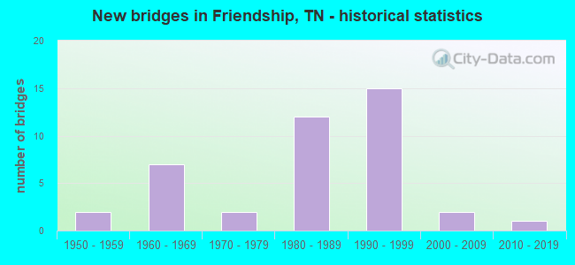
- New bridges - historical statistics
- 21950-1959
- 71960-1969
- 21970-1979
- 121980-1989
- 151990-1999
- 22000-2009
- 12010-2019


- Bridge Condition - Deck
- 6.3%Very good
- 68.8%Good
- 25.0%Satisfactory

- Bridge Condition - Superstructure
- 12.5%Very good
- 56.3%Good
- 25.0%Satisfactory
- 6.3%Fair

- Bridge Condition - Substructure
- 6.3%Very good
- 31.3%Good
- 37.5%Satisfactory
- 18.8%Fair
- 6.3%Poor

- Bridge Condition - Channel
- 23.1%Good
- 76.9%Satisfactory

- Bridge Condition - Culverts
- 20.8%Good
- 66.7%Satisfactory
- 12.5%Fair
Find on map >> Show street view
Structure Number: 17008250001, Location: 2.6 MI NW JCT SR20&SR189 (Lat: 35.925083, Lng: -89.235583), Route carried "on" structure: City street 825, Year Built: 1985, Status: Open, Structure Length: 0.79m (2.59ft), Average Daily Traffic: 341 (year 2020), Truck Traffic: 3%, Average Future Daily Traffic: 864 (year 2040), Design Load: HS 20, Features Intersected: BRANCH
Minimum Vertical Clearance: 30+ m (98+ ft), Kilometerpoint: 0.418, Lanes on structure: 2, Owner: City or Municipal Highway Agency, Approaching Roadway Width: 9.8m (32.2ft), Skew: 4 degrees, Material/Design: Concrete continuous, Design/Construction: Culvert, Number Of Spans In Main Unit: 2, Length of Maximum Span: 2.4m (7.9ft)
Condition: Channel: Satisfactory, Culverts: Satisfactory, Operating Rating: 54.0 metric tons, Method Used To Determine Operating Rating: Field evaluation and documented engineering judgment, Inventory Rating: 32.4 metric tons, Method Used To Determine Inventory Rating: Field evaluation and documented engineering judgment, Structural Evaluation: Equal to present minimum criteria, Waterway Adequacy: Equal to present minimum criteria, Approach Roadway Alignment: Equal to present desirable criteria, Designated Inspection Frequency: Every 24 months, Inspection Date: April 2020
Find on map >> Show street view
Structure Number: 17014960001, Location: 0.5 MI E OF DYER CO (Lat: 35.961222, Lng: -89.201611), Route carried "on" structure: County highway 1496, Year Built: 1992, Status: Open, Structure Length: 1.46m (4.79ft), Average Daily Traffic: 232 (year 2020), Truck Traffic: 3%, Average Future Daily Traffic: 384 (year 2038), Design Load: HS 20, Features Intersected: STOKES CREEK
Minimum Vertical Clearance: 30+ m (98+ ft), Kilometerpoint: 0.515, Lanes on structure: 2, Owner: County Highway Agency, Approaching Roadway Width: 7.9m (25.9ft), Skew: 1 degrees, Material/Design: Concrete continuous, Design/Construction: Culvert, Number Of Spans In Main Unit: 3, Length of Maximum Span: 4.3m (14.1ft), Curb-To-Curb Width: 7.7m (25.3ft), Out-to-Out Width: 8.8m (28.9ft)
Condition: Channel: Satisfactory, Culverts: Good, Operating Rating: 89.1 metric tons, Method Used To Determine Operating Rating: Load Factor (LF), Inventory Rating: 32.4 metric tons, Method Used To Determine Inventory Rating: Load Factor (LF), Structural Evaluation: Better than present minimum criteria, Deck Geometry: Somewhat better than minimum adequacy, Waterway Adequacy: Equal to present minimum criteria, Approach Roadway Alignment: Equal to present minimum criteria, Designated Inspection Frequency: Every 24 months, Inspection Date: April 2020, Deck Structure Type: Concrete Cast-file-Place, Wearing Surface/Protective System: Wearing Surface: Monolithic Concrete, Deck Protection: Epoxy Coated Reinforcing
Find on map >> Show street view
Structure Number: 17014960003, Location: 0.2 MI E OF DYER CO. (Lat: 35.961083, Lng: -89.201917), Route carried "on" structure: County highway 1496, Year Built: 1984, Status: Open, Structure Length: 1.01m (3.31ft), Average Daily Traffic: 232 (year 2020), Truck Traffic: 3%, Average Future Daily Traffic: 368 (year 2040), Design Load: HS 20, Features Intersected: OVERFLOW
Minimum Vertical Clearance: 30+ m (98+ ft), Kilometerpoint: 0.483, Lanes on structure: 2, Owner: County Highway Agency, Approaching Roadway Width: 7.9m (25.9ft), Material/Design: Concrete continuous, Design/Construction: Culvert, Number Of Spans In Main Unit: 3, Length of Maximum Span: 3.0m (9.8ft), Curb-To-Curb Width: 6.9m (22.6ft), Out-to-Out Width: 8.0m (26.2ft)
Condition: Channel: Satisfactory, Culverts: Satisfactory, Operating Rating: 72.9 metric tons, Method Used To Determine Operating Rating: Load Factor (LF), Inventory Rating: 32.4 metric tons, Method Used To Determine Inventory Rating: Load Factor (LF), Structural Evaluation: Equal to present minimum criteria, Deck Geometry: Meets minimum limits, Waterway Adequacy: Equal to present minimum criteria, Approach Roadway Alignment: Equal to present minimum criteria, Designated Inspection Frequency: Every 24 months, Inspection Date: April 2020, Deck Structure Type: Concrete Cast-file-Place, Wearing Surface/Protective System: Wearing Surface: Bituminous
Find on map >> Show street view
Structure Number: 170A0600001, Location: 4 MI N OF SR88 (Lat: 35.862472, Lng: -89.288167), Route carried "on" structure: County highway 60, Year Built: 1962, Status: Posted for load, Structure Length: 0.94m (3.08ft), Average Daily Traffic: 60 (year 2022), Truck Traffic: 4%, Average Future Daily Traffic: 96 (year 2040), Design Load: HS 15, Features Intersected: BRANCH OF POND CREEK
Minimum Vertical Clearance: 30+ m (98+ ft), Kilometerpoint: 2.771, Lanes on structure: 2, Owner: County Highway Agency, Approaching Roadway Width: 8.5m (27.9ft), Material/Design: Steel, Design/Construction: Stringer/Multi-beam, Number Of Spans In Main Unit: 1, Length of Maximum Span: 9.4m (30.8ft), Curb-To-Curb Width: 7.3m (24.0ft), Out-to-Out Width: 7.3m (24.0ft)
Condition: Deck: Good, Superstructure: Good, Substructure: Satisfactory, Channel: Good, Operating Rating: 25.2 metric tons, Method Used To Determine Operating Rating: Load Factor (LF), Inventory Rating: 18.9 metric tons, Method Used To Determine Inventory Rating: Load Factor (LF), Structural Evaluation: Somewhat better than minimum adequacy, Deck Geometry: Equal to present minimum criteria, Waterway Adequacy: Equal to present minimum criteria, Approach Roadway Alignment: Equal to present desirable criteria, Bridge Posting: Required (Relationship of Operating Rating to Maximum Legal Load: 0.1 - 9.9% below), Length Of Structure Improvement: 0.94m (3.08ft), Designated Inspection Frequency: Every 24 months, Inspection Date: April 2020, Bridge Improvement Cost: $141,000, Roadway Improvement Cost: $15,000, Total Project Cost: $212,000 ( Estimate for 2020), Deck Structure Type: Corrugated Steel, Wearing Surface/Protective System: Wearing Surface: Bituminous
Find on map >> Show street view
Structure Number: 170A0600003, Location: 3 MI E OF LAUDERDALE (Lat: 35.864194, Lng: -89.281333), Route carried "on" structure: County highway 60, Year Built: 1958, Year Reconstructed: 1990, Status: Posted for load, Structure Length: 0.94m (3.08ft), Average Daily Traffic: 60 (year 2022), Truck Traffic: 4%, Average Future Daily Traffic: 96 (year 2042), Design Load: H 10, Features Intersected: BRANCH POND CREEK
Minimum Vertical Clearance: 30+ m (98+ ft), Kilometerpoint: 3.412, Lanes on structure: 2, Owner: County Highway Agency, Approaching Roadway Width: 7.3m (24.0ft), Material/Design: Wood or Timber, Design/Construction: Stringer/Multi-beam, Number Of Spans In Main Unit: 2, Length of Maximum Span: 4.9m (16.1ft), Curb-To-Curb Width: 6.7m (22.0ft), Out-to-Out Width: 7.0m (23.0ft)
Condition: Deck: Satisfactory, Superstructure: Fair, Substructure: Fair, Channel: Satisfactory, Operating Rating: 10.0 metric tons, Method Used To Determine Operating Rating: Load Factor (LF) rating reported by rating factor (RF) method using MS18 loading, Inventory Rating: 6.8 metric tons, Method Used To Determine Inventory Rating: Load Factor (LF) rating reported by rating factor (RF) method using MS18 loading, Structural Evaluation: High priority of corrective action, Deck Geometry: Somewhat better than minimum adequacy, Waterway Adequacy: Equal to present minimum criteria, Approach Roadway Alignment: Equal to present desirable criteria, Bridge Posting: Required (Relationship of Operating Rating to Maximum Legal Load: 10.0 - 19.9% below), Length Of Structure Improvement: 0.94m (3.08ft), Designated Inspection Frequency: Every 24 months, Inspection Date: April 2020, Bridge Improvement Cost: $136,000, Roadway Improvement Cost: $14,000, Total Project Cost: $205,000 ( Estimate for 2022), Deck Structure Type: Wood or Timber, Wearing Surface/Protective System: Wearing Surface: Bituminous
Find on map >> Show street view
Structure Number: 170A0600005, Location: 4 MI E OF LAUDERDALE CO. (Lat: 35.863694, Lng: -89.264250), Route carried "on" structure: County highway 60, Year Built: 1984, Status: Open, Structure Length: 1.04m (3.41ft), Average Daily Traffic: 70 (year 2022), Truck Traffic: 4%, Average Future Daily Traffic: 112 (year 2040), Design Load: HS 20, Features Intersected: BRANCH POND CREEK
Minimum Vertical Clearance: 30+ m (98+ ft), Kilometerpoint: 5.776, Lanes on structure: 2, Owner: County Highway Agency, Approaching Roadway Width: 7.3m (24.0ft), Skew: 1 degrees, Material/Design: Concrete continuous, Design/Construction: Culvert, Number Of Spans In Main Unit: 2, Length of Maximum Span: 4.6m (15.1ft), Curb-To-Curb Width: 6.6m (21.7ft), Out-to-Out Width: 7.8m (25.6ft)
Condition: Channel: Satisfactory, Culverts: Good, Operating Rating: 89.1 metric tons, Method Used To Determine Operating Rating: Load Factor (LF), Inventory Rating: 32.4 metric tons, Method Used To Determine Inventory Rating: Load Factor (LF), Structural Evaluation: Better than present minimum criteria, Deck Geometry: Somewhat better than minimum adequacy, Waterway Adequacy: Equal to present minimum criteria, Approach Roadway Alignment: Equal to present desirable criteria, Designated Inspection Frequency: Every 24 months, Inspection Date: April 2020, Deck Structure Type: Concrete Cast-file-Place, Wearing Surface/Protective System: Wearing Surface: Bituminous
Find on map >> Show street view
Structure Number: 170A0600011, Location: 5.5 MI N OF SR88 (Lat: 35.865194, Lng: -89.235833), Route carried "on" structure: County highway 60, Year Built: 1984, Status: Open, Structure Length: 1.22m (4.00ft), Average Daily Traffic: 120 (year 2022), Truck Traffic: 4%, Average Future Daily Traffic: 192 (year 2040), Design Load: HS 20, Features Intersected: POND CREEK
Minimum Vertical Clearance: 30+ m (98+ ft), Kilometerpoint: 8.238, Lanes on structure: 2, Owner: County Highway Agency, Approaching Roadway Width: 7.3m (24.0ft), Skew: 1 degrees, Material/Design: Concrete continuous, Design/Construction: Culvert, Number Of Spans In Main Unit: 3, Length of Maximum Span: 3.7m (12.1ft), Curb-To-Curb Width: 6.9m (22.6ft), Out-to-Out Width: 8.0m (26.2ft)
Condition: Channel: Satisfactory, Culverts: Satisfactory, Operating Rating: 44.1 metric tons, Method Used To Determine Operating Rating: Load Factor (LF), Inventory Rating: 26.1 metric tons, Method Used To Determine Inventory Rating: Load Factor (LF), Structural Evaluation: Equal to present minimum criteria, Deck Geometry: Meets minimum limits, Waterway Adequacy: Equal to present minimum criteria, Approach Roadway Alignment: Equal to present minimum criteria, Designated Inspection Frequency: Every 24 months, Inspection Date: April 2020, Deck Structure Type: Concrete Cast-file-Place, Wearing Surface/Protective System: Wearing Surface: Bituminous
Find on map >> Show street view
Structure Number: 170A0710003, Location: 3 MI S OF SR20 (Lat: 35.873889, Lng: -89.251528), Route carried "on" structure: County highway 71, Year Built: 1998, Status: Open, Structure Length: 1.48m (4.86ft), Average Daily Traffic: 50 (year 2022), Truck Traffic: 4%, Average Future Daily Traffic: 80 (year 2038), Design Load: HS 20, Features Intersected: POND CREEK
Minimum Vertical Clearance: 30+ m (98+ ft), Kilometerpoint: 2.993, Lanes on structure: 2, Owner: County Highway Agency, Approaching Roadway Width: 7.9m (25.9ft), Material/Design: Concrete continuous, Design/Construction: Culvert, Number Of Spans In Main Unit: 3, Length of Maximum Span: 4.6m (15.1ft), Curb-To-Curb Width: 7.3m (24.0ft), Out-to-Out Width: 9.1m (29.9ft)
Condition: Channel: Satisfactory, Culverts: Good, Operating Rating: 89.1 metric tons, Method Used To Determine Operating Rating: Load Factor (LF), Inventory Rating: 32.4 metric tons, Method Used To Determine Inventory Rating: Load Factor (LF), Structural Evaluation: Better than present minimum criteria, Deck Geometry: Equal to present minimum criteria, Waterway Adequacy: Equal to present minimum criteria, Approach Roadway Alignment: Equal to present minimum criteria, Designated Inspection Frequency: Every 24 months, Inspection Date: April 2020, Deck Structure Type: Concrete Cast-file-Place, Wearing Surface/Protective System: Wearing Surface: Monolithic Concrete, Deck Protection: Epoxy Coated Reinforcing
Find on map >> Show street view
Structure Number: 170A0890001, Location: 1.5 MI S OF SR20 (Lat: 35.881167, Lng: -89.248639), Route carried "on" structure: County highway 89, Year Built: 1990, Status: Open, Structure Length: 0.83m (2.72ft), Average Daily Traffic: 10 (year 2022), Truck Traffic: 5%, Average Future Daily Traffic: 16 (year 2042), Design Load: H 10, Features Intersected: BRANCH OF POND CREEK
Minimum Vertical Clearance: 30+ m (98+ ft), Kilometerpoint: 0.240, Lanes on structure: 2, Owner: County Highway Agency, Approaching Roadway Width: 6.7m (22.0ft), Material/Design: Wood or Timber, Design/Construction: Stringer/Multi-beam, Number Of Spans In Main Unit: 2, Length of Maximum Span: 4.4m (14.4ft), Curb-To-Curb Width: 6.1m (20.0ft), Out-to-Out Width: 6.7m (22.0ft)
Condition: Deck: Good, Superstructure: Satisfactory, Substructure: Fair, Channel: Satisfactory, Operating Rating: 28.8 metric tons, Method Used To Determine Operating Rating: Allowable Stress (AS), Inventory Rating: 24.3 metric tons, Method Used To Determine Inventory Rating: Allowable Stress (AS), Structural Evaluation: Somewhat better than minimum adequacy, Deck Geometry: Somewhat better than minimum adequacy, Waterway Adequacy: Somewhat better than minimum adequacy, Approach Roadway Alignment: Equal to present desirable criteria, Length Of Structure Improvement: 0.83m (2.72ft), Designated Inspection Frequency: Every 24 months, Inspection Date: April 2020, Bridge Improvement Cost: $122,000, Roadway Improvement Cost: $13,000, Total Project Cost: $184,000 ( Estimate for 2022), Deck Structure Type: Wood or Timber, Wearing Surface/Protective System: Wearing Surface: Wood or Timber
Find on map >> Show street view
Structure Number: 170A1090001, Location: 0.8 MI E OF DYER CO. (Lat: 35.932083, Lng: -89.225750), Route carried "on" structure: County highway 109, Year Built: 1984, Status: Open, Structure Length: 1.01m (3.31ft), Average Daily Traffic: 80 (year 2022), Truck Traffic: 4%, Average Future Daily Traffic: 128 (year 2040), Design Load: HS 20, Features Intersected: MILLER CREEK
Minimum Vertical Clearance: 30+ m (98+ ft), Kilometerpoint: 0.481, Lanes on structure: 2, Owner: County Highway Agency, Approaching Roadway Width: 8.5m (27.9ft), Material/Design: Concrete continuous, Design/Construction: Culvert, Number Of Spans In Main Unit: 2, Length of Maximum Span: 4.6m (15.1ft), Curb-To-Curb Width: 7.0m (23.0ft), Out-to-Out Width: 8.0m (26.2ft)
Condition: Channel: Satisfactory, Culverts: Satisfactory, Operating Rating: 64.8 metric tons, Method Used To Determine Operating Rating: Load Factor (LF), Inventory Rating: 32.4 metric tons, Method Used To Determine Inventory Rating: Load Factor (LF), Structural Evaluation: Equal to present minimum criteria, Deck Geometry: Somewhat better than minimum adequacy, Waterway Adequacy: Equal to present minimum criteria, Approach Roadway Alignment: Equal to present desirable criteria, Designated Inspection Frequency: Every 24 months, Inspection Date: April 2020, Deck Structure Type: Concrete Cast-file-Place, Wearing Surface/Protective System: Wearing Surface: Bituminous
Find on map >> Show street view
Structure Number: 170A1130001, Location: 3 MI E OF DYER CO. (Lat: 35.922639, Lng: -89.207389), Route carried "on" structure: County highway 113, Year Built: 1997, Status: Open, Structure Length: 1.34m (4.40ft), Average Daily Traffic: 140 (year 2022), Truck Traffic: 4%, Average Future Daily Traffic: 224 (year 2040), Design Load: HS 20, Features Intersected: BRANCH OF RICE CREEK
Minimum Vertical Clearance: 30+ m (98+ ft), Kilometerpoint: 2.322, Lanes on structure: 2, Owner: County Highway Agency, Approaching Roadway Width: 7.3m (24.0ft), Skew: 4 degrees, Material/Design: Concrete continuous, Design/Construction: Culvert, Number Of Spans In Main Unit: 2, Length of Maximum Span: 4.6m (15.1ft), Curb-To-Curb Width: 7.3m (24.0ft), Out-to-Out Width: 9.0m (29.5ft)
Condition: Channel: Good, Culverts: Satisfactory, Operating Rating: 89.1 metric tons, Method Used To Determine Operating Rating: Load Factor (LF), Inventory Rating: 32.4 metric tons, Method Used To Determine Inventory Rating: Load Factor (LF), Structural Evaluation: Equal to present minimum criteria, Deck Geometry: Somewhat better than minimum adequacy, Waterway Adequacy: Equal to present desirable criteria, Approach Roadway Alignment: Equal to present desirable criteria, Designated Inspection Frequency: Every 24 months, Inspection Date: April 2020, Deck Structure Type: Concrete Cast-file-Place, Wearing Surface/Protective System: Wearing Surface: Monolithic Concrete, Deck Protection: Epoxy Coated Reinforcing
Find on map >> Show street view
Structure Number: 170A1180001, Location: 4 MI E OF FRIENDSHIP (Lat: 35.913306, Lng: -89.189972), Route carried "on" structure: County highway 118, Year Built: 1960, Status: Posted for load, Structure Length: 0.98m (3.22ft), Average Daily Traffic: 10 (year 2022), Truck Traffic: 4%, Average Future Daily Traffic: 16 (year 2040), Features Intersected: RICE CREEK
Minimum Vertical Clearance: 30+ m (98+ ft), Kilometerpoint: 1.508, Lanes on structure: 2, Owner: County Highway Agency, Approaching Roadway Width: 5.5m (18.0ft), Skew: 1 degrees, Material/Design: Wood or Timber, Design/Construction: Stringer/Multi-beam, Number Of Spans In Main Unit: 2, Length of Maximum Span: 5.5m (18.0ft), Curb-To-Curb Width: 5.5m (18.0ft), Out-to-Out Width: 5.8m (19.0ft)
Condition: Deck: Good, Superstructure: Good, Substructure: Satisfactory, Channel: Satisfactory, Operating Rating: 23.4 metric tons, Method Used To Determine Operating Rating: Allowable Stress (AS), Inventory Rating: 16.2 metric tons, Method Used To Determine Inventory Rating: Allowable Stress (AS), Structural Evaluation: Somewhat better than minimum adequacy, Deck Geometry: Meets minimum limits, Waterway Adequacy: Equal to present minimum criteria, Approach Roadway Alignment: Equal to present desirable criteria, Bridge Posting: Required (Relationship of Operating Rating to Maximum Legal Load: 0.1 - 9.9% below), Length Of Structure Improvement: 0.98m (3.22ft), Designated Inspection Frequency: Every 24 months, Inspection Date: April 2020, Bridge Improvement Cost: $80,000, Roadway Improvement Cost: $9,000, Total Project Cost: $121,000 ( Estimate for 2020), Deck Structure Type: Wood or Timber, Wearing Surface/Protective System: Wearing Surface: Gravel
Find on map >> Show street view
Structure Number: 170A1190001, Location: 2.1 MI E OF FRIENDSHIP (Lat: 35.905417, Lng: -89.194694), Route carried "on" structure: County highway 119, Year Built: 1999, Status: Posted for load, Structure Length: 0.82m (2.69ft), Average Daily Traffic: 110 (year 2018), Truck Traffic: 6%, Average Future Daily Traffic: 176 (year 2040), Features Intersected: RICE CREEK
Minimum Vertical Clearance: 30+ m (98+ ft), Kilometerpoint: 3.378, Lanes on structure: 2, Owner: County Highway Agency, Approaching Roadway Width: 6.7m (22.0ft), Material/Design: Wood or Timber, Design/Construction: Stringer/Multi-beam, Number Of Spans In Main Unit: 2, Length of Maximum Span: 5.5m (18.0ft), Curb-To-Curb Width: 6.5m (21.3ft), Out-to-Out Width: 6.7m (22.0ft)
Condition: Deck: Good, Superstructure: Good, Substructure: Fair, Channel: Satisfactory, Operating Rating: 26.1 metric tons, Method Used To Determine Operating Rating: Allowable Stress (AS), Inventory Rating: 18.9 metric tons, Method Used To Determine Inventory Rating: Allowable Stress (AS), Structural Evaluation: Somewhat better than minimum adequacy, Deck Geometry: Meets minimum limits, Waterway Adequacy: Equal to present minimum criteria, Approach Roadway Alignment: Equal to present desirable criteria, Bridge Posting: Required (Relationship of Operating Rating to Maximum Legal Load: 0.1 - 9.9% below), Length Of Structure Improvement: 1.48m (4.86ft), Designated Inspection Frequency: Every 24 months, Inspection Date: April 2020, Bridge Improvement Cost: $300,000, Roadway Improvement Cost: $31,000, Total Project Cost: $451,000 ( Estimate for 2020), Deck Structure Type: Wood or Timber, Wearing Surface/Protective System: Wearing Surface: Bituminous
Find on map >> Show street view
Structure Number: 170A1220001, Location: 5 MI NE OF FRIENDSHIP (Lat: 35.934972, Lng: -89.181917), Route carried "on" structure: County highway 122, Year Built: 1967, Status: Posted for load, Structure Length: 0.88m (2.89ft), Average Daily Traffic: 120 (year 2022), Truck Traffic: 4%, Average Future Daily Traffic: 192 (year 2042), Design Load: H 15, Features Intersected: STOKES CREEK
Minimum Vertical Clearance: 30+ m (98+ ft), Kilometerpoint: 3.100, Lanes on structure: 2, Owner: County Highway Agency, Approaching Roadway Width: 7.9m (25.9ft), Skew: 1 degrees, Material/Design: Concrete, Design/Construction: Channel Beam, Number Of Spans In Main Unit: 1, Length of Maximum Span: 8.8m (28.9ft), Curb-To-Curb Width: 7.3m (24.0ft), Out-to-Out Width: 7.8m (25.6ft)
Condition: Deck: Satisfactory, Superstructure: Satisfactory, Substructure: Satisfactory, Channel: Satisfactory, Operating Rating: 36.0 metric tons, Method Used To Determine Operating Rating: Field evaluation and documented engineering judgment, Inventory Rating: 24.3 metric tons, Method Used To Determine Inventory Rating: Field evaluation and documented engineering judgment, Structural Evaluation: Equal to present minimum criteria, Deck Geometry: Somewhat better than minimum adequacy, Waterway Adequacy: Equal to present minimum criteria, Approach Roadway Alignment: Equal to present desirable criteria, Designated Inspection Frequency: Every 24 months, Inspection Date: April 2020, Deck Structure Type: Concrete Precast Panels, Wearing Surface/Protective System: Wearing Surface: Bituminous
Find on map >> Show street view
Structure Number: 170A4510001, Location: 2.3 MI NW JCT SR20&SR189 (Lat: 35.902611, Lng: -89.251361), Route carried "on" structure: County highway 451, Year Built: 1994, Status: Open, Structure Length: 0.67m (2.20ft), Average Daily Traffic: 200 (year 2022), Truck Traffic: 2%, Average Future Daily Traffic: 320 (year 2040), Design Load: HS 20, Features Intersected: BRANCH
Minimum Vertical Clearance: 30+ m (98+ ft), Kilometerpoint: 0.241, Lanes on structure: 2, Owner: County Highway Agency, Approaching Roadway Width: 13.4m (44.0ft), Material/Design: Concrete continuous, Design/Construction: Culvert, Number Of Spans In Main Unit: 2, Length of Maximum Span: 3.0m (9.8ft)
Condition: Channel: Good, Culverts: Satisfactory, Operating Rating: 76.5 metric tons, Method Used To Determine Operating Rating: Load Factor (LF), Inventory Rating: 32.4 metric tons, Method Used To Determine Inventory Rating: Load Factor (LF), Structural Evaluation: Equal to present minimum criteria, Waterway Adequacy: Better than present minimum criteria, Approach Roadway Alignment: Equal to present minimum criteria, Designated Inspection Frequency: Every 24 months, Inspection Date: April 2020
Find on map >> Show street view
Structure Number: 17F00160003, Location: 0.4 M SE JCT SR20&SR189 (Lat: 35.877056, Lng: -89.225333), Route carried "on" structure: State highway 189, Year Built: 1952, Status: Open, Structure Length: 1.37m (4.49ft), Average Daily Traffic: 739 (year 2020), Truck Traffic: 5%, Average Future Daily Traffic: 848 (year 2040), Design Load: H 15, Features Intersected: LITTLE POND CREEK
Minimum Vertical Clearance: 30+ m (98+ ft), Kilometerpoint: 7.773, Lanes on structure: 2, Owner: State Highway Agency, Approaching Roadway Width: 8.5m (27.9ft), Material/Design: Concrete continuous, Design/Construction: Culvert, Number Of Spans In Main Unit: 4, Length of Maximum Span: 3.0m (9.8ft), Curb-To-Curb Width: 6.1m (20.0ft), Out-to-Out Width: 7.1m (23.3ft)
Condition: Channel: Satisfactory, Culverts: Fair, Operating Rating: 51.3 metric tons, Method Used To Determine Operating Rating: Load Factor (LF), Inventory Rating: 28.8 metric tons, Method Used To Determine Inventory Rating: Load Factor (LF), Structural Evaluation: Somewhat better than minimum adequacy, Deck Geometry: High priority of corrective action, Waterway Adequacy: Somewhat better than minimum adequacy, Approach Roadway Alignment: Equal to present desirable criteria, Length Of Structure Improvement: 1.37m (4.49ft), Designated Inspection Frequency: Every 24 months, Inspection Date: April 2020, Bridge Improvement Cost: $107,000, Roadway Improvement Cost: $11,000, Total Project Cost: $161,000 ( Estimate for 2020), Deck Structure Type: Concrete Cast-file-Place, Wearing Surface/Protective System: Wearing Surface: Bituminous
Find on map >> Show street view
Structure Number: 17F00160005, Location: 0.3 M SE JCT SR20&SR189 (Lat: 35.878111, Lng: -89.225750), Route carried "on" structure: State highway 189, Year Built: 1960, Status: Open, Structure Length: 0.70m (2.30ft), Average Daily Traffic: 739 (year 2020), Truck Traffic: 5%, Average Future Daily Traffic: 848 (year 2040), Design Load: H 15, Features Intersected: OVERFLOW
Minimum Vertical Clearance: 30+ m (98+ ft), Kilometerpoint: 7.902, Lanes on structure: 2, Owner: State Highway Agency, Approaching Roadway Width: 8.5m (27.9ft), Material/Design: Concrete continuous, Design/Construction: Culvert, Number Of Spans In Main Unit: 2, Length of Maximum Span: 3.0m (9.8ft)
Condition: Channel: Good, Culverts: Good, Operating Rating: 42.3 metric tons, Method Used To Determine Operating Rating: Load Factor (LF), Inventory Rating: 26.1 metric tons, Method Used To Determine Inventory Rating: Load Factor (LF), Structural Evaluation: Equal to present minimum criteria, Waterway Adequacy: Somewhat better than minimum adequacy, Approach Roadway Alignment: Equal to present desirable criteria, Designated Inspection Frequency: Every 24 months, Inspection Date: April 2020
Find on map >> Show street view
Structure Number: 17F00180001, Location: 0.6 MI E OF DYER CO. (Lat: 35.883361, Lng: -89.248889), Route carried "on" structure: County highway 848, Year Built: 1960, Status: Open, Structure Length: 0.70m (2.30ft), Average Daily Traffic: 414 (year 2020), Truck Traffic: 3%, Average Future Daily Traffic: 288 (year 2040), Design Load: H 15, Features Intersected: BRANCH
Minimum Vertical Clearance: 30+ m (98+ ft), Kilometerpoint: 1.094, Lanes on structure: 2, Owner: County Highway Agency, Approaching Roadway Width: 9.8m (32.2ft), Skew: 1 degrees, Material/Design: Concrete continuous, Design/Construction: Culvert, Number Of Spans In Main Unit: 2, Length of Maximum Span: 3.0m (9.8ft)
Condition: Channel: Satisfactory, Culverts: Fair, Operating Rating: 65.7 metric tons, Method Used To Determine Operating Rating: Load Factor (LF), Inventory Rating: 32.4 metric tons, Method Used To Determine Inventory Rating: Load Factor (LF), Structural Evaluation: Somewhat better than minimum adequacy, Waterway Adequacy: Equal to present minimum criteria, Approach Roadway Alignment: Equal to present minimum criteria, Designated Inspection Frequency: Every 24 months, Inspection Date: April 2020
Find on map >> Show street view
Structure Number: 17F00180007, Location: 2.7 MI E OF DYER CO. (Lat: 35.882250, Lng: -89.282500), Route carried "on" structure: County highway 848, Year Built: 1996, Status: Open, Structure Length: 1.98m (6.50ft), Average Daily Traffic: 414 (year 2020), Truck Traffic: 3%, Average Future Daily Traffic: 608 (year 2038), Design Load: HS 20, Features Intersected: BRANCH
Minimum Vertical Clearance: 30+ m (98+ ft), Kilometerpoint: 4.780, Lanes on structure: 2, Owner: County Highway Agency, Approaching Roadway Width: 8.5m (27.9ft), Skew: 3 degrees, Material/Design: Prestressed concrete, Design/Construction: Box Beam or Girders - Single/Spread, Number Of Spans In Main Unit: 1, Length of Maximum Span: 19.5m (64.0ft), Curb-To-Curb Width: 7.3m (24.0ft), Out-to-Out Width: 7.9m (25.9ft)
Condition: Deck: Good, Superstructure: Good, Substructure: Good, Channel: Satisfactory, Operating Rating: 54.9 metric tons, Method Used To Determine Operating Rating: Load Factor (LF), Inventory Rating: 32.4 metric tons, Method Used To Determine Inventory Rating: Load Factor (LF), Structural Evaluation: Better than present minimum criteria, Deck Geometry: Meets minimum limits, Waterway Adequacy: Better than present minimum criteria, Approach Roadway Alignment: Equal to present desirable criteria, Designated Inspection Frequency: Every 24 months, Inspection Date: April 2020, Deck Structure Type: Concrete Precast Panels, Wearing Surface/Protective System: Wearing Surface: Monolithic Concrete, Deck Protection: Epoxy Coated Reinforcing
Find on map >> Show street view
Structure Number: 17S80940001, Location: 2 MI NE OF FRIENDSHIP (Lat: 35.920361, Lng: -89.208722), Route carried "on" structure: County highway 1445, Year Built: 1984, Status: Open, Structure Length: 1.13m (3.71ft), Average Daily Traffic: 158 (year 2020), Truck Traffic: 3%, Average Future Daily Traffic: 144 (year 2040), Design Load: HS 20, Features Intersected: BRANCH
Minimum Vertical Clearance: 30+ m (98+ ft), Kilometerpoint: 6.357, Lanes on structure: 2, Owner: County Highway Agency, Approaching Roadway Width: 6.7m (22.0ft), Skew: 4 degrees, Material/Design: Concrete continuous, Design/Construction: Culvert, Number Of Spans In Main Unit: 2, Length of Maximum Span: 3.7m (12.1ft), Curb-To-Curb Width: 7.3m (24.0ft), Out-to-Out Width: 8.3m (27.2ft)
Condition: Channel: Satisfactory, Culverts: Fair, Operating Rating: 64.8 metric tons, Method Used To Determine Operating Rating: Load Factor (LF), Inventory Rating: 32.4 metric tons, Method Used To Determine Inventory Rating: Load Factor (LF), Structural Evaluation: Somewhat better than minimum adequacy, Deck Geometry: Somewhat better than minimum adequacy, Waterway Adequacy: Equal to present minimum criteria, Approach Roadway Alignment: Equal to present minimum criteria, Designated Inspection Frequency: Every 24 months, Inspection Date: April 2020, Deck Structure Type: Concrete Cast-file-Place, Wearing Surface/Protective System: Wearing Surface: Monolithic Concrete
Find on map >> Show street view
Structure Number: 17S80940003, Location: 2.5 MI. NE OF FRIENDSHIP (Lat: 35.923750, Lng: -89.193444), Route carried "on" structure: County highway 1445, Year Built: 2009, Status: Open, Structure Length: 1.52m (4.99ft), Average Daily Traffic: 158 (year 2020), Truck Traffic: 3%, Average Future Daily Traffic: 144 (year 2040), Design Load: HL 93, Features Intersected: RICE CREEK
Minimum Vertical Clearance: 30+ m (98+ ft), Kilometerpoint: 4.876, Lanes on structure: 2, Owner: County Highway Agency, Approaching Roadway Width: 7.3m (24.0ft), Skew: 3 degrees, Material/Design: Prestressed concrete, Design/Construction: Box Beam or Girders - Single/Spread, Number Of Spans In Main Unit: 1, Length of Maximum Span: 15.2m (49.9ft), Curb-To-Curb Width: 6.8m (22.3ft), Out-to-Out Width: 7.3m (24.0ft)
Condition: Deck: Very good, Superstructure: Very good, Substructure: Very good, Channel: Satisfactory, Operating Rating: 44.1 metric tons, Method Used To Determine Operating Rating: Load and Resistance Factor Rating (LRFR) rating reported by rating factor(RF) method using HL-93 loadings, Inventory Rating: 32.4 metric tons, Method Used To Determine Inventory Rating: Load and Resistance Factor Rating (LRFR) rating reported by rating factor(RF) method using HL-93 loadings, Structural Evaluation: Equal to present desirable criteria, Deck Geometry: Meets minimum limits, Waterway Adequacy: Equal to present minimum criteria, Approach Roadway Alignment: Equal to present desirable criteria, Designated Inspection Frequency: Every 24 months, Inspection Date: April 2020, Deck Structure Type: Concrete Precast Panels, Wearing Surface/Protective System: Wearing Surface: Monolithic Concrete, Deck Protection: Epoxy Coated Reinforcing
Find on map >> Show street view
Structure Number: 17S80940005, Location: .5 MI N OF SR20 (Lat: 35.932417, Lng: -89.177361), Route carried "on" structure: County highway 1445, Year Built: 1992, Status: Open, Structure Length: 0.98m (3.22ft), Average Daily Traffic: 158 (year 2020), Truck Traffic: 3%, Average Future Daily Traffic: 160 (year 2038), Design Load: HS 20, Features Intersected: ODELL CREEK
Minimum Vertical Clearance: 30+ m (98+ ft), Kilometerpoint: 3.122, Lanes on structure: 2, Owner: County Highway Agency, Approaching Roadway Width: 7.9m (25.9ft), Skew: 1 degrees, Material/Design: Concrete continuous, Design/Construction: Culvert, Number Of Spans In Main Unit: 2, Length of Maximum Span: 4.6m (15.1ft), Curb-To-Curb Width: 6.7m (22.0ft), Out-to-Out Width: 8.5m (27.9ft)
Condition: Channel: Satisfactory, Culverts: Satisfactory, Operating Rating: 89.1 metric tons, Method Used To Determine Operating Rating: Load Factor (LF), Inventory Rating: 32.4 metric tons, Method Used To Determine Inventory Rating: Load Factor (LF), Structural Evaluation: Equal to present minimum criteria, Deck Geometry: Meets minimum limits, Waterway Adequacy: Better than present minimum criteria, Approach Roadway Alignment: Equal to present desirable criteria, Designated Inspection Frequency: Every 24 months, Inspection Date: April 2020, Deck Structure Type: Concrete Cast-file-Place, Wearing Surface/Protective System: Wearing Surface: Monolithic Concrete, Deck Protection: Epoxy Coated Reinforcing
Find on map >> Show street view
Structure Number: 17SR0200001, Location: NEAR FRIENDSHIP (Lat: 35.900750, Lng: -89.249583), Route carried "on" structure: US 412, Year Built: 1965, Status: Open, Structure Length: 0.98m (3.22ft), Average Daily Traffic: 10,983 (year 2020), Truck Traffic: 11%, Average Future Daily Traffic: 18,256 (year 2040), Design Load: HS 20, Features Intersected: BRANCH, Facility Carried by Structure: FAP 20
Minimum Vertical Clearance: 30+ m (98+ ft), Kilometerpoint: 2.124, Lanes on structure: 4, Base Highway Network: Yes, Owner: State Highway Agency, Approaching Roadway Width: 24.1m (79.1ft), Skew: 4 degrees, Material/Design: Concrete continuous, Design/Construction: Culvert, Number Of Spans In Main Unit: 2, Length of Maximum Span: 3.0m (9.8ft)
Condition: Channel: Satisfactory, Culverts: Satisfactory, Operating Rating: 68.4 metric tons, Method Used To Determine Operating Rating: Load Factor (LF), Inventory Rating: 32.4 metric tons, Method Used To Determine Inventory Rating: Load Factor (LF), Structural Evaluation: Equal to present minimum criteria, Waterway Adequacy: Equal to present minimum criteria, Approach Roadway Alignment: Equal to present desirable criteria, Length Of Structure Improvement: 0.98m (3.22ft), Designated Inspection Frequency: Every 24 months, Inspection Date: April 2020, Bridge Improvement Cost: $304,000, Roadway Improvement Cost: $31,000, Total Project Cost: $457,000 ( Estimate for 2020)
Find on map >> Show street view
Structure Number: 17SR0200003, Location: 2.2 MI.SE.OF FRIENDSHIP (Lat: 35.877694, Lng: -89.222778), Route carried "on" structure: US 412, Year Built: 1965, Status: Open, Structure Length: 2.07m (6.79ft), Average Daily Traffic: 9,532 (year 2020), Truck Traffic: 11%, Average Future Daily Traffic: 15,232 (year 2040), Design Load: HS 20, Features Intersected: LITTLE POND CREEK, Facility Carried by Structure: FAP 20
Minimum Vertical Clearance: 30+ m (98+ ft), Kilometerpoint: 5.665, Lanes on structure: 4, Base Highway Network: Yes, Owner: State Highway Agency, Approaching Roadway Width: 24.1m (79.1ft), Skew: 4 degrees, Material/Design: Concrete continuous, Design/Construction: Culvert, Number Of Spans In Main Unit: 3, Length of Maximum Span: 4.9m (16.1ft)
Condition: Channel: Satisfactory, Culverts: Satisfactory, Operating Rating: 54.0 metric tons, Method Used To Determine Operating Rating: Field evaluation and documented engineering judgment, Inventory Rating: 32.4 metric tons, Method Used To Determine Inventory Rating: Field evaluation and documented engineering judgment, Structural Evaluation: Equal to present minimum criteria, Waterway Adequacy: Equal to present minimum criteria, Approach Roadway Alignment: Equal to present desirable criteria, Length Of Structure Improvement: 2.07m (6.79ft), Designated Inspection Frequency: Every 24 months, Inspection Date: April 2020, Bridge Improvement Cost: $606,000, Roadway Improvement Cost: $61,000, Total Project Cost: $910,000 ( Estimate for 2020)
Find on map >> Show street view
Structure Number: 17SR0200023, Location: 4 MI NW JCT SR20 & SR152 (Lat: 35.882667, Lng: -89.227944), Route carried "on" structure: State highway 189, Year Built: 1993, Status: Open, Structure Length: 9.51m (31.20ft), Average Daily Traffic: 739 (year 2020), Truck Traffic: 5%, Average Future Daily Traffic: 848 (year 2040), Design Load: HS 20, Features Intersected: SR 189 / SR 20
Minimum Vertical Clearance: 30+ m (98+ ft), Kilometerpoint: 8.449, Lanes on structure: 2, Lanes under structure: 4, Owner: State Highway Agency, Approaching Roadway Width: 11.6m (38.1ft), Material/Design: Steel continuous, Design/Construction: Stringer/Multi-beam, Number Of Spans In Main Unit: 2, Length of Maximum Span: 47.5m (155.8ft), Curb-To-Curb Width: 11.6m (38.1ft), Out-to-Out Width: 12.2m (40.0ft)
Condition: Deck: Satisfactory, Superstructure: Satisfactory, Substructure: Good, Operating Rating: 44.1 metric tons, Method Used To Determine Operating Rating: Load Factor (LF), Inventory Rating: 27.0 metric tons, Method Used To Determine Inventory Rating: Load Factor (LF), Structural Evaluation: Equal to present minimum criteria, Deck Geometry: Better than present minimum criteria, Underclear: Superior to present desirable criteria, Approach Roadway Alignment: Equal to present desirable criteria, Designated Inspection Frequency: Every 24 months, Inspection Date: April 2020, Deck Structure Type: Concrete Precast Panels, Wearing Surface/Protective System: Wearing Surface: Monolithic Concrete, Deck Protection: Epoxy Coated Reinforcing
Find on map >> Show street view
Structure Number: 23014960001, Location: 1 MI W OF CROCKETT CO (Lat: 35.958389, Lng: -89.226611), Route carried "on" structure: County highway 1496, Year Built: 2008, Status: Open, Structure Length: 2.13m (6.99ft), Average Daily Traffic: 232 (year 2020), Truck Traffic: 3%, Average Future Daily Traffic: 371 (year 2042), Design Load: HL 93, Features Intersected: MILLER CREEK
Minimum Vertical Clearance: 30+ m (98+ ft), Kilometerpoint: 2.124, Lanes on structure: 2, Owner: County Highway Agency, Approaching Roadway Width: 7.9m (25.9ft), Skew: 3 degrees, Material/Design: Prestressed concrete, Design/Construction: Box Beam or Girders - Multiple, Number Of Spans In Main Unit: 1, Length of Maximum Span: 21.0m (68.9ft), Curb-To-Curb Width: 7.4m (24.3ft), Out-to-Out Width: 8.0m (26.2ft)
Condition: Deck: Satisfactory, Superstructure: Good, Substructure: Good, Channel: Satisfactory, Operating Rating: 51.3 metric tons, Method Used To Determine Operating Rating: Load Factor (LF), Inventory Rating: 32.4 metric tons, Method Used To Determine Inventory Rating: Load Factor (LF), Structural Evaluation: Better than present minimum criteria, Deck Geometry: Somewhat better than minimum adequacy, Waterway Adequacy: Equal to present minimum criteria, Approach Roadway Alignment: Equal to present desirable criteria, Designated Inspection Frequency: Every 24 months, Inspection Date: October 2021, Deck Structure Type: Concrete Cast-file-Place, Wearing Surface/Protective System: Wearing Surface: Monolithic Concrete, Deck Protection: Epoxy Coated Reinforcing
Find on map >> Show street view
Structure Number: 230A0900001, Location: 0.1 MI W OF CROCKETT CO (Lat: 35.896528, Lng: -89.277278), Route carried "on" structure: County highway 90, Year Built: 1997, Status: Open, Structure Length: 2.16m (7.09ft), Average Daily Traffic: 140 (year 2022), Truck Traffic: 4%, Average Future Daily Traffic: 224 (year 2042), Design Load: HS 20, Features Intersected: BRANCH
Minimum Vertical Clearance: 30+ m (98+ ft), Kilometerpoint: 0.735, Lanes on structure: 2, Owner: County Highway Agency, Approaching Roadway Width: 7.3m (24.0ft), Skew: 1 degrees, Material/Design: Prestressed concrete, Design/Construction: Stringer/Multi-beam, Number Of Spans In Main Unit: 1, Length of Maximum Span: 21.3m (69.9ft), Curb-To-Curb Width: 7.3m (24.0ft), Out-to-Out Width: 7.9m (25.9ft)
Condition: Deck: Good, Superstructure: Satisfactory, Substructure: Good, Channel: Satisfactory, Operating Rating: 76.7 metric tons, Method Used To Determine Operating Rating: Load Factor (LF), Inventory Rating: 32.4 metric tons, Method Used To Determine Inventory Rating: Load Factor (LF), Structural Evaluation: Equal to present minimum criteria, Deck Geometry: Somewhat better than minimum adequacy, Waterway Adequacy: Better than present minimum criteria, Approach Roadway Alignment: Equal to present desirable criteria, Designated Inspection Frequency: Every 24 months, Inspection Date: October 2021, Deck Structure Type: Concrete Cast-file-Place, Wearing Surface/Protective System: Wearing Surface: Monolithic Concrete, Deck Protection: Epoxy Coated Reinforcing
Find on map >> Show street view
Structure Number: 230A1090001, Location: 2 MI N OF CROCKETT CO. (Lat: 35.972667, Lng: -89.218583), Route carried "on" structure: County highway 109, Year Built: 1984, Status: Open, Structure Length: 0.98m (3.22ft), Average Daily Traffic: 70 (year 2022), Truck Traffic: 7%, Average Future Daily Traffic: 112 (year 2042), Design Load: HS 20, Features Intersected: OVERFLOW
Minimum Vertical Clearance: 30+ m (98+ ft), Kilometerpoint: 3.458, Lanes on structure: 2, Owner: County Highway Agency, Approaching Roadway Width: 5.8m (19.0ft), Material/Design: Concrete continuous, Design/Construction: Culvert, Number Of Spans In Main Unit: 2, Length of Maximum Span: 4.6m (15.1ft), Curb-To-Curb Width: 6.7m (22.0ft), Out-to-Out Width: 7.8m (25.6ft)
Condition: Channel: Good, Culverts: Satisfactory, Operating Rating: 89.1 metric tons, Method Used To Determine Operating Rating: Load Factor (LF), Inventory Rating: 32.4 metric tons, Method Used To Determine Inventory Rating: Load Factor (LF), Structural Evaluation: Equal to present minimum criteria, Deck Geometry: Somewhat better than minimum adequacy, Waterway Adequacy: Equal to present minimum criteria, Approach Roadway Alignment: Equal to present desirable criteria, Designated Inspection Frequency: Every 24 months, Inspection Date: October 2021, Deck Structure Type: Concrete Cast-file-Place, Wearing Surface/Protective System: Wearing Surface: Monolithic Concrete
Find on map >> Show street view
Structure Number: 230A1090003, Location: 2.2 MI N OF CROCKETT CO. (Lat: 35.973667, Lng: -89.218444), Route carried "on" structure: County highway 109, Year Built: 1986, Status: Open, Structure Length: 1.16m (3.81ft), Average Daily Traffic: 70 (year 2022), Truck Traffic: 7%, Average Future Daily Traffic: 112 (year 2042), Features Intersected: STOKES CREEK
Minimum Vertical Clearance: 30+ m (98+ ft), Kilometerpoint: 3.574, Lanes on structure: 2, Owner: County Highway Agency, Approaching Roadway Width: 5.5m (18.0ft), Skew: 3 degrees, Material/Design: Concrete continuous, Design/Construction: Culvert, Number Of Spans In Main Unit: 2, Length of Maximum Span: 4.6m (15.1ft), Curb-To-Curb Width: 6.7m (22.0ft), Out-to-Out Width: 7.6m (24.9ft)
Condition: Channel: Satisfactory, Culverts: Satisfactory, Operating Rating: 89.1 metric tons, Method Used To Determine Operating Rating: Load Factor (LF), Inventory Rating: 32.4 metric tons, Method Used To Determine Inventory Rating: Load Factor (LF), Structural Evaluation: Equal to present minimum criteria, Deck Geometry: Somewhat better than minimum adequacy, Waterway Adequacy: Better than present minimum criteria, Approach Roadway Alignment: Equal to present desirable criteria, Designated Inspection Frequency: Every 24 months, Inspection Date: October 2021, Deck Structure Type: Concrete Cast-file-Place, Wearing Surface/Protective System: Wearing Surface: Monolithic Concrete
Find on map >> Show street view
Structure Number: 230A1090005, Location: 2.3 MI N OF CROCKETT CO. (Lat: 35.975389, Lng: -89.218222), Route carried "on" structure: County highway 109, Year Built: 1983, Status: Open, Structure Length: 1.19m (3.90ft), Average Daily Traffic: 70 (year 2022), Truck Traffic: 7%, Average Future Daily Traffic: 112 (year 2042), Design Load: HS 20, Features Intersected: STOKES CREEK
Minimum Vertical Clearance: 30+ m (98+ ft), Kilometerpoint: 3.761, Lanes on structure: 2, Owner: County Highway Agency, Approaching Roadway Width: 7.0m (23.0ft), Material/Design: Concrete continuous, Design/Construction: Culvert, Number Of Spans In Main Unit: 3, Length of Maximum Span: 3.7m (12.1ft), Curb-To-Curb Width: 6.7m (22.0ft), Out-to-Out Width: 8.0m (26.2ft)
Condition: Channel: Satisfactory, Culverts: Satisfactory, Operating Rating: 48.6 metric tons, Method Used To Determine Operating Rating: Load Factor (LF), Inventory Rating: 32.4 metric tons, Method Used To Determine Inventory Rating: Load Factor (LF), Structural Evaluation: Equal to present minimum criteria, Deck Geometry: Somewhat better than minimum adequacy, Waterway Adequacy: Equal to present minimum criteria, Approach Roadway Alignment: Equal to present desirable criteria, Designated Inspection Frequency: Every 24 months, Inspection Date: October 2021, Deck Structure Type: Concrete Cast-file-Place, Wearing Surface/Protective System: Wearing Surface: Bituminous
Find on map >> Show street view
Structure Number: 230A4170001, Location: 1.3 MI N OF OLD SR20 (Lat: 35.970933, Lng: -89.250278), Route carried "on" structure: County highway 417, Year Built: 1980, Status: Posted for load, Structure Length: 1.16m (3.81ft), Average Daily Traffic: 70 (year 2022), Truck Traffic: 4%, Average Future Daily Traffic: 112 (year 2042), Features Intersected: ELIZA CREEK
Minimum Vertical Clearance: 30+ m (98+ ft), Kilometerpoint: 2.068, Lanes on structure: 2, Owner: County Highway Agency, Approaching Roadway Width: 7.3m (24.0ft), Material/Design: Concrete, Design/Construction: Channel Beam, Number Of Spans In Main Unit: 2, Length of Maximum Span: 5.8m (19.0ft), Curb-To-Curb Width: 7.3m (24.0ft), Out-to-Out Width: 7.6m (24.9ft)
Condition: Deck: Good, Superstructure: Good, Substructure: Satisfactory, Channel: Satisfactory, Operating Rating: 46.8 metric tons, Method Used To Determine Operating Rating: Load Factor (LF), Inventory Rating: 27.9 metric tons, Method Used To Determine Inventory Rating: Load Factor (LF), Structural Evaluation: Equal to present minimum criteria, Deck Geometry: Equal to present minimum criteria, Waterway Adequacy: Equal to present minimum criteria, Approach Roadway Alignment: Equal to present desirable criteria, Designated Inspection Frequency: Every 24 months, Inspection Date: October 2021, Deck Structure Type: Concrete Precast Panels, Wearing Surface/Protective System: Wearing Surface: Monolithic Concrete
Find on map >> Show street view
Structure Number: 230A4190001, Location: 1 MI W OF CROCKETT CO. (Lat: 35.950194, Lng: -89.227722), Route carried "on" structure: County highway 419, Year Built: 1970, Status: Posted for load, Structure Length: 1.16m (3.81ft), Average Daily Traffic: 150 (year 2022), Truck Traffic: 2%, Average Future Daily Traffic: 240 (year 2042), Design Load: H 20, Features Intersected: MILLER CREEK
Minimum Vertical Clearance: 30+ m (98+ ft), Kilometerpoint: 0.501, Lanes on structure: 2, Owner: County Highway Agency, Approaching Roadway Width: 7.9m (25.9ft), Material/Design: Prestressed concrete, Design/Construction: Box Beam or Girders - Multiple, Number Of Spans In Main Unit: 1, Length of Maximum Span: 11.6m (38.1ft), Curb-To-Curb Width: 6.2m (20.3ft), Out-to-Out Width: 6.4m (21.0ft)
Condition: Deck: Good, Superstructure: Good, Substructure: Satisfactory, Channel: Satisfactory, Operating Rating: 36.0 metric tons, Method Used To Determine Operating Rating: Field evaluation and documented engineering judgment, Inventory Rating: 24.3 metric tons, Method Used To Determine Inventory Rating: Field evaluation and documented engineering judgment, Structural Evaluation: Equal to present minimum criteria, Deck Geometry: Meets minimum limits, Waterway Adequacy: Somewhat better than minimum adequacy, Approach Roadway Alignment: Equal to present desirable criteria, Length Of Structure Improvement: 1.16m (3.81ft), Designated Inspection Frequency: Every 24 months, Inspection Date: October 2021, Bridge Improvement Cost: $111,000, Roadway Improvement Cost: $12,000, Total Project Cost: $167,000 ( Estimate for 2022), Deck Structure Type: Concrete Cast-file-Place, Wearing Surface/Protective System: Wearing Surface: Bituminous
Find on map >> Show street view
Structure Number: 230A4230001, Location: 0.5 MI E OF SR20 (Lat: 35.933583, Lng: -89.285972), Route carried "on" structure: County highway 423, Year Built: 1984, Status: Open, Structure Length: 0.67m (2.20ft), Average Daily Traffic: 70 (year 2022), Truck Traffic: 4%, Average Future Daily Traffic: 112 (year 2040), Design Load: HS 20, Features Intersected: BRANCH
Minimum Vertical Clearance: 30+ m (98+ ft), Kilometerpoint: 0.594, Lanes on structure: 2, Owner: County Highway Agency, Approaching Roadway Width: 5.5m (18.0ft), Material/Design: Concrete continuous, Design/Construction: Culvert, Number Of Spans In Main Unit: 2, Length of Maximum Span: 3.0m (9.8ft), Curb-To-Curb Width: 6.6m (21.7ft), Out-to-Out Width: 7.8m (25.6ft)
Condition: Channel: Satisfactory, Culverts: Good, Operating Rating: 70.5 metric tons, Method Used To Determine Operating Rating: Load Factor (LF), Inventory Rating: 32.4 metric tons, Method Used To Determine Inventory Rating: Load Factor (LF), Structural Evaluation: Better than present minimum criteria, Deck Geometry: Somewhat better than minimum adequacy, Waterway Adequacy: Equal to present minimum criteria, Approach Roadway Alignment: Equal to present desirable criteria, Designated Inspection Frequency: Every 24 months, Inspection Date: October 2021, Deck Structure Type: Concrete Cast-file-Place, Wearing Surface/Protective System: Wearing Surface: Monolithic Concrete
Find on map >> Show street view
Structure Number: 230A4230003, Location: 0.5 MI E OF SR20 (Lat: 35.932611, Lng: -89.282722), Route carried "on" structure: County highway 423, Year Built: 1998, Status: Posted for load, Structure Length: 1.64m (5.38ft), Average Daily Traffic: 70 (year 2022), Truck Traffic: 4%, Average Future Daily Traffic: 112 (year 2042), Features Intersected: NASH CREEK
Minimum Vertical Clearance: 30+ m (98+ ft), Kilometerpoint: 0.916, Lanes on structure: 2, Owner: County Highway Agency, Approaching Roadway Width: 9.1m (29.9ft), Material/Design: Concrete, Design/Construction: Channel Beam, Number Of Spans In Main Unit: 3, Length of Maximum Span: 5.6m (18.4ft), Curb-To-Curb Width: 6.2m (20.3ft), Out-to-Out Width: 6.6m (21.7ft)
Condition: Deck: Good, Superstructure: Good, Substructure: Satisfactory, Channel: Satisfactory, Operating Rating: 47.7 metric tons, Method Used To Determine Operating Rating: Load Factor (LF), Inventory Rating: 28.8 metric tons, Method Used To Determine Inventory Rating: Load Factor (LF), Structural Evaluation: Equal to present minimum criteria, Deck Geometry: Somewhat better than minimum adequacy, Waterway Adequacy: Equal to present minimum criteria, Approach Roadway Alignment: Equal to present desirable criteria, Designated Inspection Frequency: Every 24 months, Inspection Date: October 2021, Deck Structure Type: Concrete Precast Panels, Wearing Surface/Protective System: Wearing Surface: Monolithic Concrete
Find on map >> Show street view
Structure Number: 230A4260003, Location: 4 MI W OF SR20 (Lat: 35.892556, Lng: -89.304028), Route carried "on" structure: County highway 426, Year Built: 1970, Status: Posted for load, Structure Length: 1.68m (5.51ft), Average Daily Traffic: 100 (year 2022), Truck Traffic: 9%, Average Future Daily Traffic: 160 (year 2041), Design Load: H 15, Features Intersected: BRANCH
Minimum Vertical Clearance: 30+ m (98+ ft), Kilometerpoint: 2.720, Lanes on structure: 2, Owner: County Highway Agency, Approaching Roadway Width: 6.1m (20.0ft), Material/Design: Concrete, Design/Construction: Channel Beam, Number Of Spans In Main Unit: 3, Length of Maximum Span: 5.8m (19.0ft), Curb-To-Curb Width: 6.2m (20.3ft), Out-to-Out Width: 6.6m (21.7ft)
Condition: Deck: Good, Superstructure: Good, Substructure: Poor, Channel: Good, Operating Rating: 30.6 metric tons, Method Used To Determine Operating Rating: Allowable Stress (AS), Inventory Rating: 23.4 metric tons, Method Used To Determine Inventory Rating: Allowable Stress (AS), Structural Evaluation: Meets minimum limits, Deck Geometry: Somewhat better than minimum adequacy, Waterway Adequacy: Equal to present minimum criteria, Approach Roadway Alignment: Equal to present desirable criteria, Length Of Structure Improvement: 1.68m (5.51ft), Designated Inspection Frequency: Every 24 months, Inspection Date: October 2021, Bridge Improvement Cost: $224,000, Roadway Improvement Cost: $23,000, Total Project Cost: $337,000 ( Estimate for 2021), Deck Structure Type: Concrete Precast Panels, Wearing Surface/Protective System: Wearing Surface: Monolithic Concrete
Find on map >> Show street view
Structure Number: 230A4260005, Location: 3 MI W OF SR20 (Lat: 35.893139, Lng: -89.301778), Route carried "on" structure: County highway 426, Year Built: 2012, Status: Open, Structure Length: 3.32m (10.89ft), Average Daily Traffic: 100 (year 2022), Truck Traffic: 9%, Average Future Daily Traffic: 160 (year 2039), Design Load: HL 93, Features Intersected: POND CREEK
Minimum Vertical Clearance: 30+ m (98+ ft), Kilometerpoint: 2.935, Lanes on structure: 2, Owner: County Highway Agency, Approaching Roadway Width: 7.3m (24.0ft), Skew: 4 degrees, Material/Design: Prestressed concrete continuous, Design/Construction: Stringer/Multi-beam, Number Of Spans In Main Unit: 3, Length of Maximum Span: 11.9m (39.0ft), Curb-To-Curb Width: 7.3m (24.0ft), Out-to-Out Width: 7.9m (25.9ft)
Condition: Deck: Good, Superstructure: Very good, Substructure: Good, Channel: Satisfactory, Operating Rating: 44.1 metric tons, Method Used To Determine Operating Rating: Assigned ratings based on Load and Resistance Factor Design (LRFD) reported by rating factor (RF) using HL93 loadings, Inventory Rating: 32.4 metric tons, Method Used To Determine Inventory Rating: Assigned ratings based on Load and Resistance Factor Design (LRFD) reported by rating factor (RF) using HL93 loadings, Structural Evaluation: Better than present minimum criteria, Deck Geometry: Equal to present minimum criteria, Waterway Adequacy: Equal to present minimum criteria, Approach Roadway Alignment: Equal to present desirable criteria, Designated Inspection Frequency: Every 24 months, Inspection Date: October 2021, Deck Structure Type: Concrete Cast-file-Place, Wearing Surface/Protective System: Wearing Surface: Monolithic Concrete, Deck Protection: Epoxy Coated Reinforcing
Find on map >> Show street view
Structure Number: 230A4430003, Location: 0.1 MI E OF SR20 (Lat: 35.922861, Lng: -89.277222), Route carried "on" structure: County highway 443, Year Built: 1984, Status: Open, Structure Length: 0.70m (2.30ft), Average Daily Traffic: 180 (year 2022), Truck Traffic: 10%, Average Future Daily Traffic: 288 (year 2042), Design Load: HS 20, Features Intersected: NASH CREEK
Minimum Vertical Clearance: 30+ m (98+ ft), Kilometerpoint: 2.237, Lanes on structure: 2, Owner: County Highway Agency, Approaching Roadway Width: 6.7m (22.0ft), Skew: 1 degrees, Material/Design: Concrete continuous, Design/Construction: Culvert, Number Of Spans In Main Unit: 2, Length of Maximum Span: 3.0m (9.8ft), Curb-To-Curb Width: 7.4m (24.3ft), Out-to-Out Width: 7.9m (25.9ft)
Condition: Channel: Satisfactory, Culverts: Satisfactory, Operating Rating: 87.5 metric tons, Method Used To Determine Operating Rating: Load Factor (LF), Inventory Rating: 32.4 metric tons, Method Used To Determine Inventory Rating: Load Factor (LF), Structural Evaluation: Equal to present minimum criteria, Deck Geometry: Somewhat better than minimum adequacy, Waterway Adequacy: Equal to present minimum criteria, Approach Roadway Alignment: Equal to present desirable criteria, Designated Inspection Frequency: Every 24 months, Inspection Date: October 2021, Deck Structure Type: Concrete Cast-file-Place, Wearing Surface/Protective System: Wearing Surface: Bituminous
Find on map >> Show street view
Structure Number: 23SR0200041, Location: 3.3 MI SE JCT SR20&SR210 (Lat: 35.933167, Lng: -89.289667), Route carried "on" structure: US 412, Year Built: 1996, Status: Open, Structure Length: 0.98m (3.22ft), Average Daily Traffic: 10,983 (year 2020), Truck Traffic: 11%, Average Future Daily Traffic: 17,573 (year 2042), Design Load: HS 20, Features Intersected: BRANCH, Facility Carried by Structure: FAP 20
Minimum Vertical Clearance: 30+ m (98+ ft), Kilometerpoint: 16.914, Lanes on structure: 4, Base Highway Network: Yes, Owner: State Highway Agency, Approaching Roadway Width: 23.2m (76.1ft), Skew: 3 degrees, Material/Design: Concrete continuous, Design/Construction: Culvert, Number Of Spans In Main Unit: 2, Length of Maximum Span: 3.7m (12.1ft)
Condition: Channel: Good, Culverts: Satisfactory, Operating Rating: 54.0 metric tons, Method Used To Determine Operating Rating: Field evaluation and documented engineering judgment, Inventory Rating: 32.4 metric tons, Method Used To Determine Inventory Rating: Field evaluation and documented engineering judgment, Structural Evaluation: Equal to present minimum criteria, Waterway Adequacy: Better than present minimum criteria, Approach Roadway Alignment: Equal to present desirable criteria, Length Of Structure Improvement: 0.98m (3.22ft), Designated Inspection Frequency: Every 24 months, Inspection Date: October 2021, Bridge Improvement Cost: $306,000, Roadway Improvement Cost: $31,000, Total Project Cost: $460,000 ( Estimate for 2022)
Find on map >> Show street view
Structure Number: 23SR0200043, Location: 3.6 MI SE JCT SR20&SR210 (Lat: 35.928667, Lng: -89.284944), Route carried "on" structure: US 412, Year Built: 1996, Status: Open, Structure Length: 0.82m (2.69ft), Average Daily Traffic: 10,983 (year 2020), Truck Traffic: 11%, Average Future Daily Traffic: 17,573 (year 2042), Design Load: HS 20, Features Intersected: BRANCH, Facility Carried by Structure: FAP 20
Minimum Vertical Clearance: 30+ m (98+ ft), Kilometerpoint: 17.558, Lanes on structure: 4, Base Highway Network: Yes, Owner: State Highway Agency, Approaching Roadway Width: 23.2m (76.1ft), Skew: 1 degrees, Material/Design: Concrete continuous, Design/Construction: Culvert, Number Of Spans In Main Unit: 2, Length of Maximum Span: 3.7m (12.1ft)
Condition: Channel: Good, Culverts: Satisfactory, Operating Rating: 54.0 metric tons, Method Used To Determine Operating Rating: Field evaluation and documented engineering judgment, Inventory Rating: 32.4 metric tons, Method Used To Determine Inventory Rating: Field evaluation and documented engineering judgment, Structural Evaluation: Equal to present minimum criteria, Waterway Adequacy: Better than present minimum criteria, Approach Roadway Alignment: Equal to present desirable criteria, Length Of Structure Improvement: 0.82m (2.69ft), Designated Inspection Frequency: Every 24 months, Inspection Date: October 2021, Bridge Improvement Cost: $261,000, Roadway Improvement Cost: $27,000, Total Project Cost: $392,000 ( Estimate for 2022)
Find on map >> Show street view
Structure Number: 23SR0200045, Location: 4.2 MI SE JCT SR20&SR210 (Lat: 35.922750, Lng: -89.278583), Route carried "on" structure: US 412, Year Built: 1996, Status: Open, Structure Length: 1.71m (5.61ft), Average Daily Traffic: 10,983 (year 2020), Truck Traffic: 11%, Average Future Daily Traffic: 17,573 (year 2042), Design Load: HS 20, Features Intersected: BRANCH, Facility Carried by Structure: FAP 20
Minimum Vertical Clearance: 30+ m (98+ ft), Kilometerpoint: 18.443, Lanes on structure: 4, Base Highway Network: Yes, Owner: State Highway Agency, Approaching Roadway Width: 23.2m (76.1ft), Skew: 4 degrees, Material/Design: Concrete continuous, Design/Construction: Culvert, Number Of Spans In Main Unit: 3, Length of Maximum Span: 2.4m (7.9ft)
Condition: Channel: Good, Culverts: Satisfactory, Operating Rating: 89.1 metric tons, Method Used To Determine Operating Rating: Load Factor (LF), Inventory Rating: 32.4 metric tons, Method Used To Determine Inventory Rating: Load Factor (LF), Structural Evaluation: Equal to present minimum criteria, Waterway Adequacy: Better than present minimum criteria, Approach Roadway Alignment: Equal to present desirable criteria, Length Of Structure Improvement: 1.71m (5.61ft), Designated Inspection Frequency: Every 24 months, Inspection Date: October 2021, Bridge Improvement Cost: $500,000, Roadway Improvement Cost: $51,000, Total Project Cost: $751,000 ( Estimate for 2022)
Find on map >> Show street view
Structure Number: 17SR0200023, Location: 4 MI NW JCT SR20 & SR152 (Lat: 35.882667, Lng: -89.227944), Route carried "under" structure: US 412, Year Built: 1993, Structure Length: 0. m, Average Daily Traffic: 9,532 (year 2020), Truck Traffic: 11%, Features Intersected: SR 189 / SR 20, Facility Carried by Structure: FAP 20
Minimum Vertical Clearance: 5.33m (17.49ft), Kilometerpoint: 4.892, Lanes on structure: 2, Lanes under structure: 4, Material/Design: Steel continuous, Design/Construction: Stringer/Multi-beam, Length of Maximum Span: 46.3m (151.9ft)