Bridge Statistics for Frierson, Louisiana (LA)
Condition, Traffic, Stress, Structural Evaluation, Project Costs
- National Bridge Inventory (NBI) Statistics
- 23Number of bridges
- 502ft / 153mTotal length
- $561,000Total costs
- 229,810Total average daily traffic
- 50,013Total average daily truck traffic
- National Bridge Inventory (NBI) Registered Bridges for Frierson
- No street view available for this location
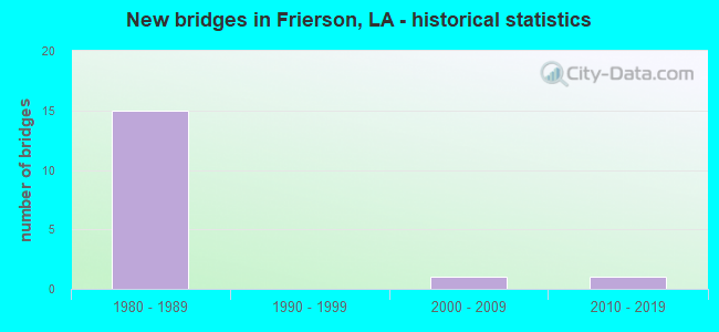
- New bridges - historical statistics
- 151980-1989
- 12000-2009
- 12010-2019


- Bridge Condition - Deck
- 5.9%Very good
- 76.5%Good
- 5.9%Satisfactory
- 11.8%Fair

- Bridge Condition - Superstructure
- 11.8%Very good
- 58.8%Good
- 17.6%Satisfactory
- 11.8%Fair

- Bridge Condition - Substructure
- 5.9%Very good
- 29.4%Good
- 52.9%Satisfactory
- 11.8%Fair

- Bridge Condition - Channel
- 20.0%Very good
- 30.0%Good
- 40.0%Satisfactory
- 10.0%Poor
Find on map >> Show street view
Structure Number: 41600000040386, Location: 2.09 MI N OF I-49 (Lat: 32.240831, Lng: -93.697500), Route carried "on" structure: State highway 175, Year Built: 2014, Status: Open, Structure Length: 3.05m (10.01ft), Average Daily Traffic: 9,300 (year 2016), Truck Traffic: 19%, Average Future Daily Traffic: 5,340 (year 2036), Design Load: HS 20, Features Intersected: FRIERSON BRANCH
Minimum Vertical Clearance: 30+ m (98+ ft), Kilometerpoint: 6.647, Lanes on structure: 2, Owner: State Highway Agency, Approaching Roadway Width: 11.0m (36.1ft), Skew: 30 degrees, Material/Design: Concrete, Design/Construction: Slab, Number Of Spans In Main Unit: 5, Length of Maximum Span: 6.1m (20.0ft), Curb-To-Curb Width: 10.8m (35.4ft), Out-to-Out Width: 11.9m (39.0ft)
Condition: Deck: Very good, Superstructure: Very good, Substructure: Very good, Channel: Good, Operating Rating: 50.5 metric tons, Method Used To Determine Operating Rating: Load and Resistance Factor Rating (LRFR) rating reported by rating factor(RF) method using HL-93 loadings, Inventory Rating: 39.2 metric tons, Method Used To Determine Inventory Rating: Load and Resistance Factor Rating (LRFR) rating reported by rating factor(RF) method using HL-93 loadings, Structural Evaluation: Equal to present desirable criteria, Deck Geometry: Meets minimum limits, Waterway Adequacy: Equal to present desirable criteria, Approach Roadway Alignment: Equal to present minimum criteria, Designated Inspection Frequency: Every 24 months, Underwater Inspection Frequency: Every 60 months, Inspection Date: April 2020, Underwater Inspection Date: June 2020, Deck Structure Type: Concrete Cast-file-Place, Wearing Surface/Protective System: Wearing Surface: Monolithic Concrete
Find on map >> Show street view
Structure Number: 41600350502801, Location: .4 MI EAST OF I-49 (Lat: 32.222839, Lng: -93.704600), Route carried "on" structure: State highway 175, Year Built: 1980, Status: Open, Structure Length: 7.62m (25.00ft), Average Daily Traffic: 9,300 (year 2016), Truck Traffic: 19%, Average Future Daily Traffic: 5,340 (year 2036), Design Load: HS 20, Features Intersected: RAMBIN BAYOU
Minimum Vertical Clearance: 30+ m (98+ ft), Kilometerpoint: 4.371, Lanes on structure: 2, Owner: State Highway Agency, Approaching Roadway Width: 12.8m (42.0ft), Material/Design: Prestressed concrete, Design/Construction: Stringer/Multi-beam, Number Of Spans In Main Unit: 5, Length of Maximum Span: 15.2m (49.9ft), Curb-To-Curb Width: 12.3m (40.4ft), Out-to-Out Width: 13.0m (42.7ft)
Condition: Deck: Good, Superstructure: Very good, Substructure: Satisfactory, Channel: Poor, Operating Rating: 73.5 metric tons, Method Used To Determine Operating Rating: Load Factor (LF), Inventory Rating: 33.6 metric tons, Method Used To Determine Inventory Rating: Load Factor (LF), Structural Evaluation: Equal to present minimum criteria, Deck Geometry: Somewhat better than minimum adequacy, Waterway Adequacy: Equal to present desirable criteria, Approach Roadway Alignment: Equal to present desirable criteria, Designated Inspection Frequency: Every 24 months, Underwater Inspection Frequency: Every 60 months, Inspection Date: June 2021, Underwater Inspection Date: June 2020, Deck Structure Type: Concrete Cast-file-Place
Find on map >> Show street view
Structure Number: 41600980401451, Location: 2.1 MI S OF LA 175 (Lat: 32.193169, Lng: -93.683950), Route carried "on" structure: County highway , Year Built: 1986, Status: Open, Structure Length: 9.75m (31.99ft), Average Daily Traffic: 14,600 (year 2015), Truck Traffic: 22%, Average Future Daily Traffic: 8,760 (year 2036), Design Load: HS 20, Features Intersected: I-49, Facility Carried by Structure: MT. ZION RD
Minimum Vertical Clearance: 30+ m (98+ ft), Kilometerpoint: 39.630, Lanes on structure: 2, Lanes under structure: 4, Owner: State Highway Agency, Approaching Roadway Width: 11.9m (39.0ft), Skew: 1 degrees, Material/Design: Steel continuous, Design/Construction: Girder and Floorbeam System, Number Of Spans In Main Unit: 2, Length of Maximum Span: 48.8m (160.1ft), Curb-To-Curb Width: 9.1m (29.9ft), Out-to-Out Width: 10.0m (32.8ft)
Condition: Deck: Good, Superstructure: Good, Substructure: Good, Operating Rating: 69.8 metric tons, Method Used To Determine Operating Rating: Load Factor (LF), Inventory Rating: 41.7 metric tons, Method Used To Determine Inventory Rating: Load Factor (LF), Structural Evaluation: Better than present minimum criteria, Deck Geometry: Meets minimum limits, Underclear: Better than present minimum criteria, Approach Roadway Alignment: Equal to present desirable criteria, Designated Inspection Frequency: Every 24 months, Inspection Date: June 2021, Deck Structure Type: Concrete Cast-file-Place
Find on map >> Show street view
Structure Number: 41604550725271, Location: 0.56 MI N OF LA 5 OVP (Lat: 32.199819, Lng: -93.689400), Route carried "on" structure: Interstate 49, Year Built: 1987, Status: Open, Structure Length: 31.46m (103.22ft), Average Daily Traffic: 9,950 (year 2016), Truck Traffic: 36%, Average Future Daily Traffic: 6,948 (year 2036), Design Load: HS 20, Features Intersected: I-49, KCS RR
Minimum Vertical Clearance: 30+ m (98+ ft), Kilometerpoint: 40.551, Lanes on structure: 2, Base Highway Network: Yes (Inventory Route: 455-07-1, Subroute: 10), Owner: State Highway Agency, Approaching Roadway Width: 11.6m (38.1ft), Skew: 17 degrees, Material/Design: Prestressed concrete, Design/Construction: Stringer/Multi-beam, Number Of Spans In Main Unit: 15, Length of Maximum Span: 25.3m (83.0ft), Curb-To-Curb Width: 12.2m (40.0ft), Out-to-Out Width: 13.0m (42.7ft)
Condition: Deck: Good, Superstructure: Good, Substructure: Good, Operating Rating: 76.2 metric tons, Method Used To Determine Operating Rating: Load Factor (LF), Inventory Rating: 36.3 metric tons, Method Used To Determine Inventory Rating: Load Factor (LF), Structural Evaluation: Better than present minimum criteria, Deck Geometry: Better than present minimum criteria, Underclear: Superior to present desirable criteria, Approach Roadway Alignment: Equal to present desirable criteria, Designated Inspection Frequency: Every 24 months, Inspection Date: June 2021, Deck Structure Type: Concrete Cast-file-Place
Find on map >> Show street view
Structure Number: 41604550725272, Location: 0.56 MI NO OF LA 5 OVP (Lat: 32.201711, Lng: -93.691497), Route carried "on" structure: Interstate 49, Year Built: 1987, Status: Open, Structure Length: 29.05m (95.31ft), Average Daily Traffic: 9,950 (year 2016), Truck Traffic: 36%, Average Future Daily Traffic: 6,948 (year 2036), Design Load: HS 20, Features Intersected: I-49, KCS RR
Minimum Vertical Clearance: 30+ m (98+ ft), Kilometerpoint: 17.188, Lanes on structure: 2, Base Highway Network: Yes (Inventory Route: 455-07-2, Subroute: 10), Owner: State Highway Agency, Approaching Roadway Width: 11.6m (38.1ft), Skew: 16 degrees, Material/Design: Prestressed concrete, Design/Construction: Stringer/Multi-beam, Number Of Spans In Main Unit: 1, Number Of Approach Spans: 12, Length of Maximum Span: 25.3m (83.0ft), Curb-To-Curb Width: 12.2m (40.0ft), Out-to-Out Width: 13.0m (42.7ft)
Condition: Deck: Good, Superstructure: Good, Substructure: Good, Operating Rating: 76.2 metric tons, Method Used To Determine Operating Rating: Load Factor (LF), Inventory Rating: 36.3 metric tons, Method Used To Determine Inventory Rating: Load Factor (LF), Structural Evaluation: Better than present minimum criteria, Deck Geometry: Better than present minimum criteria, Underclear: Superior to present desirable criteria, Approach Roadway Alignment: Equal to present desirable criteria, Designated Inspection Frequency: Every 24 months, Inspection Date: June 2021, Deck Structure Type: Concrete Cast-file-Place
Find on map >> Show street view
Structure Number: 41604550726792, Location: 2.41 MI. NORTH OF LA 5 (Lat: 32.217661, Lng: -93.706500), Route carried "on" structure: Interstate 49, Year Built: 1986, Status: Open, Structure Length: 10.55m (34.61ft), Average Daily Traffic: 9,950 (year 2016), Truck Traffic: 36%, Average Future Daily Traffic: 6,948 (year 2036), Design Load: HS 20, Features Intersected: I-49 OVER LA 175
Minimum Vertical Clearance: 30+ m (98+ ft), Kilometerpoint: 14.922, Lanes on structure: 2, Lanes under structure: 4, Base Highway Network: Yes (Inventory Route: 455-07-2, Subroute: 10), Owner: State Highway Agency, Approaching Roadway Width: 11.6m (38.1ft), Skew: 13 degrees, Material/Design: Prestressed concrete, Design/Construction: Stringer/Multi-beam, Number Of Spans In Main Unit: 2, Number Of Approach Spans: 2, Length of Maximum Span: 28.3m (92.8ft), Curb-To-Curb Width: 12.1m (39.7ft), Out-to-Out Width: 13.0m (42.7ft)
Condition: Deck: Good, Superstructure: Good, Substructure: Satisfactory, Operating Rating: 62.6 metric tons, Method Used To Determine Operating Rating: Load Factor (LF), Inventory Rating: 37.2 metric tons, Method Used To Determine Inventory Rating: Load Factor (LF), Structural Evaluation: Equal to present minimum criteria, Deck Geometry: Equal to present minimum criteria, Underclear: Equal to present minimum criteria, Approach Roadway Alignment: Equal to present desirable criteria, Designated Inspection Frequency: Every 24 months, Inspection Date: June 2020, Deck Structure Type: Concrete Cast-file-Place
Find on map >> Show street view
Structure Number: 41604550726801, Location: 2.42 MI. N. OF LA 5 (Lat: 32.217181, Lng: -93.705700), Route carried "on" structure: Interstate 49, Year Built: 1986, Status: Open, Structure Length: 10.55m (34.61ft), Average Daily Traffic: 9,950 (year 2016), Truck Traffic: 36%, Average Future Daily Traffic: 6,948 (year 2036), Design Load: HS 20, Features Intersected: I-49 OVER LA 175
Minimum Vertical Clearance: 30+ m (98+ ft), Kilometerpoint: 43.015, Lanes on structure: 2, Lanes under structure: 4, Base Highway Network: Yes (Inventory Route: 455-07-1, Subroute: 10), Owner: State Highway Agency, Approaching Roadway Width: 11.6m (38.1ft), Skew: 13 degrees, Material/Design: Prestressed concrete, Design/Construction: Stringer/Multi-beam, Number Of Spans In Main Unit: 2, Number Of Approach Spans: 2, Length of Maximum Span: 28.3m (92.8ft), Curb-To-Curb Width: 12.1m (39.7ft), Out-to-Out Width: 13.0m (42.7ft)
Condition: Deck: Good, Superstructure: Good, Substructure: Good, Operating Rating: 62.6 metric tons, Method Used To Determine Operating Rating: Load Factor (LF), Inventory Rating: 37.2 metric tons, Method Used To Determine Inventory Rating: Load Factor (LF), Structural Evaluation: Better than present minimum criteria, Deck Geometry: Equal to present minimum criteria, Underclear: Equal to present minimum criteria, Approach Roadway Alignment: Equal to present desirable criteria, Designated Inspection Frequency: Every 24 months, Inspection Date: June 2020, Deck Structure Type: Concrete Cast-file-Place
Find on map >> Show street view
Structure Number: 41604550727101, Location: 0.3 MI. N. OF LA 175 INTG (Lat: 32.220481, Lng: -93.709000), Route carried "on" structure: Interstate 49, Year Built: 1986, Status: Open, Structure Length: 7.92m (25.98ft), Average Daily Traffic: 9,950 (year 2016), Truck Traffic: 36%, Average Future Daily Traffic: 6,948 (year 2036), Design Load: HS 20, Features Intersected: RAMBIN BAYOU
Minimum Vertical Clearance: 30+ m (98+ ft), Kilometerpoint: 43.491, Lanes on structure: 3, Base Highway Network: Yes (Inventory Route: 455-07-1, Subroute: 10), Owner: State Highway Agency, Approaching Roadway Width: 11.6m (38.1ft), Skew: 10 degrees, Material/Design: Concrete, Design/Construction: Slab, Number Of Spans In Main Unit: 13, Length of Maximum Span: 6.1m (20.0ft), Curb-To-Curb Width: 15.7m (51.5ft), Out-to-Out Width: 16.7m (54.8ft)
Condition: Deck: Fair, Superstructure: Fair, Substructure: Fair, Channel: Good, Operating Rating: 68.0 metric tons, Method Used To Determine Operating Rating: Load Factor (LF), Inventory Rating: 40.8 metric tons, Method Used To Determine Inventory Rating: Load Factor (LF), Structural Evaluation: Somewhat better than minimum adequacy, Deck Geometry: Somewhat better than minimum adequacy, Waterway Adequacy: Superior to present desirable criteria, Approach Roadway Alignment: Equal to present desirable criteria, Designated Inspection Frequency: Every 24 months, Inspection Date: June 2020, Deck Structure Type: Concrete Cast-file-Place
Find on map >> Show street view
Structure Number: 41604550727102, Location: 0.3 MI. N. OF LA 175 INTG (Lat: 32.220839, Lng: -93.709800), Route carried "on" structure: Interstate 49, Year Built: 1986, Status: Open, Structure Length: 7.92m (25.98ft), Average Daily Traffic: 9,950 (year 2016), Truck Traffic: 36%, Average Future Daily Traffic: 6,948 (year 2036), Design Load: HS 20, Features Intersected: RAMBIN BAYOU
Minimum Vertical Clearance: 30+ m (98+ ft), Kilometerpoint: 14.458, Lanes on structure: 3, Base Highway Network: Yes (Inventory Route: 455-07-2, Subroute: 10), Owner: State Highway Agency, Approaching Roadway Width: 11.6m (38.1ft), Skew: 10 degrees, Material/Design: Concrete, Design/Construction: Slab, Number Of Spans In Main Unit: 13, Length of Maximum Span: 6.1m (20.0ft), Curb-To-Curb Width: 15.7m (51.5ft), Out-to-Out Width: 19.3m (63.3ft)
Condition: Deck: Satisfactory, Superstructure: Satisfactory, Substructure: Satisfactory, Channel: Good, Operating Rating: 68.0 metric tons, Method Used To Determine Operating Rating: Load Factor (LF), Inventory Rating: 40.8 metric tons, Method Used To Determine Inventory Rating: Load Factor (LF), Structural Evaluation: Equal to present minimum criteria, Deck Geometry: Somewhat better than minimum adequacy, Waterway Adequacy: Equal to present desirable criteria, Approach Roadway Alignment: Equal to present desirable criteria, Designated Inspection Frequency: Every 24 months, Inspection Date: June 2020, Deck Structure Type: Concrete Cast-file-Place
Find on map >> Show street view
Structure Number: 41604550727114, Location: 0.3 MILES NORTH OF LA 175 (Lat: 32.220000, Lng: -93.710000), Route carried "on" structure: ServiceInterstate 49, Year Built: 2006, Status: Open, Structure Length: 3.51m (11.52ft), Average Daily Traffic: 1,490 (year 2016), Truck Traffic: 19%, Average Future Daily Traffic: 1,158 (year 2036), Design Load: HS 20, Features Intersected: LT FRONTAGE RD RAMBIN B.
Minimum Vertical Clearance: 30+ m (98+ ft), Kilometerpoint: 0.000, Lanes on structure: 2, Owner: State Highway Agency, Approaching Roadway Width: 5.8m (19.0ft), Skew: 30 degrees, Material/Design: Concrete, Design/Construction: Slab, Number Of Spans In Main Unit: 6, Length of Maximum Span: 5.8m (19.0ft), Curb-To-Curb Width: 4.9m (16.1ft), Out-to-Out Width: 5.8m (19.0ft)
Condition: Deck: Fair, Superstructure: Fair, Substructure: Fair, Channel: Satisfactory, Operating Rating: 38.9 metric tons, Method Used To Determine Operating Rating: Load and Resistance Factor Rating (LRFR) rating reported by rating factor(RF) method using HL-93 loadings, Inventory Rating: 29.8 metric tons, Method Used To Determine Inventory Rating: Load and Resistance Factor Rating (LRFR) rating reported by rating factor(RF) method using HL-93 loadings, Structural Evaluation: Somewhat better than minimum adequacy, Deck Geometry: High priority of replacement, Waterway Adequacy: Meets minimum limits, Approach Roadway Alignment: Equal to present desirable criteria, Length Of Structure Improvement: 4.39m (14.40ft), Designated Inspection Frequency: Every 24 months, Inspection Date: June 2020, Bridge Improvement Cost: $374,000, Total Project Cost: $561,000 ( Estimate for 2016), Deck Structure Type: Concrete Precast Panels, Wearing Surface/Protective System: Deck Protection: Epoxy Coated Reinforcing
Find on map >> Show street view
Structure Number: 41604550727731, Location: 0.9 MI. N OF LA 175 INTG. (Lat: 32.226539, Lng: -93.717100), Route carried "on" structure: Interstate 49, Year Built: 1986, Status: Open, Structure Length: 5.49m (18.01ft), Average Daily Traffic: 9,950 (year 2016), Truck Traffic: 36%, Average Future Daily Traffic: 6,948 (year 2036), Design Load: HS 20, Features Intersected: BRUSHY BAYOU
Minimum Vertical Clearance: 30+ m (98+ ft), Kilometerpoint: 44.511, Lanes on structure: 2, Base Highway Network: Yes (Inventory Route: 455-07-1, Subroute: 10), Owner: State Highway Agency, Approaching Roadway Width: 11.6m (38.1ft), Skew: 13 degrees, Material/Design: Concrete, Design/Construction: Slab, Number Of Spans In Main Unit: 9, Length of Maximum Span: 6.1m (20.0ft), Curb-To-Curb Width: 12.1m (39.7ft), Out-to-Out Width: 13.0m (42.7ft)
Condition: Deck: Good, Superstructure: Good, Substructure: Satisfactory, Channel: Satisfactory, Operating Rating: 68.0 metric tons, Method Used To Determine Operating Rating: Load Factor (LF), Inventory Rating: 40.8 metric tons, Method Used To Determine Inventory Rating: Load Factor (LF), Structural Evaluation: Equal to present minimum criteria, Deck Geometry: Equal to present minimum criteria, Waterway Adequacy: Equal to present desirable criteria, Approach Roadway Alignment: Equal to present desirable criteria, Designated Inspection Frequency: Every 24 months, Inspection Date: June 2020, Deck Structure Type: Concrete Cast-file-Place
Find on map >> Show street view
Structure Number: 41604550727742, Location: 0.9 MI. N. OF LA 175 INTG (Lat: 32.226800, Lng: -93.717900), Route carried "on" structure: Interstate 49, Year Built: 1986, Status: Open, Structure Length: 5.49m (18.01ft), Average Daily Traffic: 9,950 (year 2016), Truck Traffic: 36%, Average Future Daily Traffic: 6,948 (year 2036), Design Load: HS 20, Features Intersected: BRUSHY BAYOU
Minimum Vertical Clearance: 30+ m (98+ ft), Kilometerpoint: 13.443, Lanes on structure: 2, Base Highway Network: Yes (Inventory Route: 455-07-2, Subroute: 10), Owner: State Highway Agency, Approaching Roadway Width: 11.6m (38.1ft), Skew: 13 degrees, Material/Design: Concrete, Design/Construction: Slab, Number Of Spans In Main Unit: 9, Length of Maximum Span: 6.1m (20.0ft), Curb-To-Curb Width: 12.1m (39.7ft), Out-to-Out Width: 13.0m (42.7ft)
Condition: Deck: Good, Superstructure: Good, Substructure: Satisfactory, Channel: Satisfactory, Operating Rating: 68.0 metric tons, Method Used To Determine Operating Rating: Load Factor (LF), Inventory Rating: 40.8 metric tons, Method Used To Determine Inventory Rating: Load Factor (LF), Structural Evaluation: Equal to present minimum criteria, Deck Geometry: Equal to present minimum criteria, Waterway Adequacy: Equal to present desirable criteria, Approach Roadway Alignment: Equal to present desirable criteria, Designated Inspection Frequency: Every 24 months, Underwater Inspection Frequency: Every 60 months, Inspection Date: June 2020, Underwater Inspection Date: June 2020, Deck Structure Type: Concrete Cast-file-Place
Find on map >> Show street view
Structure Number: 41604550728111, Location: 1.3 MI. N. OF LA 175 INTG (Lat: 32.230131, Lng: -93.722000), Route carried "on" structure: Interstate 49, Year Built: 1986, Status: Open, Structure Length: 4.88m (16.01ft), Average Daily Traffic: 9,950 (year 2016), Truck Traffic: 36%, Average Future Daily Traffic: 6,948 (year 2036), Design Load: HS 20, Features Intersected: SYLVEST CREEK
Minimum Vertical Clearance: 30+ m (98+ ft), Kilometerpoint: 45.123, Lanes on structure: 2, Base Highway Network: Yes (Inventory Route: 455-07-1, Subroute: 10), Owner: State Highway Agency, Approaching Roadway Width: 11.6m (38.1ft), Skew: 13 degrees, Material/Design: Concrete, Design/Construction: Slab, Number Of Spans In Main Unit: 8, Length of Maximum Span: 6.1m (20.0ft), Curb-To-Curb Width: 12.2m (40.0ft), Out-to-Out Width: 13.0m (42.7ft)
Condition: Deck: Good, Superstructure: Good, Substructure: Satisfactory, Channel: Very good, Operating Rating: 67.1 metric tons, Method Used To Determine Operating Rating: Load Factor (LF), Inventory Rating: 39.9 metric tons, Method Used To Determine Inventory Rating: Load Factor (LF), Structural Evaluation: Equal to present minimum criteria, Deck Geometry: Better than present minimum criteria, Waterway Adequacy: Equal to present desirable criteria, Approach Roadway Alignment: Equal to present desirable criteria, Designated Inspection Frequency: Every 24 months, Inspection Date: June 2020, Deck Structure Type: Concrete Cast-file-Place
Find on map >> Show street view
Structure Number: 41604550728122, Location: 1.3 MI N OF LA 175 INTG (Lat: 32.230400, Lng: -93.722900), Route carried "on" structure: Interstate 49, Year Built: 1986, Status: Open, Structure Length: 4.88m (16.01ft), Average Daily Traffic: 9,950 (year 2016), Truck Traffic: 36%, Average Future Daily Traffic: 6,948 (year 2036), Design Load: HS 20, Features Intersected: SYLVEST CREEK
Minimum Vertical Clearance: 30+ m (98+ ft), Kilometerpoint: 12.830, Lanes on structure: 2, Base Highway Network: Yes (Inventory Route: 455-07-2, Subroute: 10), Owner: State Highway Agency, Approaching Roadway Width: 11.6m (38.1ft), Skew: 13 degrees, Material/Design: Concrete, Design/Construction: Slab, Number Of Spans In Main Unit: 8, Length of Maximum Span: 6.1m (20.0ft), Curb-To-Curb Width: 12.1m (39.7ft), Out-to-Out Width: 13.0m (42.7ft)
Condition: Deck: Good, Superstructure: Good, Substructure: Satisfactory, Channel: Very good, Operating Rating: 67.1 metric tons, Method Used To Determine Operating Rating: Load Factor (LF), Inventory Rating: 39.9 metric tons, Method Used To Determine Inventory Rating: Load Factor (LF), Structural Evaluation: Equal to present minimum criteria, Deck Geometry: Equal to present minimum criteria, Waterway Adequacy: Equal to present desirable criteria, Approach Roadway Alignment: Equal to present desirable criteria, Designated Inspection Frequency: Every 24 months, Inspection Date: June 2020, Deck Structure Type: Concrete Cast-file-Place
Find on map >> Show street view
Structure Number: 41604550729041, Location: 2.2 MI N. OF LA 175 INTG (Lat: 32.241131, Lng: -93.731200), Route carried "on" structure: Interstate 49, Year Built: 1986, Status: Open, Structure Length: 5.03m (16.50ft), Average Daily Traffic: 9,950 (year 2016), Truck Traffic: 36%, Average Future Daily Traffic: 6,948 (year 2036), Design Load: HS 20, Features Intersected: I-49 OVER RED BLUFF RD
Minimum Vertical Clearance: 30+ m (98+ ft), Kilometerpoint: 46.623, Lanes on structure: 2, Lanes under structure: 2, Base Highway Network: Yes (Inventory Route: 455-07-1, Subroute: 10), Owner: State Highway Agency, Approaching Roadway Width: 11.6m (38.1ft), Skew: 12 degrees, Material/Design: Prestressed concrete, Design/Construction: Stringer/Multi-beam, Number Of Spans In Main Unit: 1, Number Of Approach Spans: 2, Length of Maximum Span: 21.3m (69.9ft), Curb-To-Curb Width: 12.1m (39.7ft), Out-to-Out Width: 13.0m (42.7ft)
Condition: Deck: Good, Superstructure: Satisfactory, Substructure: Satisfactory, Operating Rating: 58.0 metric tons, Method Used To Determine Operating Rating: Load Factor (LF), Inventory Rating: 34.5 metric tons, Method Used To Determine Inventory Rating: Load Factor (LF), Structural Evaluation: Equal to present minimum criteria, Deck Geometry: Equal to present minimum criteria, Underclear: Somewhat better than minimum adequacy, Approach Roadway Alignment: Equal to present desirable criteria, Designated Inspection Frequency: Every 24 months, Inspection Date: June 2020, Deck Structure Type: Concrete Cast-file-Place
Find on map >> Show street view
Structure Number: 41604550729052, Location: 2.2 MI N OF LA 175 INTG (Lat: 32.241469, Lng: -93.732100), Route carried "on" structure: Interstate 49, Year Built: 1986, Status: Open, Structure Length: 5.03m (16.50ft), Average Daily Traffic: 9,950 (year 2016), Truck Traffic: 36%, Average Future Daily Traffic: 6,948 (year 2036), Design Load: HS 20, Features Intersected: I-49 OVER RED BLUFF RD
Minimum Vertical Clearance: 30+ m (98+ ft), Kilometerpoint: 11.320, Lanes on structure: 2, Lanes under structure: 2, Base Highway Network: Yes (Inventory Route: 455-07-2, Subroute: 10), Owner: State Highway Agency, Approaching Roadway Width: 11.6m (38.1ft), Skew: 12 degrees, Material/Design: Prestressed concrete, Design/Construction: Stringer/Multi-beam, Number Of Spans In Main Unit: 1, Number Of Approach Spans: 2, Length of Maximum Span: 21.3m (69.9ft), Curb-To-Curb Width: 12.1m (39.7ft), Out-to-Out Width: 13.0m (42.7ft)
Condition: Deck: Good, Superstructure: Satisfactory, Substructure: Satisfactory, Operating Rating: 58.0 metric tons, Method Used To Determine Operating Rating: Load Factor (LF), Inventory Rating: 34.5 metric tons, Method Used To Determine Inventory Rating: Load Factor (LF), Structural Evaluation: Equal to present minimum criteria, Deck Geometry: Equal to present minimum criteria, Underclear: Better than present minimum criteria, Approach Roadway Alignment: Equal to present desirable criteria, Designated Inspection Frequency: Every 24 months, Inspection Date: June 2020, Deck Structure Type: Concrete Cast-file-Place
Find on map >> Show street view
Structure Number: 41632130933981, Location: 3.3 MI SE OF LA 17S (Lat: 32.216761, Lng: -93.663650), Route carried "on" structure: County highway , Year Built: 1985, Status: Open, Structure Length: 1.16m (3.81ft), Average Daily Traffic: 200 (year 2021), Average Future Daily Traffic: 220 (year 2041), Design Load: HS 20, Features Intersected: CALDWELL B., Facility Carried by Structure: Friendship Rd
Minimum Vertical Clearance: 30+ m (98+ ft), Kilometerpoint: 0.000, Lanes on structure: 2, Owner: County Highway Agency, Approaching Roadway Width: 5.8m (19.0ft), Material/Design: Concrete, Design/Construction: Slab, Number Of Spans In Main Unit: 2, Length of Maximum Span: 5.8m (19.0ft), Curb-To-Curb Width: 7.3m (24.0ft), Out-to-Out Width: 8.2m (26.9ft)
Condition: Deck: Good, Superstructure: Good, Substructure: Good, Channel: Satisfactory, Operating Rating: 36.6 metric tons, Method Used To Determine Operating Rating: Load and Resistance Factor Rating (LRFR) rating reported by rating factor(RF) method using HL-93 loadings, Inventory Rating: 28.2 metric tons, Method Used To Determine Inventory Rating: Load and Resistance Factor Rating (LRFR) rating reported by rating factor(RF) method using HL-93 loadings, Structural Evaluation: Better than present minimum criteria, Deck Geometry: Somewhat better than minimum adequacy, Waterway Adequacy: Equal to present minimum criteria, Approach Roadway Alignment: Equal to present minimum criteria, Designated Inspection Frequency: Every 24 months, Inspection Date: October 2020, Deck Structure Type: Concrete Cast-file-Place
Find on map >> Show street view
Structure Number: 41600980401451, Location: 2.2 miles south of LA 175 (Lat: 32.193339, Lng: -93.683311), Route carried "under" structure: Interstate 49, Structure Length: 0. m, Average Daily Traffic: 14,600 (year 2015), Features Intersected: I49 north under Mt. Zion
Minimum Vertical Clearance: 5.18m (16.99ft), Kilometerpoint: 39.632, Lanes on structure: 2, Length of Maximum Span: 0.0m
Find on map >> Show street view
Structure Number: 41600980401451, Location: 2.2 miles south of LA 175 (Lat: 32.193331, Lng: -93.683650), Route carried "under" structure: Interstate 49, Structure Length: 0. m, Average Daily Traffic: 14,600 (year 2015), Features Intersected: I49 south under Mt. Zion
Minimum Vertical Clearance: 5.24m (17.19ft), Kilometerpoint: 18.377, Lanes on structure: 2, Length of Maximum Span: 0.0m
Find on map >> Show street view
Structure Number: 41604550726792, Location: 5.7 MILE SOUTH OF LA 3276 (Lat: 32.217069, Lng: -93.706119), Route carried "under" structure: Interstate 49, Structure Length: 0. m, Average Daily Traffic: 11,580 (year 2015), Features Intersected: I49 SOUTH OVER 175 NORTH
Minimum Vertical Clearance: 5.61m (18.41ft), Kilometerpoint: 3.713, Lanes on structure: 2, Length of Maximum Span: 0.0m
Find on map >> Show street view
Structure Number: 41604550726792, Location: 5.7 MILE SOUTH OF LA 3276 (Lat: 32.217400, Lng: -93.706189), Route carried "under" structure: Interstate 49, Structure Length: 0. m, Average Daily Traffic: 11,580 (year 2015), Features Intersected: I49 SOUTH OVER 175 SOUTH
Minimum Vertical Clearance: 5.24m (17.19ft), Kilometerpoint: 12.023, Lanes on structure: 2, Length of Maximum Span: 0.0m
Find on map >> Show street view
Structure Number: 41604550726801, Location: 5.7 MILES SOUTH OF LA 327 (Lat: 32.217381, Lng: -93.706011), Route carried "under" structure: Interstate 49, Structure Length: 0. m, Average Daily Traffic: 11,580 (year 2015), Features Intersected: I49 NORTH OVER 175 NORTH
Minimum Vertical Clearance: 5.58m (18.31ft), Kilometerpoint: 3.750, Lanes on structure: 2, Length of Maximum Span: 0.0m
Find on map >> Show street view
Structure Number: 41604550726801, Location: 5.7 MILES SOUTH OF LA 327 (Lat: 32.217711, Lng: -93.706089), Route carried "under" structure: Interstate 49, Structure Length: 0. m, Average Daily Traffic: 11,580 (year 2015), Features Intersected: I49 NORTH OVER 175 SOUTH
Minimum Vertical Clearance: 5.73m (18.80ft), Kilometerpoint: 11.986, Lanes on structure: 2, Length of Maximum Span: 0.0m