Bridge Statistics for Frontenac, Missouri (MO)
Condition, Traffic, Stress, Structural Evaluation, Project Costs
- National Bridge Inventory (NBI) Statistics
- 12Number of bridges
- 75ft / 23.0mTotal length
- $258,000Total costs
- 407,672Total average daily traffic
- 44,629Total average daily truck traffic
- National Bridge Inventory (NBI) Registered Bridges for Frontenac
- No street view available for this location
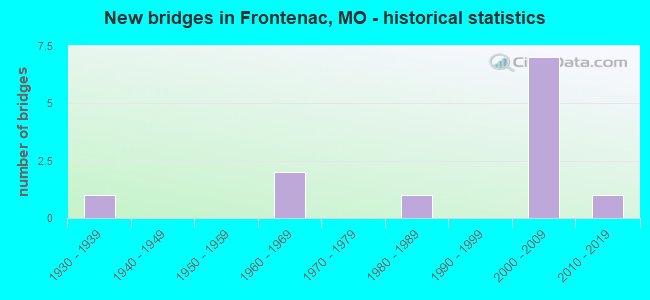
- New bridges - historical statistics
- 11930-1939
- 21960-1969
- 11980-1989
- 72000-2009
- 12010-2019

- Reconstructed bridges - Historical Statistics
- 11960-1969
- 11970-1979


- Bridge Condition - Deck
- 16.7%Very good
- 33.3%Good
- 16.7%Satisfactory
- 33.3%Fair

- Bridge Condition - Superstructure
- 16.7%Excellent
- 50.0%Good
- 16.7%Fair
- 16.7%Poor

- Bridge Condition - Substructure
- 50.0%Good
- 33.3%Satisfactory
- 16.7%Poor

- Bridge Condition - Channel
- 75.0%Satisfactory
- 25.0%Fair
Find on map >> Show street view
Structure Number: 171, Location: S 10 T 48 N R 21 W (Lat: 38.962019, Lng: -93.207231), Route carried "on" structure: Interstate 70, Year Built: 1960, Year Reconstructed: 1983, Status: Open, Structure Length: 7.62m (25.00ft), Average Daily Traffic: 14,660 (year 2021), Truck Traffic: 24%, Average Future Daily Traffic: 25,655 (year 2041), Design Load: HS 20, Features Intersected: US 65
Minimum Vertical Clearance: 30+ m (98+ ft), Kilometerpoint: 276.481, Lanes on structure: 3, Lanes under structure: 6, Base Highway Network: Yes, Owner: State Highway Agency, Approaching Roadway Width: 11.6m (38.1ft), Skew: 1 degrees, Material/Design: Steel continuous, Design/Construction: Stringer/Multi-beam, Number Of Spans In Main Unit: 4, Length of Maximum Span: 20.7m (67.9ft), Curb-To-Curb Width: 13.7m (44.9ft), Out-to-Out Width: 14.5m (47.6ft)
Condition: Deck: Very good, Superstructure: Good, Substructure: Good, Operating Rating: 72.0 metric tons, Method Used To Determine Operating Rating: Load Factor (LF), Inventory Rating: 43.2 metric tons, Method Used To Determine Inventory Rating: Load Factor (LF), Structural Evaluation: Better than present minimum criteria, Deck Geometry: Meets minimum limits, Underclear: Meets minimum limits, Approach Roadway Alignment: Equal to present desirable criteria, Designated Inspection Frequency: Every 24 months, Inspection Date: December 2021, Deck Structure Type: Concrete Cast-file-Place, Wearing Surface/Protective System: Wearing Surface: Low Slump Concrete, Membrane: Built-up
Find on map >> Show street view
Structure Number: 17518, Location: S 13 T 45 N R 5 E (Lat: 38.644972, Lng: -90.415325), Route carried "on" structure: City street , Year Built: 1981, Status: Posted for load, Structure Length: 1.34m (4.40ft), Average Daily Traffic: 8,060 (year 2020), Truck Traffic: 1%, Average Future Daily Traffic: 10,881 (year 2040), Design Load: HS 20, Features Intersected: DEER CR, Facility Carried by Structure: SPOEDE RD
Minimum Vertical Clearance: 30+ m (98+ ft), Kilometerpoint: 0.483, Lanes on structure: 2, Owner: City or Municipal Highway Agency, Approaching Roadway Width: 8.5m (27.9ft), Material/Design: Prestressed concrete, Design/Construction: Stringer/Multi-beam, Number Of Spans In Main Unit: 1, Length of Maximum Span: 13.1m (43.0ft), Curb-To-Curb Width: 8.7m (28.5ft), Out-to-Out Width: 10.9m (35.8ft)
Condition: Deck: Fair, Superstructure: Poor, Substructure: Poor, Channel: Satisfactory, Operating Rating: 62.1 metric tons, Method Used To Determine Operating Rating: Field evaluation and documented engineering judgment, Inventory Rating: 40.5 metric tons, Method Used To Determine Inventory Rating: Field evaluation and documented engineering judgment, Structural Evaluation: Meets minimum limits, Deck Geometry: High priority of replacement, Waterway Adequacy: Equal to present desirable criteria, Approach Roadway Alignment: Equal to present minimum criteria, Length Of Structure Improvement: 0.20m (0.66ft), Designated Inspection Frequency: Every 24 months, Inspection Date: January 2022, Bridge Improvement Cost: $172,000, Roadway Improvement Cost: $17,000, Total Project Cost: $258,000 ( Estimate for 2022), Deck Structure Type: Concrete Cast-file-Place, Wearing Surface/Protective System: Wearing Surface: Monolithic Concrete, Membrane: Epoxy
Find on map >> Show street view
Structure Number: 32227, Location: S 2675 T 45 N R 5 E (Lat: 38.635536, Lng: -90.405689), Route carried "on" structure: Interstate 64, Year Built: 2008, Status: Open, Structure Length: 4.63m (15.19ft), Average Daily Traffic: 144,058 (year 2021), Truck Traffic: 12%, Average Future Daily Traffic: 180,073 (year 2041), Design Load: HS 25 or greater, Features Intersected: US 67, US 61, RP IS64W T
Minimum Vertical Clearance: 30+ m (98+ ft), Kilometerpoint: 45.475, Lanes on structure: 8, Lanes under structure: 10, Base Highway Network: Yes, Owner: State Highway Agency, Approaching Roadway Width: 19.8m (65.0ft), Material/Design: Steel, Design/Construction: Stringer/Multi-beam, Number Of Spans In Main Unit: 1, Length of Maximum Span: 45.4m (149.0ft), Curb-To-Curb Width: 39.6m (129.9ft), Out-to-Out Width: 41.0m (134.5ft)
Condition: Deck: Satisfactory, Superstructure: Good, Substructure: Good, Operating Rating: 90.9 metric tons, Method Used To Determine Operating Rating: Load Factor (LF), Inventory Rating: 54.9 metric tons, Method Used To Determine Inventory Rating: Load Factor (LF), Structural Evaluation: Better than present minimum criteria, Deck Geometry: Superior to present desirable criteria, Underclear: Better than present minimum criteria, Approach Roadway Alignment: Equal to present desirable criteria, Designated Inspection Frequency: Every 24 months, Inspection Date: October 2020, Deck Structure Type: Concrete Cast-file-Place, Wearing Surface/Protective System: Wearing Surface: Epoxy Overlay, Deck Protection: Epoxy Coated Reinforcing
Find on map >> Show street view
Structure Number: 32245, Location: S 13 T 45 N R 5 E (Lat: 38.635600, Lng: -90.415439), Route carried "on" structure: City street , Year Built: 2008, Status: Open, Structure Length: 5.64m (18.50ft), Average Daily Traffic: 10,719 (year 2021), Truck Traffic: 5%, Average Future Daily Traffic: 16,079 (year 2041), Design Load: HS 20+Mod, Features Intersected: IS 64, RP IS64W TO SPOED, Facility Carried by Structure: SPOEDE RD S
Minimum Vertical Clearance: 30+ m (98+ ft), Kilometerpoint: 2.142, Lanes on structure: 2, Lanes under structure: 10, Owner: State Highway Agency, Approaching Roadway Width: 13.5m (44.3ft), Material/Design: Prestressed concrete continuous, Design/Construction: Stringer/Multi-beam, Number Of Spans In Main Unit: 2, Length of Maximum Span: 30.5m (100.1ft), Curb-To-Curb Width: 11.0m (36.1ft), Out-to-Out Width: 13.5m (44.3ft)
Condition: Deck: Good, Superstructure: Good, Substructure: Satisfactory, Operating Rating: 81.0 metric tons, Method Used To Determine Operating Rating: Load Factor (LF), Inventory Rating: 44.1 metric tons, Method Used To Determine Inventory Rating: Load Factor (LF), Structural Evaluation: Equal to present minimum criteria, Deck Geometry: Meets minimum limits, Underclear: High priority of corrective action, Approach Roadway Alignment: Equal to present desirable criteria, Designated Inspection Frequency: Every 24 months, Inspection Date: October 2020, Deck Structure Type: Concrete Cast-file-Place, Wearing Surface/Protective System: Wearing Surface: Epoxy Overlay, Deck Protection: Epoxy Coated Reinforcing
Find on map >> Show street view
Structure Number: 34071, Location: S 26 T 45 N R 5 E (Lat: 38.614664, Lng: -90.415694), Route carried "on" structure: City street , Year Built: 2012, Status: Posted for load, Structure Length: 1.50m (4.92ft), Average Daily Traffic: 6,000 (year 2020), Truck Traffic: 1%, Average Future Daily Traffic: 8,100 (year 2040), Design Load: HS 20, Features Intersected: TWO MILE CR, Facility Carried by Structure: GEYER RD
Minimum Vertical Clearance: 30+ m (98+ ft), Kilometerpoint: 0.000, Lanes on structure: 2, Owner: City or Municipal Highway Agency, Approaching Roadway Width: 7.3m (24.0ft), Skew: 2 degrees, Material/Design: Concrete, Design/Construction: Slab, Number Of Spans In Main Unit: 1, Length of Maximum Span: 13.8m (45.3ft), Curb or Sidewalk Widths: Left: 3.3m (10.8ft), Right: 0.0m, Curb-To-Curb Width: 12.4m (40.7ft), Out-to-Out Width: 13.4m (44.0ft)
Condition: Deck: Good, Superstructure: Excellent, Substructure: Good, Channel: Satisfactory, Operating Rating: 54.0 metric tons, Method Used To Determine Operating Rating: Load Factor (LF), Inventory Rating: 32.4 metric tons, Method Used To Determine Inventory Rating: Load Factor (LF), Structural Evaluation: Better than present minimum criteria, Deck Geometry: Somewhat better than minimum adequacy, Waterway Adequacy: Superior to present desirable criteria, Approach Roadway Alignment: Equal to present desirable criteria, Designated Inspection Frequency: Every 24 months, Inspection Date: January 2022, Deck Structure Type: Concrete Cast-file-Place, Wearing Surface/Protective System: Wearing Surface: Monolithic Concrete, Deck Protection: Epoxy Coated Reinforcing
Find on map >> Show street view
Structure Number: 519, Location: S 59 T 44 N R 2 E (Lat: 38.597394, Lng: -90.802319), Route carried "on" structure: State highway 94, Year Built: 1961, Status: Open, Structure Length: 0.98m (3.22ft), Average Daily Traffic: 1,714 (year 2021), Truck Traffic: 10%, Average Future Daily Traffic: 3,085 (year 2041), Design Load: H 15, Features Intersected: FISCHER CR
Minimum Vertical Clearance: 30+ m (98+ ft), Kilometerpoint: 141.317, Lanes on structure: 2, Base Highway Network: Yes, Owner: State Highway Agency, Approaching Roadway Width: 7.9m (25.9ft), Material/Design: Concrete continuous, Design/Construction: Culvert, Number Of Spans In Main Unit: 3, Length of Maximum Span: 3.0m (9.8ft), Curb-To-Curb Width: 12.5m (41.0ft), Out-to-Out Width: 13.1m (43.0ft)
Condition: Channel: Satisfactory, Culverts: Satisfactory, Operating Rating: 86.4 metric tons, Method Used To Determine Operating Rating: Load Factor (LF), Inventory Rating: 52.2 metric tons, Method Used To Determine Inventory Rating: Load Factor (LF), Structural Evaluation: Equal to present minimum criteria, Deck Geometry: Better than present minimum criteria, Waterway Adequacy: Equal to present minimum criteria, Approach Roadway Alignment: Equal to present desirable criteria, Designated Inspection Frequency: Every 24 months, Inspection Date: November 2021
Find on map >> Show street view
Structure Number: 519, Location: S 13 T 45 N R 5 E (Lat: 38.642114, Lng: -90.405519), Route carried "on" structure: US 67, Year Built: 1930, Year Reconstructed: 1968, Status: Posted for load, Structure Length: 1.31m (4.30ft), Average Daily Traffic: 29,369 (year 2021), Truck Traffic: 6%, Average Future Daily Traffic: 41,117 (year 2041), Design Load: HS 20, Features Intersected: DEER CR
Minimum Vertical Clearance: 30+ m (98+ ft), Kilometerpoint: 40.491, Lanes on structure: 5, Base Highway Network: Yes, Owner: State Highway Agency, Approaching Roadway Width: 9.6m (31.5ft), Skew: 30 degrees, Material/Design: Concrete, Design/Construction: Tee Beam, Number Of Spans In Main Unit: 1, Length of Maximum Span: 13.0m (42.7ft), Curb or Sidewalk Widths: Left: 1.2m (3.9ft), Right: 1.2m (3.9ft), Curb-To-Curb Width: 19.8m (65.0ft), Out-to-Out Width: 23.4m (76.8ft)
Condition: Deck: Fair, Superstructure: Fair, Substructure: Satisfactory, Channel: Fair, Operating Rating: 36.9 metric tons, Method Used To Determine Operating Rating: Load Factor (LF), Inventory Rating: 22.5 metric tons, Method Used To Determine Inventory Rating: Load Factor (LF), Structural Evaluation: Somewhat better than minimum adequacy, Deck Geometry: Meets minimum limits, Waterway Adequacy: Equal to present desirable criteria, Approach Roadway Alignment: Equal to present desirable criteria, Designated Inspection Frequency: Every 24 months, Inspection Date: October 2020, Deck Structure Type: Concrete Cast-file-Place, Wearing Surface/Protective System: Wearing Surface: Bituminous, Membrane: Built-up
Find on map >> Show street view
Structure Number: 32227, Location: S 2675 T 45 N R 5 E (Lat: 38.635536, Lng: -90.405689), Route carried "under" structure: US 67, Year Built: 2008, Structure Length: 0. m, Average Daily Traffic: 14,995 (year 2021), Truck Traffic: 6%, Features Intersected: US 67, Facility Carried by Structure: IS 64 E
Minimum Vertical Clearance: 5.13m (16.83ft), Kilometerpoint: 276.911, Lanes on structure: 8, Lanes under structure: 2, Material/Design: Steel, Design/Construction: Stringer/Multi-beam, Length of Maximum Span: 45.4m (149.0ft)
Find on map >> Show street view
Structure Number: 32227, Location: S 2675 T 45 N R 5 E (Lat: 38.635536, Lng: -90.405689), Route carried "under" structure: US 67, Year Built: 2008, Structure Length: 0. m, Average Daily Traffic: 14,374 (year 2021), Truck Traffic: 6%, Features Intersected: US 67, Facility Carried by Structure: IS 64 E
Minimum Vertical Clearance: 4.83m (15.85ft), Kilometerpoint: 41.230, Lanes on structure: 8, Lanes under structure: 2, Material/Design: Steel, Design/Construction: Stringer/Multi-beam, Length of Maximum Span: 45.4m (149.0ft)
Find on map >> Show street view
Structure Number: 32227, Location: S 2675 T 45 N R 5 E (Lat: 38.635536, Lng: -90.405689), Route carried "under" structure: US 61, Year Built: 2008, Structure Length: 0. m, Average Daily Traffic: 9,504 (year 2021), Truck Traffic: 10%, Features Intersected: US 61, Facility Carried by Structure: IS 64 E
Minimum Vertical Clearance: 4.93m (16.17ft), Kilometerpoint: 369.326, Lanes on structure: 8, Lanes under structure: 2, Material/Design: Steel, Design/Construction: Stringer/Multi-beam, Length of Maximum Span: 45.4m (149.0ft)
Find on map >> Show street view
Structure Number: 32245, Location: S 13 T 45 N R 5 E (Lat: 38.635600, Lng: -90.415439), Route carried "under" structure: Interstate 64, Year Built: 2008, Structure Length: 0. m, Average Daily Traffic: 69,569 (year 2021), Truck Traffic: 12%, Features Intersected: IS 64, Facility Carried by Structure: SPOEDE RD S
Minimum Vertical Clearance: 4.78m (15.68ft), Kilometerpoint: 44.651, Lanes on structure: 2, Lanes under structure: 4, Material/Design: Prestressed concrete continuous, Design/Construction: Stringer/Multi-beam, Length of Maximum Span: 30.5m (100.1ft)
Find on map >> Show street view
Structure Number: 32245, Location: S 13 T 45 N R 5 E (Lat: 38.635600, Lng: -90.415439), Route carried "under" structure: Interstate 64, Year Built: 2008, Structure Length: 0. m, Average Daily Traffic: 84,650 (year 2021), Truck Traffic: 12%, Features Intersected: IS 64, Facility Carried by Structure: SPOEDE RD S
Minimum Vertical Clearance: 4.78m (15.68ft), Kilometerpoint: 21.049, Lanes on structure: 2, Lanes under structure: 4, Material/Design: Prestressed concrete continuous, Design/Construction: Stringer/Multi-beam, Length of Maximum Span: 30.5m (100.1ft)