Bridge Statistics for Fulton, Arkansas (AR)
Condition, Traffic, Stress, Structural Evaluation, Project Costs
- National Bridge Inventory (NBI) Statistics
- 49Number of bridges
- 892ft / 272mTotal length
- $3,754,000Total costs
- 309,355Total average daily traffic
- 101,075Total average daily truck traffic
- National Bridge Inventory (NBI) Registered Bridges for Fulton
- No street view available for this location
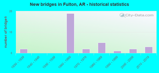
- New bridges - historical statistics
- 21930-1939
- 191960-1969
- 21970-1979
- 51980-1989
- 11990-1999
- 22000-2009
- 32010-2019

- Reconstructed bridges - Historical Statistics
- 61980-1989
- 41990-1999


- Bridge Condition - Deck
- 16.1%Very good
- 51.6%Good
- 32.3%Satisfactory

- Bridge Condition - Superstructure
- 19.4%Very good
- 48.4%Good
- 29.0%Satisfactory
- 3.2%Fair

- Bridge Condition - Substructure
- 16.1%Very good
- 51.6%Good
- 29.0%Satisfactory
- 3.2%Fair

- Bridge Condition - Channel
- 16.0%Very good
- 60.0%Good
- 20.0%Satisfactory
- 4.0%Fair

- Bridge Condition - Culverts
- 33.3%Good
- 66.7%Satisfactory
Find on map >> Show street view
Structure Number: 1598, Location: 2.0 M E OF JCT I-30 (Lat: 33.616847, Lng: -93.759628), Route carried "on" structure: US 67, Year Built: 1930, Status: Open, Structure Length: 2.77m (9.09ft), Average Daily Traffic: 2,900 (year 2018), Truck Traffic: 18%, Average Future Daily Traffic: 2,496 (year 2028), Design Load: H 15, Features Intersected: BRIDGE CREEK RELIEF
Minimum Vertical Clearance: 30+ m (98+ ft), Kilometerpoint: 5.327, Lanes on structure: 2, Owner: State Highway Agency, Approaching Roadway Width: 11.6m (38.1ft), Material/Design: Concrete, Design/Construction: Tee Beam, Number Of Spans In Main Unit: 3, Length of Maximum Span: 9.1m (29.9ft), Curb or Sidewalk Widths: Left: 0.3m (1.0ft), Right: 0.3m (1.0ft), Curb-To-Curb Width: 7.3m (24.0ft), Out-to-Out Width: 8.2m (26.9ft)
Condition: Deck: Good, Superstructure: Good, Substructure: Satisfactory, Channel: Good, Operating Rating: 54.4 metric tons, Method Used To Determine Operating Rating: Load Factor (LF), Inventory Rating: 32.7 metric tons, Method Used To Determine Inventory Rating: Load Factor (LF), Structural Evaluation: Equal to present minimum criteria, Deck Geometry: High priority of replacement, Waterway Adequacy: Equal to present minimum criteria, Approach Roadway Alignment: Better than present minimum criteria, Length Of Structure Improvement: 3.57m (11.71ft), Designated Inspection Frequency: Every 24 months, Critical Feature Inspection Frequency: Every 24 months, Inspection Date: September 2020, Roadway Improvement Cost: $125,000, Total Project Cost: $351,000, Deck Structure Type: Concrete Cast-file-Place, Wearing Surface/Protective System: Wearing Surface: Bituminous
Find on map >> Show street view
Structure Number: 3543, Location: 3.29 MI SE OF LOGAN CO (Lat: 35.258139, Lng: -93.229028), Route carried "on" structure: State highway 22, Year Built: 1963, Status: Open, Structure Length: 4.57m (14.99ft), Average Daily Traffic: 4,261 (year 2018), Truck Traffic: 1%, Average Future Daily Traffic: 3,848 (year 2028), Design Load: HS 20, Features Intersected: Jones Creek
Minimum Vertical Clearance: 30+ m (98+ ft), Kilometerpoint: 5.279, Lanes on structure: 2, Base Highway Network: Yes, Owner: State Highway Agency, Approaching Roadway Width: 9.4m (30.8ft), Material/Design: Concrete, Design/Construction: Slab, Number Of Spans In Main Unit: 5, Length of Maximum Span: 9.1m (29.9ft), Curb-To-Curb Width: 8.5m (27.9ft), Out-to-Out Width: 10.2m (33.5ft)
Condition: Deck: Good, Superstructure: Good, Substructure: Satisfactory, Channel: Good, Operating Rating: 54.4 metric tons, Method Used To Determine Operating Rating: Load Factor (LF), Inventory Rating: 32.7 metric tons, Method Used To Determine Inventory Rating: Load Factor (LF), Structural Evaluation: Equal to present minimum criteria, Deck Geometry: Meets minimum limits, Waterway Adequacy: Equal to present desirable criteria, Approach Roadway Alignment: Equal to present desirable criteria, Designated Inspection Frequency: Every 24 months, Critical Feature Inspection Frequency: Every 24 months, Inspection Date: June 2020, Deck Structure Type: Concrete Cast-file-Place, Wearing Surface/Protective System: Wearing Surface: Bituminous
Find on map >> Show street view
Structure Number: 3634, Location: 7.15 MI NW JCT SH 115 (Lat: 36.393428, Lng: -91.007939), Route carried "on" structure: State highway 251, Year Built: 1964, Status: Open, Structure Length: 4.57m (14.99ft), Average Daily Traffic: 970 (year 2018), Truck Traffic: 7%, Average Future Daily Traffic: 1,391 (year 2028), Design Load: H 15, Features Intersected: TENNESSEE CREEK
Minimum Vertical Clearance: 30+ m (98+ ft), Kilometerpoint: 11.507, Lanes on structure: 2, Owner: State Highway Agency, Approaching Roadway Width: 9.1m (29.9ft), Skew: 5 degrees, Material/Design: Concrete, Design/Construction: Slab, Number Of Spans In Main Unit: 6, Length of Maximum Span: 7.6m (24.9ft), Curb or Sidewalk Widths: Left: 0.2m (0.7ft), Right: 0.2m (0.7ft), Curb-To-Curb Width: 7.3m (24.0ft), Out-to-Out Width: 8.7m (28.5ft)
Condition: Deck: Satisfactory, Superstructure: Satisfactory, Substructure: Satisfactory, Channel: Satisfactory, Operating Rating: 40.8 metric tons, Method Used To Determine Operating Rating: Load Factor (LF), Inventory Rating: 24.5 metric tons, Method Used To Determine Inventory Rating: Load Factor (LF), Structural Evaluation: Equal to present minimum criteria, Deck Geometry: Meets minimum limits, Waterway Adequacy: Equal to present desirable criteria, Approach Roadway Alignment: Equal to present desirable criteria, Designated Inspection Frequency: Every 24 months, Critical Feature Inspection Frequency: Every 24 months, Inspection Date: January 2021, Deck Structure Type: Concrete Cast-file-Place, Wearing Surface/Protective System: Wearing Surface: Bituminous
Find on map >> Show street view
Structure Number: 3795, Location: 0.22MI.S OF JT US67&CR112 (Lat: 33.573631, Lng: -93.847650), Route carried "on" structure: County highway 112, Year Built: 1965, Status: Open, Structure Length: 7.14m (23.43ft), Average Daily Traffic: 8 (year 1987), Truck Traffic: 1%, Average Future Daily Traffic: 34 (year 2007), Design Load: H 15, Features Intersected: I 30-SEC 11L.M. 13.86
Minimum Vertical Clearance: 30+ m (98+ ft), Kilometerpoint: 0.354, Lanes on structure: 2, Lanes under structure: 4, Owner: State Highway Agency, Approaching Roadway Width: 8.5m (27.9ft), Skew: 2 degrees, Material/Design: Steel, Design/Construction: Stringer/Multi-beam, Number Of Spans In Main Unit: 4, Length of Maximum Span: 21.9m (71.9ft), Curb or Sidewalk Widths: Left: 0.5m (1.6ft), Right: 0.5m (1.6ft), Curb-To-Curb Width: 6.1m (20.0ft), Out-to-Out Width: 7.5m (24.6ft)
Condition: Deck: Good, Superstructure: Good, Substructure: Good, Operating Rating: 53.5 metric tons, Method Used To Determine Operating Rating: Load Factor (LF), Inventory Rating: 31.8 metric tons, Method Used To Determine Inventory Rating: Load Factor (LF), Structural Evaluation: Better than present minimum criteria, Deck Geometry: Somewhat better than minimum adequacy, Underclear: High priority of corrective action, Approach Roadway Alignment: Better than present minimum criteria, Designated Inspection Frequency: Every 24 months, Critical Feature Inspection Frequency: Every 24 months, Inspection Date: August 2020, Deck Structure Type: Concrete Cast-file-Place, Wearing Surface/Protective System: Wearing Surface: Monolithic Concrete
Find on map >> Show street view
Structure Number: 3855, Location: 2.75 MI NW HEMPSTEAD CO L (Lat: 33.572925, Lng: -93.848100), Route carried "on" structure: ServiceInterstate 30, Year Built: 1965, Status: Open, Structure Length: 2.29m (7.51ft), Average Daily Traffic: 33 (year 2013), Truck Traffic: 1%, Average Future Daily Traffic: 60 (year 2028), Design Load: H 15, Features Intersected: GILLESPIE DITCH
Minimum Vertical Clearance: 30+ m (98+ ft), Kilometerpoint: 22.225, Lanes on structure: 2, Owner: State Highway Agency, Approaching Roadway Width: 6.1m (20.0ft), Skew: 1 degrees, Material/Design: Concrete, Design/Construction: Slab, Number Of Spans In Main Unit: 3, Length of Maximum Span: 7.6m (24.9ft), Curb or Sidewalk Widths: Left: 0.3m (1.0ft), Right: 0.3m (1.0ft), Curb-To-Curb Width: 6.1m (20.0ft), Out-to-Out Width: 7.5m (24.6ft)
Condition: Deck: Satisfactory, Superstructure: Satisfactory, Substructure: Satisfactory, Channel: Good, Operating Rating: 44.5 metric tons, Method Used To Determine Operating Rating: Load Factor (LF), Inventory Rating: 27.2 metric tons, Method Used To Determine Inventory Rating: Load Factor (LF), Structural Evaluation: Equal to present minimum criteria, Deck Geometry: Somewhat better than minimum adequacy, Waterway Adequacy: Equal to present minimum criteria, Approach Roadway Alignment: Equal to present minimum criteria, Designated Inspection Frequency: Every 24 months, Critical Feature Inspection Frequency: Every 24 months, Inspection Date: April 2021, Deck Structure Type: Concrete Cast-file-Place, Wearing Surface/Protective System: Wearing Surface: Monolithic Concrete
Find on map >> Show street view
Structure Number: 3863, Location: 0.8 MI NE MILLER CO LINE (Lat: 33.610300, Lng: -93.799289), Route carried "on" structure: County highway 1, Year Built: 1967, Status: Open, Structure Length: 6.07m (19.91ft), Average Daily Traffic: 160 (year 2018), Truck Traffic: 1%, Average Future Daily Traffic: 109 (year 2018), Design Load: HS 20, Features Intersected: I-30 SEC 12 LM 17.79
Minimum Vertical Clearance: 30+ m (98+ ft), Kilometerpoint: 0.354, Lanes on structure: 2, Lanes under structure: 4, Owner: State Highway Agency, Approaching Roadway Width: 10.7m (35.1ft), Material/Design: Steel, Design/Construction: Stringer/Multi-beam, Number Of Spans In Main Unit: 4, Length of Maximum Span: 17.7m (58.1ft), Curb or Sidewalk Widths: Left: 0.2m (0.7ft), Right: 0.2m (0.7ft), Curb-To-Curb Width: 8.6m (28.2ft), Out-to-Out Width: 10.2m (33.5ft)
Condition: Deck: Satisfactory, Superstructure: Satisfactory, Substructure: Satisfactory, Operating Rating: 54.4 metric tons, Method Used To Determine Operating Rating: Load Factor (LF), Inventory Rating: 32.7 metric tons, Method Used To Determine Inventory Rating: Load Factor (LF), Structural Evaluation: Equal to present minimum criteria, Deck Geometry: Equal to present minimum criteria, Underclear: High priority of replacement, Approach Roadway Alignment: Better than present minimum criteria, Length Of Structure Improvement: 7.04m (23.10ft), Designated Inspection Frequency: Every 24 months, Critical Feature Inspection Frequency: Every 24 months, Inspection Date: September 2020, Roadway Improvement Cost: $130,000, Total Project Cost: $561,000, Deck Structure Type: Concrete Cast-file-Place, Wearing Surface/Protective System: Wearing Surface: Monolithic Concrete
Find on map >> Show street view
Structure Number: 3865, Location: JCT I-30 & CO.RD 49 (Lat: 33.623350, Lng: -93.767181), Route carried "on" structure: County highway 49, Year Built: 1967, Status: Open, Structure Length: 8.20m (26.90ft), Average Daily Traffic: 48 (year 1987), Truck Traffic: 1%, Average Future Daily Traffic: 59 (year 2007), Design Load: H 15, Features Intersected: I 30-SEC 12-L.M. 19.95
Minimum Vertical Clearance: 30+ m (98+ ft), Kilometerpoint: 4.377, Lanes on structure: 2, Lanes under structure: 4, Owner: State Highway Agency, Approaching Roadway Width: 7.3m (24.0ft), Material/Design: Steel, Design/Construction: Stringer/Multi-beam, Number Of Spans In Main Unit: 5, Length of Maximum Span: 19.8m (65.0ft), Curb or Sidewalk Widths: Left: 0.2m (0.7ft), Right: 0.2m (0.7ft), Curb-To-Curb Width: 7.3m (24.0ft), Out-to-Out Width: 8.6m (28.2ft)
Condition: Deck: Satisfactory, Superstructure: Good, Substructure: Good, Operating Rating: 47.2 metric tons, Method Used To Determine Operating Rating: Load Factor (LF), Inventory Rating: 28.1 metric tons, Method Used To Determine Inventory Rating: Load Factor (LF), Structural Evaluation: Better than present minimum criteria, Deck Geometry: Equal to present minimum criteria, Underclear: Meets minimum limits, Approach Roadway Alignment: Better than present minimum criteria, Designated Inspection Frequency: Every 24 months, Critical Feature Inspection Frequency: Every 24 months, Inspection Date: January 2021, Deck Structure Type: Concrete Cast-file-Place, Wearing Surface/Protective System: Wearing Surface: Monolithic Concrete
Find on map >> Show street view
Structure Number: 3868, Location: 3.5 MI NE MILLER CO L (Lat: 33.625089, Lng: -93.761889), Route carried "on" structure: ServiceInterstate 30, Year Built: 1967, Status: Open, Structure Length: 2.74m (8.99ft), Average Daily Traffic: 28 (year 2014), Truck Traffic: 1%, Average Future Daily Traffic: 120 (year 2027), Design Load: H 15, Features Intersected: BRIDGE CREEK RELIEF
Minimum Vertical Clearance: 30+ m (98+ ft), Kilometerpoint: 32.621, Lanes on structure: 2, Owner: State Highway Agency, Approaching Roadway Width: 8.5m (27.9ft), Material/Design: Concrete, Design/Construction: Slab, Number Of Spans In Main Unit: 3, Length of Maximum Span: 9.1m (29.9ft), Curb or Sidewalk Widths: Left: 0.3m (1.0ft), Right: 0.3m (1.0ft), Curb-To-Curb Width: 7.3m (24.0ft), Out-to-Out Width: 8.7m (28.5ft)
Condition: Deck: Good, Superstructure: Good, Substructure: Satisfactory, Channel: Good, Operating Rating: 41.7 metric tons, Method Used To Determine Operating Rating: Load Factor (LF), Inventory Rating: 24.5 metric tons, Method Used To Determine Inventory Rating: Load Factor (LF), Structural Evaluation: Equal to present minimum criteria, Deck Geometry: Equal to present minimum criteria, Waterway Adequacy: Equal to present minimum criteria, Approach Roadway Alignment: Equal to present minimum criteria, Length Of Structure Improvement: 3.54m (11.61ft), Designated Inspection Frequency: Every 24 months, Critical Feature Inspection Frequency: Every 24 months, Inspection Date: September 2021, Roadway Improvement Cost: $533,000, Total Project Cost: $1,321,000, Deck Structure Type: Concrete Cast-file-Place, Wearing Surface/Protective System: Wearing Surface: Monolithic Concrete
Find on map >> Show street view
Structure Number: 4503, Location: 1.59 Miles East Of Sh 17 (Lat: 35.061539, Lng: -91.201861), Route carried "on" structure: County highway 680, Year Built: 1985, Status: Open, Structure Length: 3.78m (12.40ft), Average Daily Traffic: 154 (year 2018), Truck Traffic: 1%, Average Future Daily Traffic: 249 (year 2007), Design Load: H 20, Features Intersected: Bayou Deview
Minimum Vertical Clearance: 30+ m (98+ ft), Kilometerpoint: 2.559, Lanes on structure: 2, Owner: County Highway Agency, Approaching Roadway Width: 6.1m (20.0ft), Material/Design: Concrete, Design/Construction: Channel Beam, Number Of Spans In Main Unit: 4, Length of Maximum Span: 9.4m (30.8ft), Curb-To-Curb Width: 8.5m (27.9ft), Out-to-Out Width: 9.3m (30.5ft)
Condition: Deck: Good, Superstructure: Good, Substructure: Good, Channel: Fair, Operating Rating: 54.4 metric tons, Method Used To Determine Operating Rating: Load Factor (LF), Inventory Rating: 32.7 metric tons, Method Used To Determine Inventory Rating: Load Factor (LF), Structural Evaluation: Better than present minimum criteria, Deck Geometry: Equal to present minimum criteria, Waterway Adequacy: Equal to present minimum criteria, Approach Roadway Alignment: Equal to present desirable criteria, Designated Inspection Frequency: Every 24 months, Critical Feature Inspection Frequency: Every 24 months, Inspection Date: June 2021, Deck Structure Type: Concrete Precast Panels, Wearing Surface/Protective System: Wearing Surface: Monolithic Concrete
Find on map >> Show street view
Structure Number: 4504, Location: 3 M N Scotland (Lat: 35.570750, Lng: -92.621139), Route carried "on" structure: County highway 9, Year Built: 1984, Status: Open, Structure Length: 10.12m (33.20ft), Average Daily Traffic: 510 (year 2018), Truck Traffic: 1%, Average Future Daily Traffic: 51 (year 2007), Design Load: H 20, Features Intersected: S Fk of Little Red River, Facility Carried by Structure: Lo Gap Rd - E
Minimum Vertical Clearance: 30+ m (98+ ft), Kilometerpoint: 11.553, Lanes on structure: 2, Owner: County Highway Agency, Approaching Roadway Width: 8.5m (27.9ft), Skew: 3 degrees, Material/Design: Steel, Design/Construction: Stringer/Multi-beam, Number Of Spans In Main Unit: 6, Length of Maximum Span: 16.8m (55.1ft), Curb-To-Curb Width: 7.3m (24.0ft), Out-to-Out Width: 8.2m (26.9ft)
Condition: Deck: Good, Superstructure: Good, Substructure: Good, Channel: Good, Operating Rating: 41.7 metric tons, Method Used To Determine Operating Rating: Load Factor (LF), Inventory Rating: 25.4 metric tons, Method Used To Determine Inventory Rating: Load Factor (LF), Structural Evaluation: Equal to present minimum criteria, Deck Geometry: Meets minimum limits, Waterway Adequacy: Equal to present desirable criteria, Approach Roadway Alignment: Superior to present desirable criteria, Designated Inspection Frequency: Every 24 months, Critical Feature Inspection Frequency: Every 24 months, Inspection Date: July 2021, Deck Structure Type: Concrete Cast-file-Place, Wearing Surface/Protective System: Wearing Surface: Monolithic Concrete
Find on map >> Show street view
Structure Number: 4505, Location: 0.30 mi. W of Caddo gap (Lat: 34.396417, Lng: -93.622553), Route carried "on" structure: County highway 8, Year Built: 1984, Status: Open, Structure Length: 8.50m (27.89ft), Average Daily Traffic: 10 (year 2018), Truck Traffic: 1%, Average Future Daily Traffic: 47 (year 2007), Design Load: H 20, Features Intersected: Caddo River, Facility Carried by Structure: Manfred Rd
Minimum Vertical Clearance: 30+ m (98+ ft), Kilometerpoint: 8.464, Lanes on structure: 2, Owner: County Highway Agency, Approaching Roadway Width: 6.1m (20.0ft), Material/Design: Concrete, Design/Construction: Channel Beam, Number Of Spans In Main Unit: 9, Length of Maximum Span: 9.4m (30.8ft), Curb or Sidewalk Widths: Left: 0.3m (1.0ft), Right: 0.3m (1.0ft), Curb-To-Curb Width: 7.5m (24.6ft), Out-to-Out Width: 8.1m (26.6ft)
Condition: Deck: Good, Superstructure: Satisfactory, Substructure: Fair, Channel: Satisfactory, Operating Rating: 49.9 metric tons, Method Used To Determine Operating Rating: Load Factor (LF), Inventory Rating: 29.9 metric tons, Method Used To Determine Inventory Rating: Load Factor (LF), Structural Evaluation: Somewhat better than minimum adequacy, Deck Geometry: Equal to present minimum criteria, Waterway Adequacy: Equal to present desirable criteria, Approach Roadway Alignment: Somewhat better than minimum adequacy, Designated Inspection Frequency: Every 24 months, Critical Feature Inspection Frequency: Every 24 months, Inspection Date: January 2021, Deck Structure Type: Concrete Cast-file-Place, Wearing Surface/Protective System: Wearing Surface: Monolithic Concrete
Find on map >> Show street view
Structure Number: 5375, Location: 9.95 MI E MONTGOMERY CO (Lat: 34.685350, Lng: -93.238511), Route carried "on" structure: State highway 298, Year Built: 1971, Status: Open, Structure Length: 3.20m (10.50ft), Average Daily Traffic: 691 (year 2018), Truck Traffic: 1%, Average Future Daily Traffic: 1,840 (year 2028), Design Load: H 20, Features Intersected: KNOB CREEK
Minimum Vertical Clearance: 30+ m (98+ ft), Kilometerpoint: 16.010, Lanes on structure: 2, Owner: State Highway Agency, Approaching Roadway Width: 6.7m (22.0ft), Skew: 2 degrees, Material/Design: Concrete, Design/Construction: Slab, Number Of Spans In Main Unit: 3, Length of Maximum Span: 10.7m (35.1ft), Curb or Sidewalk Widths: Left: 0.1m (0.3ft), Right: 0.1m (0.3ft), Curb-To-Curb Width: 8.5m (27.9ft), Out-to-Out Width: 9.7m (31.8ft)
Condition: Deck: Very good, Superstructure: Very good, Substructure: Good, Channel: Very good, Operating Rating: 46.3 metric tons, Method Used To Determine Operating Rating: Load Factor (LF), Inventory Rating: 28.1 metric tons, Method Used To Determine Inventory Rating: Load Factor (LF), Structural Evaluation: Better than present minimum criteria, Deck Geometry: Somewhat better than minimum adequacy, Waterway Adequacy: Equal to present desirable criteria, Approach Roadway Alignment: Equal to present desirable criteria, Designated Inspection Frequency: Every 24 months, Critical Feature Inspection Frequency: Every 24 months, Inspection Date: December 2021, Deck Structure Type: Concrete Cast-file-Place, Wearing Surface/Protective System: Wearing Surface: Bituminous
Find on map >> Show street view
Structure Number: 5376, Location: 11.42 MI E MONTGOMERY CO (Lat: 34.692761, Lng: -93.216389), Route carried "on" structure: State highway 298, Year Built: 1971, Status: Open, Structure Length: 3.20m (10.50ft), Average Daily Traffic: 691 (year 2018), Truck Traffic: 1%, Average Future Daily Traffic: 1,840 (year 2028), Design Load: H 20, Features Intersected: BLOCKER CREEK
Minimum Vertical Clearance: 30+ m (98+ ft), Kilometerpoint: 18.376, Lanes on structure: 2, Owner: State Highway Agency, Approaching Roadway Width: 6.7m (22.0ft), Material/Design: Concrete, Design/Construction: Slab, Number Of Spans In Main Unit: 3, Length of Maximum Span: 10.7m (35.1ft), Curb or Sidewalk Widths: Left: 0.1m (0.3ft), Right: 0.1m (0.3ft), Curb-To-Curb Width: 8.5m (27.9ft), Out-to-Out Width: 9.7m (31.8ft)
Condition: Deck: Very good, Superstructure: Very good, Substructure: Good, Channel: Good, Operating Rating: 50.8 metric tons, Method Used To Determine Operating Rating: Load Factor (LF), Inventory Rating: 29.9 metric tons, Method Used To Determine Inventory Rating: Load Factor (LF), Structural Evaluation: Better than present minimum criteria, Deck Geometry: Somewhat better than minimum adequacy, Waterway Adequacy: Equal to present desirable criteria, Approach Roadway Alignment: Better than present minimum criteria, Designated Inspection Frequency: Every 24 months, Critical Feature Inspection Frequency: Every 24 months, Inspection Date: December 2021, Deck Structure Type: Concrete Cast-file-Place, Wearing Surface/Protective System: Wearing Surface: Bituminous
Find on map >> Show street view
Structure Number: 5823, Location: .2 W JCT SH 355 (Lat: 33.606561, Lng: -93.816619), Route carried "on" structure: US 67, Year Built: 1982, Status: Open, Structure Length: 40.29m (132.19ft), Average Daily Traffic: 4,300 (year 2018), Truck Traffic: 17%, Average Future Daily Traffic: 3,140 (year 2028), Design Load: HS 20, Features Intersected: RED RIVER
Minimum Vertical Clearance: 30+ m (98+ ft), Kilometerpoint: 29.789, Lanes on structure: 2, Owner: State Highway Agency, Approaching Roadway Width: 12.2m (40.0ft), Material/Design: Steel continuous, Design/Construction: Stringer/Multi-beam, Number Of Spans In Main Unit: 4, Number Of Approach Spans: 5, Length of Maximum Span: 64.0m (210.0ft), Curb-To-Curb Width: 9.8m (32.2ft), Out-to-Out Width: 10.7m (35.1ft)
Condition: Deck: Satisfactory, Superstructure: Good, Substructure: Good, Channel: Good, Operating Rating: 44.5 metric tons, Method Used To Determine Operating Rating: Load Factor (LF), Inventory Rating: 27.2 metric tons, Method Used To Determine Inventory Rating: Load Factor (LF), Structural Evaluation: Equal to present minimum criteria, Deck Geometry: Meets minimum limits, Waterway Adequacy: Equal to present desirable criteria, Approach Roadway Alignment: Equal to present desirable criteria, Designated Inspection Frequency: Every 24 months, Critical Feature Inspection Frequency: Every 24 months, Inspection Date: August 2021, Deck Structure Type: Concrete Cast-file-Place, Wearing Surface/Protective System: Wearing Surface: Monolithic Concrete
Find on map >> Show street view
Structure Number: 6141, Location: 1.28 Mi E ClevelandCo-Rye (Lat: 33.728019, Lng: -91.955131), Route carried "on" structure: State highway 35, Year Built: 1986, Status: Open, Structure Length: 5.33m (17.49ft), Average Daily Traffic: 1,100 (year 2018), Truck Traffic: 1%, Average Future Daily Traffic: 2,246 (year 2028), Design Load: HS 20, Features Intersected: Hudgins Creek
Minimum Vertical Clearance: 30+ m (98+ ft), Kilometerpoint: 2.060, Lanes on structure: 2, Owner: State Highway Agency, Approaching Roadway Width: 10.4m (34.1ft), Material/Design: Concrete, Design/Construction: Slab, Number Of Spans In Main Unit: 5, Length of Maximum Span: 10.7m (35.1ft), Curb-To-Curb Width: 9.1m (29.9ft), Out-to-Out Width: 10.0m (32.8ft)
Condition: Deck: Good, Superstructure: Good, Substructure: Very good, Channel: Very good, Operating Rating: 54.4 metric tons, Method Used To Determine Operating Rating: Load Factor (LF), Inventory Rating: 32.7 metric tons, Method Used To Determine Inventory Rating: Load Factor (LF), Structural Evaluation: Better than present minimum criteria, Deck Geometry: Somewhat better than minimum adequacy, Waterway Adequacy: Equal to present desirable criteria, Approach Roadway Alignment: Equal to present desirable criteria, Designated Inspection Frequency: Every 24 months, Critical Feature Inspection Frequency: Every 24 months, Inspection Date: June 2020, Deck Structure Type: Concrete Cast-file-Place, Wearing Surface/Protective System: Wearing Surface: Monolithic Concrete
Find on map >> Show street view
Structure Number: 6751, Location: 1.9 MI.W. OF JCT. SH. 355 (Lat: 33.589681, Lng: -93.840881), Route carried "on" structure: US 67, Year Built: 2000, Status: Open, Structure Length: 51.97m (170.51ft), Average Daily Traffic: 4,300 (year 2018), Truck Traffic: 17%, Average Future Daily Traffic: 3,140 (year 2028), Design Load: HS 20, Features Intersected: SWAN CR.,UPRR,CR 111
Minimum Vertical Clearance: 30+ m (98+ ft), Kilometerpoint: 26.731, Lanes on structure: 2, Lanes under structure: 2, Owner: State Highway Agency, Approaching Roadway Width: 11.9m (39.0ft), Material/Design: Steel continuous, Design/Construction: Stringer/Multi-beam, Number Of Spans In Main Unit: 3, Number Of Approach Spans: 24, Length of Maximum Span: 46.9m (153.9ft), Curb-To-Curb Width: 12.0m (39.4ft), Out-to-Out Width: 13.0m (42.7ft)
Condition: Deck: Good, Superstructure: Very good, Substructure: Good, Channel: Very good, Operating Rating: 54.4 metric tons, Method Used To Determine Operating Rating: Load Factor (LF), Inventory Rating: 32.7 metric tons, Method Used To Determine Inventory Rating: Load Factor (LF), Structural Evaluation: Better than present minimum criteria, Deck Geometry: Somewhat better than minimum adequacy, Underclear: Superior to present desirable criteria, Waterway Adequacy: Equal to present desirable criteria, Approach Roadway Alignment: Better than present minimum criteria, Designated Inspection Frequency: Every 24 months, Critical Feature Inspection Frequency: Every 24 months, Inspection Date: April 2021, Deck Structure Type: Concrete Cast-file-Place, Wearing Surface/Protective System: Wearing Surface: Monolithic Concrete, Deck Protection: Epoxy Coated Reinforcing
Find on map >> Show street view
Structure Number: 7134, Location: 0.50 MI NE OF FULTON (Lat: 33.620206, Lng: -93.805667), Route carried "on" structure: State highway 195, Year Built: 2010, Status: Open, Structure Length: 6.40m (21.00ft), Average Daily Traffic: 330 (year 2018), Truck Traffic: 7%, Average Future Daily Traffic: 400 (year 2028), Design Load: HL 93, Features Intersected: UNION PACIFIC RR SPUR
Minimum Vertical Clearance: 30+ m (98+ ft), Kilometerpoint: 0.805, Lanes on structure: 2, Owner: State Highway Agency, Approaching Roadway Width: 9.1m (29.9ft), Skew: 1 degrees, Material/Design: Prestressed concrete continuous, Design/Construction: Stringer/Multi-beam, Number Of Spans In Main Unit: 3, Length of Maximum Span: 21.3m (69.9ft), Curb-To-Curb Width: 9.1m (29.9ft), Out-to-Out Width: 10.1m (33.1ft)
Condition: Deck: Good, Superstructure: Very good, Substructure: Very good, Operating Rating: 54.4 metric tons, Method Used To Determine Operating Rating: Load Factor (LF), Inventory Rating: 32.7 metric tons, Method Used To Determine Inventory Rating: Load Factor (LF), Structural Evaluation: Equal to present desirable criteria, Deck Geometry: Equal to present minimum criteria, Underclear: Somewhat better than minimum adequacy, Approach Roadway Alignment: Better than present minimum criteria, Designated Inspection Frequency: Every 24 months, Critical Feature Inspection Frequency: Every 24 months, Inspection Date: September 2020, Deck Structure Type: Concrete Cast-file-Place, Wearing Surface/Protective System: Wearing Surface: Monolithic Concrete, Deck Protection: Epoxy Coated Reinforcing
Find on map >> Show street view
Structure Number: 7335, Location: 10.4 MI NE JCT SH 108 (Lat: 33.605297, Lng: -93.815578), Route carried "on" structure: Interstate 30, Year Built: 2017, Status: Open, Structure Length: 39.72m (130.31ft), Average Daily Traffic: 32,000 (year 2018), Truck Traffic: 50%, Average Future Daily Traffic: 40,670 (year 2035), Design Load: HL 93, Features Intersected: Red River- Miller Co
Minimum Vertical Clearance: 30+ m (98+ ft), Kilometerpoint: 27.014, Lanes on structure: 4, Base Highway Network: Yes, Owner: State Highway Agency, Approaching Roadway Width: 15.8m (51.8ft), Skew: 30 degrees, Material/Design: Steel continuous, Design/Construction: Stringer/Multi-beam, Number Of Spans In Main Unit: 8, Length of Maximum Span: 73.2m (240.2ft), Curb-To-Curb Width: 12.8m (42.0ft), Out-to-Out Width: 27.1m (88.9ft)
Condition: Deck: Good, Superstructure: Very good, Substructure: Very good, Channel: Good, Operating Rating: 48.1 metric tons, Method Used To Determine Operating Rating: Load and Resistance Factor (LRFR), Inventory Rating: 32.7 metric tons, Method Used To Determine Inventory Rating: Load and Resistance Factor (LRFR), Structural Evaluation: Equal to present desirable criteria, Deck Geometry: High priority of replacement, Waterway Adequacy: Equal to present desirable criteria, Approach Roadway Alignment: Equal to present desirable criteria, Designated Inspection Frequency: Every 24 months, Critical Feature Inspection Frequency: Every 24 months, Inspection Date: January 2021, Deck Structure Type: Concrete Cast-file-Place, Wearing Surface/Protective System: Wearing Surface: Monolithic Concrete, Deck Protection: Epoxy Coated Reinforcing
Find on map >> Show street view
Structure Number: 7336, Location: 0.2 MI NE MILLER CO LINE (Lat: 33.606731, Lng: -93.810531), Route carried "on" structure: Interstate 30, Year Built: 2017, Status: Open, Structure Length: 4.30m (14.11ft), Average Daily Traffic: 5 (year 2018), Truck Traffic: 50%, Average Future Daily Traffic: 40,670 (year 2035), Design Load: HL 93, Features Intersected: CR 176/River Rd
Minimum Vertical Clearance: 30.44m (99.87ft), Kilometerpoint: 27.520, Lanes on structure: 4, Lanes under structure: 2, Owner: State Highway Agency, Approaching Roadway Width: 26.2m (86.0ft), Skew: 30 degrees, Material/Design: Steel continuous, Design/Construction: Stringer/Multi-beam, Number Of Spans In Main Unit: 3, Length of Maximum Span: 18.3m (60.0ft), Curb-To-Curb Width: 26.2m (86.0ft), Out-to-Out Width: 27.1m (88.9ft)
Condition: Deck: Very good, Superstructure: Very good, Substructure: Very good, Operating Rating: 54.4 metric tons, Method Used To Determine Operating Rating: Load and Resistance Factor (LRFR), Inventory Rating: 32.7 metric tons, Method Used To Determine Inventory Rating: Load and Resistance Factor (LRFR), Structural Evaluation: Equal to present desirable criteria, Deck Geometry: Superior to present desirable criteria, Underclear: Superior to present desirable criteria, Approach Roadway Alignment: Equal to present desirable criteria, Designated Inspection Frequency: Every 24 months, Critical Feature Inspection Frequency: Every 24 months, Inspection Date: May 2020, Deck Structure Type: Concrete Cast-file-Place, Wearing Surface/Protective System: Wearing Surface: Monolithic Concrete, Deck Protection: Epoxy Coated Reinforcing
Find on map >> Show street view
Structure Number: 21491, Location: 3.2 E JCT S H 195 (Lat: 33.626839, Lng: -93.759167), Route carried "on" structure: County highway 49, Year Built: 1994, Status: Posted for load, Structure Length: 1.71m (5.61ft), Average Daily Traffic: 11 (year 2018), Truck Traffic: 1%, Average Future Daily Traffic: 59 (year 2007), Features Intersected: BRIDGE CREEK
Minimum Vertical Clearance: 30+ m (98+ ft), Kilometerpoint: 5.343, Lanes on structure: 2, Owner: County Highway Agency, Approaching Roadway Width: 6.1m (20.0ft), Material/Design: Steel, Design/Construction: Orthotropic, Number Of Spans In Main Unit: 1, Length of Maximum Span: 14.0m (45.9ft), Curb-To-Curb Width: 5.9m (19.4ft), Out-to-Out Width: 5.9m (19.4ft)
Condition: Deck: Good, Superstructure: Good, Substructure: Good, Channel: Satisfactory, Operating Rating: 9.1 metric tons, Method Used To Determine Operating Rating: Load Factor (LF), Inventory Rating: 5.4 metric tons, Method Used To Determine Inventory Rating: Load Factor (LF), Structural Evaluation: High priority of corrective action, Deck Geometry: Meets minimum limits, Waterway Adequacy: Somewhat better than minimum adequacy, Approach Roadway Alignment: Somewhat better than minimum adequacy, Bridge Posting: Required (Relationship of Operating Rating to Maximum Legal Load: > 39.9% below), Designated Inspection Frequency: Every 24 months, Critical Feature Inspection Frequency: Every 24 months, Inspection Date: May 2021, Critical Feature Inspection Date: May 2021, Deck Structure Type: Steel plate, Wearing Surface/Protective System: Wearing Surface: Other
Find on map >> Show street view
Structure Number: A3797, Location: 3.09 MI S HEMPSTEAD CO (Lat: 33.573139, Lng: -93.848650), Route carried "on" structure: Interstate 30, Year Built: 1966, Year Reconstructed: 1995, Status: Open, Structure Length: 2.29m (7.51ft), Average Daily Traffic: 16,000 (year 2018), Truck Traffic: 47%, Average Future Daily Traffic: 20,000 (year 2036), Design Load: HS 20+Mod, Features Intersected: GILLESPIE DITCH
Minimum Vertical Clearance: 30+ m (98+ ft), Kilometerpoint: 22.209, Lanes on structure: 2, Owner: State Highway Agency, Approaching Roadway Width: 11.9m (39.0ft), Skew: 1 degrees, Material/Design: Concrete, Design/Construction: Slab, Number Of Spans In Main Unit: 3, Length of Maximum Span: 7.6m (24.9ft), Curb-To-Curb Width: 12.2m (40.0ft), Out-to-Out Width: 13.6m (44.6ft)
Condition: Deck: Good, Superstructure: Good, Substructure: Very good, Channel: Good, Operating Rating: 54.4 metric tons, Method Used To Determine Operating Rating: Load Factor (LF), Inventory Rating: 32.7 metric tons, Method Used To Determine Inventory Rating: Load Factor (LF), Structural Evaluation: Better than present minimum criteria, Deck Geometry: Better than present minimum criteria, Waterway Adequacy: Equal to present minimum criteria, Approach Roadway Alignment: Superior to present desirable criteria, Designated Inspection Frequency: Every 24 months, Critical Feature Inspection Frequency: Every 24 months, Inspection Date: August 2020, Deck Structure Type: Concrete Cast-file-Place, Wearing Surface/Protective System: Wearing Surface: Epoxy Overlay, Deck Protection: Epoxy Coated Reinforcing
Find on map >> Show street view
Structure Number: A3864, Location: JCT OF I-30 & US 67 (Lat: 33.616069, Lng: -93.793600), Route carried "on" structure: Interstate 30, Year Built: 1967, Year Reconstructed: 1988, Status: Open, Structure Length: 14.60m (47.90ft), Average Daily Traffic: 16,000 (year 2018), Truck Traffic: 46%, Average Future Daily Traffic: 18,750 (year 2035), Design Load: HS 20+Mod, Features Intersected: US 67, CO RD 49 UPRR
Minimum Vertical Clearance: 30+ m (98+ ft), Kilometerpoint: 29.467, Lanes on structure: 2, Lanes under structure: 2, Owner: State Highway Agency, Approaching Roadway Width: 12.8m (42.0ft), Skew: 4 degrees, Material/Design: Steel, Design/Construction: Stringer/Multi-beam, Number Of Spans In Main Unit: 5, Number Of Approach Spans: 4, Length of Maximum Span: 20.1m (65.9ft), Curb-To-Curb Width: 12.2m (40.0ft), Out-to-Out Width: 13.0m (42.7ft)
Condition: Deck: Very good, Superstructure: Fair, Substructure: Satisfactory, Operating Rating: 54.4 metric tons, Method Used To Determine Operating Rating: Load Factor (LF), Inventory Rating: 32.7 metric tons, Method Used To Determine Inventory Rating: Load Factor (LF), Structural Evaluation: Somewhat better than minimum adequacy, Deck Geometry: Better than present minimum criteria, Underclear: Better than present minimum criteria, Approach Roadway Alignment: Equal to present desirable criteria, Length Of Structure Improvement: 14.60m (47.90ft), Designated Inspection Frequency: Every 24 months, Critical Feature Inspection Frequency: Every 24 months, Inspection Date: May 2021, Total Project Cost: $919,000, Deck Structure Type: Concrete Cast-file-Place, Wearing Surface/Protective System: Wearing Surface: Latex Concrete
Find on map >> Show street view
Structure Number: A3866, Location: 1.97 MI NE OF JCT US 67 (Lat: 33.624708, Lng: -93.761917), Route carried "on" structure: Interstate 30, Year Built: 1967, Year Reconstructed: 1987, Status: Open, Structure Length: 2.56m (8.40ft), Average Daily Traffic: 15,000 (year 2018), Truck Traffic: 46%, Average Future Daily Traffic: 18,750 (year 2035), Design Load: HS 20+Mod, Features Intersected: BRIDGE CREEK RELIEF
Minimum Vertical Clearance: 30+ m (98+ ft), Kilometerpoint: 32.621, Lanes on structure: 2, Owner: State Highway Agency, Approaching Roadway Width: 12.2m (40.0ft), Material/Design: Concrete, Design/Construction: Slab, Number Of Spans In Main Unit: 3, Length of Maximum Span: 8.5m (27.9ft), Curb-To-Curb Width: 12.2m (40.0ft), Out-to-Out Width: 13.1m (43.0ft)
Condition: Deck: Satisfactory, Superstructure: Satisfactory, Substructure: Good, Channel: Good, Operating Rating: 54.4 metric tons, Method Used To Determine Operating Rating: Load Factor (LF), Inventory Rating: 32.7 metric tons, Method Used To Determine Inventory Rating: Load Factor (LF), Structural Evaluation: Equal to present minimum criteria, Deck Geometry: Better than present minimum criteria, Waterway Adequacy: Equal to present minimum criteria, Approach Roadway Alignment: Equal to present desirable criteria, Length Of Structure Improvement: 2.56m (8.40ft), Designated Inspection Frequency: Every 24 months, Critical Feature Inspection Frequency: Every 24 months, Inspection Date: January 2021, Total Project Cost: $161,000, Deck Structure Type: Concrete Cast-file-Place, Wearing Surface/Protective System: Wearing Surface: Epoxy Overlay
Find on map >> Show street view
Structure Number: A3867, Location: 2.14 MI E OF JCT US 67 (Lat: 33.625139, Lng: -93.759119), Route carried "on" structure: Interstate 30, Year Built: 1967, Year Reconstructed: 1987, Status: Open, Structure Length: 2.56m (8.40ft), Average Daily Traffic: 15,000 (year 2018), Truck Traffic: 46%, Average Future Daily Traffic: 18,750 (year 2035), Design Load: HS 20+Mod, Features Intersected: BRIDGE CREEK
Minimum Vertical Clearance: 30+ m (98+ ft), Kilometerpoint: 32.895, Lanes on structure: 2, Base Highway Network: Yes, Owner: State Highway Agency, Approaching Roadway Width: 12.2m (40.0ft), Material/Design: Concrete, Design/Construction: Slab, Number Of Spans In Main Unit: 3, Length of Maximum Span: 8.5m (27.9ft), Curb-To-Curb Width: 12.2m (40.0ft), Out-to-Out Width: 13.1m (43.0ft)
Condition: Deck: Good, Superstructure: Good, Substructure: Good, Channel: Good, Operating Rating: 54.4 metric tons, Method Used To Determine Operating Rating: Load Factor (LF), Inventory Rating: 32.7 metric tons, Method Used To Determine Inventory Rating: Load Factor (LF), Structural Evaluation: Better than present minimum criteria, Deck Geometry: Better than present minimum criteria, Waterway Adequacy: Equal to present minimum criteria, Approach Roadway Alignment: Equal to present desirable criteria, Length Of Structure Improvement: 2.56m (8.40ft), Designated Inspection Frequency: Every 24 months, Critical Feature Inspection Frequency: Every 24 months, Inspection Date: September 2021, Total Project Cost: $161,000, Deck Structure Type: Concrete Cast-file-Place, Wearing Surface/Protective System: Wearing Surface: Epoxy Overlay, Deck Protection: Epoxy Coated Reinforcing
Find on map >> Show street view
Structure Number: A3971, Location: 1.8 MI SW HEMPSTEAD CO LN (Lat: 33.588811, Lng: -93.836831), Route carried "on" structure: Interstate 30, Year Built: 1966, Year Reconstructed: 1995, Status: Open, Structure Length: 2.74m (8.99ft), Average Daily Traffic: 8,000 (year 2018), Truck Traffic: 47%, Average Future Daily Traffic: 20,000 (year 2036), Design Load: HS 20+Mod, Features Intersected: CO RD 111
Minimum Vertical Clearance: 30+ m (98+ ft), Kilometerpoint: 24.285, Lanes on structure: 2, Lanes under structure: 2, Base Highway Network: Yes, Owner: State Highway Agency, Approaching Roadway Width: 11.9m (39.0ft), Material/Design: Concrete, Design/Construction: Slab, Number Of Spans In Main Unit: 3, Length of Maximum Span: 9.1m (29.9ft), Curb-To-Curb Width: 12.2m (40.0ft), Out-to-Out Width: 13.0m (42.7ft)
Condition: Deck: Satisfactory, Superstructure: Good, Substructure: Good, Operating Rating: 54.4 metric tons, Method Used To Determine Operating Rating: Load Factor (LF), Inventory Rating: 32.7 metric tons, Method Used To Determine Inventory Rating: Load Factor (LF), Structural Evaluation: Better than present minimum criteria, Deck Geometry: Better than present minimum criteria, Underclear: Meets minimum limits, Approach Roadway Alignment: Equal to present desirable criteria, Length Of Structure Improvement: 2.74m (8.99ft), Designated Inspection Frequency: Every 24 months, Critical Feature Inspection Frequency: Every 24 months, Inspection Date: December 2020, Total Project Cost: $171,000, Deck Structure Type: Concrete Cast-file-Place, Wearing Surface/Protective System: Wearing Surface: Epoxy Overlay, Deck Protection: Epoxy Coated Reinforcing
Find on map >> Show street view
Structure Number: B3797, Location: 3.08 MI SW HEMPSTEAD COLN (Lat: 33.573028, Lng: -93.848397), Route carried "on" structure: Interstate 30, Year Built: 1966, Year Reconstructed: 1995, Status: Open, Structure Length: 2.29m (7.51ft), Average Daily Traffic: 16,000 (year 2018), Truck Traffic: 47%, Average Future Daily Traffic: 41,600 (year 2038), Design Load: HS 20+Mod, Features Intersected: GILLESPIE DITCH
Minimum Vertical Clearance: 30+ m (98+ ft), Kilometerpoint: 22.225, Lanes on structure: 2, Owner: State Highway Agency, Approaching Roadway Width: 11.9m (39.0ft), Skew: 1 degrees, Material/Design: Concrete, Design/Construction: Slab, Number Of Spans In Main Unit: 3, Length of Maximum Span: 7.6m (24.9ft), Curb-To-Curb Width: 12.2m (40.0ft), Out-to-Out Width: 13.6m (44.6ft)
Condition: Deck: Satisfactory, Superstructure: Good, Substructure: Good, Channel: Good, Operating Rating: 54.4 metric tons, Method Used To Determine Operating Rating: Load Factor (LF), Inventory Rating: 32.7 metric tons, Method Used To Determine Inventory Rating: Load Factor (LF), Structural Evaluation: Better than present minimum criteria, Deck Geometry: Better than present minimum criteria, Waterway Adequacy: Equal to present minimum criteria, Approach Roadway Alignment: Equal to present desirable criteria, Designated Inspection Frequency: Every 24 months, Critical Feature Inspection Frequency: Every 24 months, Inspection Date: August 2020, Deck Structure Type: Concrete Cast-file-Place, Wearing Surface/Protective System: Wearing Surface: Epoxy Overlay, Deck Protection: Epoxy Coated Reinforcing
Find on map >> Show street view
Structure Number: B3864, Location: JCT OF I-30 AND U S 67 (Lat: 33.616078, Lng: -93.793236), Route carried "on" structure: Interstate 30, Year Built: 1967, Year Reconstructed: 1988, Status: Open, Structure Length: 14.60m (47.90ft), Average Daily Traffic: 16,000 (year 2018), Truck Traffic: 46%, Average Future Daily Traffic: 18,750 (year 2035), Design Load: HS 20+Mod, Features Intersected: US 67, C.R. 49 & R/R
Minimum Vertical Clearance: 30+ m (98+ ft), Kilometerpoint: 29.451, Lanes on structure: 2, Lanes under structure: 2, Owner: State Highway Agency, Approaching Roadway Width: 12.8m (42.0ft), Skew: 4 degrees, Material/Design: Steel, Design/Construction: Stringer/Multi-beam, Number Of Spans In Main Unit: 5, Number Of Approach Spans: 4, Length of Maximum Span: 20.1m (65.9ft), Curb-To-Curb Width: 12.2m (40.0ft), Out-to-Out Width: 13.0m (42.7ft)
Condition: Deck: Very good, Superstructure: Satisfactory, Substructure: Good, Operating Rating: 54.4 metric tons, Method Used To Determine Operating Rating: Load Factor (LF), Inventory Rating: 32.7 metric tons, Method Used To Determine Inventory Rating: Load Factor (LF), Structural Evaluation: Equal to present minimum criteria, Deck Geometry: Better than present minimum criteria, Underclear: Equal to present minimum criteria, Approach Roadway Alignment: Equal to present desirable criteria, Designated Inspection Frequency: Every 24 months, Critical Feature Inspection Frequency: Every 24 months, Inspection Date: May 2021, Deck Structure Type: Concrete Cast-file-Place, Wearing Surface/Protective System: Wearing Surface: Latex Concrete
Find on map >> Show street view
Structure Number: B3866, Location: 1.97 MI NE OF US 67 (Lat: 33.624319, Lng: -93.761839), Route carried "on" structure: Interstate 30, Year Built: 1967, Year Reconstructed: 1987, Status: Open, Structure Length: 2.56m (8.40ft), Average Daily Traffic: 15,000 (year 2018), Truck Traffic: 46%, Average Future Daily Traffic: 18,750 (year 2035), Design Load: HS 20+Mod, Features Intersected: BRIDGE CREEK RELIEF
Minimum Vertical Clearance: 30+ m (98+ ft), Kilometerpoint: 32.621, Lanes on structure: 2, Owner: State Highway Agency, Approaching Roadway Width: 12.2m (40.0ft), Material/Design: Concrete, Design/Construction: Slab, Number Of Spans In Main Unit: 3, Length of Maximum Span: 8.5m (27.9ft), Curb-To-Curb Width: 12.2m (40.0ft), Out-to-Out Width: 13.1m (43.0ft)
Condition: Deck: Satisfactory, Superstructure: Satisfactory, Substructure: Good, Channel: Good, Operating Rating: 54.4 metric tons, Method Used To Determine Operating Rating: Load Factor (LF), Inventory Rating: 32.7 metric tons, Method Used To Determine Inventory Rating: Load Factor (LF), Structural Evaluation: Equal to present minimum criteria, Deck Geometry: Better than present minimum criteria, Waterway Adequacy: Equal to present minimum criteria, Approach Roadway Alignment: Equal to present desirable criteria, Designated Inspection Frequency: Every 24 months, Critical Feature Inspection Frequency: Every 24 months, Inspection Date: January 2021, Deck Structure Type: Concrete Cast-file-Place, Wearing Surface/Protective System: Wearing Surface: Epoxy Overlay
Find on map >> Show street view
Structure Number: B3867, Location: 2.14 MI E OF JCT US 67 (Lat: 33.624739, Lng: -93.759031), Route carried "on" structure: Interstate 30, Year Built: 1967, Year Reconstructed: 1987, Status: Open, Structure Length: 2.56m (8.40ft), Average Daily Traffic: 15,000 (year 2018), Truck Traffic: 46%, Average Future Daily Traffic: 18,750 (year 2035), Design Load: HS 20+Mod, Features Intersected: BRIDGE CREEK
Minimum Vertical Clearance: 30+ m (98+ ft), Kilometerpoint: 32.895, Lanes on structure: 2, Base Highway Network: Yes, Owner: State Highway Agency, Approaching Roadway Width: 12.2m (40.0ft), Material/Design: Concrete, Design/Construction: Slab, Number Of Spans In Main Unit: 3, Length of Maximum Span: 8.5m (27.9ft), Curb-To-Curb Width: 12.2m (40.0ft), Out-to-Out Width: 13.1m (43.0ft)
Condition: Deck: Satisfactory, Superstructure: Satisfactory, Substructure: Satisfactory, Channel: Good, Operating Rating: 54.4 metric tons, Method Used To Determine Operating Rating: Load Factor (LF), Inventory Rating: 32.7 metric tons, Method Used To Determine Inventory Rating: Load Factor (LF), Structural Evaluation: Equal to present minimum criteria, Deck Geometry: Better than present minimum criteria, Waterway Adequacy: Equal to present minimum criteria, Approach Roadway Alignment: Equal to present desirable criteria, Designated Inspection Frequency: Every 24 months, Critical Feature Inspection Frequency: Every 24 months, Inspection Date: September 2021, Deck Structure Type: Concrete Cast-file-Place, Wearing Surface/Protective System: Wearing Surface: Epoxy Overlay, Deck Protection: Epoxy Coated Reinforcing
Find on map >> Show street view
Structure Number: B3971, Location: 0.8 MI SO OF HEMPSTEAD CO (Lat: 33.588650, Lng: -93.836631), Route carried "on" structure: Interstate 30, Year Built: 1966, Year Reconstructed: 1996, Status: Open, Structure Length: 2.74m (8.99ft), Average Daily Traffic: 8,000 (year 2018), Truck Traffic: 47%, Average Future Daily Traffic: 41,600 (year 2038), Design Load: HS 20+Mod, Features Intersected: CO RD 111
Minimum Vertical Clearance: 30+ m (98+ ft), Kilometerpoint: 24.285, Lanes on structure: 2, Lanes under structure: 2, Owner: State Highway Agency, Approaching Roadway Width: 11.9m (39.0ft), Material/Design: Concrete, Design/Construction: Slab, Number Of Spans In Main Unit: 3, Length of Maximum Span: 9.1m (29.9ft), Curb-To-Curb Width: 12.2m (40.0ft), Out-to-Out Width: 13.1m (43.0ft)
Condition: Deck: Good, Superstructure: Good, Substructure: Good, Operating Rating: 54.4 metric tons, Method Used To Determine Operating Rating: Load Factor (LF), Inventory Rating: 32.7 metric tons, Method Used To Determine Inventory Rating: Load Factor (LF), Structural Evaluation: Better than present minimum criteria, Deck Geometry: Better than present minimum criteria, Underclear: Meets minimum limits, Approach Roadway Alignment: Equal to present desirable criteria, Designated Inspection Frequency: Every 24 months, Critical Feature Inspection Frequency: Every 24 months, Inspection Date: December 2020, Deck Structure Type: Concrete Cast-file-Place, Wearing Surface/Protective System: Wearing Surface: Epoxy Overlay, Deck Protection: Epoxy Coated Reinforcing
Find on map >> Show street view
Structure Number: M1215, Location: 2.76 MI NE MILLER CO LI (Lat: 33.616489, Lng: -93.769111), Route carried "on" structure: US 67, Year Built: 1930, Status: Open, Structure Length: 0.64m (2.10ft), Average Daily Traffic: 2,900 (year 2018), Truck Traffic: 18%, Average Future Daily Traffic: 2,496 (year 2028), Design Load: H 15, Features Intersected: CREEK
Minimum Vertical Clearance: 30+ m (98+ ft), Kilometerpoint: 4.442, Lanes on structure: 2, Owner: State Highway Agency, Approaching Roadway Width: 12.2m (40.0ft), Material/Design: Concrete, Design/Construction: Culvert, Number Of Spans In Main Unit: 2, Length of Maximum Span: 3.0m (9.8ft)
Condition: Channel: Satisfactory, Culverts: Satisfactory, Operating Rating: 39.9 metric tons, Method Used To Determine Operating Rating: Load Factor (LF), Inventory Rating: 23.6 metric tons, Method Used To Determine Inventory Rating: Load Factor (LF), Structural Evaluation: Equal to present minimum criteria, Waterway Adequacy: Equal to present minimum criteria, Approach Roadway Alignment: Better than present minimum criteria, Designated Inspection Frequency: Every 24 months, Critical Feature Inspection Frequency: Every 24 months, Inspection Date: September 2020
Find on map >> Show street view
Structure Number: M2288, Location: 2.5 MI NE SH 355 (Lat: 33.640631, Lng: -93.788947), Route carried "on" structure: State highway 195, Year Built: 1967, Status: Open, Structure Length: 2.83m (9.28ft), Average Daily Traffic: 330 (year 2018), Truck Traffic: 7%, Average Future Daily Traffic: 412 (year 2028), Design Load: H 15, Features Intersected: BRIDGE CREEK
Minimum Vertical Clearance: 30+ m (98+ ft), Kilometerpoint: 3.830, Lanes on structure: 2, Owner: State Highway Agency, Approaching Roadway Width: 8.5m (27.9ft), Material/Design: Concrete, Design/Construction: Channel Beam, Number Of Spans In Main Unit: 3, Length of Maximum Span: 9.4m (30.8ft), Curb or Sidewalk Widths: Left: 0.3m (1.0ft), Right: 0.3m (1.0ft), Curb-To-Curb Width: 7.3m (24.0ft), Out-to-Out Width: 8.0m (26.2ft)
Condition: Deck: Good, Superstructure: Satisfactory, Substructure: Satisfactory, Channel: Satisfactory, Operating Rating: 43.5 metric tons, Method Used To Determine Operating Rating: Load Factor (LF), Inventory Rating: 26.3 metric tons, Method Used To Determine Inventory Rating: Load Factor (LF), Structural Evaluation: Equal to present minimum criteria, Deck Geometry: Somewhat better than minimum adequacy, Waterway Adequacy: Equal to present minimum criteria, Approach Roadway Alignment: Better than present minimum criteria, Length Of Structure Improvement: 2.83m (9.28ft), Designated Inspection Frequency: Every 24 months, Critical Feature Inspection Frequency: Every 24 months, Inspection Date: January 2021, Total Project Cost: $109,000, Deck Structure Type: Concrete Precast Panels, Wearing Surface/Protective System: Wearing Surface: Bituminous
Find on map >> Show street view
Structure Number: X0028, Location: 0.4 MI E MILLER CO LINE (Lat: 33.608056, Lng: -93.805833), Route carried "on" structure: Interstate 30, Year Built: 1967, Status: Open, Structure Length: 0.76m (2.49ft), Average Daily Traffic: 32,000 (year 2018), Truck Traffic: 50%, Average Future Daily Traffic: 40,670 (year 2035), Design Load: H 20, Features Intersected: DITCH
Minimum Vertical Clearance: 30+ m (98+ ft), Kilometerpoint: 27.986, Lanes on structure: 4, Owner: State Highway Agency, Approaching Roadway Width: 23.2m (76.1ft), Skew: 34 degrees, Material/Design: Concrete, Design/Construction: Culvert, Number Of Spans In Main Unit: 2, Length of Maximum Span: 3.4m (11.2ft)
Condition: Channel: Good, Culverts: Satisfactory, Operating Rating: 51.7 metric tons, Method Used To Determine Operating Rating: Load Factor (LF), Inventory Rating: 30.8 metric tons, Method Used To Determine Inventory Rating: Load Factor (LF), Structural Evaluation: Equal to present minimum criteria, Waterway Adequacy: Better than present minimum criteria, Approach Roadway Alignment: Equal to present desirable criteria, Designated Inspection Frequency: Every 24 months, Critical Feature Inspection Frequency: Every 24 months, Inspection Date: September 2020
Find on map >> Show street view
Structure Number: X1047, Location: 0.4 MI. W.OF HEMP.CO.LINE (Lat: 33.604200, Lng: -93.820631), Route carried "on" structure: US 67, Year Built: 2001, Status: Open, Structure Length: 1.01m (3.31ft), Average Daily Traffic: 4,300 (year 2018), Truck Traffic: 17%, Average Future Daily Traffic: 3,140 (year 2028), Design Load: H 20, Features Intersected: Drainage
Minimum Vertical Clearance: 30+ m (98+ ft), Kilometerpoint: 29.274, Lanes on structure: 2, Owner: State Highway Agency, Approaching Roadway Width: 11.9m (39.0ft), Material/Design: Concrete, Design/Construction: Culvert, Number Of Spans In Main Unit: 3, Length of Maximum Span: 3.0m (9.8ft)
Condition: Channel: Very good, Culverts: Good, Operating Rating: 39.0 metric tons, Method Used To Determine Operating Rating: Load Factor (LF), Inventory Rating: 23.6 metric tons, Method Used To Determine Inventory Rating: Load Factor (LF), Structural Evaluation: Equal to present minimum criteria, Waterway Adequacy: Equal to present desirable criteria, Approach Roadway Alignment: Better than present minimum criteria, Designated Inspection Frequency: Every 24 months, Critical Feature Inspection Frequency: Every 24 months, Inspection Date: August 2021
Find on map >> Show street view
Structure Number: 1959, Location: .3 MI S SH 195 (Lat: 33.613156, Lng: -93.812475), Route carried "under" structure: State highway 355, Structure Length: 0. m, Average Daily Traffic: 2,700 (year 2014), Truck Traffic: 1%, Features Intersected: SH 355- 02- 11.54, Facility Carried by Structure: UNION PACIFIC R/R
Minimum Vertical Clearance: 4.17m (13.68ft), Kilometerpoint: 18.572, Length of Maximum Span: 0.0m
Find on map >> Show street view
Structure Number: 3795, Location: 0.22MI.S OF JT US67&CR112 (Lat: 33.573631, Lng: -93.847650), Route carried "under" structure: Interstate 30, Structure Length: 0. m, Average Daily Traffic: 11,500 (year 2013), Truck Traffic: 1%, Features Intersected: I 30-SEC 11L.M. 13.86, Facility Carried by Structure: CO RD 112
Minimum Vertical Clearance: 4.90m (16.08ft), Kilometerpoint: 22.306, Length of Maximum Span: 0.0m
Find on map >> Show street view
Structure Number: 3795, Location: 0.22MI.S OF JT US67&CR112 (Lat: 33.573631, Lng: -93.847650), Route carried "under" structure: Interstate 30, Structure Length: 0. m, Average Daily Traffic: 11,500 (year 2013), Truck Traffic: 1%, Features Intersected: I 30-SEC 11L.M. 13.86, Facility Carried by Structure: CO RD 112
Minimum Vertical Clearance: 4.93m (16.17ft), Kilometerpoint: 22.306, Length of Maximum Span: 0.0m
Find on map >> Show street view
Structure Number: 3863, Location: 0.8 MI NE MILLER CO LINE (Lat: 33.610300, Lng: -93.799289), Route carried "under" structure: Interstate 30, Structure Length: 0. m, Average Daily Traffic: 11,500 (year 2013), Truck Traffic: 1%, Features Intersected: I-30 SEC 12 LM17.79, Facility Carried by Structure: C.R. 1 ZONE -A
Minimum Vertical Clearance: 4.96m (16.27ft), Kilometerpoint: 28.630, Length of Maximum Span: 0.0m
Find on map >> Show street view
Structure Number: 3863, Location: 0.8 MI NE MILLER CO LINE (Lat: 33.610300, Lng: -93.799289), Route carried "under" structure: Interstate 30, Structure Length: 0. m, Average Daily Traffic: 11,500 (year 2013), Truck Traffic: 1%, Features Intersected: I-30 SEC 12 LM17.79, Facility Carried by Structure: C.R. 1 ZONE -A
Minimum Vertical Clearance: 4.99m (16.37ft), Kilometerpoint: 28.630, Length of Maximum Span: 0.0m
Find on map >> Show street view
Structure Number: 3865, Location: JCT I-30 & CO.RD 49 (Lat: 33.623350, Lng: -93.767181), Route carried "under" structure: Interstate 30, Structure Length: 0. m, Average Daily Traffic: 12,000 (year 2014), Truck Traffic: 1%, Features Intersected: I 30-SEC 12-L.M. 19.95, Facility Carried by Structure: CO RD 49- E- 2.72
Minimum Vertical Clearance: 4.90m (16.08ft), Kilometerpoint: 32.106, Length of Maximum Span: 0.0m
Find on map >> Show street view
Structure Number: 3865, Location: JCT I-30 & CO.RD 49 (Lat: 33.623350, Lng: -93.767181), Route carried "under" structure: Interstate 30, Structure Length: 0. m, Average Daily Traffic: 12,000 (year 2014), Truck Traffic: 1%, Features Intersected: I 30-SEC 12-L.M. 19.95, Facility Carried by Structure: CO RD 49- E- 2.72
Minimum Vertical Clearance: 4.90m (16.08ft), Kilometerpoint: 32.100, Length of Maximum Span: 0.0m
Find on map >> Show street view
Structure Number: 6751, Location: 1.9 MI.W. OF JCT. SH. 355 (Lat: 33.589681, Lng: -93.840881), Route carried "under" structure: County highway 111, Structure Length: 0. m, Average Daily Traffic: 50 (year 2007), Truck Traffic: 1%, Features Intersected: SWAN CR.,UPRR,CR 111, Facility Carried by Structure: U.S67 SEC.01-16.61
Minimum Vertical Clearance: 8.68m (28.48ft), Kilometerpoint: 0.161, Length of Maximum Span: 0.0m
Find on map >> Show street view
Structure Number: 7336, Location: 0.2 MI NE MILLER CO LINE (Lat: 33.606731, Lng: -93.810531), Route carried "under" structure: County highway 176, Structure Length: 0. m, Average Daily Traffic: 38 (year 2017), Truck Traffic: 1%, Features Intersected: CR 176/River Rd, Facility Carried by Structure: I 30-SEC 12- 17.10
Minimum Vertical Clearance: 5.04m (16.54ft), Kilometerpoint: 0.724, Length of Maximum Span: 0.0m
Find on map >> Show street view
Structure Number: A3864, Location: JCT OF I-30 & US 67 (Lat: 33.616069, Lng: -93.793600), Route carried "under" structure: US 67, Structure Length: 0. m, Average Daily Traffic: 2,200 (year 2014), Truck Traffic: 1%, Features Intersected: US 67, CO RD 49 UPRR, Facility Carried by Structure: I 30-SEC 12, WB LN
Minimum Vertical Clearance: 7.34m (24.08ft), Kilometerpoint: 2.237, Length of Maximum Span: 0.0m
Find on map >> Show street view
Structure Number: A3864, Location: JCT OF I-30 & US 67 (Lat: 33.616069, Lng: -93.793600), Route carried "under" structure: County highway 49, Structure Length: 0. m, Average Daily Traffic: 47 (year 1983), Truck Traffic: 1%, Features Intersected: US 67, CO RD 49 UPRR, Facility Carried by Structure: I 30-SEC 12, WB LN
Minimum Vertical Clearance: 9.23m (30.28ft), Kilometerpoint: 1.513, Length of Maximum Span: 0.0m
Find on map >> Show street view
Structure Number: A3971, Location: 1.8 MI SW HEMPSTEAD CO LN (Lat: 33.588811, Lng: -93.836831), Route carried "under" structure: County highway 111, Structure Length: 0. m, Average Daily Traffic: 11 (year 1983), Truck Traffic: 1%, Features Intersected: CO RD 111, Facility Carried by Structure: I 30-11-15.09WB LN
Minimum Vertical Clearance: 4.52m (14.83ft), Kilometerpoint: 0.354, Length of Maximum Span: 0.0m
Find on map >> Show street view
Structure Number: B3864, Location: JCT OF I-30 AND U S 67 (Lat: 33.616078, Lng: -93.793236), Route carried "under" structure: US 67, Structure Length: 0. m, Average Daily Traffic: 2,200 (year 2014), Truck Traffic: 1%, Features Intersected: US 67, C.R. 49 & R/R, Facility Carried by Structure: I 30-SEC 12, EB LN
Minimum Vertical Clearance: 7.40m (24.28ft), Kilometerpoint: 2.253, Length of Maximum Span: 0.0m
Find on map >> Show street view
Structure Number: B3864, Location: JCT OF I-30 AND U S 67 (Lat: 33.616078, Lng: -93.793236), Route carried "under" structure: County highway 49, Structure Length: 0. m, Average Daily Traffic: 47 (year 1983), Truck Traffic: 1%, Features Intersected: US 67, C.R. 49 & R/R, Facility Carried by Structure: I 30-SEC 12, EB LN
Minimum Vertical Clearance: 8.26m (27.10ft), Kilometerpoint: 1.529, Length of Maximum Span: 0.0m
Find on map >> Show street view
Structure Number: B3971, Location: 0.8 MI SO OF HEMPSTEAD CO (Lat: 33.588650, Lng: -93.836631), Route carried "under" structure: County highway 111, Structure Length: 0. m, Average Daily Traffic: 22 (year 1983), Truck Traffic: 1%, Features Intersected: CO RD 111, Facility Carried by Structure: I 30-SEC 11, EB LN
Minimum Vertical Clearance: 4.69m (15.39ft), Kilometerpoint: 0.354, Length of Maximum Span: 0.0m