Bridge Statistics for Gaines, New York (NY)
Condition, Traffic, Stress, Structural Evaluation, Project Costs
- National Bridge Inventory (NBI) Statistics
- 10Number of bridges
- 62ft / 19.0mTotal length
- $14,273,000Total costs
- 8,493Total average daily traffic
- 753Total average daily truck traffic
- 10,488Total future (year 2037) average daily traffic
- National Bridge Inventory (NBI) Registered Bridges for Gaines
- No street view available for this location
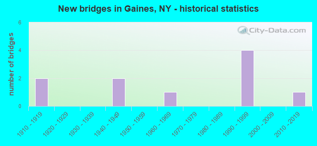
- New bridges - historical statistics
- 21910-1919
- 21940-1949
- 11960-1969
- 41990-1999
- 12010-2019

- Reconstructed bridges - Historical Statistics
- 11980-1989
- 11990-1999
- 02000-2009
- 02010-2019
- 12020-2022

- Bridge Condition - Deck
- 50.0%Very good
- 25.0%Satisfactory
- 25.0%Fair

- Bridge Condition - Superstructure
- 20.0%Excellent
- 40.0%Good
- 20.0%Satisfactory
- 20.0%Fair

- Bridge Condition - Substructure
- 60.0%Very good
- 20.0%Satisfactory
- 20.0%Fair

- Bridge Condition - Channel
- 30.0%Very good
- 20.0%Good
- 10.0%Satisfactory
- 30.0%Fair
- 10.0%Poor

- Bridge Condition - Culverts
- 20.0%Very good
- 80.0%Good
Find on map >> Show street view
Structure Number: 103643, Location: 2.6MI W JCT RTS 104 + 279 (Lat: 43.277436, Lng: -78.265400), Route carried "on" structure: State highway 104, Year Built: 1964, Status: Open, Structure Length: 1.10m (3.61ft), Average Daily Traffic: 2,732 (year 2018), Truck Traffic: 11%, Average Future Daily Traffic: 2,757 (year 2040), Design Load: H 20, Features Intersected: OTTER CREEK
Minimum Vertical Clearance: 30+ m (98+ ft), Kilometerpoint: 16.734, Lanes on structure: 2, Base Highway Network: Yes, Owner: State Highway Agency, Approaching Roadway Width: 13.4m (44.0ft), Skew: 1 degrees, Material/Design: Concrete, Design/Construction: Culvert, Number Of Spans In Main Unit: 2, Length of Maximum Span: 4.5m (14.8ft)
Condition: Channel: Poor, Culverts: Good, Structural Evaluation: Better than present minimum criteria, Waterway Adequacy: High priority of corrective action, Approach Roadway Alignment: Equal to present minimum criteria, Length Of Structure Improvement: 1.09m (3.58ft), Designated Inspection Frequency: Every 24 months, Inspection Date: August 2020, Bridge Improvement Cost: $520,000, Roadway Improvement Cost: $304,000, Total Project Cost: $824,000 ( Estimate for 2021), Wearing Surface/Protective System: Wearing Surface: Bituminous
Find on map >> Show street view
Structure Number: 331935, Location: 2.2 MI WEST OF BROCKVILLE (Lat: 43.260697, Lng: -78.135517), Route carried "on" structure: County highway , Year Built: 1999, Status: Open, Structure Length: 1.04m (3.41ft), Average Daily Traffic: 215 (year 2017), Truck Traffic: 10%, Average Future Daily Traffic: 301 (year 2037), Design Load: HS 25 or greater, Features Intersected: W BR SANDY CREEK, Facility Carried by Structure: DENSMORE ROAD
Minimum Vertical Clearance: 30+ m (98+ ft), Kilometerpoint: 2.027, Lanes on structure: 2, Owner: County Highway Agency, Approaching Roadway Width: 7.3m (24.0ft), Material/Design: Concrete, Design/Construction: Culvert, Number Of Spans In Main Unit: 1, Length of Maximum Span: 9.7m (31.8ft), Curb-To-Curb Width: 7.5m (24.6ft), Out-to-Out Width: 8.4m (27.6ft)
Condition: Channel: Very good, Culverts: Good, Operating Rating: 79.5 metric tons, Method Used To Determine Operating Rating: Field evaluation and documented engineering judgment, Inventory Rating: 40.8 metric tons, Method Used To Determine Inventory Rating: Field evaluation and documented engineering judgment, Structural Evaluation: Better than present minimum criteria, Deck Geometry: Somewhat better than minimum adequacy, Waterway Adequacy: Better than present minimum criteria, Approach Roadway Alignment: Equal to present desirable criteria, Length Of Structure Improvement: 1.03m (3.38ft), Designated Inspection Frequency: Every 24 months, Inspection Date: May 2021, Bridge Improvement Cost: $175,000, Roadway Improvement Cost: $102,000, Total Project Cost: $277,000 ( Estimate for 2021)
Find on map >> Show street view
Structure Number: 331936, Location: 2.3 MI NE ALBION (Lat: 43.255689, Lng: -78.149339), Route carried "on" structure: Other road , Year Built: 1997, Status: Open, Structure Length: 0.67m (2.20ft), Average Daily Traffic: 229 (year 2017), Truck Traffic: 2%, Average Future Daily Traffic: 321 (year 2037), Design Load: HS 25 or greater, Features Intersected: W BR SANDY CREEK, Facility Carried by Structure: KEITEL ROAD
Minimum Vertical Clearance: 30+ m (98+ ft), Kilometerpoint: 0.322, Lanes on structure: 2, Owner: County Highway Agency, Approaching Roadway Width: 7.9m (25.9ft), Material/Design: Concrete, Design/Construction: Culvert, Number Of Spans In Main Unit: 1, Length of Maximum Span: 6.0m (19.7ft)
Condition: Channel: Good, Culverts: Good, Inventory Rating: 73.5 metric tons, Method Used To Determine Inventory Rating: Load Factor (LF), Structural Evaluation: Better than present minimum criteria, Waterway Adequacy: Equal to present minimum criteria, Approach Roadway Alignment: Equal to present desirable criteria, Length Of Structure Improvement: 0.67m (2.20ft), Designated Inspection Frequency: Every 24 months, Inspection Date: May 2021, Bridge Improvement Cost: $130,000, Roadway Improvement Cost: $76,000, Total Project Cost: $206,000 ( Estimate for 2021)
Find on map >> Show street view
Structure Number: 331937, Location: 0.8 MI N EAGLE HARBOR (Lat: 43.263647, Lng: -78.252661), Route carried "on" structure: County highway , Year Built: 2010, Status: Open, Structure Length: 1.04m (3.41ft), Average Daily Traffic: 1,046 (year 2017), Truck Traffic: 6%, Average Future Daily Traffic: 1,464 (year 2037), Design Load: HS 25 or greater, Features Intersected: OTTER CREEK, Facility Carried by Structure: EGL HBR WATERPORT
Minimum Vertical Clearance: 30+ m (98+ ft), Kilometerpoint: 1.432, Lanes on structure: 2, Owner: County Highway Agency, Approaching Roadway Width: 8.5m (27.9ft), Material/Design: Concrete, Design/Construction: Culvert, Number Of Spans In Main Unit: 1, Length of Maximum Span: 9.7m (31.8ft)
Condition: Channel: Satisfactory, Culverts: Very good, Operating Rating: 79.5 metric tons, Method Used To Determine Operating Rating: Field evaluation and documented engineering judgment, Inventory Rating: 40.8 metric tons, Method Used To Determine Inventory Rating: Field evaluation and documented engineering judgment, Structural Evaluation: Equal to present desirable criteria, Waterway Adequacy: Better than present minimum criteria, Approach Roadway Alignment: Equal to present desirable criteria, Length Of Structure Improvement: 1.03m (3.38ft), Designated Inspection Frequency: Every 24 months, Inspection Date: November 2020, Bridge Improvement Cost: $420,000, Roadway Improvement Cost: $246,000, Total Project Cost: $665,000 ( Estimate for 2021)
Find on map >> Show street view
Structure Number: 331938, Location: 2.0 MI S KENT (Lat: 43.301411, Lng: -78.135533), Route carried "on" structure: County highway , Year Built: 1940, Year Reconstructed: 1989, Status: Open, Structure Length: 0.94m (3.08ft), Average Daily Traffic: 601 (year 2017), Truck Traffic: 8%, Average Future Daily Traffic: 841 (year 2037), Design Load: HS 20, Features Intersected: MARSH CREEK, Facility Carried by Structure: KENT RD.CR 11
Minimum Vertical Clearance: 30+ m (98+ ft), Kilometerpoint: 6.581, Lanes on structure: 2, Owner: County Highway Agency, Approaching Roadway Width: 6.7m (22.0ft), Material/Design: Concrete, Design/Construction: Box Beam or Girders - Multiple, Number Of Spans In Main Unit: 1, Length of Maximum Span: 8.8m (28.9ft), Curb-To-Curb Width: 8.5m (27.9ft), Out-to-Out Width: 9.1m (29.9ft)
Condition: Deck: Satisfactory, Superstructure: Fair, Substructure: Satisfactory, Channel: Fair, Operating Rating: 36.0 metric tons, Method Used To Determine Operating Rating: Load and Resistance Factor Rating (LRFR) rating reported by rating factor(RF) method using HL-93 loadings, Inventory Rating: 27.9 metric tons, Method Used To Determine Inventory Rating: Load and Resistance Factor Rating (LRFR) rating reported by rating factor(RF) method using HL-93 loadings, Structural Evaluation: Somewhat better than minimum adequacy, Deck Geometry: Somewhat better than minimum adequacy, Waterway Adequacy: Better than present minimum criteria, Approach Roadway Alignment: Equal to present desirable criteria, Length Of Structure Improvement: 0.94m (3.08ft), Designated Inspection Frequency: Every 24 months, Inspection Date: July 2020, Bridge Improvement Cost: $241,000, Roadway Improvement Cost: $141,000, Total Project Cost: $382,000 ( Estimate for 2021), Wearing Surface/Protective System: Wearing Surface: Bituminous, Membrane: Preformed Fabric
Find on map >> Show street view
Structure Number: 331939, Location: 1.5 MI SOUTH OF KENT (Lat: 43.305822, Lng: -78.135492), Route carried "on" structure: County highway , Year Built: 1940, Status: Open, Structure Length: 0.98m (3.22ft), Average Daily Traffic: 601 (year 2017), Truck Traffic: 8%, Average Future Daily Traffic: 841 (year 2037), Features Intersected: MARSH CREEK, Facility Carried by Structure: COUNTY ROAD 11
Minimum Vertical Clearance: 30+ m (98+ ft), Kilometerpoint: 7.031, Lanes on structure: 2, Owner: County Highway Agency, Approaching Roadway Width: 6.4m (21.0ft), Skew: 3 degrees, Material/Design: Steel, Design/Construction: Stringer/Multi-beam, Number Of Spans In Main Unit: 1, Length of Maximum Span: 9.4m (30.8ft), Curb-To-Curb Width: 7.4m (24.3ft), Out-to-Out Width: 8.3m (27.2ft)
Condition: Deck: Fair, Superstructure: Satisfactory, Substructure: Fair, Channel: Fair, Operating Rating: 52.6 metric tons, Method Used To Determine Operating Rating: Load Factor (LF), Inventory Rating: 20.9 metric tons, Method Used To Determine Inventory Rating: Load Factor (LF), Structural Evaluation: Somewhat better than minimum adequacy, Deck Geometry: Meets minimum limits, Waterway Adequacy: Meets minimum limits, Approach Roadway Alignment: Equal to present desirable criteria, Length Of Structure Improvement: 0.97m (3.18ft), Designated Inspection Frequency: Every 24 months, Inspection Date: July 2020, Bridge Improvement Cost: $341,000, Roadway Improvement Cost: $200,000, Total Project Cost: $541,000 ( Estimate for 2021), Deck Structure Type: Concrete Cast-file-Place, Wearing Surface/Protective System: Wearing Surface: Bituminous
Find on map >> Show street view
Structure Number: 33194, Location: 1.3 MI S WATERPORT (Lat: 43.298067, Lng: -78.251383), Route carried "on" structure: County highway , Year Built: 1999, Status: Open, Structure Length: 1.01m (3.31ft), Average Daily Traffic: 724 (year 2017), Truck Traffic: 8%, Average Future Daily Traffic: 1,014 (year 2037), Design Load: HS 25 or greater, Features Intersected: OTTER CREEK, Facility Carried by Structure: EGL HBR-WATERPORT
Minimum Vertical Clearance: 30+ m (98+ ft), Kilometerpoint: 2.381, Lanes on structure: 2, Owner: County Highway Agency, Approaching Roadway Width: 6.4m (21.0ft), Material/Design: Concrete, Design/Construction: Frame, Number Of Spans In Main Unit: 1, Length of Maximum Span: 8.5m (27.9ft), Curb-To-Curb Width: 7.3m (24.0ft), Out-to-Out Width: 8.4m (27.6ft)
Condition: Superstructure: Good, Substructure: Very good, Channel: Good, Operating Rating: 78.7 metric tons, Method Used To Determine Operating Rating: Field evaluation and documented engineering judgment, Inventory Rating: 40.8 metric tons, Method Used To Determine Inventory Rating: Field evaluation and documented engineering judgment, Structural Evaluation: Better than present minimum criteria, Deck Geometry: Meets minimum limits, Waterway Adequacy: Somewhat better than minimum adequacy, Approach Roadway Alignment: Equal to present desirable criteria, Length Of Structure Improvement: 1.09m (3.58ft), Designated Inspection Frequency: Every 24 months, Inspection Date: November 2021, Bridge Improvement Cost: $239,000, Roadway Improvement Cost: $140,000, Total Project Cost: $379,000 ( Estimate for 2021), Wearing Surface/Protective System: Wearing Surface: Bituminous
Find on map >> Show street view
Structure Number: 336189, Location: 1.4 MI NE ALBION (Lat: 43.254058, Lng: -78.165856), Route carried "on" structure: Other road , Year Built: 1992, Status: Open, Structure Length: 0.70m (2.30ft), Average Daily Traffic: 484 (year 2017), Truck Traffic: 2%, Average Future Daily Traffic: 678 (year 2037), Design Load: HS 20, Features Intersected: W.BRA.SANDY CREEK, Facility Carried by Structure: BUTTS ROAD
Minimum Vertical Clearance: 30+ m (98+ ft), Kilometerpoint: 0.177, Lanes on structure: 2, Owner: County Highway Agency, Approaching Roadway Width: 8.5m (27.9ft), Material/Design: Concrete continuous, Design/Construction: Culvert, Number Of Spans In Main Unit: 2, Length of Maximum Span: 3.3m (10.8ft)
Condition: Channel: Fair, Culverts: Good, Operating Rating: 74.9 metric tons, Method Used To Determine Operating Rating: Field evaluation and documented engineering judgment, Inventory Rating: 32.7 metric tons, Method Used To Determine Inventory Rating: Field evaluation and documented engineering judgment, Structural Evaluation: Better than present minimum criteria, Waterway Adequacy: Meets minimum limits, Approach Roadway Alignment: Equal to present desirable criteria, Length Of Structure Improvement: 0.70m (2.30ft), Designated Inspection Frequency: Every 24 months, Inspection Date: September 2020, Bridge Improvement Cost: $107,000, Roadway Improvement Cost: $63,000, Total Project Cost: $170,000 ( Estimate for 2021)
Find on map >> Show street view
Structure Number: 444514, Location: 1.6MI W JCT BARGE C+RTE98 (Lat: 43.255383, Lng: -78.223392), Route carried "on" structure: Alternate Other road , Year Built: 1912, Year Reconstructed: 2020, Status: Posted for load-capacity, Structure Length: 7.16m (23.49ft), Average Daily Traffic: 936 (year 2017), Truck Traffic: 15%, Average Future Daily Traffic: 976 (year 2040), Features Intersected: Erie Canal Heritage Trai, Facility Carried by Structure: GAINES BASIN ROAD
Minimum Vertical Clearance: 4.72m (15.49ft), Kilometerpoint: 0.386, Lanes on structure: 1, Owner: State Highway Agency, Approaching Roadway Width: 5.5m (18.0ft), Skew: 3 degrees, Navigation Control: Yes ( Vertical Clearance: 4.6m (15.1ft), Horizontal Clearance: 22.8m (74.8ft)), Material/Design: Steel, Design/Construction: Truss - Thru, Number Of Spans In Main Unit: 1, Number Of Approach Spans: 2, Length of Maximum Span: 55.8m (183.1ft), Curb-To-Curb Width: 4.4m (14.4ft), Out-to-Out Width: 5.1m (16.7ft)
Condition: Deck: Very good, Superstructure: Excellent, Substructure: Very good, Channel: Very good, Operating Rating: 39.0 metric tons, Method Used To Determine Operating Rating: Load Factor (LF), Inventory Rating: 22.7 metric tons, Method Used To Determine Inventory Rating: Load Factor (LF), Structural Evaluation: Equal to present minimum criteria, Deck Geometry: High priority of replacement, Waterway Adequacy: Equal to present minimum criteria, Approach Roadway Alignment: Meets minimum limits, Length Of Structure Improvement: 7.16m (23.49ft), Designated Inspection Frequency: Every 24 months, Critical Feature Inspection Frequency: Every 24 months, Inspection Date: December 2020, Critical Feature Inspection Date: December 2020, Bridge Improvement Cost: $3,125,000, Roadway Improvement Cost: $1,830,000, Total Project Cost: $4,955,000 ( Estimate for 2021)
Find on map >> Show street view
Structure Number: 444515, Location: 3 MI W JCT BRG CNL & SH98 (Lat: 43.251739, Lng: -78.253133), Route carried "on" structure: Other road , Year Built: 1910, Year Reconstructed: 1997, Status: Posted for load-capacity, Structure Length: 4.39m (14.40ft), Average Daily Traffic: 925 (year 2017), Truck Traffic: 7%, Average Future Daily Traffic: 1,295 (year 2037), Design Load: HS 20, Features Intersected: ERIE CANAL, Facility Carried by Structure: EAGLE HARBOR ROAD
Minimum Vertical Clearance: 30+ m (98+ ft), Kilometerpoint: 1.722, Lanes on structure: 2, Owner: State Highway Agency, Approaching Roadway Width: 5.5m (18.0ft), Skew: 2 degrees, Navigation Control: Yes ( Vertical Clearance: 5.1m (16.7ft), Horizontal Clearance: 26.2m (86.0ft)), Material/Design: Steel, Design/Construction: Movable - Lift, Number Of Spans In Main Unit: 1, Number Of Approach Spans: 2, Length of Maximum Span: 37.4m (122.7ft), Curb or Sidewalk Widths: Left: 1.3m (4.3ft), Right: 1.3m (4.3ft), Curb-To-Curb Width: 5.7m (18.7ft), Out-to-Out Width: 6.2m (20.3ft)
Condition: Deck: Very good, Superstructure: Good, Substructure: Very good, Channel: Very good, Operating Rating: 39.9 metric tons, Method Used To Determine Operating Rating: Load Factor (LF), Inventory Rating: 23.6 metric tons, Method Used To Determine Inventory Rating: Load Factor (LF), Structural Evaluation: Equal to present minimum criteria, Deck Geometry: High priority of replacement, Waterway Adequacy: Equal to present minimum criteria, Approach Roadway Alignment: Somewhat better than minimum adequacy, Length Of Structure Improvement: 4.38m (14.37ft), Designated Inspection Frequency: Every 24 months, Critical Feature Inspection Frequency: Every 24 months, Inspection Date: August 2021, Critical Feature Inspection Date: August 2021, Bridge Improvement Cost: $3,705,000, Roadway Improvement Cost: $2,169,000, Total Project Cost: $5,874,000 ( Estimate for 2021), Deck Structure Type: Concrete Cast-file-Place, Wearing Surface/Protective System: Wearing Surface: Integral Concrete, Deck Protection: Epoxy Coated Reinforcing