Bridge Statistics for Garden City, Kansas (KS)
Condition, Traffic, Stress, Structural Evaluation, Project Costs
- National Bridge Inventory (NBI) Statistics
- 37Number of bridges
- 482ft / 147mTotal length
- $1,300,000Total costs
- 167,246Total average daily traffic
- 24,126Total average daily truck traffic
- National Bridge Inventory (NBI) Registered Bridges for Garden City
- No street view available for this location
- New bridges - historical statistics
- 81950-1959
- 101970-1979
- 31980-1989
- 61990-1999
- 52000-2009
- 52010-2019
- Bridge Condition - Deck
- 83.3%Good
- 8.3%Satisfactory
- 8.3%Fair
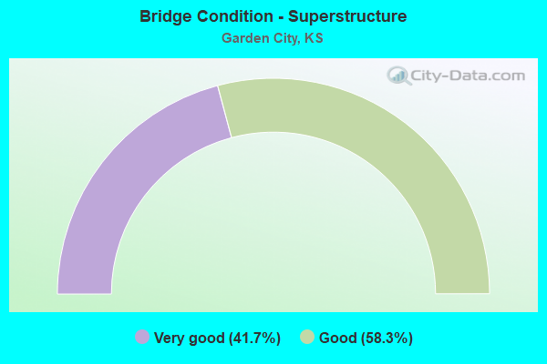
- Bridge Condition - Superstructure
- 41.7%Very good
- 58.3%Good
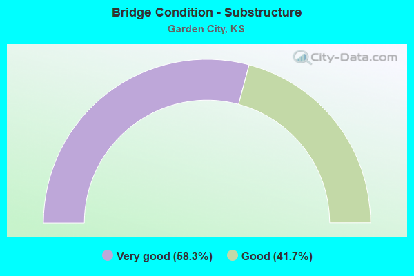
- Bridge Condition - Substructure
- 58.3%Very good
- 41.7%Good
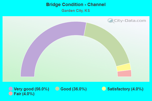
- Bridge Condition - Channel
- 56.0%Very good
- 36.0%Good
- 4.0%Satisfactory
- 4.0%Fair
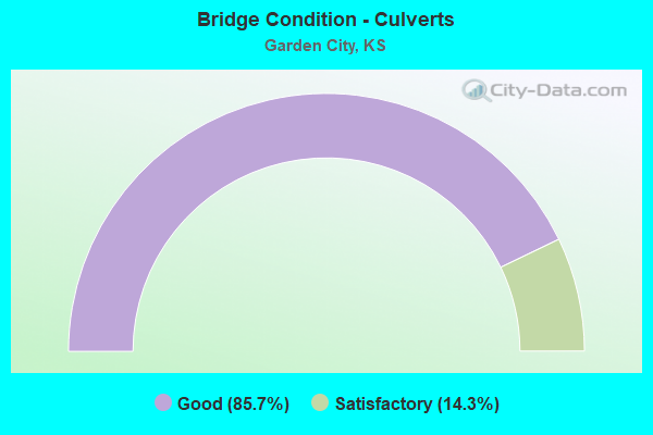
- Bridge Condition - Culverts
- 85.7%Good
- 14.3%Satisfactory
Find on map >> Show street view
Structure Number: 28014, Location: 2.0N 2.0E OF GARDEN CITY (Lat: 38.012650, Lng: -100.829106), Route carried "on" structure: County highway 1636, Year Built: 1953, Status: Open, Structure Length: 0.91m (2.99ft), Average Daily Traffic: 300 (year 2018), Truck Traffic: 25%, Average Future Daily Traffic: 360 (year 2041), Design Load: H 15, Features Intersected: DRAINAGE DITCH
Minimum Vertical Clearance: 30.47m (99.97ft), Kilometerpoint: 0.000, Lanes on structure: 2, Owner: County Highway Agency, Approaching Roadway Width: 7.9m (25.9ft), Skew: 3 degrees, Material/Design: Concrete, Design/Construction: Culvert, Number Of Spans In Main Unit: 3, Length of Maximum Span: 3.0m (9.8ft), Curb-To-Curb Width: 7.5m (24.6ft), Out-to-Out Width: 8.5m (27.9ft)
Condition: Channel: Good, Culverts: Good, Operating Rating: 22.1 metric tons, Method Used To Determine Operating Rating: Load Factor (LF), Inventory Rating: 12.7 metric tons, Method Used To Determine Inventory Rating: Load Factor (LF), Structural Evaluation: Meets minimum limits, Deck Geometry: Somewhat better than minimum adequacy, Waterway Adequacy: Better than present minimum criteria, Approach Roadway Alignment: Equal to present desirable criteria, Designated Inspection Frequency: Every 24 months, Inspection Date: November 2021
Find on map >> Show street view
Structure Number: 280425005746, Location: 1.7E, 1.5N of Holcomb (Lat: 38.011206, Lng: -100.957139), Route carried "on" structure: County highway , Year Built: 2013, Status: Posted for load, Structure Length: 0.85m (2.79ft), Average Daily Traffic: 130 (year 2018), Truck Traffic: 5%, Average Future Daily Traffic: 200 (year 2041), Design Load: HL 93, Features Intersected: FARMER'S CANAL, Facility Carried by Structure: LOCAL CHMELKA RD.
Minimum Vertical Clearance: 30.47m (99.97ft), Kilometerpoint: 0.000, Lanes on structure: 2, Owner: County Highway Agency, Approaching Roadway Width: 6.7m (22.0ft), Material/Design: Concrete, Design/Construction: Culvert, Number Of Spans In Main Unit: 1, Length of Maximum Span: 7.9m (25.9ft), Curb-To-Curb Width: 7.6m (24.9ft), Out-to-Out Width: 9.1m (29.9ft)
Condition: Channel: Good, Culverts: Good, Operating Rating: 42.1 metric tons, Method Used To Determine Operating Rating: Load and Resistance Factor Rating (LRFR) rating reported by rating factor(RF) method using HL-93 loadings, Inventory Rating: 32.4 metric tons, Method Used To Determine Inventory Rating: Load and Resistance Factor Rating (LRFR) rating reported by rating factor(RF) method using HL-93 loadings, Structural Evaluation: Better than present minimum criteria, Deck Geometry: Somewhat better than minimum adequacy, Waterway Adequacy: Better than present minimum criteria, Approach Roadway Alignment: Equal to present desirable criteria, Bridge Posting: Required (Relationship of Operating Rating to Maximum Legal Load: 10.0 - 19.9% below), Designated Inspection Frequency: Every 24 months, Inspection Date: November 2021
Find on map >> Show street view
Structure Number: 280427005746, Location: 2.7E 1.4N OF HOLCOMB (Lat: 38.009903, Lng: -100.938794), Route carried "on" structure: County highway , Year Built: 2006, Status: Open, Structure Length: 0.87m (2.85ft), Average Daily Traffic: 17 (year 2018), Truck Traffic: 20%, Average Future Daily Traffic: 15 (year 2041), Design Load: HS 20, Features Intersected: FARMER'S CANAL, Facility Carried by Structure: LOCAL SHERLOCK RD
Minimum Vertical Clearance: 30.47m (99.97ft), Kilometerpoint: 0.000, Lanes on structure: 2, Owner: County Highway Agency, Approaching Roadway Width: 8.5m (27.9ft), Material/Design: Concrete, Design/Construction: Culvert, Number Of Spans In Main Unit: 2, Length of Maximum Span: 4.3m (14.1ft), Curb-To-Curb Width: 8.5m (27.9ft), Out-to-Out Width: 9.0m (29.5ft)
Condition: Channel: Satisfactory, Culverts: Good, Operating Rating: 80.9 metric tons, Method Used To Determine Operating Rating: Load Factor (LF), Inventory Rating: 48.1 metric tons, Method Used To Determine Inventory Rating: Load Factor (LF), Structural Evaluation: Better than present minimum criteria, Deck Geometry: Better than present minimum criteria, Waterway Adequacy: Better than present minimum criteria, Approach Roadway Alignment: Equal to present desirable criteria, Designated Inspection Frequency: Every 24 months, Inspection Date: November 2021
Find on map >> Show street view
Structure Number: 280429005748, Location: 3.7E 1.1N OF HOLCOMB (Lat: 38.006181, Lng: -100.920214), Route carried "on" structure: Other road , Year Built: 2013, Status: Posted for load, Structure Length: 0.85m (2.79ft), Average Daily Traffic: 75 (year 2018), Truck Traffic: 15%, Average Future Daily Traffic: 150 (year 2041), Design Load: HL 93, Features Intersected: FARMER'S CANAL, Facility Carried by Structure: LOCAL ANDERSON RD
Minimum Vertical Clearance: 30.47m (99.97ft), Kilometerpoint: 0.000, Lanes on structure: 2, Owner: County Highway Agency, Approaching Roadway Width: 7.9m (25.9ft), Material/Design: Concrete, Design/Construction: Culvert, Number Of Spans In Main Unit: 1, Length of Maximum Span: 8.5m (27.9ft), Curb-To-Curb Width: 9.1m (29.9ft), Out-to-Out Width: 9.1m (29.9ft)
Condition: Channel: Good, Culverts: Good, Operating Rating: 42.1 metric tons, Method Used To Determine Operating Rating: Load and Resistance Factor Rating (LRFR) rating reported by rating factor(RF) method using HL-93 loadings, Inventory Rating: 32.4 metric tons, Method Used To Determine Inventory Rating: Load and Resistance Factor Rating (LRFR) rating reported by rating factor(RF) method using HL-93 loadings, Structural Evaluation: Better than present minimum criteria, Deck Geometry: Better than present minimum criteria, Waterway Adequacy: Better than present minimum criteria, Approach Roadway Alignment: Equal to present desirable criteria, Bridge Posting: Required (Relationship of Operating Rating to Maximum Legal Load: 10.0 - 19.9% below), Designated Inspection Frequency: Every 24 months, Inspection Date: November 2021
Find on map >> Show street view
Structure Number: 28043950577, Location: 0.7E OF GARDEN CITY (Lat: 37.989328, Lng: -100.825192), Route carried "on" structure: County highway , Year Built: 1997, Status: Open, Structure Length: 0.73m (2.40ft), Average Daily Traffic: 630 (year 2018), Truck Traffic: 15%, Average Future Daily Traffic: 1,000 (year 2041), Design Load: HS 20, Features Intersected: DRAINAGE DITCH NO.2, Facility Carried by Structure: MARY STREET
Minimum Vertical Clearance: 30.47m (99.97ft), Kilometerpoint: 0.000, Lanes on structure: 2, Owner: County Highway Agency, Approaching Roadway Width: 7.4m (24.3ft), Skew: 3 degrees, Material/Design: Concrete, Design/Construction: Culvert, Number Of Spans In Main Unit: 2, Length of Maximum Span: 3.5m (11.5ft), Curb-To-Curb Width: 13.3m (43.6ft), Out-to-Out Width: 13.7m (44.9ft)
Condition: Channel: Good, Culverts: Good, Operating Rating: 84.2 metric tons, Method Used To Determine Operating Rating: Load Factor (LF), Inventory Rating: 49.9 metric tons, Method Used To Determine Inventory Rating: Load Factor (LF), Structural Evaluation: Better than present minimum criteria, Deck Geometry: Superior to present desirable criteria, Waterway Adequacy: Equal to present desirable criteria, Approach Roadway Alignment: Equal to present desirable criteria, Designated Inspection Frequency: Every 24 months, Inspection Date: November 2021
Find on map >> Show street view
Structure Number: 28044050579, Location: 1.25E OF GARDEN CITY (Lat: 37.974781, Lng: -100.816247), Route carried "on" structure: County highway , Year Built: 1996, Status: Open, Structure Length: 0.73m (2.40ft), Average Daily Traffic: 575 (year 2018), Truck Traffic: 10%, Average Future Daily Traffic: 800 (year 2041), Design Load: HS 20, Features Intersected: DRAINAGE DITCH NO.2, Facility Carried by Structure: SCHULMAN AVE.
Minimum Vertical Clearance: 30.47m (99.97ft), Kilometerpoint: 0.000, Lanes on structure: 2, Owner: County Highway Agency, Approaching Roadway Width: 7.9m (25.9ft), Skew: 3 degrees, Material/Design: Concrete, Design/Construction: Culvert, Number Of Spans In Main Unit: 2, Length of Maximum Span: 3.5m (11.5ft), Curb-To-Curb Width: 12.2m (40.0ft), Out-to-Out Width: 13.7m (44.9ft)
Condition: Channel: Very good, Culverts: Good, Operating Rating: 88.9 metric tons, Method Used To Determine Operating Rating: Load Factor (LF), Inventory Rating: 52.6 metric tons, Method Used To Determine Inventory Rating: Load Factor (LF), Structural Evaluation: Better than present minimum criteria, Deck Geometry: Equal to present desirable criteria, Waterway Adequacy: Equal to present desirable criteria, Approach Roadway Alignment: Equal to present desirable criteria, Designated Inspection Frequency: Every 24 months, Inspection Date: November 2021
Find on map >> Show street view
Structure Number: 280441005802, Location: 1.5E & .5N OF GARDEN CITY (Lat: 37.967231, Lng: -100.810622), Route carried "on" structure: County highway , Year Built: 1997, Status: Open, Structure Length: 0.95m (3.12ft), Average Daily Traffic: 350 (year 2018), Truck Traffic: 8%, Average Future Daily Traffic: 600 (year 2041), Design Load: HS 20, Features Intersected: DRAINAGE DITCH NO.2, Facility Carried by Structure: FARMLAND ROAD
Minimum Vertical Clearance: 30.47m (99.97ft), Kilometerpoint: 0.000, Lanes on structure: 2, Owner: County Highway Agency, Approaching Roadway Width: 7.7m (25.3ft), Material/Design: Concrete, Design/Construction: Culvert, Number Of Spans In Main Unit: 3, Length of Maximum Span: 3.0m (9.8ft), Curb-To-Curb Width: 11.5m (37.7ft), Out-to-Out Width: 13.7m (44.9ft)
Condition: Channel: Very good, Culverts: Good, Operating Rating: 78.3 metric tons, Method Used To Determine Operating Rating: Load Factor (LF), Inventory Rating: 46.3 metric tons, Method Used To Determine Inventory Rating: Load Factor (LF), Structural Evaluation: Better than present minimum criteria, Deck Geometry: Superior to present desirable criteria, Waterway Adequacy: Equal to present desirable criteria, Approach Roadway Alignment: Equal to present desirable criteria, Designated Inspection Frequency: Every 24 months, Inspection Date: November 2021
Find on map >> Show street view
Structure Number: 40985028140658, Location: 100'E OF US 50-83 (Lat: 37.967664, Lng: -100.839136), Route carried "on" structure: City street 1406, Year Built: 1983, Status: Open, Structure Length: 1.30m (4.27ft), Average Daily Traffic: 6,355 (year 2018), Truck Traffic: 4%, Average Future Daily Traffic: 7,625 (year 2041), Design Load: H 20, Features Intersected: DRAINAGE DTCH. #1, Facility Carried by Structure: SPRUCE ST.
Minimum Vertical Clearance: 30.47m (99.97ft), Kilometerpoint: 0.000, Lanes on structure: 2, Owner: City or Municipal Highway Agency, Approaching Roadway Width: 11.8m (38.7ft), Material/Design: Concrete, Design/Construction: Culvert, Number Of Spans In Main Unit: 5, Length of Maximum Span: 2.4m (7.9ft), Curb-To-Curb Width: 12.2m (40.0ft), Out-to-Out Width: 18.3m (60.0ft)
Condition: Channel: Very good, Culverts: Good, Operating Rating: 25.1 metric tons, Method Used To Determine Operating Rating: Load Factor (LF), Inventory Rating: 15.0 metric tons, Method Used To Determine Inventory Rating: Load Factor (LF), Structural Evaluation: High priority of replacement, Deck Geometry: Somewhat better than minimum adequacy, Waterway Adequacy: Equal to present desirable criteria, Approach Roadway Alignment: Equal to present desirable criteria, Length Of Structure Improvement: 1.83m (6.00ft), Designated Inspection Frequency: Every 24 months, Inspection Date: November 2021, Bridge Improvement Cost: $390,000, Roadway Improvement Cost: $170,000, Total Project Cost: $560,000 ( Estimate for 2021), Wearing Surface/Protective System: Wearing Surface: Bituminous
Find on map >> Show street view
Structure Number: 409850281409434, Location: EIGHTH ST AT WILLOW BROOK (Lat: 37.982183, Lng: -100.874744), Route carried "on" structure: City street 1409, Year Built: 1953, Status: Open, Structure Length: 0.78m (2.56ft), Average Daily Traffic: 3,680 (year 2018), Truck Traffic: 5%, Average Future Daily Traffic: 4,415 (year 2041), Design Load: H 20, Features Intersected: DRAINAGE DITCH #1, Facility Carried by Structure: EIGHTH STREET
Minimum Vertical Clearance: 30.47m (99.97ft), Kilometerpoint: 0.000, Lanes on structure: 2, Owner: City or Municipal Highway Agency, Approaching Roadway Width: 11.8m (38.7ft), Material/Design: Concrete, Design/Construction: Culvert, Number Of Spans In Main Unit: 3, Length of Maximum Span: 2.4m (7.9ft), Curb or Sidewalk Widths: Left: 1.5m (4.9ft), Right: 1.5m (4.9ft), Curb-To-Curb Width: 12.2m (40.0ft), Out-to-Out Width: 15.9m (52.2ft)
Condition: Channel: Very good, Culverts: Satisfactory, Operating Rating: 23.5 metric tons, Method Used To Determine Operating Rating: Load Factor (LF), Inventory Rating: 14.0 metric tons, Method Used To Determine Inventory Rating: Load Factor (LF), Structural Evaluation: Meets minimum limits, Deck Geometry: Equal to present minimum criteria, Waterway Adequacy: Equal to present desirable criteria, Approach Roadway Alignment: Equal to present desirable criteria, Designated Inspection Frequency: Every 24 months, Inspection Date: November 2021
Find on map >> Show street view
Structure Number: 409850281411435, Location: BETWEEN JOHNSON & HAMLINE (Lat: 37.982342, Lng: -100.869336), Route carried "on" structure: City street 1411, Year Built: 1953, Status: Open, Structure Length: 0.78m (2.56ft), Average Daily Traffic: 3,705 (year 2018), Truck Traffic: 5%, Average Future Daily Traffic: 4,445 (year 2041), Design Load: H 20, Features Intersected: DRAINAGE DITCH #1, Facility Carried by Structure: MAIN STREET
Minimum Vertical Clearance: 30.47m (99.97ft), Kilometerpoint: 0.000, Lanes on structure: 2, Owner: City or Municipal Highway Agency, Approaching Roadway Width: 11.8m (38.7ft), Material/Design: Concrete, Design/Construction: Culvert, Number Of Spans In Main Unit: 3, Length of Maximum Span: 2.4m (7.9ft), Curb or Sidewalk Widths: Left: 1.5m (4.9ft), Right: 1.5m (4.9ft), Curb-To-Curb Width: 12.2m (40.0ft), Out-to-Out Width: 15.9m (52.2ft)
Condition: Channel: Very good, Culverts: Satisfactory, Operating Rating: 30.7 metric tons, Method Used To Determine Operating Rating: Load Factor (LF), Inventory Rating: 18.2 metric tons, Method Used To Determine Inventory Rating: Load Factor (LF), Structural Evaluation: Somewhat better than minimum adequacy, Deck Geometry: Equal to present minimum criteria, Waterway Adequacy: Equal to present desirable criteria, Approach Roadway Alignment: Better than present minimum criteria, Length Of Structure Improvement: 0.79m (2.59ft), Designated Inspection Frequency: Every 24 months, Inspection Date: November 2021, Wearing Surface/Protective System: Wearing Surface: Bituminous
Find on map >> Show street view
Structure Number: 409850281415436, Location: BETWEEN JOHNSON & HAMLINE (Lat: 37.981714, Lng: -100.865583), Route carried "on" structure: City street 1415, Year Built: 1953, Status: Open, Structure Length: 0.78m (2.56ft), Average Daily Traffic: 5,940 (year 2018), Truck Traffic: 5%, Average Future Daily Traffic: 7,125 (year 2041), Design Load: H 20, Features Intersected: DRAINAGE DITCH #1, Facility Carried by Structure: THIRD STREET
Minimum Vertical Clearance: 30.47m (99.97ft), Kilometerpoint: 0.000, Lanes on structure: 2, Owner: City or Municipal Highway Agency, Approaching Roadway Width: 11.8m (38.7ft), Material/Design: Concrete, Design/Construction: Culvert, Number Of Spans In Main Unit: 3, Length of Maximum Span: 2.4m (7.9ft), Curb or Sidewalk Widths: Left: 1.5m (4.9ft), Right: 1.5m (4.9ft), Curb-To-Curb Width: 12.2m (40.0ft), Out-to-Out Width: 15.8m (51.8ft)
Condition: Channel: Very good, Culverts: Good, Operating Rating: 30.7 metric tons, Method Used To Determine Operating Rating: Load Factor (LF), Inventory Rating: 18.2 metric tons, Method Used To Determine Inventory Rating: Load Factor (LF), Structural Evaluation: Meets minimum limits, Deck Geometry: Somewhat better than minimum adequacy, Waterway Adequacy: Equal to present desirable criteria, Approach Roadway Alignment: Equal to present desirable criteria, Designated Inspection Frequency: Every 24 months, Inspection Date: November 2021, Wearing Surface/Protective System: Wearing Surface: Bituminous
Find on map >> Show street view
Structure Number: 409850281417437, Location: BETWEEN JOHNSON & HAMLINE (Lat: 37.982117, Lng: -100.858731), Route carried "on" structure: City street 1417, Year Built: 1970, Year Reconstructed: 1978, Status: Open, Structure Length: 1.08m (3.54ft), Average Daily Traffic: 1,230 (year 2018), Truck Traffic: 5%, Average Future Daily Traffic: 1,475 (year 2041), Design Load: H 20, Features Intersected: DRAINAGE DITCH #1, Facility Carried by Structure: CENTER ST
Minimum Vertical Clearance: 30.47m (99.97ft), Kilometerpoint: 0.000, Lanes on structure: 2, Owner: City or Municipal Highway Agency, Approaching Roadway Width: 12.1m (39.7ft), Material/Design: Concrete, Design/Construction: Culvert, Number Of Spans In Main Unit: 3, Number Of Approach Spans: 1, Length of Maximum Span: 2.4m (7.9ft), Curb or Sidewalk Widths: Left: 2.7m (8.9ft), Right: 2.7m (8.9ft), Curb-To-Curb Width: 12.2m (40.0ft), Out-to-Out Width: 18.3m (60.0ft)
Condition: Channel: Very good, Culverts: Good, Operating Rating: 49.9 metric tons, Method Used To Determine Operating Rating: No rating analysis performed, Inventory Rating: 30.8 metric tons, Method Used To Determine Inventory Rating: No rating analysis performed, Structural Evaluation: Better than present minimum criteria, Deck Geometry: Better than present minimum criteria, Waterway Adequacy: Equal to present desirable criteria, Approach Roadway Alignment: Equal to present desirable criteria, Designated Inspection Frequency: Every 24 months, Inspection Date: November 2021, Wearing Surface/Protective System: Wearing Surface: Bituminous
Find on map >> Show street view
Structure Number: 409850281419438, Location: BETWEEN JOHNSON & FAIR ST (Lat: 37.981664, Lng: -100.854178), Route carried "on" structure: City street 1419, Year Built: 1975, Status: Open, Structure Length: 1.45m (4.76ft), Average Daily Traffic: 6,600 (year 2018), Truck Traffic: 5%, Average Future Daily Traffic: 7,920 (year 2041), Design Load: H 20, Features Intersected: DRAINAGE DITCH #1, Facility Carried by Structure: FLEMING ST
Minimum Vertical Clearance: 30.47m (99.97ft), Kilometerpoint: 0.000, Lanes on structure: 2, Owner: City or Municipal Highway Agency, Approaching Roadway Width: 15.8m (51.8ft), Skew: 2 degrees, Material/Design: Concrete, Design/Construction: Culvert, Number Of Spans In Main Unit: 3, Number Of Approach Spans: 2, Length of Maximum Span: 2.4m (7.9ft), Curb or Sidewalk Widths: Left: 2.4m (7.9ft), Right: 2.4m (7.9ft), Curb-To-Curb Width: 15.8m (51.8ft), Out-to-Out Width: 21.4m (70.2ft)
Condition: Channel: Very good, Culverts: Good, Operating Rating: 41.7 metric tons, Method Used To Determine Operating Rating: No rating analysis performed, Inventory Rating: 25.4 metric tons, Method Used To Determine Inventory Rating: No rating analysis performed, Structural Evaluation: Equal to present minimum criteria, Deck Geometry: Superior to present desirable criteria, Waterway Adequacy: Equal to present desirable criteria, Approach Roadway Alignment: Equal to present desirable criteria, Designated Inspection Frequency: Every 24 months, Inspection Date: November 2021, Wearing Surface/Protective System: Wearing Surface: Bituminous
Find on map >> Show street view
Structure Number: 409850281420578, Location: HARDING 50'W OF CAMPUS (Lat: 37.978117, Lng: -100.847761), Route carried "on" structure: City street 1420, Year Built: 1978, Status: Open, Structure Length: 1.10m (3.61ft), Average Daily Traffic: 1,910 (year 2018), Truck Traffic: 5%, Average Future Daily Traffic: 3,000 (year 2041), Design Load: H 20, Features Intersected: DRAINAGE DITCH #1, Facility Carried by Structure: HARDING AVENUE
Minimum Vertical Clearance: 30.47m (99.97ft), Kilometerpoint: 0.000, Lanes on structure: 2, Owner: City or Municipal Highway Agency, Approaching Roadway Width: 12.1m (39.7ft), Skew: 3 degrees, Material/Design: Steel, Design/Construction: Stringer/Multi-beam, Number Of Spans In Main Unit: 1, Length of Maximum Span: 10.1m (33.1ft), Curb or Sidewalk Widths: Left: 1.3m (4.3ft), Right: 1.3m (4.3ft), Curb-To-Curb Width: 12.2m (40.0ft), Out-to-Out Width: 15.2m (49.9ft)
Condition: Deck: Good, Superstructure: Good, Substructure: Good, Channel: Very good, Operating Rating: 26.8 metric tons, Method Used To Determine Operating Rating: Load Factor (LF), Inventory Rating: 16.0 metric tons, Method Used To Determine Inventory Rating: Load Factor (LF), Structural Evaluation: Meets minimum limits, Deck Geometry: Better than present minimum criteria, Waterway Adequacy: Equal to present desirable criteria, Approach Roadway Alignment: Equal to present desirable criteria, Designated Inspection Frequency: Every 24 months, Inspection Date: November 2021, Deck Structure Type: Concrete Cast-file-Place, Wearing Surface/Protective System: Wearing Surface: Bituminous
Find on map >> Show street view
Structure Number: 509850280000433, Location: BETWEEN CAMPBELL-HAMLINE (Lat: 37.982197, Lng: -100.879431), Route carried "on" structure: City street , Year Built: 1975, Status: Open, Structure Length: 0.87m (2.85ft), Average Daily Traffic: 7,040 (year 2018), Truck Traffic: 5%, Average Future Daily Traffic: 8,450 (year 2041), Design Load: H 20, Features Intersected: DRAINAGE DITCH #1, Facility Carried by Structure: ELEVENTH STREET
Minimum Vertical Clearance: 30.47m (99.97ft), Kilometerpoint: 0.000, Lanes on structure: 2, Owner: City or Municipal Highway Agency, Approaching Roadway Width: 11.8m (38.7ft), Material/Design: Concrete, Design/Construction: Culvert, Number Of Spans In Main Unit: 3, Length of Maximum Span: 2.7m (8.9ft), Curb or Sidewalk Widths: Left: 2.7m (8.9ft), Right: 2.7m (8.9ft), Curb-To-Curb Width: 11.8m (38.7ft), Out-to-Out Width: 18.3m (60.0ft)
Condition: Channel: Very good, Culverts: Good, Operating Rating: 25.4 metric tons, Method Used To Determine Operating Rating: Load Factor (LF), Inventory Rating: 15.0 metric tons, Method Used To Determine Inventory Rating: Load Factor (LF), Structural Evaluation: High priority of replacement, Deck Geometry: Somewhat better than minimum adequacy, Waterway Adequacy: Equal to present desirable criteria, Approach Roadway Alignment: Equal to present desirable criteria, Length Of Structure Improvement: 1.22m (4.00ft), Designated Inspection Frequency: Every 24 months, Inspection Date: November 2021, Bridge Improvement Cost: $260,000, Roadway Improvement Cost: $110,000, Total Project Cost: $370,000 ( Estimate for 2021), Wearing Surface/Protective System: Wearing Surface: Bituminous
Find on map >> Show street view
Structure Number: 509850280000579, Location: 50` W OF CAMPUS DR. (Lat: 37.977047, Lng: -100.847503), Route carried "on" structure: City street , Year Built: 1978, Status: Open, Structure Length: 0.95m (3.12ft), Average Daily Traffic: 9,570 (year 2018), Truck Traffic: 6%, Average Future Daily Traffic: 11,484 (year 2041), Design Load: H 20, Features Intersected: DRAINAGE DITCH #1, Facility Carried by Structure: COLLEGE DRIVE
Minimum Vertical Clearance: 30.47m (99.97ft), Kilometerpoint: 0.000, Lanes on structure: 2, Owner: City or Municipal Highway Agency, Approaching Roadway Width: 11.8m (38.7ft), Material/Design: Concrete, Design/Construction: Culvert, Number Of Spans In Main Unit: 3, Length of Maximum Span: 3.0m (9.8ft), Curb or Sidewalk Widths: Left: 2.8m (9.2ft), Right: 2.8m (9.2ft), Curb-To-Curb Width: 11.9m (39.0ft), Out-to-Out Width: 18.3m (60.0ft)
Condition: Channel: Very good, Culverts: Good, Operating Rating: 22.9 metric tons, Method Used To Determine Operating Rating: Load Factor (LF), Inventory Rating: 13.7 metric tons, Method Used To Determine Inventory Rating: Load Factor (LF), Structural Evaluation: High priority of replacement, Deck Geometry: Somewhat better than minimum adequacy, Waterway Adequacy: Equal to present desirable criteria, Approach Roadway Alignment: Equal to present desirable criteria, Length Of Structure Improvement: 1.22m (4.00ft), Designated Inspection Frequency: Every 24 months, Inspection Date: November 2021, Bridge Improvement Cost: $260,000, Roadway Improvement Cost: $110,000, Total Project Cost: $370,000 ( Estimate for 2021), Wearing Surface/Protective System: Wearing Surface: Bituminous
Find on map >> Show street view
Structure Number: 509850280000582, Location: S.E. EDGE OF GARDEN CITY (Lat: 37.955464, Lng: -100.829322), Route carried "on" structure: City street , Year Built: 1983, Status: Open, Structure Length: 1.56m (5.12ft), Average Daily Traffic: 90 (year 2018), Truck Traffic: 20%, Average Future Daily Traffic: 120 (year 2041), Design Load: H 20, Features Intersected: DRAINAGE DITCH #1, Facility Carried by Structure: MANSFIELD RD
Minimum Vertical Clearance: 30.47m (99.97ft), Kilometerpoint: 0.000, Lanes on structure: 2, Owner: City or Municipal Highway Agency, Approaching Roadway Width: 7.3m (24.0ft), Material/Design: Concrete, Design/Construction: Culvert, Number Of Spans In Main Unit: 6, Length of Maximum Span: 2.4m (7.9ft), Curb-To-Curb Width: 6.7m (22.0ft), Out-to-Out Width: 7.3m (24.0ft)
Condition: Channel: Good, Culverts: Good, Operating Rating: 54.5 metric tons, Method Used To Determine Operating Rating: Field evaluation and documented engineering judgment, Inventory Rating: 32.7 metric tons, Method Used To Determine Inventory Rating: Field evaluation and documented engineering judgment, Structural Evaluation: Better than present minimum criteria, Deck Geometry: Somewhat better than minimum adequacy, Waterway Adequacy: Equal to present desirable criteria, Approach Roadway Alignment: Somewhat better than minimum adequacy, Designated Inspection Frequency: Every 24 months, Inspection Date: November 2021, Wearing Surface/Protective System: Wearing Surface: Bituminous
Find on map >> Show street view
Structure Number: 999905000280021, Location: .24MI E-US50&US83 (Lat: 37.960278, Lng: -100.835000), Route carried "on" structure: US 50, Year Built: 1953, Year Reconstructed: 1983, Status: Open, Structure Length: 1.51m (4.95ft), Average Daily Traffic: 5,937 (year 2020), Truck Traffic: 14%, Average Future Daily Traffic: 8,155 (year 2041), Design Load: H 20, Features Intersected: Drainage Ditch
Minimum Vertical Clearance: 30.47m (99.97ft), Kilometerpoint: 28.360, Lanes on structure: 4, Base Highway Network: Yes, Owner: State Highway Agency, Approaching Roadway Width: 18.3m (60.0ft), Skew: 14 degrees, Material/Design: Concrete, Design/Construction: Culvert, Number Of Spans In Main Unit: 5, Length of Maximum Span: 2.4m (7.9ft), Curb-To-Curb Width: 18.3m (60.0ft), Out-to-Out Width: 50.6m (166.0ft)
Condition: Channel: Very good, Culverts: Satisfactory, Operating Rating: 24.9 metric tons, Method Used To Determine Operating Rating: Load Factor (LF), Inventory Rating: 15.0 metric tons, Method Used To Determine Inventory Rating: Load Factor (LF), Structural Evaluation: High priority of corrective action, Deck Geometry: Somewhat better than minimum adequacy, Waterway Adequacy: Equal to present desirable criteria, Approach Roadway Alignment: Equal to present desirable criteria, Length Of Structure Improvement: 4.95m (16.24ft), Designated Inspection Frequency: Every 24 months, Inspection Date: April 2021, Deck Structure Type: Concrete Cast-file-Place, Wearing Surface/Protective System: Wearing Surface: Bituminous
Find on map >> Show street view
Structure Number: 999905000280181, Location: 0.57 MI N OF S JCT 50 BUS (Lat: 37.968611, Lng: -100.838889), Route carried "on" structure: US 50, Year Built: 1973, Status: Open, Structure Length: 0.80m (2.62ft), Average Daily Traffic: 9,148 (year 2020), Truck Traffic: 27%, Average Future Daily Traffic: 13,593 (year 2041), Design Load: H 20, Features Intersected: ARKANSAS RIVER DRAINAGE
Minimum Vertical Clearance: 30.47m (99.97ft), Kilometerpoint: 26.924, Lanes on structure: 2, Base Highway Network: Yes, Owner: State Highway Agency, Approaching Roadway Width: 13.4m (44.0ft), Skew: 4 degrees, Material/Design: Concrete, Design/Construction: Culvert, Number Of Spans In Main Unit: 3, Length of Maximum Span: 2.1m (6.9ft), Curb-To-Curb Width: 13.4m (44.0ft), Out-to-Out Width: 35.7m (117.1ft)
Condition: Channel: Very good, Culverts: Good, Operating Rating: 32.7 metric tons, Method Used To Determine Operating Rating: Load Factor (LF), Inventory Rating: 20.0 metric tons, Method Used To Determine Inventory Rating: Load Factor (LF), Structural Evaluation: Somewhat better than minimum adequacy, Deck Geometry: Equal to present minimum criteria, Waterway Adequacy: Equal to present desirable criteria, Approach Roadway Alignment: Meets minimum limits, Length Of Structure Improvement: 2.64m (8.66ft), Designated Inspection Frequency: Every 24 months, Inspection Date: April 2021, Deck Structure Type: Concrete Cast-file-Place, Wearing Surface/Protective System: Wearing Surface: Bituminous
Find on map >> Show street view
Structure Number: 999905000280211, Location: 1.96 MI E JCT US83 HWY (Lat: 38.003611, Lng: -100.847222), Route carried "on" structure: US 50, Year Built: 1985, Status: Open, Structure Length: 0.72m (2.36ft), Average Daily Traffic: 7,990 (year 2020), Truck Traffic: 32%, Average Future Daily Traffic: 11,873 (year 2041), Design Load: H 20, Features Intersected: IRRIGATION DRAINAGE
Minimum Vertical Clearance: 30.47m (99.97ft), Kilometerpoint: 22.446, Lanes on structure: 2, Base Highway Network: Yes, Owner: State Highway Agency, Approaching Roadway Width: 13.4m (44.0ft), Material/Design: Concrete, Design/Construction: Culvert, Number Of Spans In Main Unit: 2, Length of Maximum Span: 2.4m (7.9ft), Curb-To-Curb Width: 13.4m (44.0ft), Out-to-Out Width: 41.8m (137.1ft)
Condition: Channel: Good, Culverts: Good, Operating Rating: 47.3 metric tons, Method Used To Determine Operating Rating: Load Factor (LF), Inventory Rating: 28.3 metric tons, Method Used To Determine Inventory Rating: Load Factor (LF), Structural Evaluation: Better than present minimum criteria, Deck Geometry: Equal to present minimum criteria, Waterway Adequacy: Equal to present desirable criteria, Approach Roadway Alignment: Somewhat better than minimum adequacy, Length Of Structure Improvement: 2.35m (7.71ft), Designated Inspection Frequency: Every 24 months, Inspection Date: April 2021, Deck Structure Type: Concrete Cast-file-Place, Wearing Surface/Protective System: Wearing Surface: Monolithic Concrete
Find on map >> Show street view
Structure Number: 999905000280231, Location: US-50/US-83/K-156 JCT (Lat: 37.982500, Lng: -100.838056), Route carried "on" structure: US 50, Year Built: 1995, Status: Open, Structure Length: 6.64m (21.78ft), Average Daily Traffic: 7,990 (year 2020), Truck Traffic: 32%, Average Future Daily Traffic: 11,873 (year 2041), Design Load: HS 25 or greater, Features Intersected: K-156 HWY
Minimum Vertical Clearance: 30.47m (99.97ft), Kilometerpoint: 25.358, Lanes on structure: 2, Lanes under structure: 4, Base Highway Network: Yes, Owner: State Highway Agency, Approaching Roadway Width: 13.4m (44.0ft), Skew: 4 degrees, Material/Design: Prestressed concrete continuous, Design/Construction: Stringer/Multi-beam, Number Of Spans In Main Unit: 3, Length of Maximum Span: 32.6m (107.0ft), Curb-To-Curb Width: 13.4m (44.0ft), Out-to-Out Width: 14.0m (45.9ft)
Condition: Deck: Good, Superstructure: Good, Substructure: Very good, Operating Rating: 84.3 metric tons, Method Used To Determine Operating Rating: Load Factor (LF), Inventory Rating: 46.4 metric tons, Method Used To Determine Inventory Rating: Load Factor (LF), Structural Evaluation: Better than present minimum criteria, Deck Geometry: Equal to present minimum criteria, Underclear: High priority of corrective action, Approach Roadway Alignment: Meets minimum limits, Length Of Structure Improvement: 21.79m (71.49ft), Designated Inspection Frequency: Every 24 months, Inspection Date: April 2021, Wearing Surface/Protective System: Wearing Surface: Low Slump Concrete, Deck Protection: Epoxy Coated Reinforcing
Find on map >> Show street view
Structure Number: 999905000280251, Location: 17.0 MI N SCOLN (Lat: 37.989167, Lng: -100.838333), Route carried "on" structure: US 50, Year Built: 2003, Year Reconstructed: 2021, Status: Posted for load-capacity, Structure Length: 7.90m (25.92ft), Average Daily Traffic: 7,990 (year 2020), Truck Traffic: 32%, Average Future Daily Traffic: 11,873 (year 2041), Design Load: HL 93, Features Intersected: MARY STREET
Minimum Vertical Clearance: 30.47m (99.97ft), Kilometerpoint: 24.608, Lanes on structure: 2, Lanes under structure: 4, Base Highway Network: Yes, Owner: State Highway Agency, Approaching Roadway Width: 13.4m (44.0ft), Material/Design: Steel continuous, Design/Construction: Stringer/Multi-beam, Number Of Spans In Main Unit: 3, Length of Maximum Span: 58.0m (190.3ft), Curb-To-Curb Width: 13.4m (44.0ft), Out-to-Out Width: 14.0m (45.9ft)
Condition: Deck: Good, Superstructure: Very good, Substructure: Very good, Operating Rating: 86.2 metric tons, Method Used To Determine Operating Rating: Load Factor (LF), Inventory Rating: 51.7 metric tons, Method Used To Determine Inventory Rating: Load Factor (LF), Structural Evaluation: Equal to present desirable criteria, Deck Geometry: Equal to present minimum criteria, Underclear: High priority of corrective action, Approach Roadway Alignment: Meets minimum limits, Length Of Structure Improvement: 25.92m (85.04ft), Designated Inspection Frequency: Every 24 months, Inspection Date: April 2021, Wearing Surface/Protective System: Wearing Surface: Low Slump Concrete, Deck Protection: Epoxy Coated Reinforcing
Find on map >> Show street view
Structure Number: 999905000280271, Location: .5 MI W JCT US50/US50B (Lat: 38.003056, Lng: -100.892500), Route carried "on" structure: US 50, Year Built: 2009, Status: Open, Structure Length: 5.05m (16.57ft), Average Daily Traffic: 4,940 (year 2020), Truck Traffic: 14%, Average Future Daily Traffic: 7,058 (year 2041), Design Load: HL 93, Features Intersected: GCW RAILROAD
Minimum Vertical Clearance: 30.47m (99.97ft), Kilometerpoint: 18.478, Lanes on structure: 2, Base Highway Network: Yes, Owner: State Highway Agency, Approaching Roadway Width: 12.2m (40.0ft), Material/Design: Prestressed concrete continuous, Design/Construction: Stringer/Multi-beam, Number Of Spans In Main Unit: 3, Length of Maximum Span: 16.8m (55.1ft), Curb-To-Curb Width: 12.2m (40.0ft), Out-to-Out Width: 13.0m (42.7ft)
Condition: Deck: Good, Superstructure: Very good, Substructure: Very good, Operating Rating: 67.4 metric tons, Method Used To Determine Operating Rating: Load and Resistance Factor Rating (LRFR) rating reported by rating factor(RF) method using HL-93 loadings, Inventory Rating: 44.7 metric tons, Method Used To Determine Inventory Rating: Load and Resistance Factor Rating (LRFR) rating reported by rating factor(RF) method using HL-93 loadings, Structural Evaluation: Equal to present desirable criteria, Deck Geometry: Better than present minimum criteria, Underclear: Superior to present desirable criteria, Approach Roadway Alignment: Equal to present desirable criteria, Length Of Structure Improvement: 16.57m (54.36ft), Designated Inspection Frequency: Every 24 months, Inspection Date: April 2021, Wearing Surface/Protective System: Wearing Surface: Low Slump Concrete, Deck Protection: Epoxy Coated Reinforcing
Find on map >> Show street view
Structure Number: 999905000280281, Location: .5 MI W JCT US50/US50B (Lat: 38.003333, Lng: -100.892500), Route carried "on" structure: US 50, Year Built: 2011, Status: Open, Structure Length: 5.05m (16.57ft), Average Daily Traffic: 4,940 (year 2020), Truck Traffic: 14%, Average Future Daily Traffic: 7,058 (year 2041), Design Load: HL 93, Features Intersected: GCW RAILROAD
Minimum Vertical Clearance: 30.47m (99.97ft), Kilometerpoint: 18.478, Lanes on structure: 2, Base Highway Network: Yes, Owner: State Highway Agency, Approaching Roadway Width: 12.2m (40.0ft), Material/Design: Prestressed concrete continuous, Design/Construction: Stringer/Multi-beam, Number Of Spans In Main Unit: 3, Length of Maximum Span: 16.8m (55.1ft), Curb-To-Curb Width: 12.2m (40.0ft), Out-to-Out Width: 13.0m (42.7ft)
Condition: Deck: Good, Superstructure: Very good, Substructure: Very good, Operating Rating: 67.4 metric tons, Method Used To Determine Operating Rating: Load and Resistance Factor Rating (LRFR) rating reported by rating factor(RF) method using HL-93 loadings, Inventory Rating: 44.7 metric tons, Method Used To Determine Inventory Rating: Load and Resistance Factor Rating (LRFR) rating reported by rating factor(RF) method using HL-93 loadings, Structural Evaluation: Equal to present desirable criteria, Deck Geometry: Better than present minimum criteria, Underclear: Superior to present desirable criteria, Approach Roadway Alignment: Equal to present desirable criteria, Length Of Structure Improvement: 16.57m (54.36ft), Designated Inspection Frequency: Every 24 months, Inspection Date: April 2021, Wearing Surface/Protective System: Wearing Surface: Low Slump Concrete, Deck Protection: Epoxy Coated Reinforcing
Find on map >> Show street view
Structure Number: 999905000280291, Location: W JCT US50/US83/US50B (Lat: 38.003333, Lng: -100.883333), Route carried "on" structure: US 50, Year Built: 2011, Status: Open, Structure Length: 8.28m (27.17ft), Average Daily Traffic: 4,940 (year 2020), Truck Traffic: 14%, Average Future Daily Traffic: 7,058 (year 2041), Design Load: HL 93, Features Intersected: US50B HWY
Minimum Vertical Clearance: 30.47m (99.97ft), Kilometerpoint: 19.288, Lanes on structure: 2, Lanes under structure: 4, Base Highway Network: Yes, Owner: State Highway Agency, Approaching Roadway Width: 12.2m (40.0ft), Material/Design: Steel continuous, Design/Construction: Stringer/Multi-beam, Number Of Spans In Main Unit: 3, Length of Maximum Span: 35.0m (114.8ft), Curb-To-Curb Width: 12.2m (40.0ft), Out-to-Out Width: 12.8m (42.0ft)
Condition: Deck: Good, Superstructure: Very good, Substructure: Very good, Operating Rating: 63.2 metric tons, Method Used To Determine Operating Rating: Load and Resistance Factor Rating (LRFR) rating reported by rating factor(RF) method using HL-93 loadings, Inventory Rating: 48.9 metric tons, Method Used To Determine Inventory Rating: Load and Resistance Factor Rating (LRFR) rating reported by rating factor(RF) method using HL-93 loadings, Structural Evaluation: Equal to present desirable criteria, Deck Geometry: Better than present minimum criteria, Underclear: High priority of corrective action, Approach Roadway Alignment: Equal to present desirable criteria, Length Of Structure Improvement: 27.15m (89.07ft), Designated Inspection Frequency: Every 24 months, Inspection Date: April 2021, Wearing Surface/Protective System: Wearing Surface: Low Slump Concrete, Deck Protection: Epoxy Coated Reinforcing
Find on map >> Show street view
Structure Number: 999905000280301, Location: WJCT US50/US83/US50 B (Lat: 38.003056, Lng: -100.883333), Route carried "on" structure: US 50, Year Built: 2009, Status: Open, Structure Length: 8.28m (27.17ft), Average Daily Traffic: 4,940 (year 2020), Truck Traffic: 14%, Average Future Daily Traffic: 7,341 (year 2041), Design Load: HL 93, Features Intersected: US50 B HWY
Minimum Vertical Clearance: 30.47m (99.97ft), Kilometerpoint: 19.288, Lanes on structure: 2, Lanes under structure: 4, Base Highway Network: Yes, Owner: State Highway Agency, Approaching Roadway Width: 12.2m (40.0ft), Material/Design: Steel continuous, Design/Construction: Stringer/Multi-beam, Number Of Spans In Main Unit: 3, Length of Maximum Span: 35.0m (114.8ft), Curb-To-Curb Width: 12.2m (40.0ft), Out-to-Out Width: 12.8m (42.0ft)
Condition: Deck: Good, Superstructure: Very good, Substructure: Very good, Operating Rating: 63.2 metric tons, Method Used To Determine Operating Rating: Load and Resistance Factor Rating (LRFR) rating reported by rating factor(RF) method using HL-93 loadings, Inventory Rating: 48.9 metric tons, Method Used To Determine Inventory Rating: Load and Resistance Factor Rating (LRFR) rating reported by rating factor(RF) method using HL-93 loadings, Structural Evaluation: Equal to present desirable criteria, Deck Geometry: Better than present minimum criteria, Underclear: High priority of corrective action, Approach Roadway Alignment: Equal to present desirable criteria, Length Of Structure Improvement: 27.15m (89.07ft), Designated Inspection Frequency: Every 24 months, Inspection Date: April 2021, Wearing Surface/Protective System: Wearing Surface: Low Slump Concrete, Deck Protection: Epoxy Coated Reinforcing
Find on map >> Show street view
Structure Number: 9999050B0280241, Location: 1.19 MI S US50/US83 NJCT (Lat: 37.982222, Lng: -100.883333), Route carried "on" structure: Business US 50, Year Built: 1996, Status: Open, Structure Length: 0.66m (2.17ft), Average Daily Traffic: 6,669 (year 2020), Truck Traffic: 7%, Average Future Daily Traffic: 8,137 (year 2041), Design Load: HS 20, Features Intersected: ARKANSAS RIVER DRAINAGE
Minimum Vertical Clearance: 30.47m (99.97ft), Kilometerpoint: 2.763, Lanes on structure: 4, Owner: State Highway Agency, Approaching Roadway Width: 14.6m (47.9ft), Material/Design: Concrete, Design/Construction: Culvert, Number Of Spans In Main Unit: 2, Length of Maximum Span: 3.0m (9.8ft), Curb or Sidewalk Widths: Left: 3.7m (12.1ft), Right: 3.7m (12.1ft), Curb-To-Curb Width: 14.6m (47.9ft), Out-to-Out Width: 27.4m (89.9ft)
Condition: Channel: Good, Culverts: Good, Inventory Rating: 10.6 metric tons, Method Used To Determine Inventory Rating: Load Factor (LF), Structural Evaluation: High priority of corrective action, Deck Geometry: High priority of replacement, Waterway Adequacy: Equal to present desirable criteria, Approach Roadway Alignment: Equal to present desirable criteria, Length Of Structure Improvement: 2.15m (7.05ft), Designated Inspection Frequency: Every 24 months, Inspection Date: April 2021, Deck Structure Type: Concrete Cast-file-Place, Wearing Surface/Protective System: Wearing Surface: Monolithic Concrete
Find on map >> Show street view
Structure Number: 999908000140221, Location: 3.30 MI W K15 (Lat: 39.466389, Lng: -97.188611), Route carried "on" structure: State highway 80, Year Built: 1951, Status: Open, Structure Length: 3.73m (12.24ft), Average Daily Traffic: 635 (year 2020), Truck Traffic: 9%, Average Future Daily Traffic: 648 (year 2041), Design Load: H 20, Features Intersected: DRY CREEK
Minimum Vertical Clearance: 30.47m (99.97ft), Kilometerpoint: 0.834, Lanes on structure: 2, Owner: State Highway Agency, Approaching Roadway Width: 7.3m (24.0ft), Material/Design: Concrete continuous, Design/Construction: Tee Beam, Number Of Spans In Main Unit: 3, Length of Maximum Span: 15.2m (49.9ft), Curb-To-Curb Width: 7.3m (24.0ft), Out-to-Out Width: 7.7m (25.3ft)
Condition: Deck: Fair, Superstructure: Good, Substructure: Good, Channel: Good, Operating Rating: 38.3 metric tons, Method Used To Determine Operating Rating: Load Factor (LF), Inventory Rating: 23.0 metric tons, Method Used To Determine Inventory Rating: Load Factor (LF), Structural Evaluation: Equal to present minimum criteria, Deck Geometry: Meets minimum limits, Waterway Adequacy: Meets minimum limits, Approach Roadway Alignment: Better than present minimum criteria, Length Of Structure Improvement: 12.25m (40.19ft), Designated Inspection Frequency: Every 24 months, Inspection Date: November 2021, Deck Structure Type: Concrete Cast-file-Place, Wearing Surface/Protective System: Wearing Surface: Low Slump Concrete
Find on map >> Show street view
Structure Number: 999908300280151, Location: 1.61 MI NE OF JCT 83 BUS (Lat: 37.949444, Lng: -100.843333), Route carried "on" structure: US 83, Year Built: 1973, Status: Open, Structure Length: 45.80m (150.26ft), Average Daily Traffic: 5,066 (year 2020), Truck Traffic: 24%, Average Future Daily Traffic: 7,983 (year 2041), Design Load: HS 20, Features Intersected: ARKANSAS RIVER
Minimum Vertical Clearance: 30.47m (99.97ft), Kilometerpoint: 24.694, Lanes on structure: 2, Base Highway Network: Yes, Owner: State Highway Agency, Approaching Roadway Width: 13.4m (44.0ft), Material/Design: Concrete continuous, Design/Construction: Tee Beam, Number Of Spans In Main Unit: 28, Length of Maximum Span: 21.3m (69.9ft), Curb-To-Curb Width: 13.4m (44.0ft), Out-to-Out Width: 14.2m (46.6ft)
Condition: Deck: Good, Superstructure: Good, Substructure: Very good, Channel: Fair, Operating Rating: 39.9 metric tons, Method Used To Determine Operating Rating: Load Factor (LF), Inventory Rating: 23.6 metric tons, Method Used To Determine Inventory Rating: Load Factor (LF), Structural Evaluation: Somewhat better than minimum adequacy, Deck Geometry: Equal to present minimum criteria, Waterway Adequacy: Equal to present minimum criteria, Approach Roadway Alignment: Equal to present desirable criteria, Length Of Structure Improvement: 150.24m (492.91ft), Designated Inspection Frequency: Every 24 months, Inspection Date: April 2021, Deck Structure Type: Concrete Cast-file-Place, Wearing Surface/Protective System: Wearing Surface: Low Slump Concrete
Find on map >> Show street view
Structure Number: 999908300280161, Location: 2.20 MI NE OF JCT 83 BUS (Lat: 37.957778, Lng: -100.840000), Route carried "on" structure: US 83, Year Built: 1973, Status: Open, Structure Length: 5.01m (16.44ft), Average Daily Traffic: 5,066 (year 2020), Truck Traffic: 24%, Average Future Daily Traffic: 7,983 (year 2041), Design Load: HS 20, Features Intersected: BNSF RAILWAY
Minimum Vertical Clearance: 30.47m (99.97ft), Kilometerpoint: 25.640, Lanes on structure: 2, Base Highway Network: Yes, Owner: State Highway Agency, Approaching Roadway Width: 13.4m (44.0ft), Material/Design: Steel continuous, Design/Construction: Stringer/Multi-beam, Number Of Spans In Main Unit: 3, Length of Maximum Span: 18.3m (60.0ft), Curb-To-Curb Width: 13.4m (44.0ft), Out-to-Out Width: 14.0m (45.9ft)
Condition: Deck: Good, Superstructure: Good, Substructure: Good, Operating Rating: 64.4 metric tons, Method Used To Determine Operating Rating: Load Factor (LF), Inventory Rating: 39.0 metric tons, Method Used To Determine Inventory Rating: Load Factor (LF), Structural Evaluation: Better than present minimum criteria, Deck Geometry: Equal to present minimum criteria, Underclear: Superior to present desirable criteria, Approach Roadway Alignment: Meets minimum limits, Length Of Structure Improvement: 16.45m (53.97ft), Designated Inspection Frequency: Every 24 months, Inspection Date: April 2021, Deck Structure Type: Concrete Cast-file-Place, Wearing Surface/Protective System: Wearing Surface: Low Slump Concrete
Find on map >> Show street view
Structure Number: 999908300280171, Location: JCT US50/US83 (Lat: 37.960278, Lng: -100.839722), Route carried "on" structure: US 83, Year Built: 1974, Status: Open, Structure Length: 6.90m (22.64ft), Average Daily Traffic: 5,066 (year 2020), Truck Traffic: 24%, Average Future Daily Traffic: 7,983 (year 2041), Design Load: HS 20, Features Intersected: US50 HWY, NL-SL
Minimum Vertical Clearance: 30.47m (99.97ft), Kilometerpoint: 25.928, Lanes on structure: 4, Lanes under structure: 4, Base Highway Network: Yes, Owner: State Highway Agency, Approaching Roadway Width: 18.3m (60.0ft), Material/Design: Steel continuous, Design/Construction: Stringer/Multi-beam, Number Of Spans In Main Unit: 4, Length of Maximum Span: 20.1m (65.9ft), Curb-To-Curb Width: 18.3m (60.0ft), Out-to-Out Width: 18.9m (62.0ft)
Condition: Deck: Good, Superstructure: Good, Substructure: Good, Operating Rating: 59.9 metric tons, Method Used To Determine Operating Rating: Load Factor (LF), Inventory Rating: 36.3 metric tons, Method Used To Determine Inventory Rating: Load Factor (LF), Structural Evaluation: Better than present minimum criteria, Deck Geometry: Somewhat better than minimum adequacy, Underclear: Better than present minimum criteria, Approach Roadway Alignment: Meets minimum limits, Length Of Structure Improvement: 22.65m (74.31ft), Designated Inspection Frequency: Every 24 months, Inspection Date: April 2021, Deck Structure Type: Concrete Cast-file-Place, Wearing Surface/Protective System: Wearing Surface: Low Slump Concrete
Find on map >> Show street view
Structure Number: 9999083B0280041, Location: 0.74 MI S SJCT US50 (Lat: 37.955278, Lng: -100.877222), Route carried "on" structure: Business US 83, Year Built: 1957, Status: Open, Structure Length: 22.72m (74.54ft), Average Daily Traffic: 3,705 (year 2020), Truck Traffic: 9%, Average Future Daily Traffic: 4,703 (year 2041), Design Load: HS 20, Features Intersected: ARKANSAS RIVER
Minimum Vertical Clearance: 30.47m (99.97ft), Kilometerpoint: 2.897, Lanes on structure: 2, Owner: State Highway Agency, Approaching Roadway Width: 12.8m (42.0ft), Material/Design: Steel continuous, Design/Construction: Stringer/Multi-beam, Number Of Spans In Main Unit: 11, Length of Maximum Span: 21.3m (69.9ft), Curb-To-Curb Width: 8.5m (27.9ft), Out-to-Out Width: 10.7m (35.1ft)
Condition: Deck: Satisfactory, Superstructure: Good, Substructure: Good, Channel: Good, Operating Rating: 49.9 metric tons, Method Used To Determine Operating Rating: Load Factor (LF), Inventory Rating: 29.9 metric tons, Method Used To Determine Inventory Rating: Load Factor (LF), Structural Evaluation: Better than present minimum criteria, Deck Geometry: Meets minimum limits, Waterway Adequacy: Somewhat better than minimum adequacy, Approach Roadway Alignment: Equal to present minimum criteria, Length Of Structure Improvement: 74.53m (244.52ft), Designated Inspection Frequency: Every 24 months, Inspection Date: April 2021, Deck Structure Type: Concrete Cast-file-Place, Wearing Surface/Protective System: Wearing Surface: Low Slump Concrete
Find on map >> Show street view
Structure Number: 999915600280201, Location: 156&CAMPUS DR GARDN C (Lat: 37.975000, Lng: -100.847222), Route carried "on" structure: State highway 156, Year Built: 1953, Year Reconstructed: 1977, Status: Open, Structure Length: 1.00m (3.28ft), Average Daily Traffic: 8,844 (year 2020), Truck Traffic: 8%, Average Future Daily Traffic: 11,679 (year 2041), Design Load: H 15, Features Intersected: DRAINAGE DITCH
Minimum Vertical Clearance: 30.47m (99.97ft), Kilometerpoint: 2.121, Lanes on structure: 4, Owner: State Highway Agency, Maintenance Responsibility: City or Municipal Highway Agency, Approaching Roadway Width: 17.1m (56.1ft), Material/Design: Concrete, Design/Construction: Culvert, Number Of Spans In Main Unit: 4, Length of Maximum Span: 2.1m (6.9ft), Curb or Sidewalk Widths: Left: 1.5m (4.9ft), Right: 0.0m, Curb-To-Curb Width: 20.1m (65.9ft), Out-to-Out Width: 79.8m (261.8ft)
Condition: Channel: Very good, Culverts: Good, Operating Rating: 29.2 metric tons, Method Used To Determine Operating Rating: Load Factor (LF), Inventory Rating: 17.5 metric tons, Method Used To Determine Inventory Rating: Load Factor (LF), Structural Evaluation: Meets minimum limits, Deck Geometry: Better than present minimum criteria, Waterway Adequacy: Better than present minimum criteria, Approach Roadway Alignment: Equal to present desirable criteria, Length Of Structure Improvement: 3.27m (10.73ft), Designated Inspection Frequency: Every 24 months, Inspection Date: April 2021, Deck Structure Type: Concrete Cast-file-Place, Wearing Surface/Protective System: Wearing Surface: Bituminous
Find on map >> Show street view
Structure Number: 999905000280231, Location: US-50/US-83/K-156 JCT (Lat: 37.982500, Lng: -100.838056), Route carried "under" structure: State highway 156, Year Built: 1995, Structure Length: 0. m, Average Daily Traffic: 8,170 (year 2020), Truck Traffic: 9%, Features Intersected: K-156 HWY, Facility Carried by Structure: US-50/US-83 HWYS
Minimum Vertical Clearance: 5.04m (16.54ft), Kilometerpoint: 3.272, Lanes on structure: 2, Lanes under structure: 4, Material/Design: Prestressed concrete continuous, Design/Construction: Stringer/Multi-beam, Length of Maximum Span: 32.6m (107.0ft)
Find on map >> Show street view
Structure Number: 999905000280291, Location: W JCT US50/US83/US50B (Lat: 38.003333, Lng: -100.883333), Route carried "under" structure: Business US 83, Year Built: 2011, Structure Length: 0. m, Average Daily Traffic: 5,538 (year 2020), Truck Traffic: 9%, Features Intersected: US50B HWY, Facility Carried by Structure: WB US50 HWY
Minimum Vertical Clearance: 5.64m (18.50ft), Kilometerpoint: 9.368, Lanes on structure: 2, Lanes under structure: 4, Material/Design: Steel continuous, Design/Construction: Stringer/Multi-beam, Length of Maximum Span: 35.0m (114.8ft)
Find on map >> Show street view
Structure Number: 999905000280301, Location: WJCT US50/US83/US50 B (Lat: 38.003056, Lng: -100.883333), Route carried "under" structure: Business US 83, Year Built: 2009, Structure Length: 0. m, Average Daily Traffic: 5,538 (year 2020), Truck Traffic: 9%, Features Intersected: US50 B HWY, Facility Carried by Structure: EB US50 HWY
Minimum Vertical Clearance: 5.42m (17.78ft), Kilometerpoint: 9.336, Lanes on structure: 2, Lanes under structure: 4, Material/Design: Steel continuous, Design/Construction: Stringer/Multi-beam, Length of Maximum Span: 35.0m (114.8ft)
Find on map >> Show street view
Structure Number: 999908300280171, Location: JCT US50/US83 (Lat: 37.960278, Lng: -100.839722), Route carried "under" structure: Business US 50, Year Built: 1974, Structure Length: 0. m, Average Daily Traffic: 5,937 (year 2020), Truck Traffic: 14%, Features Intersected: US50 HWY, NL-SL, Facility Carried by Structure: US83 HWY
Minimum Vertical Clearance: 4.96m (16.27ft), Kilometerpoint: 27.941, Lanes on structure: 4, Lanes under structure: 4, Material/Design: Steel continuous, Design/Construction: Stringer/Multi-beam, Length of Maximum Span: 20.1m (65.9ft)