Bridge Statistics for Gardnertown, New York (NY)
Condition, Traffic, Stress, Structural Evaluation, Project Costs
- National Bridge Inventory (NBI) Statistics
- 36Number of bridges
- 338ft / 103mTotal length
- $106,553,000Total costs
- 560,664Total average daily traffic
- 49,239Total average daily truck traffic
- National Bridge Inventory (NBI) Registered Bridges for Gardnertown
- No street view available for this location
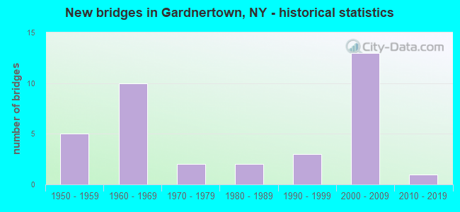
- New bridges - historical statistics
- 51950-1959
- 101960-1969
- 21970-1979
- 21980-1989
- 31990-1999
- 132000-2009
- 12010-2019

- Reconstructed bridges - Historical Statistics
- 11990-1999
- 12000-2009


- Bridge Condition - Deck
- 5.0%Excellent
- 35.0%Very good
- 10.0%Good
- 20.0%Satisfactory
- 25.0%Fair
- 5.0%Poor

- Bridge Condition - Superstructure
- 10.0%Excellent
- 30.0%Very good
- 20.0%Good
- 25.0%Satisfactory
- 15.0%Fair

- Bridge Condition - Substructure
- 30.0%Very good
- 30.0%Good
- 30.0%Satisfactory
- 5.0%Fair
- 5.0%Poor

- Bridge Condition - Channel
- 11.1%Good
- 44.4%Satisfactory
- 44.4%Fair

- Bridge Condition - Culverts
- 66.7%Satisfactory
- 33.3%Fair
Find on map >> Show street view
Structure Number: 102677, Location: 0.4 MI W JCT RTS 52+I84 (Lat: 41.518942, Lng: -74.052408), Route carried "on" structure: State highway 52, Year Built: 2016, Status: Open, Structure Length: 1.62m (5.31ft), Average Daily Traffic: 8,505 (year 2018), Truck Traffic: 3%, Average Future Daily Traffic: 10,331 (year 2040), Design Load: HL 93, Features Intersected: QUASSAIC CREEK
Minimum Vertical Clearance: 30+ m (98+ ft), Kilometerpoint: 25.599, Lanes on structure: 2, Base Highway Network: Yes, Owner: State Highway Agency, Approaching Roadway Width: 9.1m (29.9ft), Skew: 5 degrees, Material/Design: Concrete, Design/Construction: Box Beam or Girders - Multiple, Number Of Spans In Main Unit: 1, Length of Maximum Span: 14.0m (45.9ft), Curb or Sidewalk Widths: Left: 1.5m (4.9ft), Right: 0.0m, Curb-To-Curb Width: 10.4m (34.1ft), Out-to-Out Width: 13.4m (44.0ft)
Condition: Deck: Very good, Superstructure: Very good, Substructure: Very good, Channel: Good, Operating Rating: 53.5 metric tons, Method Used To Determine Operating Rating: Load Factor (LF), Inventory Rating: 31.8 metric tons, Method Used To Determine Inventory Rating: Load Factor (LF), Structural Evaluation: Better than present minimum criteria, Deck Geometry: Meets minimum limits, Waterway Adequacy: Meets minimum limits, Approach Roadway Alignment: Meets minimum limits, Length Of Structure Improvement: 1.61m (5.28ft), Designated Inspection Frequency: Every 24 months, Inspection Date: May 2021, Bridge Improvement Cost: $847,000, Roadway Improvement Cost: $496,000, Total Project Cost: $1,343,000 ( Estimate for 2021), Deck Structure Type: Concrete Cast-file-Place, Wearing Surface/Protective System: Wearing Surface: Integral Concrete, Deck Protection: Epoxy Coated Reinforcing
Find on map >> Show street view
Structure Number: 102678, Location: JCT RTS 52+I84 (Lat: 41.513717, Lng: -74.049561), Route carried "on" structure: State highway 52, Year Built: 1963, Status: Open, Structure Length: 6.86m (22.51ft), Average Daily Traffic: 8,505 (year 2018), Truck Traffic: 3%, Average Future Daily Traffic: 10,331 (year 2040), Design Load: HS 20+Mod, Features Intersected: 84I 84I83011374, RTE I84
Minimum Vertical Clearance: 30+ m (98+ ft), Kilometerpoint: 26.291, Lanes on structure: 3, Lanes under structure: 4, Base Highway Network: Yes, Owner: State Highway Agency, Approaching Roadway Width: 16.5m (54.1ft), Skew: 1 degrees, Material/Design: Steel, Design/Construction: Stringer/Multi-beam, Number Of Spans In Main Unit: 4, Length of Maximum Span: 20.1m (65.9ft), Curb-To-Curb Width: 15.8m (51.8ft), Out-to-Out Width: 17.4m (57.1ft)
Condition: Deck: Poor, Superstructure: Fair, Substructure: Fair, Operating Rating: 56.7 metric tons, Method Used To Determine Operating Rating: Load and Resistance Factor Rating (LRFR) rating reported by rating factor(RF) method using HL-93 loadings, Inventory Rating: 43.7 metric tons, Method Used To Determine Inventory Rating: Load and Resistance Factor Rating (LRFR) rating reported by rating factor(RF) method using HL-93 loadings, Structural Evaluation: Somewhat better than minimum adequacy, Deck Geometry: Better than present minimum criteria, Underclear: High priority of corrective action, Approach Roadway Alignment: Equal to present desirable criteria, Length Of Structure Improvement: 6.85m (22.47ft), Designated Inspection Frequency: Every 24 months, Inspection Date: November 2020, Bridge Improvement Cost: $4,438,000, Roadway Improvement Cost: $2,599,000, Total Project Cost: $7,036,000 ( Estimate for 2021), Deck Structure Type: Concrete Cast-file-Place, Wearing Surface/Protective System: Wearing Surface: Bituminous
Find on map >> Show street view
Structure Number: 1026791, Location: .2 MILE E OF EXIT 8 - I84 (Lat: 41.514669, Lng: -74.044553), Route carried "on" structure: Interstate 84, Year Built: 1963, Status: Open, Structure Length: 4.39m (14.40ft), Average Daily Traffic: 33,302 (year 2002), Truck Traffic: 15%, Design Load: HS 20+Mod, Features Intersected: TAFT AVENUE
Minimum Vertical Clearance: 30+ m (98+ ft), Kilometerpoint: 60.514, Lanes on structure: 2, Lanes under structure: 2, Base Highway Network: Yes, Owner: State Highway Agency, Approaching Roadway Width: 12.8m (42.0ft), Skew: 1 degrees, Material/Design: Steel, Design/Construction: Stringer/Multi-beam, Number Of Spans In Main Unit: 3, Length of Maximum Span: 14.6m (47.9ft), Curb or Sidewalk Widths: Left: 0.5m (1.6ft), Right: 0.5m (1.6ft), Curb-To-Curb Width: 11.6m (38.1ft), Out-to-Out Width: 13.2m (43.3ft)
Condition: Deck: Fair, Superstructure: Satisfactory, Substructure: Good, Operating Rating: 78.0 metric tons, Method Used To Determine Operating Rating: Load Factor (LF), Inventory Rating: 46.3 metric tons, Method Used To Determine Inventory Rating: Load Factor (LF), Structural Evaluation: Equal to present minimum criteria, Deck Geometry: Equal to present minimum criteria, Underclear: Meets minimum limits, Approach Roadway Alignment: Equal to present desirable criteria, Length Of Structure Improvement: 4.38m (14.37ft), Designated Inspection Frequency: Every 24 months, Inspection Date: June 2021, Bridge Improvement Cost: $2,279,000, Roadway Improvement Cost: $1,334,000, Total Project Cost: $3,613,000 ( Estimate for 2021), Deck Structure Type: Concrete Cast-file-Place, Wearing Surface/Protective System: Wearing Surface: Bituminous
Find on map >> Show street view
Structure Number: 1026792, Location: .2 MILE E OF EXIT 8 - I84 (Lat: 41.514425, Lng: -74.044528), Route carried "on" structure: Interstate 84, Year Built: 1963, Status: Open, Structure Length: 4.39m (14.40ft), Average Daily Traffic: 28,193 (year 2020), Truck Traffic: 16%, Average Future Daily Traffic: 47,741 (year 2040), Design Load: HS 20+Mod, Features Intersected: TAFT AVENUE
Minimum Vertical Clearance: 30+ m (98+ ft), Kilometerpoint: 60.611, Lanes on structure: 2, Lanes under structure: 2, Base Highway Network: Yes, Owner: State Highway Agency, Approaching Roadway Width: 12.8m (42.0ft), Skew: 1 degrees, Material/Design: Steel, Design/Construction: Stringer/Multi-beam, Number Of Spans In Main Unit: 3, Length of Maximum Span: 14.6m (47.9ft), Curb-To-Curb Width: 11.6m (38.1ft), Out-to-Out Width: 13.2m (43.3ft)
Condition: Deck: Fair, Superstructure: Satisfactory, Substructure: Good, Operating Rating: 78.0 metric tons, Method Used To Determine Operating Rating: Load Factor (LF), Inventory Rating: 46.3 metric tons, Method Used To Determine Inventory Rating: Load Factor (LF), Structural Evaluation: Equal to present minimum criteria, Deck Geometry: Equal to present minimum criteria, Underclear: Meets minimum limits, Approach Roadway Alignment: Equal to present desirable criteria, Length Of Structure Improvement: 4.38m (14.37ft), Designated Inspection Frequency: Every 24 months, Inspection Date: June 2021, Bridge Improvement Cost: $2,279,000, Roadway Improvement Cost: $1,334,000, Total Project Cost: $3,613,000 ( Estimate for 2021), Deck Structure Type: Concrete Cast-file-Place, Wearing Surface/Protective System: Wearing Surface: Bituminous
Find on map >> Show street view
Structure Number: 103246, Location: 0.4 MI E JCT I84&THRUWAY (Lat: 41.514486, Lng: -74.066822), Route carried "on" structure: State highway 300, Year Built: 1999, Status: Open, Structure Length: 5.88m (19.29ft), Average Daily Traffic: 15,760 (year 2019), Truck Traffic: 4%, Average Future Daily Traffic: 19,145 (year 2040), Design Load: HS 25 or greater, Features Intersected: 84I 84I83011346 WB, 84I
Minimum Vertical Clearance: 30+ m (98+ ft), Kilometerpoint: 12.647, Lanes on structure: 5, Lanes under structure: 6, Base Highway Network: Yes, Owner: State Highway Agency, Approaching Roadway Width: 22.9m (75.1ft), Skew: 1 degrees, Material/Design: Prestressed concrete continuous, Design/Construction: Box Beam or Girders - Multiple, Number Of Spans In Main Unit: 2, Length of Maximum Span: 29.0m (95.1ft), Curb-To-Curb Width: 22.8m (74.8ft), Out-to-Out Width: 23.8m (78.1ft)
Condition: Deck: Good, Superstructure: Very good, Substructure: Very good, Operating Rating: 88.9 metric tons, Method Used To Determine Operating Rating: Load Factor (LF), Inventory Rating: 51.7 metric tons, Method Used To Determine Inventory Rating: Load Factor (LF), Structural Evaluation: Equal to present desirable criteria, Deck Geometry: Equal to present minimum criteria, Underclear: High priority of corrective action, Approach Roadway Alignment: Equal to present desirable criteria, Length Of Structure Improvement: 5.88m (19.29ft), Designated Inspection Frequency: Every 24 months, Inspection Date: July 2021, Bridge Improvement Cost: $4,692,000, Roadway Improvement Cost: $2,748,000, Total Project Cost: $7,440,000 ( Estimate for 2021), Deck Structure Type: Concrete Cast-file-Place, Wearing Surface/Protective System: Wearing Surface: Monolithic Concrete, Deck Protection: Epoxy Coated Reinforcing
Find on map >> Show street view
Structure Number: 1032479, Location: .6 MI E JCT I84 & I87 (Lat: 41.513533, Lng: -74.055586), Route carried "on" structure: Interstate 84, Year Built: 1963, Status: Open, Structure Length: 1.13m (3.71ft), Average Daily Traffic: 60,086 (year 2019), Truck Traffic: 14%, Average Future Daily Traffic: 101,749 (year 2040), Design Load: HS 20+Mod, Features Intersected: QUASSAIC CREEK
Minimum Vertical Clearance: 30+ m (98+ ft), Kilometerpoint: 59.662, Lanes on structure: 4, Base Highway Network: Yes, Owner: State Highway Agency, Approaching Roadway Width: 24.4m (80.1ft), Skew: 21 degrees, Material/Design: Concrete continuous, Design/Construction: Culvert, Number Of Spans In Main Unit: 3, Length of Maximum Span: 3.3m (10.8ft)
Condition: Channel: Satisfactory, Culverts: Satisfactory, Structural Evaluation: Equal to present minimum criteria, Waterway Adequacy: Meets minimum limits, Approach Roadway Alignment: Equal to present desirable criteria, Length Of Structure Improvement: 1.12m (3.67ft), Designated Inspection Frequency: Every 24 months, Inspection Date: August 2021, Bridge Improvement Cost: $775,000, Roadway Improvement Cost: $454,000, Total Project Cost: $1,228,000 ( Estimate for 2021)
Find on map >> Show street view
Structure Number: 104527, Location: JCT NY 300 & I87 (Lat: 41.563331, Lng: -74.082772), Route carried "on" structure: State highway 300, Year Built: 2005, Status: Open, Structure Length: 7.47m (24.51ft), Average Daily Traffic: 5,526 (year 2020), Truck Traffic: 6%, Average Future Daily Traffic: 6,712 (year 2040), Design Load: HS 25 or greater, Features Intersected: 87IX SB, RTE I87
Minimum Vertical Clearance: 30+ m (98+ ft), Kilometerpoint: 6.098, Lanes on structure: 2, Lanes under structure: 4, Base Highway Network: Yes, Owner: State Toll Authority, Approaching Roadway Width: 11.6m (38.1ft), Skew: 5 degrees, Material/Design: Steel, Design/Construction: Stringer/Multi-beam, Number Of Spans In Main Unit: 2, Length of Maximum Span: 36.6m (120.1ft), Curb-To-Curb Width: 11.5m (37.7ft), Out-to-Out Width: 12.4m (40.7ft)
Condition: Deck: Very good, Superstructure: Very good, Substructure: Good, Structural Evaluation: Better than present minimum criteria, Deck Geometry: Meets minimum limits, Underclear: Somewhat better than minimum adequacy, Approach Roadway Alignment: Equal to present desirable criteria, Length Of Structure Improvement: 7.46m (24.48ft), Designated Inspection Frequency: Every 24 months, Inspection Date: October 2021, Bridge Improvement Cost: $5,461,000, Roadway Improvement Cost: $3,198,000, Total Project Cost: $8,659,000 ( Estimate for 2021), Deck Structure Type: Concrete Cast-file-Place, Wearing Surface/Protective System: Wearing Surface: Integral Concrete, Deck Protection: Galvanized Reinforcing
Find on map >> Show street view
Structure Number: 1052721, Location: JCT I84 & I87 (Lat: 41.514922, Lng: -74.073456), Route carried "on" structure: Interstate 84, Year Built: 1968, Year Reconstructed: 2006, Status: Open, Structure Length: 6.04m (19.82ft), Average Daily Traffic: 25,993 (year 2009), Truck Traffic: 20%, Design Load: HS 20, Features Intersected: 87IX NB, RTE I87
Minimum Vertical Clearance: 30+ m (98+ ft), Kilometerpoint: 58.053, Lanes on structure: 3, Lanes under structure: 4, Base Highway Network: Yes, Owner: State Highway Agency, Approaching Roadway Width: 15.8m (51.8ft), Material/Design: Steel, Design/Construction: Stringer/Multi-beam, Number Of Spans In Main Unit: 2, Length of Maximum Span: 31.3m (102.7ft), Curb-To-Curb Width: 16.0m (52.5ft), Out-to-Out Width: 16.9m (55.4ft)
Condition: Deck: Satisfactory, Superstructure: Good, Substructure: Satisfactory, Operating Rating: 93.4 metric tons, Method Used To Determine Operating Rating: Load Factor (LF), Inventory Rating: 56.2 metric tons, Method Used To Determine Inventory Rating: Load Factor (LF), Structural Evaluation: Equal to present minimum criteria, Deck Geometry: Equal to present minimum criteria, Underclear: High priority of corrective action, Approach Roadway Alignment: Equal to present desirable criteria, Length Of Structure Improvement: 6.03m (19.78ft), Designated Inspection Frequency: Every 24 months, Inspection Date: July 2021, Bridge Improvement Cost: $4,692,000, Roadway Improvement Cost: $2,748,000, Total Project Cost: $7,440,000 ( Estimate for 2021), Deck Structure Type: Concrete Cast-file-Place, Wearing Surface/Protective System: Wearing Surface: Monolithic Concrete
Find on map >> Show street view
Structure Number: 107858, Location: 1000' E JCT 84I & 87I (Lat: 41.514425, Lng: -74.069261), Route carried "on" structure: Interstate 84, Year Built: 2009, Status: Open, Structure Length: 10.73m (35.20ft), Average Daily Traffic: 46,873 (year 2009), Truck Traffic: 20%, Average Future Daily Traffic: 65,622 (year 2029), Design Load: HS 25 or greater, Features Intersected: 84I, Ramp WB-NS, 84I
Minimum Vertical Clearance: 99.00m (324.80ft), Kilometerpoint: 52.968, Lanes on structure: 1, Lanes under structure: 5, Base Highway Network: Yes, Owner: State Highway Agency, Approaching Roadway Width: 11.9m (39.0ft), Skew: 3 degrees, Material/Design: Steel continuous, Design/Construction: Stringer/Multi-beam, Number Of Spans In Main Unit: 3, Length of Maximum Span: 37.5m (123.0ft), Curb-To-Curb Width: 11.4m (37.4ft), Out-to-Out Width: 12.3m (40.4ft)
Condition: Deck: Very good, Superstructure: Excellent, Substructure: Very good, Operating Rating: 94.7 metric tons, Method Used To Determine Operating Rating: Field evaluation and documented engineering judgment, Inventory Rating: 40.8 metric tons, Method Used To Determine Inventory Rating: Field evaluation and documented engineering judgment, Structural Evaluation: Equal to present desirable criteria, Deck Geometry: Meets minimum limits, Underclear: High priority of corrective action, Approach Roadway Alignment: Equal to present desirable criteria, Length Of Structure Improvement: 10.72m (35.17ft), Designated Inspection Frequency: Every 24 months, Inspection Date: November 2021, Bridge Improvement Cost: $5,051,000, Roadway Improvement Cost: $2,958,000, Total Project Cost: $8,010,000 ( Estimate for 2021), Deck Structure Type: Concrete Cast-file-Place, Wearing Surface/Protective System: Wearing Surface: Integral Concrete, Deck Protection: Galvanized Reinforcing
Find on map >> Show street view
Structure Number: 107859, Location: 1400' E JCT 84I & 87I (Lat: 41.513381, Lng: -74.069056), Route carried "on" structure: Ramp Interstate , Year Built: 2009, Status: Open, Structure Length: 4.85m (15.91ft), Average Daily Traffic: 9,761 (year 2020), Truck Traffic: 15%, Average Future Daily Traffic: 16,529 (year 2040), Design Load: HS 25 or greater, Features Intersected: Ramp L-NS, ACCESS RD. B,, Facility Carried by Structure: Ramp NS
Minimum Vertical Clearance: 99.90m (327.76ft), Kilometerpoint: 0.032, Lanes on structure: 3, Lanes under structure: 5, Owner: State Toll Authority, Approaching Roadway Width: 17.1m (56.1ft), Skew: 22 degrees, Material/Design: Steel continuous, Design/Construction: Stringer/Multi-beam, Number Of Spans In Main Unit: 2, Length of Maximum Span: 26.2m (86.0ft), Curb-To-Curb Width: 20.0m (65.6ft), Out-to-Out Width: 20.9m (68.6ft)
Condition: Deck: Very good, Superstructure: Very good, Substructure: Good, Operating Rating: 63.5 metric tons, Method Used To Determine Operating Rating: Load Factor (LF), Inventory Rating: 38.1 metric tons, Method Used To Determine Inventory Rating: Load Factor (LF), Structural Evaluation: Better than present minimum criteria, Deck Geometry: Superior to present desirable criteria, Underclear: High priority of corrective action, Approach Roadway Alignment: Equal to present desirable criteria, Length Of Structure Improvement: 4.84m (15.88ft), Designated Inspection Frequency: Every 24 months, Inspection Date: October 2021, Bridge Improvement Cost: $4,084,000, Roadway Improvement Cost: $2,392,000, Total Project Cost: $6,475,000 ( Estimate for 2021), Deck Structure Type: Concrete Cast-file-Place, Wearing Surface/Protective System: Wearing Surface: Integral Concrete, Deck Protection: Galvanized Reinforcing
Find on map >> Show street view
Structure Number: 222328, Location: IN NEWBURGH (Lat: 41.539422, Lng: -74.041381), Route carried "on" structure: Other road , Year Built: 1987, Status: Open, Structure Length: 0.94m (3.08ft), Average Daily Traffic: 661 (year 2020), Truck Traffic: 6%, Average Future Daily Traffic: 925 (year 2040), Features Intersected: GIDNEYTOWN CREEK, Facility Carried by Structure: OLD PLANK ROAD
Minimum Vertical Clearance: 30+ m (98+ ft), Kilometerpoint: 0.306, Lanes on structure: 2, Owner: Town or Township Highway Agency, Approaching Roadway Width: 10.4m (34.1ft), Skew: 2 degrees, Material/Design: Prestressed concrete, Design/Construction: Box Beam or Girders - Multiple, Number Of Spans In Main Unit: 1, Length of Maximum Span: 9.1m (29.9ft), Curb-To-Curb Width: 10.4m (34.1ft), Out-to-Out Width: 11.7m (38.4ft)
Condition: Deck: Satisfactory, Superstructure: Satisfactory, Substructure: Satisfactory, Channel: Satisfactory, Operating Rating: 73.5 metric tons, Method Used To Determine Operating Rating: Load Factor (LF), Inventory Rating: 44.5 metric tons, Method Used To Determine Inventory Rating: Load Factor (LF), Structural Evaluation: Equal to present minimum criteria, Deck Geometry: Equal to present minimum criteria, Waterway Adequacy: Equal to present desirable criteria, Approach Roadway Alignment: Equal to present minimum criteria, Length Of Structure Improvement: 0.94m (3.08ft), Designated Inspection Frequency: Every 24 months, Inspection Date: April 2020, Bridge Improvement Cost: $375,000, Roadway Improvement Cost: $220,000, Total Project Cost: $595,000 ( Estimate for 2021), Wearing Surface/Protective System: Wearing Surface: Bituminous, Membrane: Other
Find on map >> Show street view
Structure Number: 222329, Location: .3 MI WSW INT RTS 52 & 84 (Lat: 41.512356, Lng: -74.055392), Route carried "on" structure: Other road , Year Built: 1987, Status: Open, Structure Length: 1.46m (4.79ft), Average Daily Traffic: 2,270 (year 2017), Truck Traffic: 4%, Average Future Daily Traffic: 3,178 (year 2037), Design Load: HS 20, Features Intersected: QUASSAIC CREEK, Facility Carried by Structure: BROOKSIDE FARM RD
Minimum Vertical Clearance: 30+ m (98+ ft), Kilometerpoint: 0.547, Lanes on structure: 2, Owner: Town or Township Highway Agency, Approaching Roadway Width: 6.1m (20.0ft), Material/Design: Prestressed concrete, Design/Construction: Box Beam or Girders - Multiple, Number Of Spans In Main Unit: 1, Length of Maximum Span: 14.3m (46.9ft), Curb-To-Curb Width: 8.0m (26.2ft), Out-to-Out Width: 8.6m (28.2ft)
Condition: Deck: Good, Superstructure: Satisfactory, Substructure: Good, Channel: Fair, Operating Rating: 82.7 metric tons, Method Used To Determine Operating Rating: Field evaluation and documented engineering judgment, Inventory Rating: 32.7 metric tons, Method Used To Determine Inventory Rating: Field evaluation and documented engineering judgment, Structural Evaluation: Equal to present minimum criteria, Deck Geometry: High priority of corrective action, Waterway Adequacy: Equal to present desirable criteria, Approach Roadway Alignment: Equal to present minimum criteria, Length Of Structure Improvement: 1.46m (4.79ft), Designated Inspection Frequency: Every 24 months, Inspection Date: Febuary 2020, Bridge Improvement Cost: $384,000, Roadway Improvement Cost: $225,000, Total Project Cost: $609,000 ( Estimate for 2021), Wearing Surface/Protective System: Wearing Surface: Bituminous, Membrane: Other
Find on map >> Show street view
Structure Number: 227024, Location: .33mi SE Int 300 & 52 on (Lat: 41.522892, Lng: -74.063017), Route carried "on" structure: Other road , Year Built: 1992, Status: Open, Structure Length: 0.85m (2.79ft), Truck Traffic: 2%, Features Intersected: BUSHFIELD CR, Facility Carried by Structure: INNIS AVE
Minimum Vertical Clearance: 30+ m (98+ ft), Kilometerpoint: 0.000, Lanes on structure: 2, Owner: Town or Township Highway Agency, Approaching Roadway Width: 7.3m (24.0ft), Skew: 1 degrees, Material/Design: Concrete, Design/Construction: Culvert, Number Of Spans In Main Unit: 2, Length of Maximum Span: 3.7m (12.1ft), Curb-To-Curb Width: 8.6m (28.2ft), Out-to-Out Width: 9.2m (30.2ft)
Condition: Channel: Fair, Culverts: Fair, Operating Rating: 74.8 metric tons, Method Used To Determine Operating Rating: Field evaluation and documented engineering judgment, Inventory Rating: 29.4 metric tons, Method Used To Determine Inventory Rating: Field evaluation and documented engineering judgment, Structural Evaluation: Somewhat better than minimum adequacy, Deck Geometry: Better than present minimum criteria, Waterway Adequacy: Meets minimum limits, Approach Roadway Alignment: Better than present minimum criteria, Length Of Structure Improvement: 0.85m (2.79ft), Designated Inspection Frequency: Every 24 months, Inspection Date: May 2021, Bridge Improvement Cost: $254,000, Roadway Improvement Cost: $149,000, Total Project Cost: $402,000 ( Estimate for 2021)
Find on map >> Show street view
Structure Number: 334501, Location: 3.5 MI NW OF NEWBURGH (Lat: 41.552069, Lng: -74.044061), Route carried "on" structure: County highway , Year Built: 1965, Status: Open, Structure Length: 1.16m (3.81ft), Average Daily Traffic: 3,526 (year 2020), Truck Traffic: 5%, Average Future Daily Traffic: 4,362 (year 2040), Design Load: H 20, Features Intersected: GIDNEYTOWN CREEK, Facility Carried by Structure: FOSTERTOWN RD
Minimum Vertical Clearance: 30+ m (98+ ft), Kilometerpoint: 3.379, Lanes on structure: 2, Owner: County Highway Agency, Approaching Roadway Width: 10.7m (35.1ft), Material/Design: Steel, Design/Construction: Stringer/Multi-beam, Number Of Spans In Main Unit: 1, Length of Maximum Span: 10.9m (35.8ft), Curb-To-Curb Width: 10.7m (35.1ft), Out-to-Out Width: 11.3m (37.1ft)
Condition: Deck: Satisfactory, Superstructure: Fair, Substructure: Satisfactory, Channel: Fair, Operating Rating: 55.3 metric tons, Method Used To Determine Operating Rating: Load Factor (LF), Inventory Rating: 32.7 metric tons, Method Used To Determine Inventory Rating: Load Factor (LF), Structural Evaluation: Somewhat better than minimum adequacy, Deck Geometry: Somewhat better than minimum adequacy, Waterway Adequacy: High priority of corrective action, Approach Roadway Alignment: Equal to present desirable criteria, Length Of Structure Improvement: 1.15m (3.77ft), Designated Inspection Frequency: Every 24 months, Inspection Date: August 2020, Bridge Improvement Cost: $873,000, Roadway Improvement Cost: $511,000, Total Project Cost: $1,384,000 ( Estimate for 2021), Deck Structure Type: Concrete Cast-file-Place, Wearing Surface/Protective System: Wearing Surface: Bituminous, Membrane: Other
Find on map >> Show street view
Structure Number: 336019, Location: 2.9 MI NW OF NEWBURGH (Lat: 41.530958, Lng: -74.062028), Route carried "on" structure: Other road , Year Built: 1973, Status: Open, Structure Length: 1.28m (4.20ft), Average Daily Traffic: 1,813 (year 2020), Truck Traffic: 4%, Average Future Daily Traffic: 2,243 (year 2040), Features Intersected: QUASSAIC CREEK, Facility Carried by Structure: GARDNERTOWN ROAD
Minimum Vertical Clearance: 30+ m (98+ ft), Kilometerpoint: 1.255, Lanes on structure: 2, Owner: County Highway Agency, Approaching Roadway Width: 8.8m (28.9ft), Material/Design: Steel, Design/Construction: Stringer/Multi-beam, Number Of Spans In Main Unit: 1, Length of Maximum Span: 10.9m (35.8ft), Curb-To-Curb Width: 8.8m (28.9ft), Out-to-Out Width: 9.5m (31.2ft)
Condition: Deck: Fair, Superstructure: Satisfactory, Substructure: Satisfactory, Channel: Satisfactory, Operating Rating: 39.9 metric tons, Method Used To Determine Operating Rating: Load and Resistance Factor Rating (LRFR) rating reported by rating factor(RF) method using HL-93 loadings, Inventory Rating: 30.8 metric tons, Method Used To Determine Inventory Rating: Load and Resistance Factor Rating (LRFR) rating reported by rating factor(RF) method using HL-93 loadings, Structural Evaluation: Equal to present minimum criteria, Deck Geometry: Somewhat better than minimum adequacy, Waterway Adequacy: Meets minimum limits, Approach Roadway Alignment: Equal to present desirable criteria, Length Of Structure Improvement: 1.28m (4.20ft), Designated Inspection Frequency: Every 24 months, Inspection Date: October 2020, Bridge Improvement Cost: $577,000, Roadway Improvement Cost: $338,000, Total Project Cost: $915,000 ( Estimate for 2021), Deck Structure Type: Concrete Cast-file-Place, Wearing Surface/Protective System: Wearing Surface: Bituminous
Find on map >> Show street view
Structure Number: 33602, Location: 2.4 MI NW OF NEWBURGH (Lat: 41.525419, Lng: -74.054983), Route carried "on" structure: Other road , Year Built: 1977, Status: Open, Structure Length: 1.68m (5.51ft), Average Daily Traffic: 3,230 (year 2020), Truck Traffic: 3%, Average Future Daily Traffic: 4,522 (year 2040), Design Load: HS 20, Features Intersected: QUASSAIC CREEK, Facility Carried by Structure: POWDER MILL ROAD
Minimum Vertical Clearance: 30+ m (98+ ft), Kilometerpoint: 0.740, Lanes on structure: 2, Owner: County Highway Agency, Approaching Roadway Width: 7.3m (24.0ft), Skew: 3 degrees, Material/Design: Steel, Design/Construction: Stringer/Multi-beam, Number Of Spans In Main Unit: 1, Length of Maximum Span: 14.6m (47.9ft), Curb-To-Curb Width: 10.1m (33.1ft), Out-to-Out Width: 10.7m (35.1ft)
Condition: Deck: Fair, Superstructure: Good, Substructure: Satisfactory, Channel: Satisfactory, Operating Rating: 43.4 metric tons, Method Used To Determine Operating Rating: Load and Resistance Factor Rating (LRFR) rating reported by rating factor(RF) method using HL-93 loadings, Inventory Rating: 33.4 metric tons, Method Used To Determine Inventory Rating: Load and Resistance Factor Rating (LRFR) rating reported by rating factor(RF) method using HL-93 loadings, Structural Evaluation: Equal to present minimum criteria, Deck Geometry: Meets minimum limits, Waterway Adequacy: Meets minimum limits, Approach Roadway Alignment: Equal to present desirable criteria, Length Of Structure Improvement: 1.67m (5.48ft), Designated Inspection Frequency: Every 24 months, Inspection Date: October 2020, Bridge Improvement Cost: $995,000, Roadway Improvement Cost: $583,000, Total Project Cost: $1,578,000 ( Estimate for 2021), Deck Structure Type: Concrete Cast-file-Place, Wearing Surface/Protective System: Wearing Surface: Bituminous, Membrane: Preformed Fabric
Find on map >> Show street view
Structure Number: 5026769, Location: JCT 87I & RTE 52 (Lat: 41.532022, Lng: -74.075675), Route carried "on" structure: Interstate 87, Year Built: 1954, Status: Open, Structure Length: 6.89m (22.60ft), Average Daily Traffic: 31,867 (year 2018), Truck Traffic: 18%, Average Future Daily Traffic: 53,963 (year 2040), Design Load: H 20, Features Intersected: RTE 52
Minimum Vertical Clearance: 30+ m (98+ ft), Kilometerpoint: 42.365, Lanes on structure: 4, Lanes under structure: 2, Base Highway Network: Yes, Toll: On Interstate toll segment, Owner: State Toll Authority, Approaching Roadway Width: 33.8m (110.9ft), Skew: 34 degrees, Material/Design: Steel continuous, Design/Construction: Stringer/Multi-beam, Number Of Spans In Main Unit: 3, Length of Maximum Span: 30.2m (99.1ft), Curb-To-Curb Width: 33.6m (110.2ft), Out-to-Out Width: 34.4m (112.9ft)
Condition: Deck: Fair, Superstructure: Good, Substructure: Satisfactory, Operating Rating: 18.1 metric tons, Method Used To Determine Operating Rating: Load and Resistance Factor Rating (LRFR) rating reported by rating factor(RF) method using HL-93 loadings, Inventory Rating: 13.0 metric tons, Method Used To Determine Inventory Rating: Load and Resistance Factor Rating (LRFR) rating reported by rating factor(RF) method using HL-93 loadings, Structural Evaluation: High priority of corrective action, Deck Geometry: Superior to present desirable criteria, Underclear: Meets minimum limits, Approach Roadway Alignment: Equal to present desirable criteria, Length Of Structure Improvement: 6.88m (22.57ft), Designated Inspection Frequency: Every 24 months, Inspection Date: July 2021, Bridge Improvement Cost: $9,179,000, Roadway Improvement Cost: $5,375,000, Total Project Cost: $14,554,000 ( Estimate for 2021), Deck Structure Type: Concrete Cast-file-Place, Wearing Surface/Protective System: Wearing Surface: Bituminous, Membrane: Other, Deck Protection: Epoxy Coated Reinforcing
Find on map >> Show street view
Structure Number: 551436, Location: 0.4 MI S JCT RT 300 & I84 (Lat: 41.508967, Lng: -74.067561), Route carried "on" structure: Ramp Other road , Year Built: 2000, Status: Open, Structure Length: 2.50m (8.20ft), Average Daily Traffic: 1,269 (year 2020), Truck Traffic: 15%, Average Future Daily Traffic: 2,148 (year 2040), Design Load: HS 25 or greater, Features Intersected: RTE 300, Facility Carried by Structure: EXIT 17 EZ PASS RA
Minimum Vertical Clearance: 30+ m (98+ ft), Kilometerpoint: 0.595, Lanes on structure: 1, Lanes under structure: 5, Owner: State Toll Authority, Approaching Roadway Width: 18.0m (59.1ft), Material/Design: Steel, Design/Construction: Stringer/Multi-beam, Number Of Spans In Main Unit: 1, Length of Maximum Span: 24.1m (79.1ft), Curb-To-Curb Width: 17.2m (56.4ft), Out-to-Out Width: 18.1m (59.4ft)
Condition: Deck: Excellent, Superstructure: Very good, Substructure: Very good, Operating Rating: 89.8 metric tons, Method Used To Determine Operating Rating: Load Factor (LF), Inventory Rating: 40.8 metric tons, Method Used To Determine Inventory Rating: Load Factor (LF), Structural Evaluation: Equal to present desirable criteria, Deck Geometry: Superior to present desirable criteria, Underclear: Meets minimum limits, Approach Roadway Alignment: Equal to present desirable criteria, Length Of Structure Improvement: 2.49m (8.17ft), Designated Inspection Frequency: Every 24 months, Inspection Date: May 2020, Bridge Improvement Cost: $3,794,000, Roadway Improvement Cost: $2,222,000, Total Project Cost: $6,016,000 ( Estimate for 2021), Deck Structure Type: Other, Wearing Surface/Protective System: Wearing Surface: Bituminous, Membrane: Other
Find on map >> Show street view
Structure Number: 551438, Location: 0.7 MI S JCT RTS I-87& 52 (Lat: 41.522186, Lng: -74.074497), Route carried "on" structure: Other road , Year Built: 1953, Year Reconstructed: 1998, Status: Open, Structure Length: 6.71m (22.01ft), Average Daily Traffic: 4,137 (year 2018), Truck Traffic: 3%, Average Future Daily Traffic: 5,118 (year 2040), Design Load: HS 20+Mod, Features Intersected: 87IX, RTE I87, Facility Carried by Structure: MEADOW HILL ROAD
Minimum Vertical Clearance: 30+ m (98+ ft), Kilometerpoint: 0.257, Lanes on structure: 2, Lanes under structure: 4, Owner: State Toll Authority, Approaching Roadway Width: 9.4m (30.8ft), Material/Design: Steel, Design/Construction: Stringer/Multi-beam, Number Of Spans In Main Unit: 4, Length of Maximum Span: 20.1m (65.9ft), Curb or Sidewalk Widths: Left: 0.8m (2.6ft), Right: 0.8m (2.6ft), Curb-To-Curb Width: 7.9m (25.9ft), Out-to-Out Width: 10.1m (33.1ft)
Condition: Deck: Satisfactory, Superstructure: Fair, Substructure: Poor, Operating Rating: 49.9 metric tons, Method Used To Determine Operating Rating: Load Factor (LF), Inventory Rating: 29.9 metric tons, Method Used To Determine Inventory Rating: Load Factor (LF), Structural Evaluation: Meets minimum limits, Deck Geometry: High priority of corrective action, Underclear: High priority of corrective action, Approach Roadway Alignment: Equal to present minimum criteria, Length Of Structure Improvement: 6.70m (21.98ft), Designated Inspection Frequency: Every 24 months, Inspection Date: September 2021, Bridge Improvement Cost: $2,568,000, Roadway Improvement Cost: $1,504,000, Total Project Cost: $4,072,000 ( Estimate for 2021), Deck Structure Type: Concrete Cast-file-Place, Wearing Surface/Protective System: Wearing Surface: Integral Concrete
Find on map >> Show street view
Structure Number: 551439, Location: .1 MI N JCT I87 & SH 52 (Lat: 41.532928, Lng: -74.076006), Route carried "on" structure: Interstate 87, Year Built: 1953, Status: Open, Structure Length: 0.94m (3.08ft), Average Daily Traffic: 31,867 (year 2018), Truck Traffic: 18%, Average Future Daily Traffic: 53,963 (year 2040), Design Load: HS 20+Mod, Features Intersected: ORANGE LAKE TRIBUTARY
Minimum Vertical Clearance: 30+ m (98+ ft), Kilometerpoint: 42.462, Lanes on structure: 4, Base Highway Network: Yes, Toll: On Interstate toll segment, Owner: State Toll Authority, Approaching Roadway Width: 33.2m (108.9ft), Skew: 33 degrees, Material/Design: Concrete, Design/Construction: Culvert, Number Of Spans In Main Unit: 2, Length of Maximum Span: 4.0m (13.1ft)
Condition: Channel: Fair, Culverts: Satisfactory, Structural Evaluation: Equal to present minimum criteria, Waterway Adequacy: Superior to present desirable criteria, Approach Roadway Alignment: Equal to present desirable criteria, Length Of Structure Improvement: 0.94m (3.08ft), Designated Inspection Frequency: Every 24 months, Inspection Date: May 2020, Bridge Improvement Cost: $1,543,000, Roadway Improvement Cost: $904,000, Total Project Cost: $2,447,000 ( Estimate for 2021), Wearing Surface/Protective System: Wearing Surface: Bituminous
Find on map >> Show street view
Structure Number: 55248, Location: 600' E JCT 84I & 87I (Lat: 41.514561, Lng: -74.071558), Route carried "on" structure: Ramp Other road , Year Built: 2009, Status: Open, Structure Length: 11.43m (37.50ft), Average Daily Traffic: 7,019 (year 2020), Truck Traffic: 15%, Average Future Daily Traffic: 11,885 (year 2040), Design Load: HS 25 or greater, Features Intersected: 84I X EB, 84I X, ACCESS, Facility Carried by Structure: Ramp WB-NS
Minimum Vertical Clearance: 30+ m (98+ ft), Kilometerpoint: 0.451, Lanes on structure: 1, Lanes under structure: 8, Owner: State Highway Agency, Approaching Roadway Width: 11.3m (37.1ft), Skew: 3 degrees, Material/Design: Steel continuous, Design/Construction: Stringer/Multi-beam, Number Of Spans In Main Unit: 3, Length of Maximum Span: 44.5m (146.0ft), Curb-To-Curb Width: 11.4m (37.4ft), Out-to-Out Width: 12.3m (40.4ft)
Condition: Deck: Very good, Superstructure: Excellent, Substructure: Very good, Operating Rating: 93.6 metric tons, Method Used To Determine Operating Rating: Field evaluation and documented engineering judgment, Inventory Rating: 40.8 metric tons, Method Used To Determine Inventory Rating: Field evaluation and documented engineering judgment, Structural Evaluation: Equal to present desirable criteria, Deck Geometry: Superior to present desirable criteria, Underclear: High priority of corrective action, Approach Roadway Alignment: Equal to present desirable criteria, Length Of Structure Improvement: 11.43m (37.50ft), Designated Inspection Frequency: Every 24 months, Inspection Date: November 2021, Bridge Improvement Cost: $5,340,000, Roadway Improvement Cost: $3,127,000, Total Project Cost: $8,466,000 ( Estimate for 2021), Deck Structure Type: Concrete Cast-file-Place, Wearing Surface/Protective System: Wearing Surface: Integral Concrete, Deck Protection: Galvanized Reinforcing
Find on map >> Show street view
Structure Number: 552482, Location: 500' W of Union Ave & I84 (Lat: 41.514383, Lng: -74.068594), Route carried "on" structure: Ramp State highway , Year Built: 2008, Status: Open, Structure Length: 6.71m (22.01ft), Truck Traffic: 15%, Design Load: HS 25 or greater, Features Intersected: 84IX WB, 84IX, Ramp WB-N, Facility Carried by Structure: Ramp 87I to Rt 300
Minimum Vertical Clearance: 30+ m (98+ ft), Kilometerpoint: 0.048, Lanes on structure: 2, Lanes under structure: 5, Toll: On Interstate toll segment, Owner: State Toll Authority, Approaching Roadway Width: 11.9m (39.0ft), Material/Design: Steel continuous, Design/Construction: Stringer/Multi-beam, Number Of Spans In Main Unit: 2, Length of Maximum Span: 37.8m (124.0ft), Curb-To-Curb Width: 12.0m (39.4ft), Out-to-Out Width: 12.9m (42.3ft)
Condition: Deck: Very good, Superstructure: Very good, Substructure: Very good, Inventory Rating: 65.3 metric tons, Method Used To Determine Inventory Rating: Load Factor (LF), Structural Evaluation: Equal to present desirable criteria, Deck Geometry: Superior to present desirable criteria, Underclear: High priority of corrective action, Approach Roadway Alignment: Equal to present desirable criteria, Length Of Structure Improvement: 6.70m (21.98ft), Designated Inspection Frequency: Every 24 months, Inspection Date: October 2021, Bridge Improvement Cost: $3,435,000, Roadway Improvement Cost: $2,012,000, Total Project Cost: $5,447,000 ( Estimate for 2021), Deck Structure Type: Concrete Cast-file-Place, Wearing Surface/Protective System: Wearing Surface: Integral Concrete, Deck Protection: Galvanized Reinforcing
Find on map >> Show street view
Structure Number: 552483, Location: 0.2 MI W RTE 300/I84 (Lat: 41.514275, Lng: -74.070825), Route carried "on" structure: Ramp Other road , Year Built: 2008, Status: Open, Structure Length: 6.83m (22.41ft), Average Daily Traffic: 3,366 (year 2020), Truck Traffic: 15%, Average Future Daily Traffic: 5,699 (year 2040), Design Load: HS 25 or greater, Features Intersected: ACCESS ROAD B, RAMP EB-L, Facility Carried by Structure: Ramp L-NS RTE 300
Minimum Vertical Clearance: 30+ m (98+ ft), Kilometerpoint: 0.338, Lanes on structure: 1, Lanes under structure: 3, Toll: On Interstate toll segment, Owner: State Toll Authority, Approaching Roadway Width: 10.7m (35.1ft), Skew: 3 degrees, Material/Design: Steel continuous, Design/Construction: Stringer/Multi-beam, Number Of Spans In Main Unit: 2, Length of Maximum Span: 33.2m (108.9ft), Curb-To-Curb Width: 10.7m (35.1ft), Out-to-Out Width: 11.6m (38.1ft)
Condition: Deck: Very good, Superstructure: Good, Substructure: Good, Inventory Rating: 58.1 metric tons, Method Used To Determine Inventory Rating: Load Factor (LF), Structural Evaluation: Better than present minimum criteria, Deck Geometry: Superior to present desirable criteria, Underclear: Meets minimum limits, Approach Roadway Alignment: Equal to present desirable criteria, Length Of Structure Improvement: 6.82m (22.38ft), Designated Inspection Frequency: Every 24 months, Inspection Date: June 2021, Bridge Improvement Cost: $3,286,000, Roadway Improvement Cost: $1,924,000, Total Project Cost: $5,211,000 ( Estimate for 2021), Deck Structure Type: Concrete Cast-file-Place, Wearing Surface/Protective System: Wearing Surface: Integral Concrete, Deck Protection: Galvanized Reinforcing
Find on map >> Show street view
Structure Number: 102678, Location: JCT RTS 52+I84 (Lat: 41.513717, Lng: -74.049561), Route carried "under" structure: Interstate 84, Year Built: 1963, Structure Length: 0. m, Average Daily Traffic: 19,000 (year 1971), Features Intersected: 84I 84I83011374, RTE I84, Facility Carried by Structure: RTE 52
Minimum Vertical Clearance: 5.13m (16.83ft), Kilometerpoint: 61.383, Lanes on structure: 3, Lanes under structure: 2, Material/Design: Steel, Design/Construction: Stringer/Multi-beam, Length of Maximum Span: 20.1m (65.9ft)
Find on map >> Show street view
Structure Number: 1026791, Location: .2 MILE E OF EXIT 8 - I84 (Lat: 41.514669, Lng: -74.044553), Route carried "under" structure: City street , Year Built: 1963, Structure Length: 0. m, Features Intersected: TAFT AVENUE, Facility Carried by Structure: RTE I84
Minimum Vertical Clearance: 4.95m (16.24ft), Kilometerpoint: 0.483, Lanes on structure: 2, Lanes under structure: 2, Material/Design: Steel, Design/Construction: Stringer/Multi-beam, Length of Maximum Span: 14.6m (47.9ft)
Find on map >> Show street view
Structure Number: 1026792, Location: .2 MILE E OF EXIT 8 - I84 (Lat: 41.514425, Lng: -74.044528), Route carried "under" structure: City street , Year Built: 1963, Structure Length: 0. m, Features Intersected: TAFT AVENUE, Facility Carried by Structure: RTE I84
Minimum Vertical Clearance: 4.90m (16.08ft), Kilometerpoint: 0.000, Lanes on structure: 2, Lanes under structure: 2, Toll: On toll road, Material/Design: Steel, Design/Construction: Stringer/Multi-beam, Length of Maximum Span: 14.6m (47.9ft)
Find on map >> Show street view
Structure Number: 103246, Location: 0.4 MI E JCT I84&THRUWAY (Lat: 41.514486, Lng: -74.066822), Route carried "under" structure: Interstate 84, Year Built: 1999, Structure Length: 0. m, Average Daily Traffic: 39,400 (year 1997), Features Intersected: 84I 84I83011346 WB, 84I, Facility Carried by Structure: RTE 300
Minimum Vertical Clearance: 5.30m (17.39ft), Kilometerpoint: 59.050, Lanes on structure: 5, Lanes under structure: 2, Material/Design: Prestressed concrete continuous, Design/Construction: Box Beam or Girders - Multiple, Length of Maximum Span: 29.0m (95.1ft)
Find on map >> Show street view
Structure Number: 104527, Location: JCT NY 300 & I87 (Lat: 41.563331, Lng: -74.082772), Route carried "under" structure: Interstate 87, Year Built: 2005, Structure Length: 0. m, Average Daily Traffic: 17,900 (year 1972), Features Intersected: 87IX SB, RTE I87, Facility Carried by Structure: RTE 300
Minimum Vertical Clearance: 6.10m (20.01ft), Kilometerpoint: 102.702, Lanes on structure: 2, Lanes under structure: 2, Toll: On Interstate toll segment, Material/Design: Steel, Design/Construction: Stringer/Multi-beam, Length of Maximum Span: 36.6m (120.1ft)
Find on map >> Show street view
Structure Number: 1052721, Location: JCT I84 & I87 (Lat: 41.514922, Lng: -74.073456), Route carried "under" structure: Interstate 87, Year Built: 1968, Structure Length: 0. m, Average Daily Traffic: 20,900 (year 1979), Features Intersected: 87IX NB, RTE I87, Facility Carried by Structure: RTE I84
Minimum Vertical Clearance: 6.35m (20.83ft), Kilometerpoint: 97.264, Lanes on structure: 3, Lanes under structure: 2, Toll: On toll road, Material/Design: Steel, Design/Construction: Stringer/Multi-beam, Length of Maximum Span: 31.3m (102.7ft)
Find on map >> Show street view
Structure Number: 107858, Location: 1000' E JCT 84I & 87I (Lat: 41.514425, Lng: -74.069261), Route carried "under" structure: Interstate , Year Built: 2009, Structure Length: 0. m, Features Intersected: 84I, Ramp WB-NS, 84I, Facility Carried by Structure: RTE 84
Minimum Vertical Clearance: 5.18m (16.99ft), Kilometerpoint: 58.246, Lanes on structure: 1, Lanes under structure: 1, Material/Design: Steel continuous, Design/Construction: Stringer/Multi-beam, Length of Maximum Span: 37.5m (123.0ft)
Find on map >> Show street view
Structure Number: 107859, Location: 1400' E JCT 84I & 87I (Lat: 41.513381, Lng: -74.069056), Route carried "under" structure: Ramp State highway , Year Built: 2009, Structure Length: 0. m, Features Intersected: Ramp L-NS, ACCESS RD. B,, Facility Carried by Structure: Ramp NS
Minimum Vertical Clearance: 5.23m (17.16ft), Kilometerpoint: 0.000, Lanes on structure: 3, Lanes under structure: 1, Material/Design: Steel continuous, Design/Construction: Stringer/Multi-beam, Length of Maximum Span: 26.2m (86.0ft)
Find on map >> Show street view
Structure Number: 5026769, Location: JCT 87I & RTE 52 (Lat: 41.532022, Lng: -74.075675), Route carried "under" structure: State highway 52, Year Built: 1954, Structure Length: 0. m, Average Daily Traffic: 11,975 (year 1999), Features Intersected: RTE 52, Facility Carried by Structure: RTE I87
Minimum Vertical Clearance: 4.98m (16.34ft), Kilometerpoint: 23.186, Lanes on structure: 4, Lanes under structure: 2, Material/Design: Steel continuous, Design/Construction: Stringer/Multi-beam, Length of Maximum Span: 30.2m (99.1ft)
Find on map >> Show street view
Structure Number: 551436, Location: 0.4 MI S JCT RT 300 & I84 (Lat: 41.508967, Lng: -74.067561), Route carried "under" structure: State highway 300, Year Built: 2000, Structure Length: 0. m, Average Daily Traffic: 27,060 (year 2014), Features Intersected: RTE 300, Facility Carried by Structure: EXIT 17 EZ PASS RA
Minimum Vertical Clearance: 5.05m (16.57ft), Kilometerpoint: 0.000, Lanes on structure: 1, Lanes under structure: 5, Material/Design: Steel, Design/Construction: Stringer/Multi-beam, Length of Maximum Span: 24.1m (79.1ft)
Find on map >> Show street view
Structure Number: 551438, Location: 0.7 MI S JCT RTS I-87& 52 (Lat: 41.522186, Lng: -74.074497), Route carried "under" structure: Interstate 87, Year Built: 1953, Structure Length: 0. m, Average Daily Traffic: 51,500 (year 2004), Features Intersected: 87IX, RTE I87, Facility Carried by Structure: MEADOW HILL ROAD
Minimum Vertical Clearance: 6.45m (21.16ft), Kilometerpoint: 98.069, Lanes on structure: 2, Lanes under structure: 2, Toll: On Interstate toll segment, Material/Design: Steel, Design/Construction: Stringer/Multi-beam, Length of Maximum Span: 20.1m (65.9ft)
Find on map >> Show street view
Structure Number: 55248, Location: 600' E JCT 84I & 87I (Lat: 41.514561, Lng: -74.071558), Route carried "under" structure: Interstate , Year Built: 2009, Structure Length: 0. m, Average Daily Traffic: 39,400 (year 1997), Features Intersected: 84I X EB, 84I X, ACCESS, Facility Carried by Structure: Ramp WB-NS
Minimum Vertical Clearance: 5.79m (19.00ft), Kilometerpoint: 58.729, Lanes on structure: 1, Lanes under structure: 1, Material/Design: Steel continuous, Design/Construction: Stringer/Multi-beam, Length of Maximum Span: 44.5m (146.0ft)
Find on map >> Show street view
Structure Number: 552482, Location: 500' W of Union Ave & I84 (Lat: 41.514383, Lng: -74.068594), Route carried "under" structure: Interstate , Year Built: 2008, Structure Length: 0. m, Features Intersected: 84IX WB, 84IX, Ramp WB-N, Facility Carried by Structure: Ramp 87I to Rt 300
Minimum Vertical Clearance: 7.44m (24.41ft), Kilometerpoint: 58.680, Lanes on structure: 2, Lanes under structure: 1, Material/Design: Steel continuous, Design/Construction: Stringer/Multi-beam, Length of Maximum Span: 37.8m (124.0ft)