Bridge Statistics for Garnett, Kansas (KS)
Condition, Traffic, Stress, Structural Evaluation, Project Costs
- National Bridge Inventory (NBI) Statistics
- 20Number of bridges
- 292ft / 89.5mTotal length
- $280,000Total costs
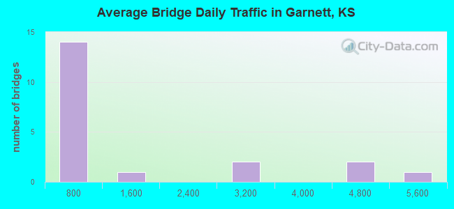
- 22,683Total average daily traffic
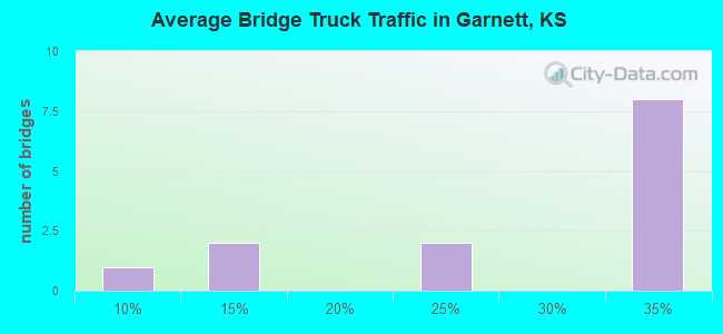
- 4,604Total average daily truck traffic
- National Bridge Inventory (NBI) Registered Bridges for Garnett
- No street view available for this location
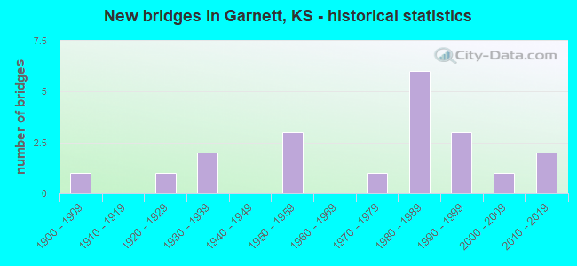
- New bridges - historical statistics
- 11900-1909
- 11920-1929
- 21930-1939
- 31950-1959
- 11970-1979
- 61980-1989
- 31990-1999
- 12000-2009
- 22010-2019
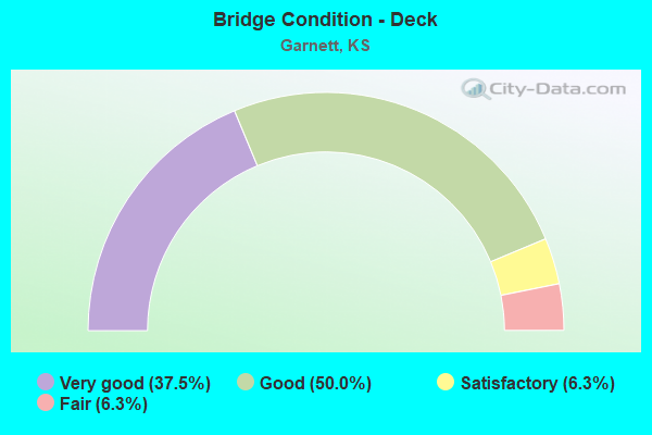
- Bridge Condition - Deck
- 37.5%Very good
- 50.0%Good
- 6.3%Satisfactory
- 6.3%Fair
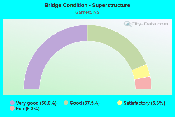
- Bridge Condition - Superstructure
- 50.0%Very good
- 37.5%Good
- 6.3%Satisfactory
- 6.3%Fair
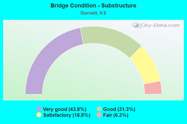
- Bridge Condition - Substructure
- 43.8%Very good
- 31.3%Good
- 18.8%Satisfactory
- 6.3%Fair
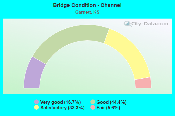
- Bridge Condition - Channel
- 16.7%Very good
- 44.4%Good
- 33.3%Satisfactory
- 5.6%Fair
Find on map >> Show street view
Structure Number: 20008, Location: 1.1 W OF 1650-MEADE (Lat: 38.262542, Lng: -95.305339), Route carried "on" structure: County highway 10, Year Built: 1954, Status: Posted for load, Structure Length: 6.72m (22.05ft), Average Daily Traffic: 840 (year 2014), Truck Traffic: 30%, Average Future Daily Traffic: 1,008 (year 2042), Design Load: H 15, Features Intersected: CEDAR CREEK, Facility Carried by Structure: 1650 RD L.4-16.3
Minimum Vertical Clearance: 30.47m (99.97ft), Kilometerpoint: 24.951, Lanes on structure: 2, Owner: County Highway Agency, Approaching Roadway Width: 7.0m (23.0ft), Material/Design: Concrete continuous, Design/Construction: Tee Beam, Number Of Spans In Main Unit: 3, Length of Maximum Span: 27.4m (89.9ft), Curb-To-Curb Width: 7.3m (24.0ft), Out-to-Out Width: 8.3m (27.2ft)
Condition: Deck: Satisfactory, Superstructure: Satisfactory, Substructure: Good, Channel: Good, Operating Rating: 40.2 metric tons, Method Used To Determine Operating Rating: Load Factor (LF), Inventory Rating: 23.6 metric tons, Method Used To Determine Inventory Rating: Load Factor (LF), Structural Evaluation: Equal to present minimum criteria, Deck Geometry: Meets minimum limits, Waterway Adequacy: Equal to present desirable criteria, Approach Roadway Alignment: Equal to present desirable criteria, Designated Inspection Frequency: Every 24 months, Inspection Date: January 2022, Deck Structure Type: Concrete Cast-file-Place, Wearing Surface/Protective System: Wearing Surface: Bituminous
Find on map >> Show street view
Structure Number: 20033, Location: 0.2 N OF OHIO-2200 (Lat: 38.349217, Lng: -95.203500), Route carried "on" structure: County highway 1390, Year Built: 1974, Status: Open, Structure Length: 10.58m (34.71ft), Average Daily Traffic: 76 (year 2014), Average Future Daily Traffic: 126 (year 2042), Design Load: HS 15, Features Intersected: POTTAWATOMIE CREEK, Facility Carried by Structure: Ohio R.0-22.2
Minimum Vertical Clearance: 30.47m (99.97ft), Kilometerpoint: 9.817, Lanes on structure: 2, Owner: County Highway Agency, Approaching Roadway Width: 6.7m (22.0ft), Material/Design: Concrete continuous, Design/Construction: Box Beam or Girders - Multiple, Number Of Spans In Main Unit: 5, Length of Maximum Span: 21.6m (70.9ft), Curb-To-Curb Width: 8.6m (28.2ft), Out-to-Out Width: 9.4m (30.8ft)
Condition: Deck: Good, Superstructure: Good, Substructure: Good, Channel: Good, Operating Rating: 63.9 metric tons, Method Used To Determine Operating Rating: Load Factor (LF), Inventory Rating: 37.2 metric tons, Method Used To Determine Inventory Rating: Load Factor (LF), Structural Evaluation: Better than present minimum criteria, Deck Geometry: Better than present minimum criteria, Waterway Adequacy: Equal to present desirable criteria, Approach Roadway Alignment: Equal to present desirable criteria, Designated Inspection Frequency: Every 24 months, Inspection Date: January 2022, Deck Structure Type: Concrete Cast-file-Place
Find on map >> Show street view
Structure Number: 2006, Location: 0.8 E OF 1750 - OSAGE (Lat: 38.280747, Lng: -95.180256), Route carried "on" structure: County highway 15, Year Built: 2012, Status: Open, Structure Length: 4.96m (16.27ft), Average Daily Traffic: 568 (year 2014), Truck Traffic: 30%, Average Future Daily Traffic: 682 (year 2042), Design Load: HL 93, Features Intersected: S Fork Pottawatomie Crk, Facility Carried by Structure: 1750 Rd. S.3-17.5
Minimum Vertical Clearance: 30.47m (99.97ft), Kilometerpoint: 0.000, Lanes on structure: 2, Owner: County Highway Agency, Approaching Roadway Width: 7.5m (24.6ft), Skew: 1 degrees, Material/Design: Concrete continuous, Design/Construction: Slab, Number Of Spans In Main Unit: 3, Length of Maximum Span: 19.5m (64.0ft), Curb-To-Curb Width: 9.1m (29.9ft), Out-to-Out Width: 9.8m (32.2ft)
Condition: Deck: Very good, Superstructure: Very good, Substructure: Very good, Channel: Good, Operating Rating: 33.4 metric tons, Method Used To Determine Operating Rating: Load and Resistance Factor (LRFR), Inventory Rating: 25.4 metric tons, Method Used To Determine Inventory Rating: Load and Resistance Factor (LRFR), Structural Evaluation: Equal to present minimum criteria, Deck Geometry: Equal to present minimum criteria, Waterway Adequacy: Equal to present desirable criteria, Approach Roadway Alignment: Equal to present desirable criteria, Designated Inspection Frequency: Every 24 months, Inspection Date: January 2022, Deck Structure Type: Concrete Cast-file-Place, Wearing Surface/Protective System: Wearing Surface: Monolithic Concrete
Find on map >> Show street view
Structure Number: 880004, Location: 6.0S.W. OF SATANTA (Lat: 37.361736, Lng: -101.050275), Route carried "on" structure: County highway 1562, Year Built: 1985, Status: Open, Structure Length: 0.87m (2.85ft), Average Daily Traffic: 85 (year 2008), Average Future Daily Traffic: 85 (year 2038), Design Load: H 20, Features Intersected: TRIB. TO CIMARRON RIVER
Minimum Vertical Clearance: 30.47m (99.97ft), Kilometerpoint: 0.000, Lanes on structure: 2, Owner: County Highway Agency, Approaching Roadway Width: 9.1m (29.9ft), Skew: 3 degrees, Material/Design: Concrete, Design/Construction: Culvert, Number Of Spans In Main Unit: 2, Length of Maximum Span: 4.3m (14.1ft), Curb-To-Curb Width: 9.1m (29.9ft), Out-to-Out Width: 9.8m (32.2ft)
Condition: Channel: Good, Culverts: Good, Operating Rating: 39.6 metric tons, Method Used To Determine Operating Rating: Load Factor (LF), Inventory Rating: 29.0 metric tons, Method Used To Determine Inventory Rating: Load Factor (LF), Structural Evaluation: Better than present minimum criteria, Deck Geometry: Better than present minimum criteria, Waterway Adequacy: Better than present minimum criteria, Approach Roadway Alignment: Equal to present desirable criteria, Designated Inspection Frequency: Every 24 months, Inspection Date: December 2020, Other Special Inspection Date: January 2001
Find on map >> Show street view
Structure Number: 21039605365, Location: 0.5 E 1750-MARSHALL (Lat: 38.282283, Lng: -95.293825), Route carried "on" structure: County highway , Year Built: 1908, Year Reconstructed: 1981, Status: Open, Structure Length: 4.52m (14.83ft), Average Daily Traffic: 25 (year 2014), Truck Traffic: 30%, Average Future Daily Traffic: 30 (year 2042), Design Load: H 20, Features Intersected: CEDAR CREEK, Facility Carried by Structure: 1750 Rd M.1-17.5
Minimum Vertical Clearance: 30.47m (99.97ft), Kilometerpoint: 0.000, Lanes on structure: 2, Owner: County Highway Agency, Approaching Roadway Width: 5.2m (17.1ft), Material/Design: Prestressed concrete, Design/Construction: Tee Beam, Number Of Spans In Main Unit: 3, Length of Maximum Span: 20.7m (67.9ft), Curb-To-Curb Width: 7.2m (23.6ft), Out-to-Out Width: 7.4m (24.3ft)
Condition: Deck: Good, Superstructure: Good, Substructure: Satisfactory, Channel: Satisfactory, Operating Rating: 47.7 metric tons, Method Used To Determine Operating Rating: Load Factor (LF), Inventory Rating: 27.2 metric tons, Method Used To Determine Inventory Rating: Load Factor (LF), Structural Evaluation: Equal to present minimum criteria, Deck Geometry: Somewhat better than minimum adequacy, Waterway Adequacy: Better than present minimum criteria, Approach Roadway Alignment: Meets minimum limits, Designated Inspection Frequency: Every 24 months, Inspection Date: January 2022, Deck Structure Type: Concrete Cast-file-Place
Find on map >> Show street view
Structure Number: 21041005281, Location: 3.0E 2.6N OF GLENLOCK (Lat: 38.345944, Lng: -95.285917), Route carried "on" structure: County highway , Year Built: 2004, Status: Open, Structure Length: 8.49m (27.85ft), Average Daily Traffic: 50 (year 2014), Truck Traffic: 30%, Average Future Daily Traffic: 60 (year 2042), Design Load: HL 93, Features Intersected: POTTAWATOMIE CREEK, Facility Carried by Structure: Meade M.5-21.9
Minimum Vertical Clearance: 30.47m (99.97ft), Kilometerpoint: 0.000, Lanes on structure: 2, Owner: County Highway Agency, Approaching Roadway Width: 5.2m (17.1ft), Skew: 3 degrees, Material/Design: Prestressed concrete continuous, Design/Construction: Stringer/Multi-beam, Number Of Spans In Main Unit: 3, Length of Maximum Span: 28.2m (92.5ft), Curb-To-Curb Width: 8.6m (28.2ft), Out-to-Out Width: 9.2m (30.2ft)
Condition: Deck: Very good, Superstructure: Very good, Substructure: Very good, Channel: Good, Operating Rating: 51.3 metric tons, Method Used To Determine Operating Rating: Load Factor (LF), Inventory Rating: 29.9 metric tons, Method Used To Determine Inventory Rating: Load Factor (LF), Structural Evaluation: Better than present minimum criteria, Deck Geometry: Better than present minimum criteria, Waterway Adequacy: Equal to present minimum criteria, Approach Roadway Alignment: Equal to present desirable criteria, Designated Inspection Frequency: Every 24 months, Inspection Date: January 2022, Deck Structure Type: Concrete Cast-file-Place
Find on map >> Show street view
Structure Number: 21041505321, Location: 1.0 N OF MISSOURI-1900 (Lat: 38.317944, Lng: -95.276892), Route carried "on" structure: County highway , Year Built: 1999, Status: Open, Structure Length: 5.05m (16.57ft), Average Daily Traffic: 20 (year 2014), Truck Traffic: 30%, Average Future Daily Traffic: 25 (year 2042), Design Load: HS 20, Features Intersected: CEDAR CREEK, Facility Carried by Structure: Missouri N.0-20.0
Minimum Vertical Clearance: 30.47m (99.97ft), Kilometerpoint: 0.000, Lanes on structure: 2, Owner: County Highway Agency, Approaching Roadway Width: 7.3m (24.0ft), Skew: 2 degrees, Material/Design: Concrete continuous, Design/Construction: Slab, Number Of Spans In Main Unit: 3, Length of Maximum Span: 20.1m (65.9ft), Curb-To-Curb Width: 7.9m (25.9ft), Out-to-Out Width: 8.5m (27.9ft)
Condition: Deck: Good, Superstructure: Good, Substructure: Very good, Channel: Good, Operating Rating: 62.1 metric tons, Method Used To Determine Operating Rating: Load Factor (LF), Inventory Rating: 36.3 metric tons, Method Used To Determine Inventory Rating: Load Factor (LF), Structural Evaluation: Better than present minimum criteria, Deck Geometry: Equal to present minimum criteria, Waterway Adequacy: Better than present minimum criteria, Approach Roadway Alignment: Equal to present minimum criteria, Designated Inspection Frequency: Every 24 months, Inspection Date: January 2022, Deck Structure Type: Concrete Cast-file-Place
Find on map >> Show street view
Structure Number: 21047005405, Location: 1.0 S OF NEBRASKA-HWY 169 (Lat: 38.250625, Lng: -95.239569), Route carried "on" structure: County highway , Year Built: 1988, Status: Open, Structure Length: 4.05m (13.29ft), Average Daily Traffic: 50 (year 2014), Average Future Daily Traffic: 60 (year 2042), Design Load: HS 20, Features Intersected: TRIB. S. FORK POTT. CK., Facility Carried by Structure: Nebraska P.0-15.6
Minimum Vertical Clearance: 30.47m (99.97ft), Kilometerpoint: 0.000, Lanes on structure: 2, Owner: County Highway Agency, Approaching Roadway Width: 5.4m (17.7ft), Material/Design: Concrete continuous, Design/Construction: Slab, Number Of Spans In Main Unit: 3, Length of Maximum Span: 14.9m (48.9ft), Curb-To-Curb Width: 7.3m (24.0ft), Out-to-Out Width: 7.9m (25.9ft)
Condition: Deck: Very good, Superstructure: Very good, Substructure: Very good, Channel: Satisfactory, Operating Rating: 59.4 metric tons, Method Used To Determine Operating Rating: Load Factor (LF), Inventory Rating: 34.5 metric tons, Method Used To Determine Inventory Rating: Load Factor (LF), Structural Evaluation: Equal to present desirable criteria, Deck Geometry: Equal to present minimum criteria, Waterway Adequacy: Better than present minimum criteria, Approach Roadway Alignment: Equal to present minimum criteria, Designated Inspection Frequency: Every 24 months, Inspection Date: January 2022, Deck Structure Type: Concrete Cast-file-Place
Find on map >> Show street view
Structure Number: 21047405288, Location: 0.2 N NEVADA-2100 (Lat: 38.334156, Lng: -95.223906), Route carried "on" structure: County highway , Year Built: 1920, Status: Posted for load, Structure Length: 0.85m (2.79ft), Average Daily Traffic: 20 (year 2014), Average Future Daily Traffic: 25 (year 2042), Features Intersected: TRIB. TO CEDAR CREEK, Facility Carried by Structure: Nevada P.8-21.2
Minimum Vertical Clearance: 30.47m (99.97ft), Kilometerpoint: 0.000, Lanes on structure: 2, Owner: County Highway Agency, Approaching Roadway Width: 5.4m (17.7ft), Material/Design: Masonry, Design/Construction: Arch - Deck, Number Of Spans In Main Unit: 1, Length of Maximum Span: 7.3m (24.0ft), Curb-To-Curb Width: 5.5m (18.0ft), Out-to-Out Width: 5.8m (19.0ft)
Condition: Deck: Fair, Superstructure: Fair, Substructure: Fair, Channel: Fair, Operating Rating: 21.6 metric tons, Method Used To Determine Operating Rating: No rating analysis performed, Inventory Rating: 15.4 metric tons, Method Used To Determine Inventory Rating: No rating analysis performed, Structural Evaluation: Meets minimum limits, Deck Geometry: Meets minimum limits, Waterway Adequacy: Somewhat better than minimum adequacy, Approach Roadway Alignment: Equal to present minimum criteria, Length Of Structure Improvement: 1.95m (6.40ft), Designated Inspection Frequency: Every 24 months, Inspection Date: January 2022, Bridge Improvement Cost: $170,000, Roadway Improvement Cost: $110,000, Total Project Cost: $280,000 ( Estimate for 2015), Wearing Surface/Protective System: Wearing Surface: Gravel
Find on map >> Show street view
Structure Number: 21047505403, Location: 1.3 S NEOSHO-HWY 169 (Lat: 38.255567, Lng: -95.231136), Route carried "on" structure: County highway , Year Built: 1950, Status: Posted for load, Structure Length: 1.65m (5.41ft), Average Daily Traffic: 20 (year 2014), Average Future Daily Traffic: 25 (year 2042), Features Intersected: TRIB. S. FK. POTT. CK., Facility Carried by Structure: Neosho P.5-15.7
Minimum Vertical Clearance: 30.47m (99.97ft), Kilometerpoint: 0.000, Lanes on structure: 2, Owner: County Highway Agency, Approaching Roadway Width: 5.4m (17.7ft), Material/Design: Steel, Design/Construction: Culvert, Number Of Spans In Main Unit: 2, Length of Maximum Span: 7.3m (24.0ft), Curb-To-Curb Width: 15.8m (51.8ft), Out-to-Out Width: 16.8m (55.1ft)
Condition: Channel: Satisfactory, Culverts: Good, Operating Rating: 10.3 metric tons, Method Used To Determine Operating Rating: Load Factor (LF), Inventory Rating: 6.2 metric tons, Method Used To Determine Inventory Rating: Load Factor (LF), Structural Evaluation: High priority of corrective action, Deck Geometry: Superior to present desirable criteria, Waterway Adequacy: Somewhat better than minimum adequacy, Approach Roadway Alignment: Equal to present desirable criteria, Bridge Posting: Required (Relationship of Operating Rating to Maximum Legal Load: > 39.9% below), Designated Inspection Frequency: Every 24 months, Inspection Date: January 2022
Find on map >> Show street view
Structure Number: 2105150538, Location: 0.5 E 1700-OSAGE (Lat: 38.273539, Lng: -95.184789), Route carried "on" structure: County highway , Year Built: 1987, Status: Open, Structure Length: 4.05m (13.29ft), Average Daily Traffic: 20 (year 2014), Truck Traffic: 30%, Average Future Daily Traffic: 30 (year 2042), Design Load: H 20, Features Intersected: S. FK. POTTAWATOMIE CK., Facility Carried by Structure: 1700 Rd R.9-17.0
Minimum Vertical Clearance: 30.47m (99.97ft), Kilometerpoint: 0.000, Lanes on structure: 2, Owner: County Highway Agency, Approaching Roadway Width: 5.7m (18.7ft), Material/Design: Concrete continuous, Design/Construction: Slab, Number Of Spans In Main Unit: 3, Length of Maximum Span: 14.9m (48.9ft), Curb-To-Curb Width: 7.3m (24.0ft), Out-to-Out Width: 7.9m (25.9ft)
Condition: Deck: Good, Superstructure: Good, Substructure: Very good, Channel: Good, Operating Rating: 41.4 metric tons, Method Used To Determine Operating Rating: Load Factor (LF), Inventory Rating: 24.5 metric tons, Method Used To Determine Inventory Rating: Load Factor (LF), Structural Evaluation: Equal to present minimum criteria, Deck Geometry: Equal to present minimum criteria, Waterway Adequacy: Equal to present minimum criteria, Approach Roadway Alignment: Meets minimum limits, Designated Inspection Frequency: Every 24 months, Inspection Date: January 2022, Deck Structure Type: Concrete Cast-file-Place
Find on map >> Show street view
Structure Number: 21053105347, Location: 1.0 E OF 1830-OSAGE (Lat: 38.291603, Lng: -95.174658), Route carried "on" structure: County highway , Year Built: 1995, Status: Open, Structure Length: 4.65m (15.26ft), Average Daily Traffic: 25 (year 2014), Average Future Daily Traffic: 30 (year 2042), Design Load: HS 20, Features Intersected: POTTAWATOMIE CREEK, Facility Carried by Structure: 1830 Rd S.5-18.3
Minimum Vertical Clearance: 30.47m (99.97ft), Kilometerpoint: 0.000, Lanes on structure: 2, Owner: County Highway Agency, Approaching Roadway Width: 6.0m (19.7ft), Skew: 1 degrees, Material/Design: Concrete continuous, Design/Construction: Slab, Number Of Spans In Main Unit: 3, Length of Maximum Span: 18.3m (60.0ft), Curb-To-Curb Width: 7.9m (25.9ft), Out-to-Out Width: 8.5m (27.9ft)
Condition: Deck: Good, Superstructure: Very good, Substructure: Satisfactory, Channel: Satisfactory, Operating Rating: 67.2 metric tons, Method Used To Determine Operating Rating: Load Factor (LF), Inventory Rating: 39.9 metric tons, Method Used To Determine Inventory Rating: Load Factor (LF), Structural Evaluation: Equal to present minimum criteria, Deck Geometry: Equal to present minimum criteria, Waterway Adequacy: Equal to present desirable criteria, Approach Roadway Alignment: Equal to present desirable criteria, Designated Inspection Frequency: Every 24 months, Inspection Date: January 2022, Deck Structure Type: Concrete Cast-file-Place
Find on map >> Show street view
Structure Number: 21053405346, Location: 1.5 E 1830-OSAGE (Lat: 38.293639, Lng: -95.166958), Route carried "on" structure: County highway , Year Built: 1995, Status: Open, Structure Length: 2.53m (8.30ft), Average Daily Traffic: 25 (year 2014), Average Future Daily Traffic: 30 (year 2042), Design Load: HS 20, Features Intersected: TRIB. POTTAWATOMIE CREEK, Facility Carried by Structure: 1830 Rd T.0-18.4
Minimum Vertical Clearance: 30.47m (99.97ft), Kilometerpoint: 0.000, Lanes on structure: 2, Owner: County Highway Agency, Approaching Roadway Width: 6.7m (22.0ft), Material/Design: Concrete continuous, Design/Construction: Slab, Number Of Spans In Main Unit: 3, Length of Maximum Span: 9.8m (32.2ft), Curb-To-Curb Width: 7.9m (25.9ft), Out-to-Out Width: 8.5m (27.9ft)
Condition: Deck: Very good, Superstructure: Very good, Substructure: Satisfactory, Channel: Satisfactory, Operating Rating: 54.9 metric tons, Method Used To Determine Operating Rating: Load Factor (LF), Inventory Rating: 31.8 metric tons, Method Used To Determine Inventory Rating: Load Factor (LF), Structural Evaluation: Equal to present minimum criteria, Deck Geometry: Equal to present minimum criteria, Waterway Adequacy: Better than present minimum criteria, Approach Roadway Alignment: Equal to present minimum criteria, Designated Inspection Frequency: Every 24 months, Inspection Date: January 2022, Deck Structure Type: Concrete Cast-file-Place
Find on map >> Show street view
Structure Number: 2105350532, Location: 0.5 E 2000-SCOTT (Lat: 38.317036, Lng: -95.166200), Route carried "on" structure: County highway 212, Year Built: 1981, Status: Open, Structure Length: 4.35m (14.27ft), Average Daily Traffic: 40 (year 2014), Truck Traffic: 30%, Average Future Daily Traffic: 50 (year 2042), Design Load: H 20, Features Intersected: SO. FK. POTTAWATOMIE CK., Facility Carried by Structure: 2000 Rd S.9-20.0
Minimum Vertical Clearance: 30.47m (99.97ft), Kilometerpoint: 0.000, Lanes on structure: 2, Owner: County Highway Agency, Approaching Roadway Width: 6.9m (22.6ft), Material/Design: Concrete continuous, Design/Construction: Slab, Number Of Spans In Main Unit: 3, Length of Maximum Span: 16.5m (54.1ft), Curb-To-Curb Width: 7.9m (25.9ft), Out-to-Out Width: 8.5m (27.9ft)
Condition: Deck: Good, Superstructure: Good, Substructure: Very good, Channel: Satisfactory, Operating Rating: 43.2 metric tons, Method Used To Determine Operating Rating: Load Factor (LF), Inventory Rating: 25.4 metric tons, Method Used To Determine Inventory Rating: Load Factor (LF), Structural Evaluation: Equal to present minimum criteria, Deck Geometry: Equal to present minimum criteria, Waterway Adequacy: Better than present minimum criteria, Approach Roadway Alignment: Equal to present desirable criteria, Designated Inspection Frequency: Every 24 months, Inspection Date: January 2022, Deck Structure Type: Concrete Cast-file-Place
Find on map >> Show street view
Structure Number: 999903100020341, Location: 18.14 MI SE COFFEY COLN (Lat: 38.298333, Lng: -95.287500), Route carried "on" structure: State highway 31, Year Built: 1987, Status: Open, Structure Length: 6.04m (19.82ft), Average Daily Traffic: 710 (year 2020), Truck Traffic: 7%, Average Future Daily Traffic: 956 (year 2041), Design Load: HS 20, Features Intersected: CEDAR CREEK
Minimum Vertical Clearance: 30.47m (99.97ft), Kilometerpoint: 28.736, Lanes on structure: 2, Owner: State Highway Agency, Approaching Roadway Width: 11.0m (36.1ft), Material/Design: Steel continuous, Design/Construction: Stringer/Multi-beam, Number Of Spans In Main Unit: 3, Length of Maximum Span: 22.9m (75.1ft), Curb-To-Curb Width: 11.0m (36.1ft), Out-to-Out Width: 11.6m (38.1ft)
Condition: Deck: Very good, Superstructure: Good, Substructure: Good, Channel: Very good, Operating Rating: 48.6 metric tons, Method Used To Determine Operating Rating: Load Factor (LF), Inventory Rating: 29.1 metric tons, Method Used To Determine Inventory Rating: Load Factor (LF), Structural Evaluation: Better than present minimum criteria, Deck Geometry: Better than present minimum criteria, Waterway Adequacy: Equal to present desirable criteria, Approach Roadway Alignment: Meets minimum limits, Length Of Structure Improvement: 19.80m (64.96ft), Designated Inspection Frequency: Every 24 months, Inspection Date: March 2020, Wearing Surface/Protective System: Wearing Surface: Monolithic Concrete, Deck Protection: Epoxy Coated Reinforcing
Find on map >> Show street view
Structure Number: 999905900020311, Location: 2.37 MI N-NJCT K31 (Lat: 38.322222, Lng: -95.250556), Route carried "on" structure: US 59, Year Built: 1957, Year Reconstructed: 1978, Status: Open, Structure Length: 2.85m (9.35ft), Average Daily Traffic: 4,436 (year 2020), Truck Traffic: 14%, Average Future Daily Traffic: 6,093 (year 2041), Design Load: HS 20, Features Intersected: ABANDONED ACCESS ROAD
Minimum Vertical Clearance: 30.47m (99.97ft), Kilometerpoint: 38.339, Lanes on structure: 2, Base Highway Network: Yes, Owner: State Highway Agency, Approaching Roadway Width: 12.8m (42.0ft), Material/Design: Prestressed concrete continuous, Design/Construction: Slab, Number Of Spans In Main Unit: 3, Length of Maximum Span: 10.7m (35.1ft), Curb-To-Curb Width: 9.8m (32.2ft), Out-to-Out Width: 10.1m (33.1ft)
Condition: Deck: Good, Superstructure: Very good, Substructure: Good, Channel: Good, Operating Rating: 37.2 metric tons, Method Used To Determine Operating Rating: Load Factor (LF), Inventory Rating: 26.3 metric tons, Method Used To Determine Inventory Rating: Load Factor (LF), Structural Evaluation: Equal to present minimum criteria, Deck Geometry: Meets minimum limits, Waterway Adequacy: Better than present minimum criteria, Approach Roadway Alignment: Equal to present minimum criteria, Length Of Structure Improvement: 9.36m (30.71ft), Designated Inspection Frequency: Every 24 months, Inspection Date: March 2020, Deck Structure Type: Concrete Cast-file-Place, Wearing Surface/Protective System: Wearing Surface: Monolithic Concrete
Find on map >> Show street view
Structure Number: 999905900020351, Location: 3.61 MI N SJCT US169 (Lat: 38.249444, Lng: -95.248333), Route carried "on" structure: US 59, Year Built: 1987, Status: Open, Structure Length: 4.95m (16.24ft), Average Daily Traffic: 4,855 (year 2020), Truck Traffic: 31%, Average Future Daily Traffic: 7,214 (year 2041), Design Load: HS 20, Features Intersected: SOUTH POTTAWATOMIE CREEK
Minimum Vertical Clearance: 30.47m (99.97ft), Kilometerpoint: 30.201, Lanes on structure: 2, Base Highway Network: Yes, Owner: State Highway Agency, Approaching Roadway Width: 8.5m (27.9ft), Material/Design: Steel continuous, Design/Construction: Stringer/Multi-beam, Number Of Spans In Main Unit: 3, Length of Maximum Span: 19.5m (64.0ft), Curb-To-Curb Width: 13.4m (44.0ft), Out-to-Out Width: 14.0m (45.9ft)
Condition: Deck: Good, Superstructure: Very good, Substructure: Good, Channel: Very good, Operating Rating: 67.1 metric tons, Method Used To Determine Operating Rating: Load Factor (LF), Inventory Rating: 40.8 metric tons, Method Used To Determine Inventory Rating: Load Factor (LF), Structural Evaluation: Better than present minimum criteria, Deck Geometry: Better than present minimum criteria, Waterway Adequacy: Equal to present desirable criteria, Approach Roadway Alignment: Somewhat better than minimum adequacy, Length Of Structure Improvement: 16.25m (53.31ft), Designated Inspection Frequency: Every 24 months, Inspection Date: March 2020, Wearing Surface/Protective System: Wearing Surface: Monolithic Concrete, Deck Protection: Epoxy Coated Reinforcing
Find on map >> Show street view
Structure Number: 999905900020421, Location: 3.17 MI N NJCT K31 (Lat: 38.333611, Lng: -95.248611), Route carried "on" structure: US 59, Year Built: 2016, Status: Open, Structure Length: 12.33m (40.45ft), Average Daily Traffic: 4,436 (year 2020), Truck Traffic: 14%, Average Future Daily Traffic: 6,093 (year 2041), Design Load: HL 93, Features Intersected: POTTAWATOMIE CREEK
Minimum Vertical Clearance: 30.47m (99.97ft), Kilometerpoint: 39.630, Lanes on structure: 2, Base Highway Network: Yes, Owner: State Highway Agency, Approaching Roadway Width: 12.8m (42.0ft), Skew: 1 degrees, Material/Design: Prestressed concrete continuous, Design/Construction: Stringer/Multi-beam, Number Of Spans In Main Unit: 4, Length of Maximum Span: 30.8m (101.0ft), Curb-To-Curb Width: 13.4m (44.0ft), Out-to-Out Width: 14.0m (45.9ft)
Condition: Deck: Very good, Superstructure: Very good, Substructure: Very good, Channel: Very good, Operating Rating: 66.1 metric tons, Method Used To Determine Operating Rating: Load and Resistance Factor Rating (LRFR) rating reported by rating factor(RF) method using HL-93 loadings, Inventory Rating: 43.7 metric tons, Method Used To Determine Inventory Rating: Load and Resistance Factor Rating (LRFR) rating reported by rating factor(RF) method using HL-93 loadings, Structural Evaluation: Equal to present desirable criteria, Deck Geometry: Better than present minimum criteria, Waterway Adequacy: Equal to present desirable criteria, Approach Roadway Alignment: Better than present minimum criteria, Length Of Structure Improvement: 40.46m (132.74ft), Designated Inspection Frequency: Every 24 months, Inspection Date: March 2020, Wearing Surface/Protective System: Wearing Surface: Monolithic Concrete, Deck Protection: Epoxy Coated Reinforcing
Find on map >> Show street view
Structure Number: 999905900020044, Location: 0.33 MI N NJCT US169 (Lat: 38.260833, Lng: -95.248889), Route carried "under" structure: US 59, Year Built: 1938, Structure Length: 0. m, Average Daily Traffic: 3,191 (year 2020), Truck Traffic: 21%, Features Intersected: US 59 HWY, Facility Carried by Structure: ATSF RAILROAD
Minimum Vertical Clearance: 4.34m (14.24ft), Kilometerpoint: 31.496, Lanes under structure: 2, Material/Design: Steel, Design/Construction: Girder and Floorbeam System, Length of Maximum Span: 21.8m (71.5ft)
Find on map >> Show street view
Structure Number: 999905900020054, Location: 1.24 MI N NJCT US169 (Lat: 38.273889, Lng: -95.249167), Route carried "under" structure: US 59, Year Built: 1939, Structure Length: 0. m, Average Daily Traffic: 3,191 (year 2020), Truck Traffic: 21%, Features Intersected: US 59 HWY, Facility Carried by Structure: UP RAILROAD
Minimum Vertical Clearance: 4.74m (15.55ft), Kilometerpoint: 32.961, Lanes under structure: 2, Material/Design: Steel, Design/Construction: Stringer/Multi-beam, Length of Maximum Span: 11.3m (37.1ft)