Bridge Statistics for Garrison, Montana (MT)
Condition, Traffic, Stress, Structural Evaluation, Project Costs
- National Bridge Inventory (NBI) Statistics
- 35Number of bridges
- 535ft / 163mTotal length
- $387,000Total costs
- 130,646Total average daily traffic
- 27,598Total average daily truck traffic
- National Bridge Inventory (NBI) Registered Bridges for Garrison
- No street view available for this location
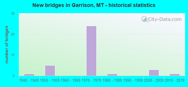
- New bridges - historical statistics
- 11940-1949
- 51950-1959
- 241970-1979
- 11980-1989
- 32000-2009
- 12010-2019

- Reconstructed bridges - Historical Statistics
- 31990-1999
- 12000-2009


- Bridge Condition - Deck
- 54.5%Good
- 45.5%Satisfactory

- Bridge Condition - Superstructure
- 4.5%Very good
- 54.5%Good
- 31.8%Satisfactory
- 9.1%Fair

- Bridge Condition - Substructure
- 31.8%Good
- 36.4%Satisfactory
- 22.7%Fair
- 9.1%Poor

- Bridge Condition - Channel
- 25.0%Very good
- 12.5%Good
- 50.0%Satisfactory
- 12.5%Fair
Find on map >> Show street view
Structure Number: I00090166+02721, Location: GOLD CREEK (Lat: 46.591964, Lng: -112.928264), Route carried "on" structure: Interstate 90, Year Built: 1959, Year Reconstructed: 2004, Status: Open, Structure Length: 4.72m (15.49ft), Average Daily Traffic: 7,940 (year 2020), Truck Traffic: 22%, Average Future Daily Traffic: 8,337 (year 2040), Design Load: HS 20, Features Intersected: INT GOLD CREEK
Minimum Vertical Clearance: 30+ m (98+ ft), Kilometerpoint: 265.979, Lanes on structure: 2, Lanes under structure: 2, Base Highway Network: Yes, Owner: State Highway Agency, Approaching Roadway Width: 12.0m (39.4ft), Material/Design: Prestressed concrete, Design/Construction: Stringer/Multi-beam, Number Of Spans In Main Unit: 3, Length of Maximum Span: 18.6m (61.0ft), Curb-To-Curb Width: 11.4m (37.4ft), Out-to-Out Width: 12.2m (40.0ft)
Condition: Deck: Satisfactory, Superstructure: Good, Substructure: Good, Operating Rating: 38.1 metric tons, Method Used To Determine Operating Rating: Assigned rating based on Load Factor Design (LFD) reported in metric tons, Inventory Rating: 32.7 metric tons, Method Used To Determine Inventory Rating: Assigned rating based on Load Factor Design (LFD) reported in metric tons, Structural Evaluation: Better than present minimum criteria, Deck Geometry: Somewhat better than minimum adequacy, Underclear: Meets minimum limits, Approach Roadway Alignment: Equal to present desirable criteria, Designated Inspection Frequency: Every 24 months, Inspection Date: June 2020, Deck Structure Type: Concrete Cast-file-Place, Wearing Surface/Protective System: Wearing Surface: Epoxy Overlay, Deck Protection: Epoxy Coated Reinforcing
Find on map >> Show street view
Structure Number: I00090166+02722, Location: GOLD CREEK (Lat: 46.592194, Lng: -112.928239), Route carried "on" structure: Interstate 90, Year Built: 1959, Year Reconstructed: 2004, Status: Open, Structure Length: 4.72m (15.49ft), Average Daily Traffic: 7,940 (year 2020), Truck Traffic: 22%, Average Future Daily Traffic: 8,337 (year 2040), Design Load: HS 20, Features Intersected: INT GOLD CREEK
Minimum Vertical Clearance: 30+ m (98+ ft), Kilometerpoint: 266.013, Lanes on structure: 2, Lanes under structure: 2, Base Highway Network: Yes, Owner: State Highway Agency, Approaching Roadway Width: 12.2m (40.0ft), Material/Design: Prestressed concrete, Design/Construction: Stringer/Multi-beam, Number Of Spans In Main Unit: 3, Length of Maximum Span: 18.6m (61.0ft), Curb-To-Curb Width: 11.4m (37.4ft), Out-to-Out Width: 12.2m (40.0ft)
Condition: Deck: Satisfactory, Superstructure: Satisfactory, Substructure: Good, Operating Rating: 39.0 metric tons, Method Used To Determine Operating Rating: Assigned rating based on Load Factor Design (LFD) reported in metric tons, Inventory Rating: 32.7 metric tons, Method Used To Determine Inventory Rating: Assigned rating based on Load Factor Design (LFD) reported in metric tons, Structural Evaluation: Equal to present minimum criteria, Deck Geometry: Somewhat better than minimum adequacy, Underclear: Meets minimum limits, Approach Roadway Alignment: Equal to present desirable criteria, Designated Inspection Frequency: Every 24 months, Inspection Date: June 2020, Deck Structure Type: Concrete Cast-file-Place, Wearing Surface/Protective System: Wearing Surface: Epoxy Overlay, Deck Protection: Epoxy Coated Reinforcing
Find on map >> Show street view
Structure Number: I00090170+00051, Location: 4.3M W GARRISON (Lat: 46.556733, Lng: -112.875328), Route carried "on" structure: Interstate 90, Year Built: 1973, Status: Open, Structure Length: 7.62m (25.00ft), Average Daily Traffic: 7,940 (year 2020), Truck Traffic: 22%, Average Future Daily Traffic: 8,337 (year 2040), Design Load: HS 20, Features Intersected: RR
Minimum Vertical Clearance: 30+ m (98+ ft), Kilometerpoint: 271.961, Lanes on structure: 2, Base Highway Network: Yes, Owner: State Highway Agency, Approaching Roadway Width: 11.6m (38.1ft), Skew: 4 degrees, Material/Design: Prestressed concrete, Design/Construction: Stringer/Multi-beam, Number Of Spans In Main Unit: 3, Length of Maximum Span: 26.5m (86.9ft), Curb-To-Curb Width: 12.7m (41.7ft), Out-to-Out Width: 13.7m (44.9ft)
Condition: Deck: Good, Superstructure: Good, Substructure: Poor, Operating Rating: 77.1 metric tons, Method Used To Determine Operating Rating: Load Factor (LF), Inventory Rating: 32.7 metric tons, Method Used To Determine Inventory Rating: Load Factor (LF), Structural Evaluation: Meets minimum limits, Deck Geometry: Better than present minimum criteria, Underclear: Better than present minimum criteria, Approach Roadway Alignment: Equal to present desirable criteria, Designated Inspection Frequency: Every 24 months, Inspection Date: October 2021, Deck Structure Type: Concrete Cast-file-Place, Wearing Surface/Protective System: Wearing Surface: Epoxy Overlay, Deck Protection: Epoxy Coated Reinforcing
Find on map >> Show street view
Structure Number: I00090170+00052, Location: 4.3M W GARRISON (Lat: 46.556931, Lng: -112.874906), Route carried "on" structure: Interstate 90, Year Built: 1973, Year Reconstructed: 2002, Status: Open, Structure Length: 8.07m (26.48ft), Average Daily Traffic: 7,940 (year 2020), Truck Traffic: 22%, Average Future Daily Traffic: 8,337 (year 2040), Design Load: HS 20, Features Intersected: RR
Minimum Vertical Clearance: 30+ m (98+ ft), Kilometerpoint: 272.025, Lanes on structure: 2, Base Highway Network: Yes, Owner: State Highway Agency, Approaching Roadway Width: 11.6m (38.1ft), Skew: 4 degrees, Material/Design: Prestressed concrete, Design/Construction: Stringer/Multi-beam, Number Of Spans In Main Unit: 3, Length of Maximum Span: 28.0m (91.9ft), Curb-To-Curb Width: 12.7m (41.7ft), Out-to-Out Width: 13.7m (44.9ft)
Condition: Deck: Good, Superstructure: Good, Substructure: Poor, Operating Rating: 77.1 metric tons, Method Used To Determine Operating Rating: Load Factor (LF), Inventory Rating: 32.7 metric tons, Method Used To Determine Inventory Rating: Load Factor (LF), Structural Evaluation: Meets minimum limits, Deck Geometry: Better than present minimum criteria, Underclear: Better than present minimum criteria, Approach Roadway Alignment: Equal to present desirable criteria, Designated Inspection Frequency: Every 24 months, Inspection Date: October 2021, Deck Structure Type: Concrete Cast-file-Place, Wearing Surface/Protective System: Wearing Surface: Epoxy Overlay, Deck Protection: Epoxy Coated Reinforcing
Find on map >> Show street view
Structure Number: I00090170+02411, Location: 3.7M W GARRISON (Lat: 46.556572, Lng: -112.870206), Route carried "on" structure: Interstate 90, Year Built: 1973, Status: Open, Structure Length: 3.90m (12.80ft), Average Daily Traffic: 8,741 (year 2020), Truck Traffic: 20%, Average Future Daily Traffic: 9,178 (year 2040), Design Load: HS 20, Features Intersected: INT PHOSPHATE
Minimum Vertical Clearance: 30+ m (98+ ft), Kilometerpoint: 272.354, Lanes on structure: 2, Lanes under structure: 2, Base Highway Network: Yes, Owner: State Highway Agency, Approaching Roadway Width: 13.7m (44.9ft), Skew: 2 degrees, Material/Design: Prestressed concrete, Design/Construction: Stringer/Multi-beam, Number Of Spans In Main Unit: 3, Length of Maximum Span: 14.0m (45.9ft), Curb-To-Curb Width: 12.7m (41.7ft), Out-to-Out Width: 13.7m (44.9ft)
Condition: Deck: Good, Superstructure: Good, Substructure: Fair, Operating Rating: 47.2 metric tons, Method Used To Determine Operating Rating: Load and Resistance Factor (LRFR), Inventory Rating: 29.0 metric tons, Method Used To Determine Inventory Rating: Load and Resistance Factor (LRFR), Structural Evaluation: Somewhat better than minimum adequacy, Deck Geometry: Better than present minimum criteria, Underclear: Meets minimum limits, Approach Roadway Alignment: Equal to present desirable criteria, Designated Inspection Frequency: Every 24 months, Inspection Date: October 2021, Deck Structure Type: Concrete Cast-file-Place, Wearing Surface/Protective System: Wearing Surface: Epoxy Overlay, Deck Protection: Epoxy Coated Reinforcing
Find on map >> Show street view
Structure Number: I00090170+02412, Location: 3.7M W GARRISON (Lat: 46.556781, Lng: -112.870117), Route carried "on" structure: Interstate 90, Year Built: 1973, Status: Open, Structure Length: 4.36m (14.30ft), Average Daily Traffic: 8,741 (year 2020), Truck Traffic: 20%, Average Future Daily Traffic: 9,178 (year 2040), Design Load: HS 20, Features Intersected: INT PHOSPHATE
Minimum Vertical Clearance: 30+ m (98+ ft), Kilometerpoint: 272.392, Lanes on structure: 2, Lanes under structure: 2, Base Highway Network: Yes, Owner: State Highway Agency, Approaching Roadway Width: 13.4m (44.0ft), Skew: 1 degrees, Material/Design: Prestressed concrete, Design/Construction: Stringer/Multi-beam, Number Of Spans In Main Unit: 3, Length of Maximum Span: 17.4m (57.1ft), Curb-To-Curb Width: 12.7m (41.7ft), Out-to-Out Width: 13.7m (44.9ft)
Condition: Deck: Good, Superstructure: Good, Substructure: Fair, Operating Rating: 47.2 metric tons, Method Used To Determine Operating Rating: Load and Resistance Factor (LRFR), Inventory Rating: 29.9 metric tons, Method Used To Determine Inventory Rating: Load and Resistance Factor (LRFR), Structural Evaluation: Somewhat better than minimum adequacy, Deck Geometry: Better than present minimum criteria, Underclear: Somewhat better than minimum adequacy, Approach Roadway Alignment: Equal to present desirable criteria, Designated Inspection Frequency: Every 24 months, Inspection Date: October 2021, Deck Structure Type: Concrete Cast-file-Place, Wearing Surface/Protective System: Wearing Surface: Epoxy Overlay
Find on map >> Show street view
Structure Number: I00090171+07791, Location: 2.5M W GARRISON (Lat: 46.542303, Lng: -112.846961), Route carried "on" structure: Interstate 90, Year Built: 1973, Status: Open, Structure Length: 2.38m (7.81ft), Average Daily Traffic: 8,741 (year 2020), Truck Traffic: 20%, Average Future Daily Traffic: 9,178 (year 2040), Design Load: HS 20, Features Intersected: SEP GARRISON FRONTAGE RD
Minimum Vertical Clearance: 30+ m (98+ ft), Kilometerpoint: 274.846, Lanes on structure: 2, Lanes under structure: 2, Base Highway Network: Yes, Owner: State Highway Agency, Approaching Roadway Width: 11.6m (38.1ft), Material/Design: Concrete continuous, Design/Construction: Slab, Number Of Spans In Main Unit: 3, Length of Maximum Span: 9.1m (29.9ft), Curb or Sidewalk Widths: Left: 0.1m (0.3ft), Right: 0.1m (0.3ft), Curb-To-Curb Width: 12.7m (41.7ft), Out-to-Out Width: 13.5m (44.3ft)
Condition: Deck: Satisfactory, Superstructure: Satisfactory, Substructure: Satisfactory, Operating Rating: 43.5 metric tons, Method Used To Determine Operating Rating: Load and Resistance Factor (LRFR), Inventory Rating: 33.6 metric tons, Method Used To Determine Inventory Rating: Load and Resistance Factor (LRFR), Structural Evaluation: Equal to present minimum criteria, Deck Geometry: Better than present minimum criteria, Underclear: High priority of corrective action, Approach Roadway Alignment: Better than present minimum criteria, Designated Inspection Frequency: Every 24 months, Inspection Date: August 2020, Deck Structure Type: Concrete Cast-file-Place
Find on map >> Show street view
Structure Number: I00090171+07792, Location: 2.5M W GARRISON (Lat: 46.542611, Lng: -112.846808), Route carried "on" structure: Interstate 90, Year Built: 1973, Status: Open, Structure Length: 2.38m (7.81ft), Average Daily Traffic: 8,741 (year 2020), Truck Traffic: 20%, Average Future Daily Traffic: 9,178 (year 2040), Design Load: HS 20, Features Intersected: SEP GARRISON FRONTAGE RD
Minimum Vertical Clearance: 30+ m (98+ ft), Kilometerpoint: 274.886, Lanes on structure: 2, Lanes under structure: 2, Base Highway Network: Yes, Owner: State Highway Agency, Approaching Roadway Width: 11.6m (38.1ft), Material/Design: Concrete continuous, Design/Construction: Slab, Number Of Spans In Main Unit: 3, Length of Maximum Span: 9.1m (29.9ft), Curb or Sidewalk Widths: Left: 0.1m (0.3ft), Right: 0.1m (0.3ft), Curb-To-Curb Width: 12.7m (41.7ft), Out-to-Out Width: 13.5m (44.3ft)
Condition: Deck: Satisfactory, Superstructure: Satisfactory, Substructure: Satisfactory, Operating Rating: 43.5 metric tons, Method Used To Determine Operating Rating: Load and Resistance Factor (LRFR), Inventory Rating: 33.6 metric tons, Method Used To Determine Inventory Rating: Load and Resistance Factor (LRFR), Structural Evaluation: Equal to present minimum criteria, Deck Geometry: Better than present minimum criteria, Underclear: High priority of corrective action, Approach Roadway Alignment: Better than present minimum criteria, Designated Inspection Frequency: Every 24 months, Inspection Date: August 2020, Deck Structure Type: Concrete Cast-file-Place
Find on map >> Show street view
Structure Number: I00090174+03631, Location: GARRISON (Lat: 46.522475, Lng: -112.809636), Route carried "on" structure: Interstate 90, Year Built: 1979, Status: Open, Structure Length: 21.63m (70.96ft), Average Daily Traffic: 7,487 (year 2020), Truck Traffic: 24%, Average Future Daily Traffic: 7,861 (year 2040), Design Load: HS 20, Features Intersected: INT W GARRISON-RR
Minimum Vertical Clearance: 30+ m (98+ ft), Kilometerpoint: 279.048, Lanes on structure: 2, Lanes under structure: 8, Base Highway Network: Yes, Owner: State Highway Agency, Approaching Roadway Width: 12.8m (42.0ft), Material/Design: Prestressed concrete, Design/Construction: Stringer/Multi-beam, Number Of Spans In Main Unit: 7, Length of Maximum Span: 32.6m (107.0ft), Curb-To-Curb Width: 12.7m (41.7ft), Out-to-Out Width: 13.6m (44.6ft)
Condition: Deck: Satisfactory, Superstructure: Fair, Substructure: Fair, Operating Rating: 52.6 metric tons, Method Used To Determine Operating Rating: Load and Resistance Factor (LRFR), Inventory Rating: 33.6 metric tons, Method Used To Determine Inventory Rating: Load and Resistance Factor (LRFR), Structural Evaluation: Somewhat better than minimum adequacy, Deck Geometry: Better than present minimum criteria, Underclear: Somewhat better than minimum adequacy, Approach Roadway Alignment: Equal to present desirable criteria, Designated Inspection Frequency: Every 24 months, Inspection Date: July 2021, Deck Structure Type: Concrete Cast-file-Place, Wearing Surface/Protective System: Wearing Surface: Latex Concrete
Find on map >> Show street view
Structure Number: I00090174+03632, Location: GARRISON (Lat: 46.522581, Lng: -112.809111), Route carried "on" structure: Interstate 90, Year Built: 1979, Status: Open, Structure Length: 21.63m (70.96ft), Average Daily Traffic: 7,487 (year 2020), Truck Traffic: 24%, Average Future Daily Traffic: 7,861 (year 2040), Design Load: HS 20, Features Intersected: INT W GARRISISON-RR
Minimum Vertical Clearance: 30+ m (98+ ft), Kilometerpoint: 279.123, Lanes on structure: 2, Lanes under structure: 4, Base Highway Network: Yes, Owner: State Highway Agency, Approaching Roadway Width: 11.6m (38.1ft), Material/Design: Prestressed concrete, Design/Construction: Stringer/Multi-beam, Number Of Spans In Main Unit: 7, Length of Maximum Span: 32.6m (107.0ft), Curb-To-Curb Width: 12.7m (41.7ft), Out-to-Out Width: 13.6m (44.6ft)
Condition: Deck: Satisfactory, Superstructure: Satisfactory, Substructure: Fair, Operating Rating: 45.4 metric tons, Method Used To Determine Operating Rating: Load and Resistance Factor (LRFR), Inventory Rating: 18.1 metric tons, Method Used To Determine Inventory Rating: Load and Resistance Factor (LRFR), Structural Evaluation: Meets minimum limits, Deck Geometry: Better than present minimum criteria, Underclear: High priority of corrective action, Approach Roadway Alignment: Equal to present desirable criteria, Designated Inspection Frequency: Every 24 months, Inspection Date: July 2021, Deck Structure Type: Concrete Cast-file-Place, Wearing Surface/Protective System: Wearing Surface: Latex Concrete
Find on map >> Show street view
Structure Number: I00090175+02151, Location: 1.2M S GARRISON (Lat: 46.515481, Lng: -112.795786), Route carried "on" structure: Interstate 90, Year Built: 1979, Status: Open, Structure Length: 4.04m (13.25ft), Average Daily Traffic: 7,487 (year 2020), Truck Traffic: 24%, Average Future Daily Traffic: 7,861 (year 2040), Design Load: HS 20, Features Intersected: LITTLE BLACKFOOT RIVER
Minimum Vertical Clearance: 30+ m (98+ ft), Kilometerpoint: 280.369, Lanes on structure: 2, Base Highway Network: Yes, Owner: State Highway Agency, Approaching Roadway Width: 12.8m (42.0ft), Material/Design: Prestressed concrete, Design/Construction: Stringer/Multi-beam, Number Of Spans In Main Unit: 2, Length of Maximum Span: 19.8m (65.0ft), Curb or Sidewalk Widths: Left: 0.1m (0.3ft), Right: 0.1m (0.3ft), Curb-To-Curb Width: 12.5m (41.0ft), Out-to-Out Width: 13.5m (44.3ft)
Condition: Deck: Good, Superstructure: Very good, Substructure: Good, Channel: Very good, Operating Rating: 58.0 metric tons, Method Used To Determine Operating Rating: Assigned rating based on Load Factor Design (LFD) reported in metric tons, Inventory Rating: 32.7 metric tons, Method Used To Determine Inventory Rating: Assigned rating based on Load Factor Design (LFD) reported in metric tons, Structural Evaluation: Better than present minimum criteria, Deck Geometry: Better than present minimum criteria, Waterway Adequacy: Equal to present desirable criteria, Approach Roadway Alignment: Equal to present desirable criteria, Designated Inspection Frequency: Every 48 months, Inspection Date: January 2022, Deck Structure Type: Concrete Cast-file-Place, Wearing Surface/Protective System: Wearing Surface: Monolithic Concrete
Find on map >> Show street view
Structure Number: I00090175+02152, Location: 1.2M S GARRISON (Lat: 46.515697, Lng: -112.795500), Route carried "on" structure: Interstate 90, Year Built: 1979, Status: Open, Structure Length: 3.99m (13.09ft), Average Daily Traffic: 7,487 (year 2020), Truck Traffic: 24%, Average Future Daily Traffic: 7,861 (year 2040), Design Load: HS 20, Features Intersected: LITTLE BLACKFOOT RIVER
Minimum Vertical Clearance: 30+ m (98+ ft), Kilometerpoint: 280.421, Lanes on structure: 2, Base Highway Network: Yes, Owner: State Highway Agency, Approaching Roadway Width: 12.8m (42.0ft), Material/Design: Prestressed concrete, Design/Construction: Stringer/Multi-beam, Number Of Spans In Main Unit: 2, Length of Maximum Span: 19.8m (65.0ft), Curb or Sidewalk Widths: Left: 0.1m (0.3ft), Right: 0.1m (0.3ft), Curb-To-Curb Width: 12.7m (41.7ft), Out-to-Out Width: 13.5m (44.3ft)
Condition: Deck: Good, Superstructure: Good, Substructure: Good, Channel: Very good, Operating Rating: 58.0 metric tons, Method Used To Determine Operating Rating: Assigned rating based on Load Factor Design (LFD) reported in metric tons, Inventory Rating: 32.7 metric tons, Method Used To Determine Inventory Rating: Assigned rating based on Load Factor Design (LFD) reported in metric tons, Structural Evaluation: Better than present minimum criteria, Deck Geometry: Better than present minimum criteria, Waterway Adequacy: Equal to present desirable criteria, Approach Roadway Alignment: Equal to present desirable criteria, Designated Inspection Frequency: Every 48 months, Inspection Date: January 2022, Deck Structure Type: Concrete Cast-file-Place, Wearing Surface/Protective System: Wearing Surface: Monolithic Concrete
Find on map >> Show street view
Structure Number: I00090175+05331, Location: 1.2M S GARRISON (Lat: 46.513633, Lng: -112.789697), Route carried "on" structure: Interstate 90, Year Built: 1979, Status: Open, Structure Length: 18.22m (59.78ft), Average Daily Traffic: 7,487 (year 2020), Truck Traffic: 24%, Average Future Daily Traffic: 7,861 (year 2040), Design Load: HS 20, Features Intersected: INT E GARRISON-RR
Minimum Vertical Clearance: 30+ m (98+ ft), Kilometerpoint: 280.888, Lanes on structure: 2, Lanes under structure: 2, Base Highway Network: Yes, Owner: State Highway Agency, Approaching Roadway Width: 12.8m (42.0ft), Material/Design: Steel continuous, Design/Construction: Stringer/Multi-beam, Number Of Spans In Main Unit: 5, Length of Maximum Span: 45.1m (148.0ft), Curb-To-Curb Width: 12.6m (41.3ft), Out-to-Out Width: 13.5m (44.3ft)
Condition: Deck: Satisfactory, Superstructure: Good, Substructure: Satisfactory, Operating Rating: 61.7 metric tons, Method Used To Determine Operating Rating: Load Factor (LF), Inventory Rating: 36.3 metric tons, Method Used To Determine Inventory Rating: Load Factor (LF), Structural Evaluation: Equal to present minimum criteria, Deck Geometry: Better than present minimum criteria, Underclear: High priority of corrective action, Approach Roadway Alignment: Equal to present desirable criteria, Designated Inspection Frequency: Every 24 months, Inspection Date: September 2020, Deck Structure Type: Concrete Cast-file-Place, Wearing Surface/Protective System: Wearing Surface: Epoxy Overlay
Find on map >> Show street view
Structure Number: I00090175+05332, Location: 1.2M S GARRISON (Lat: 46.513978, Lng: -112.790003), Route carried "on" structure: Interstate 90, Year Built: 1979, Status: Open, Structure Length: 17.73m (58.17ft), Average Daily Traffic: 7,487 (year 2020), Truck Traffic: 24%, Average Future Daily Traffic: 7,861 (year 2040), Design Load: HS 20, Features Intersected: INT E GARRISON-RR
Minimum Vertical Clearance: 30+ m (98+ ft), Kilometerpoint: 280.891, Lanes on structure: 2, Lanes under structure: 2, Base Highway Network: Yes, Owner: State Highway Agency, Approaching Roadway Width: 12.8m (42.0ft), Material/Design: Steel continuous, Design/Construction: Stringer/Multi-beam, Number Of Spans In Main Unit: 5, Length of Maximum Span: 45.1m (148.0ft), Curb-To-Curb Width: 12.6m (41.3ft), Out-to-Out Width: 13.4m (44.0ft)
Condition: Deck: Satisfactory, Superstructure: Satisfactory, Substructure: Satisfactory, Operating Rating: 61.7 metric tons, Method Used To Determine Operating Rating: Load Factor (LF), Inventory Rating: 37.2 metric tons, Method Used To Determine Inventory Rating: Load Factor (LF), Structural Evaluation: Equal to present minimum criteria, Deck Geometry: Better than present minimum criteria, Underclear: High priority of corrective action, Approach Roadway Alignment: Equal to present desirable criteria, Designated Inspection Frequency: Every 24 months, Inspection Date: September 2020, Deck Structure Type: Concrete Cast-file-Place, Wearing Surface/Protective System: Wearing Surface: Epoxy Overlay
Find on map >> Show street view
Structure Number: L39017001+07001, Location: 5M NW DEER LODGE (Lat: 46.466797, Lng: -112.865125), Route carried "on" structure: County highway 17, Year Built: 2007, Status: Open, Structure Length: 1.52m (4.99ft), Average Daily Traffic: 100 (year 2022), Truck Traffic: 3%, Average Future Daily Traffic: 100 (year 2037), Design Load: HS 20, Features Intersected: ROCK CREEK 078, Facility Carried by Structure: N OLD STAGE RD
Minimum Vertical Clearance: 30+ m (98+ ft), Kilometerpoint: 11.677, Lanes on structure: 2, Owner: County Highway Agency, Approaching Roadway Width: 8.5m (27.9ft), Material/Design: Prestressed concrete, Design/Construction: Tee Beam, Number Of Spans In Main Unit: 1, Length of Maximum Span: 14.9m (48.9ft), Curb-To-Curb Width: 7.3m (24.0ft), Out-to-Out Width: 7.9m (25.9ft)
Condition: Deck: Good, Superstructure: Good, Substructure: Good, Channel: Satisfactory, Operating Rating: 67.5 metric tons, Method Used To Determine Operating Rating: Load Factor (LF), Inventory Rating: 40.4 metric tons, Method Used To Determine Inventory Rating: Load Factor (LF), Structural Evaluation: Better than present minimum criteria, Deck Geometry: Equal to present minimum criteria, Waterway Adequacy: Equal to present desirable criteria, Approach Roadway Alignment: Equal to present minimum criteria, Designated Inspection Frequency: Every 24 months, Inspection Date: July 2021, Deck Structure Type: Other
Find on map >> Show street view
Structure Number: L39027000+04001, Location: GARRISON (Lat: 46.519703, Lng: -112.807983), Route carried "on" structure: County highway 39015, Year Built: 2006, Status: Open, Structure Length: 5.13m (16.83ft), Average Daily Traffic: 100 (year 2022), Truck Traffic: 3%, Average Future Daily Traffic: 100 (year 2037), Design Load: HS 20+Mod, Features Intersected: CLARK FORK RIVER 026, Facility Carried by Structure: SAWMILL RD
Minimum Vertical Clearance: 30+ m (98+ ft), Kilometerpoint: 0.386, Lanes on structure: 2, Owner: County Highway Agency, Approaching Roadway Width: 8.4m (27.6ft), Material/Design: Prestressed concrete, Design/Construction: Stringer/Multi-beam, Number Of Spans In Main Unit: 2, Length of Maximum Span: 25.2m (82.7ft), Curb-To-Curb Width: 8.4m (27.6ft), Out-to-Out Width: 9.1m (29.9ft)
Condition: Deck: Satisfactory, Superstructure: Good, Substructure: Satisfactory, Channel: Satisfactory, Operating Rating: 57.8 metric tons, Method Used To Determine Operating Rating: Load and Resistance Factor (LRFR), Inventory Rating: 31.4 metric tons, Method Used To Determine Inventory Rating: Load and Resistance Factor (LRFR), Structural Evaluation: Equal to present minimum criteria, Deck Geometry: Equal to present minimum criteria, Waterway Adequacy: Equal to present desirable criteria, Approach Roadway Alignment: Equal to present minimum criteria, Length Of Structure Improvement: 4.80m (15.75ft), Designated Inspection Frequency: Every 24 months, Inspection Date: October 2021, Bridge Improvement Cost: $118,000, Roadway Improvement Cost: $24,000, Total Project Cost: $148,000, Deck Structure Type: Concrete Cast-file-Place, Wearing Surface/Protective System: Deck Protection: Epoxy Coated Reinforcing
Find on map >> Show street view
Structure Number: L39040000+06001, Location: GARRISON (Lat: 46.519600, Lng: -112.819322), Route carried "on" structure: Spur County highway 39025, Year Built: 2006, Status: Open, Structure Length: 1.88m (6.17ft), Average Daily Traffic: 100 (year 2022), Truck Traffic: 3%, Average Future Daily Traffic: 100 (year 2037), Design Load: HS 20+Mod, Features Intersected: ROCK CREEK 047, Facility Carried by Structure: SAWMILL RD
Minimum Vertical Clearance: 30+ m (98+ ft), Kilometerpoint: 0.854, Lanes on structure: 2, Owner: County Highway Agency, Approaching Roadway Width: 8.4m (27.6ft), Material/Design: Prestressed concrete, Design/Construction: Stringer/Multi-beam, Number Of Spans In Main Unit: 1, Length of Maximum Span: 18.0m (59.1ft), Curb-To-Curb Width: 8.4m (27.6ft), Out-to-Out Width: 9.1m (29.9ft)
Condition: Deck: Good, Superstructure: Good, Substructure: Good, Channel: Good, Operating Rating: 57.2 metric tons, Method Used To Determine Operating Rating: Load and Resistance Factor (LRFR), Inventory Rating: 35.4 metric tons, Method Used To Determine Inventory Rating: Load and Resistance Factor (LRFR), Structural Evaluation: Better than present minimum criteria, Deck Geometry: Equal to present minimum criteria, Waterway Adequacy: Equal to present desirable criteria, Approach Roadway Alignment: Better than present minimum criteria, Length Of Structure Improvement: 2.08m (6.82ft), Designated Inspection Frequency: Every 24 months, Inspection Date: December 2020, Bridge Improvement Cost: $60,000, Roadway Improvement Cost: $12,000, Total Project Cost: $74,000, Deck Structure Type: Concrete Cast-file-Place, Wearing Surface/Protective System: Deck Protection: Epoxy Coated Reinforcing
Find on map >> Show street view
Structure Number: L39248000+02001, Location: GOLD CREEK (Lat: 46.589975, Lng: -112.928350), Route carried "on" structure: County highway 39248, Year Built: 1982, Status: Open, Structure Length: 6.09m (19.98ft), Average Daily Traffic: 243 (year 2020), Truck Traffic: 3%, Average Future Daily Traffic: 255 (year 2040), Design Load: HS 20, Features Intersected: CLARK FORK RIVER 032, Facility Carried by Structure: GOLD CREEK RD
Minimum Vertical Clearance: 30+ m (98+ ft), Kilometerpoint: 0.320, Lanes on structure: 2, Owner: County Highway Agency, Approaching Roadway Width: 8.0m (26.2ft), Material/Design: Prestressed concrete, Design/Construction: Tee Beam, Number Of Spans In Main Unit: 3, Length of Maximum Span: 29.3m (96.1ft), Curb-To-Curb Width: 8.7m (28.5ft), Out-to-Out Width: 9.7m (31.8ft)
Condition: Deck: Good, Superstructure: Good, Substructure: Satisfactory, Channel: Satisfactory, Operating Rating: 32.7 metric tons, Method Used To Determine Operating Rating: Assigned rating based on Load Factor Design (LFD) reported in metric tons, Inventory Rating: 32.7 metric tons, Method Used To Determine Inventory Rating: Assigned rating based on Load Factor Design (LFD) reported in metric tons, Structural Evaluation: Equal to present minimum criteria, Deck Geometry: Equal to present minimum criteria, Waterway Adequacy: Equal to present desirable criteria, Approach Roadway Alignment: Equal to present desirable criteria, Designated Inspection Frequency: Every 24 months, Inspection Date: October 2021, Deck Structure Type: Other, Wearing Surface/Protective System: Wearing Surface: Bituminous
Find on map >> Show street view
Structure Number: L39249000+02001, Location: 4M SE GARRISON (Lat: 46.489481, Lng: -112.726239), Route carried "on" structure: ServiceCounty highway 39249, Year Built: 1978, Year Reconstructed: 2014, Status: Open, Structure Length: 9.27m (30.41ft), Average Daily Traffic: 46 (year 2020), Truck Traffic: 3%, Average Future Daily Traffic: 48 (year 2040), Design Load: HL 93, Features Intersected: INT BECKHILL I 90 008, Facility Carried by Structure: BECK HILL RD
Minimum Vertical Clearance: 30+ m (98+ ft), Kilometerpoint: 0.131, Lanes on structure: 2, Lanes under structure: 4, Owner: State Highway Agency, Approaching Roadway Width: 9.1m (29.9ft), Material/Design: Steel continuous, Design/Construction: Stringer/Multi-beam, Number Of Spans In Main Unit: 2, Length of Maximum Span: 46.3m (151.9ft), Curb-To-Curb Width: 9.6m (31.5ft), Out-to-Out Width: 10.3m (33.8ft)
Condition: Deck: Good, Superstructure: Satisfactory, Substructure: Satisfactory, Operating Rating: 30.8 metric tons, Method Used To Determine Operating Rating: Load and Resistance Factor (LRFR), Inventory Rating: 24.5 metric tons, Method Used To Determine Inventory Rating: Load and Resistance Factor (LRFR), Structural Evaluation: Equal to present minimum criteria, Deck Geometry: Better than present minimum criteria, Underclear: Equal to present desirable criteria, Approach Roadway Alignment: Better than present minimum criteria, Designated Inspection Frequency: Every 24 months, Inspection Date: April 2020, Deck Structure Type: Concrete Cast-file-Place, Wearing Surface/Protective System: Wearing Surface: Epoxy Overlay
Find on map >> Show street view
Structure Number: L39249003+06001, Location: 3M E GARRISON (Lat: 46.537211, Lng: -112.724297), Route carried "on" structure: County highway 39249, Year Built: 2011, Status: Open, Structure Length: 3.54m (11.61ft), Average Daily Traffic: 46 (year 2020), Truck Traffic: 3%, Average Future Daily Traffic: 48 (year 2040), Design Load: HL 93, Features Intersected: LITTLE BLACKFOOT R 023, Facility Carried by Structure: BECK HILL RD
Minimum Vertical Clearance: 30+ m (98+ ft), Kilometerpoint: 5.878, Lanes on structure: 2, Owner: County Highway Agency, Approaching Roadway Width: 7.4m (24.3ft), Skew: 2 degrees, Material/Design: Prestressed concrete, Design/Construction: Tee Beam, Number Of Spans In Main Unit: 1, Length of Maximum Span: 34.7m (113.8ft), Curb-To-Curb Width: 7.4m (24.3ft), Out-to-Out Width: 9.2m (30.2ft)
Condition: Deck: Good, Superstructure: Good, Substructure: Good, Channel: Satisfactory, Operating Rating: 69.9 metric tons, Method Used To Determine Operating Rating: Load and Resistance Factor (LRFR), Inventory Rating: 53.9 metric tons, Method Used To Determine Inventory Rating: Load and Resistance Factor (LRFR), Structural Evaluation: Better than present minimum criteria, Deck Geometry: Equal to present minimum criteria, Waterway Adequacy: Better than present minimum criteria, Approach Roadway Alignment: Equal to present minimum criteria, Length Of Structure Improvement: 2.60m (8.53ft), Designated Inspection Frequency: Every 24 months, Inspection Date: May 2021, Bridge Improvement Cost: $110,000, Roadway Improvement Cost: $55,000, Total Project Cost: $165,000, Deck Structure Type: Other
Find on map >> Show street view
Structure Number: P00088000+06091, Location: GARRISON (Lat: 46.524419, Lng: -112.798392), Route carried "on" structure: State highway 88, Year Built: 1949, Status: Open, Structure Length: 6.21m (20.37ft), Average Daily Traffic: 1,372 (year 2020), Truck Traffic: 12%, Average Future Daily Traffic: 1,441 (year 2040), Design Load: HS 20, Features Intersected: RR, Facility Carried by Structure: US 12
Minimum Vertical Clearance: 30+ m (98+ ft), Kilometerpoint: 1.034, Lanes on structure: 2, Base Highway Network: Yes, Owner: State Highway Agency, Approaching Roadway Width: 9.1m (29.9ft), Material/Design: Steel continuous, Design/Construction: Stringer/Multi-beam, Number Of Spans In Main Unit: 3, Length of Maximum Span: 21.9m (71.9ft), Curb-To-Curb Width: 9.9m (32.5ft), Out-to-Out Width: 10.7m (35.1ft)
Condition: Deck: Good, Superstructure: Satisfactory, Substructure: Satisfactory, Operating Rating: 39.9 metric tons, Method Used To Determine Operating Rating: Load and Resistance Factor (LRFR), Inventory Rating: 30.8 metric tons, Method Used To Determine Inventory Rating: Load and Resistance Factor (LRFR), Structural Evaluation: Equal to present minimum criteria, Deck Geometry: Somewhat better than minimum adequacy, Underclear: Equal to present desirable criteria, Approach Roadway Alignment: Better than present minimum criteria, Designated Inspection Frequency: Every 24 months, Other Special Inspection Frequency: Every 48 months, Inspection Date: October 2020, Other Special Inspection Date: April 2021, Deck Structure Type: Concrete Cast-file-Place
Find on map >> Show street view
Structure Number: P00088001+00271, Location: GARRISON (Lat: 46.519422, Lng: -112.793542), Route carried "on" structure: State highway 88, Year Built: 1952, Status: Open, Structure Length: 4.28m (14.04ft), Average Daily Traffic: 1,372 (year 2020), Truck Traffic: 12%, Average Future Daily Traffic: 1,441 (year 2040), Design Load: HS 20, Features Intersected: LITTLE BLACKFOOT RIVER, Facility Carried by Structure: US 12
Minimum Vertical Clearance: 30+ m (98+ ft), Kilometerpoint: 1.703, Lanes on structure: 2, Base Highway Network: Yes, Owner: State Highway Agency, Approaching Roadway Width: 9.1m (29.9ft), Material/Design: Concrete, Design/Construction: Tee Beam, Number Of Spans In Main Unit: 3, Length of Maximum Span: 15.4m (50.5ft), Curb-To-Curb Width: 8.5m (27.9ft), Out-to-Out Width: 9.0m (29.5ft)
Condition: Deck: Satisfactory, Superstructure: Fair, Substructure: Fair, Channel: Fair, Operating Rating: 47.2 metric tons, Method Used To Determine Operating Rating: Load and Resistance Factor (LRFR), Inventory Rating: 37.2 metric tons, Method Used To Determine Inventory Rating: Load and Resistance Factor (LRFR), Structural Evaluation: Somewhat better than minimum adequacy, Deck Geometry: Somewhat better than minimum adequacy, Waterway Adequacy: Equal to present desirable criteria, Approach Roadway Alignment: Equal to present desirable criteria, Designated Inspection Frequency: Every 24 months, Inspection Date: December 2020, Deck Structure Type: Concrete Cast-file-Place, Wearing Surface/Protective System: Wearing Surface: Integral Concrete
Find on map >> Show street view
Structure Number: I00090166+02721, Location: GOLD CREEK (Lat: 46.591964, Lng: -112.928264), Route carried "under" structure: ServiceCounty highway 39248, Year Built: 1959, Structure Length: 0. m, Average Daily Traffic: 243 (year 2020), Truck Traffic: 3%, Features Intersected: INT GOLD CREEK, Facility Carried by Structure: I 90
Minimum Vertical Clearance: 4.87m (15.98ft), Kilometerpoint: 0.101, Lanes on structure: 2, Lanes under structure: 2, Material/Design: Prestressed concrete, Design/Construction: Stringer/Multi-beam, Length of Maximum Span: 18.6m (61.0ft)
Find on map >> Show street view
Structure Number: I00090166+02722, Location: GOLD CREEK (Lat: 46.592194, Lng: -112.928239), Route carried "under" structure: ServiceCounty highway 39248, Year Built: 1959, Structure Length: 0. m, Average Daily Traffic: 243 (year 2020), Truck Traffic: 3%, Features Intersected: INT GOLD CREEK, Facility Carried by Structure: I 90
Minimum Vertical Clearance: 4.50m (14.76ft), Kilometerpoint: 0.075, Lanes on structure: 2, Lanes under structure: 2, Material/Design: Prestressed concrete, Design/Construction: Stringer/Multi-beam, Length of Maximum Span: 18.6m (61.0ft)
Find on map >> Show street view
Structure Number: I00090170+02411, Location: 37M W GARRISON (Lat: 46.556572, Lng: -112.870206), Route carried "under" structure: ServiceCounty highway 39016, Year Built: 1973, Structure Length: 0. m, Average Daily Traffic: 100 (year 2022), Truck Traffic: 3%, Features Intersected: INT PHOSPHATE, Facility Carried by Structure: I 90
Minimum Vertical Clearance: 4.65m (15.26ft), Kilometerpoint: 0.055, Lanes on structure: 2, Lanes under structure: 2, Material/Design: Prestressed concrete, Design/Construction: Stringer/Multi-beam, Length of Maximum Span: 14.0m (45.9ft)
Find on map >> Show street view
Structure Number: I00090170+02412, Location: 37M W GARRISON (Lat: 46.556781, Lng: -112.870117), Route carried "under" structure: ServiceCounty highway 39016, Year Built: 1973, Structure Length: 0. m, Average Daily Traffic: 100 (year 2022), Truck Traffic: 3%, Features Intersected: INT PHOSPHATE, Facility Carried by Structure: I 90
Minimum Vertical Clearance: 4.60m (15.09ft), Kilometerpoint: 0.080, Lanes on structure: 2, Lanes under structure: 2, Material/Design: Prestressed concrete, Design/Construction: Stringer/Multi-beam, Length of Maximum Span: 17.4m (57.1ft)
Find on map >> Show street view
Structure Number: I00090171+07791, Location: 25M W GARRISON (Lat: 46.542303, Lng: -112.846961), Route carried "under" structure: ServiceCounty highway 39092, Year Built: 1973, Structure Length: 0. m, Average Daily Traffic: 100 (year 2022), Truck Traffic: 3%, Features Intersected: SEP GARRISON FRONTAGE RD, Facility Carried by Structure: I 90
Minimum Vertical Clearance: 4.50m (14.76ft), Kilometerpoint: 5.035, Lanes on structure: 2, Lanes under structure: 2, Material/Design: Concrete continuous, Design/Construction: Slab, Length of Maximum Span: 9.1m (29.9ft)
Find on map >> Show street view
Structure Number: I00090171+07792, Location: 25M W GARRISON (Lat: 46.542611, Lng: -112.846808), Route carried "under" structure: ServiceCounty highway 39092, Year Built: 1973, Structure Length: 0. m, Average Daily Traffic: 100 (year 2022), Truck Traffic: 3%, Features Intersected: SEP GARRISON FRONTAGE RD, Facility Carried by Structure: I 90
Minimum Vertical Clearance: 4.50m (14.76ft), Kilometerpoint: 5.072, Lanes on structure: 2, Lanes under structure: 2, Material/Design: Concrete continuous, Design/Construction: Slab, Length of Maximum Span: 9.1m (29.9ft)
Find on map >> Show street view
Structure Number: I00090174+03631, Location: GARRISON (Lat: 46.522475, Lng: -112.809636), Route carried "under" structure: US 88, Year Built: 1979, Structure Length: 0. m, Average Daily Traffic: 2,152 (year 2020), Truck Traffic: 8%, Features Intersected: INT W GARRISON-RR, Facility Carried by Structure: I 90
Minimum Vertical Clearance: 5.18m (16.99ft), Kilometerpoint: 0.777, Lanes on structure: 2, Lanes under structure: 4, Material/Design: Prestressed concrete, Design/Construction: Stringer/Multi-beam, Length of Maximum Span: 32.6m (107.0ft)
Find on map >> Show street view
Structure Number: I00090174+03631, Location: GARRISON (Lat: 46.522475, Lng: -112.809636), Route carried "under" structure: Ramp Interstate 90, Year Built: 1979, Structure Length: 0. m, Average Daily Traffic: 100 (year 2022), Truck Traffic: 3%, Features Intersected: INT W GARRISON-RR
Minimum Vertical Clearance: 5.18m (16.99ft), Kilometerpoint: 0.000, Lanes on structure: 2, Lanes under structure: 4, Material/Design: Prestressed concrete, Design/Construction: Stringer/Multi-beam, Length of Maximum Span: 32.6m (107.0ft)
Find on map >> Show street view
Structure Number: I00090174+03632, Location: GARRISON (Lat: 46.522581, Lng: -112.809111), Route carried "under" structure: Ramp Interstate 90, Year Built: 1979, Structure Length: 0. m, Average Daily Traffic: 100 (year 2022), Truck Traffic: 3%, Features Intersected: INT W GARRISISON-RR
Minimum Vertical Clearance: 5.18m (16.99ft), Kilometerpoint: 0.000, Lanes on structure: 2, Lanes under structure: 2, Material/Design: Prestressed concrete, Design/Construction: Stringer/Multi-beam, Length of Maximum Span: 32.6m (107.0ft)
Find on map >> Show street view
Structure Number: I00090174+03632, Location: GARRISON (Lat: 46.522581, Lng: -112.809111), Route carried "under" structure: US 88, Year Built: 1979, Structure Length: 0. m, Average Daily Traffic: 2,152 (year 2020), Truck Traffic: 8%, Features Intersected: INT W GARRISISON-RR, Facility Carried by Structure: I 90
Minimum Vertical Clearance: 5.18m (16.99ft), Kilometerpoint: 0.803, Lanes on structure: 2, Lanes under structure: 2, Material/Design: Prestressed concrete, Design/Construction: Stringer/Multi-beam, Length of Maximum Span: 32.6m (107.0ft)
Find on map >> Show street view
Structure Number: I00090175+05331, Location: 12M S GARRISON (Lat: 46.513633, Lng: -112.789697), Route carried "under" structure: US 12, Year Built: 1979, Structure Length: 0. m, Average Daily Traffic: 1,372 (year 2020), Truck Traffic: 12%, Features Intersected: INT E GARRISON-RR, Facility Carried by Structure: I 90
Minimum Vertical Clearance: 8.00m (26.25ft), Kilometerpoint: 2.417, Lanes on structure: 2, Lanes under structure: 2, Material/Design: Steel continuous, Design/Construction: Stringer/Multi-beam, Length of Maximum Span: 45.1m (148.0ft)
Find on map >> Show street view
Structure Number: I00090175+05332, Location: 12M S GARRISON (Lat: 46.513978, Lng: -112.790003), Route carried "under" structure: US 12, Year Built: 1979, Structure Length: 0. m, Average Daily Traffic: 1,372 (year 2020), Truck Traffic: 12%, Features Intersected: INT E GARRISON-RR, Facility Carried by Structure: I 90
Minimum Vertical Clearance: 7.41m (24.31ft), Kilometerpoint: 2.374, Lanes on structure: 2, Lanes under structure: 2, Material/Design: Steel continuous, Design/Construction: Stringer/Multi-beam, Length of Maximum Span: 45.1m (148.0ft)
Find on map >> Show street view
Structure Number: L39249000+02001, Location: 4M SE GARRISON (Lat: 46.489481, Lng: -112.726239), Route carried "under" structure: Interstate 90, Year Built: 1978, Structure Length: 0. m, Average Daily Traffic: 7,487 (year 2020), Truck Traffic: 24%, Features Intersected: INT BECKHILL I 90 008, Facility Carried by Structure: BECK HILL RD
Minimum Vertical Clearance: 7.41m (24.31ft), Kilometerpoint: 286.688, Lanes on structure: 2, Lanes under structure: 4, Material/Design: Steel continuous, Design/Construction: Stringer/Multi-beam, Length of Maximum Span: 46.3m (151.9ft)