Bridge Statistics for Gas City, Indiana (IN)
Condition, Traffic, Stress, Structural Evaluation, Project Costs
- National Bridge Inventory (NBI) Statistics
- 16Number of bridges
- 157ft / 48.1mTotal length
- 108,967Total average daily traffic
- 30,234Total average daily truck traffic
- National Bridge Inventory (NBI) Registered Bridges for Gas City
- No street view available for this location
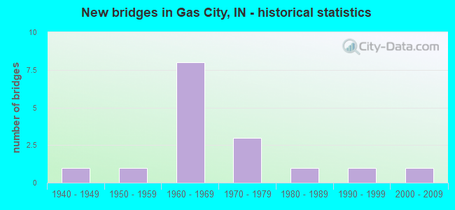
- New bridges - historical statistics
- 11940-1949
- 11950-1959
- 81960-1969
- 31970-1979
- 11980-1989
- 11990-1999
- 12000-2009
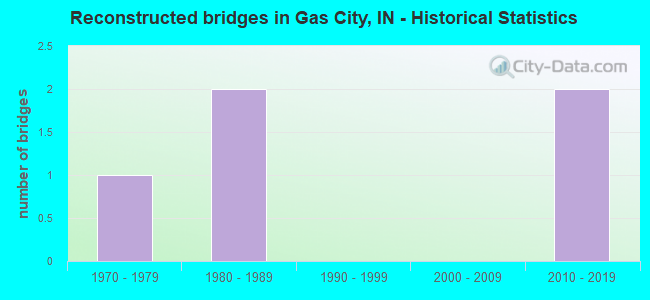
- Reconstructed bridges - Historical Statistics
- 11970-1979
- 21980-1989
- 01990-1999
- 02000-2009
- 22010-2019
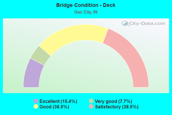
- Bridge Condition - Deck
- 15.4%Excellent
- 7.7%Very good
- 38.5%Good
- 38.5%Satisfactory
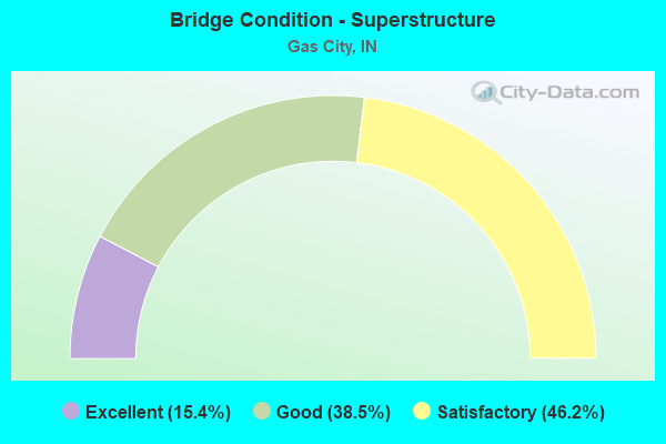
- Bridge Condition - Superstructure
- 15.4%Excellent
- 38.5%Good
- 46.2%Satisfactory
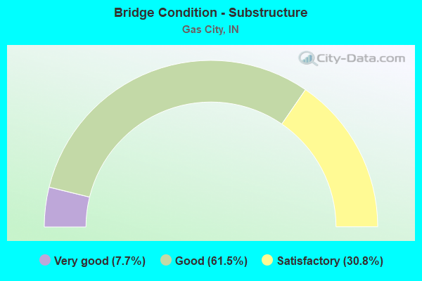
- Bridge Condition - Substructure
- 7.7%Very good
- 61.5%Good
- 30.8%Satisfactory
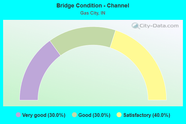
- Bridge Condition - Channel
- 30.0%Very good
- 30.0%Good
- 40.0%Satisfactory
Find on map >> Show street view
Structure Number: 3964, Location: 00.45 S US 35 (Lat: 40.474031, Lng: -85.548961), Route carried "on" structure: Interstate 69, Year Built: 1963, Year Reconstructed: 1993, Status: Open, Structure Length: 4.82m (15.81ft), Average Daily Traffic: 12,895 (year 2020), Truck Traffic: 37%, Average Future Daily Traffic: 23,224 (year 2035), Design Load: HS 20+Mod, Features Intersected: CENTRAL RR CO OF IN
Minimum Vertical Clearance: 30+ m (98+ ft), Kilometerpoint: 416.192, Lanes on structure: 2, Base Highway Network: Yes (, Subroute: 1), Owner: State Highway Agency, Approaching Roadway Width: 12.8m (42.0ft), Material/Design: Steel continuous, Design/Construction: Stringer/Multi-beam, Number Of Spans In Main Unit: 3, Length of Maximum Span: 18.3m (60.0ft), Curb-To-Curb Width: 12.4m (40.7ft), Out-to-Out Width: 13.3m (43.6ft)
Condition: Deck: Good, Superstructure: Satisfactory, Substructure: Satisfactory, Operating Rating: 55.4 metric tons, Method Used To Determine Operating Rating: Load and Resistance Factor Rating (LRFR) rating reported by rating factor(RF) method using HL-93 loadings, Inventory Rating: 42.8 metric tons, Method Used To Determine Inventory Rating: Load and Resistance Factor Rating (LRFR) rating reported by rating factor(RF) method using HL-93 loadings, Structural Evaluation: Equal to present minimum criteria, Deck Geometry: Better than present minimum criteria, Underclear: Better than present minimum criteria, Approach Roadway Alignment: Equal to present desirable criteria, Designated Inspection Frequency: Every 24 months, Inspection Date: Febuary 2021, Deck Structure Type: Concrete Cast-file-Place, Wearing Surface/Protective System: Wearing Surface: Monolithic Concrete, Deck Protection: Epoxy Coated Reinforcing
Find on map >> Show street view
Structure Number: 3966, Location: 04.12 N SR 26 (Lat: 40.480481, Lng: -85.548881), Route carried "on" structure: Interstate 69, Year Built: 1963, Year Reconstructed: 2021, Status: Open, Structure Length: 4.88m (16.01ft), Average Daily Traffic: 14,463 (year 2021), Truck Traffic: 38%, Average Future Daily Traffic: 23,224 (year 2033), Design Load: HS 20+Mod, Features Intersected: SR 22/US 35 NB
Minimum Vertical Clearance: 30+ m (98+ ft), Kilometerpoint: 416.917, Lanes on structure: 2, Lanes under structure: 2, Base Highway Network: Yes (, Subroute: 1), Owner: State Highway Agency, Approaching Roadway Width: 12.8m (42.0ft), Material/Design: Steel continuous, Design/Construction: Stringer/Multi-beam, Number Of Spans In Main Unit: 4, Length of Maximum Span: 13.3m (43.6ft), Curb-To-Curb Width: 12.4m (40.7ft), Out-to-Out Width: 13.3m (43.6ft)
Condition: Deck: Good, Superstructure: Good, Substructure: Good, Operating Rating: 45.0 metric tons, Method Used To Determine Operating Rating: Load and Resistance Factor Rating (LRFR) rating reported by rating factor(RF) method using HL-93 loadings, Inventory Rating: 45.0 metric tons, Method Used To Determine Inventory Rating: Load and Resistance Factor Rating (LRFR) rating reported by rating factor(RF) method using HL-93 loadings, Structural Evaluation: Better than present minimum criteria, Deck Geometry: Better than present minimum criteria, Underclear: Meets minimum limits, Approach Roadway Alignment: Equal to present desirable criteria, Designated Inspection Frequency: Every 24 months, Inspection Date: October 2020, Deck Structure Type: Concrete Cast-file-Place, Wearing Surface/Protective System: Wearing Surface: Monolithic Concrete, Deck Protection: Epoxy Coated Reinforcing
Find on map >> Show street view
Structure Number: 3967, Location: 04.12 N SR 26 (Lat: 40.480469, Lng: -85.549200), Route carried "on" structure: Interstate 69, Year Built: 1963, Year Reconstructed: 2017, Status: Open, Structure Length: 4.88m (16.01ft), Average Daily Traffic: 14,160 (year 2019), Truck Traffic: 26%, Average Future Daily Traffic: 23,224 (year 2029), Design Load: HS 20+Mod, Features Intersected: SR 22/US 35 NB
Minimum Vertical Clearance: 30+ m (98+ ft), Kilometerpoint: 416.917, Lanes on structure: 2, Lanes under structure: 2, Base Highway Network: Yes (, Subroute: 1), Owner: State Highway Agency, Approaching Roadway Width: 12.8m (42.0ft), Material/Design: Steel continuous, Design/Construction: Stringer/Multi-beam, Number Of Spans In Main Unit: 4, Length of Maximum Span: 13.3m (43.6ft), Curb-To-Curb Width: 12.4m (40.7ft), Out-to-Out Width: 13.3m (43.6ft)
Condition: Deck: Good, Superstructure: Good, Substructure: Satisfactory, Operating Rating: 57.0 metric tons, Method Used To Determine Operating Rating: Load and Resistance Factor Rating (LRFR) rating reported by rating factor(RF) method using HL-93 loadings, Inventory Rating: 43.7 metric tons, Method Used To Determine Inventory Rating: Load and Resistance Factor Rating (LRFR) rating reported by rating factor(RF) method using HL-93 loadings, Structural Evaluation: Equal to present minimum criteria, Deck Geometry: Better than present minimum criteria, Underclear: Meets minimum limits, Approach Roadway Alignment: Equal to present desirable criteria, Designated Inspection Frequency: Every 24 months, Inspection Date: October 2020, Deck Structure Type: Concrete Cast-file-Place, Wearing Surface/Protective System: Wearing Surface: Monolithic Concrete, Deck Protection: Epoxy Coated Reinforcing
Find on map >> Show street view
Structure Number: 3968, Location: 01.20 N US 35 (Lat: 40.498050, Lng: -85.549061), Route carried "on" structure: Interstate 69, Year Built: 1963, Year Reconstructed: 2021, Status: Open, Structure Length: 3.11m (10.20ft), Average Daily Traffic: 14,051 (year 2021), Truck Traffic: 38%, Average Future Daily Traffic: 19,820 (year 2040), Design Load: HL 93, Features Intersected: WALNUT CREEK
Minimum Vertical Clearance: 30+ m (98+ ft), Kilometerpoint: 418.848, Lanes on structure: 2, Base Highway Network: Yes (, Subroute: 1), Owner: State Highway Agency, Approaching Roadway Width: 12.3m (40.4ft), Skew: 1 degrees, Material/Design: Concrete continuous, Design/Construction: Slab, Number Of Spans In Main Unit: 3, Length of Maximum Span: 12.0m (39.4ft), Curb-To-Curb Width: 12.3m (40.4ft), Out-to-Out Width: 13.3m (43.6ft)
Condition: Deck: Excellent, Superstructure: Excellent, Substructure: Very good, Channel: Very good, Operating Rating: 42.8 metric tons, Method Used To Determine Operating Rating: Load and Resistance Factor Rating (LRFR) rating reported by rating factor(RF) method using HL-93 loadings, Inventory Rating: 33.0 metric tons, Method Used To Determine Inventory Rating: Load and Resistance Factor Rating (LRFR) rating reported by rating factor(RF) method using HL-93 loadings, Structural Evaluation: Equal to present desirable criteria, Deck Geometry: Better than present minimum criteria, Waterway Adequacy: Better than present minimum criteria, Approach Roadway Alignment: Equal to present desirable criteria, Designated Inspection Frequency: Every 24 months, Inspection Date: March 2021, Deck Structure Type: Concrete Cast-file-Place, Wearing Surface/Protective System: Wearing Surface: Monolithic Concrete, Deck Protection: Epoxy Coated Reinforcing
Find on map >> Show street view
Structure Number: 3969, Location: 01.20 N US 35 (Lat: 40.497981, Lng: -85.549369), Route carried "on" structure: Interstate 69, Year Built: 1963, Year Reconstructed: 2021, Status: Open, Structure Length: 3.10m (10.17ft), Average Daily Traffic: 15,470 (year 2020), Truck Traffic: 41%, Average Future Daily Traffic: 19,170 (year 2040), Design Load: HL 93, Features Intersected: WALNUT CREEK
Minimum Vertical Clearance: 30+ m (98+ ft), Kilometerpoint: 418.848, Lanes on structure: 2, Base Highway Network: Yes (, Subroute: 1), Owner: State Highway Agency, Approaching Roadway Width: 12.3m (40.4ft), Skew: 1 degrees, Material/Design: Concrete continuous, Design/Construction: Slab, Number Of Spans In Main Unit: 3, Length of Maximum Span: 12.0m (39.4ft), Curb-To-Curb Width: 12.3m (40.4ft), Out-to-Out Width: 13.3m (43.6ft)
Condition: Deck: Excellent, Superstructure: Excellent, Substructure: Good, Channel: Very good, Operating Rating: 42.8 metric tons, Method Used To Determine Operating Rating: Load and Resistance Factor Rating (LRFR) rating reported by rating factor(RF) method using HL-93 loadings, Inventory Rating: 33.0 metric tons, Method Used To Determine Inventory Rating: Load and Resistance Factor Rating (LRFR) rating reported by rating factor(RF) method using HL-93 loadings, Structural Evaluation: Better than present minimum criteria, Deck Geometry: Better than present minimum criteria, Waterway Adequacy: Better than present minimum criteria, Approach Roadway Alignment: Equal to present desirable criteria, Designated Inspection Frequency: Every 24 months, Inspection Date: March 2021, Deck Structure Type: Concrete Cast-file-Place, Wearing Surface/Protective System: Wearing Surface: Monolithic Concrete, Deck Protection: Epoxy Coated Reinforcing
Find on map >> Show street view
Structure Number: 2700053, Location: 00.86 MI N of SR 22 (Lat: 40.500450, Lng: -85.595919), Route carried "on" structure: County highway 255, Year Built: 1976, Year Reconstructed: 2015, Status: Open, Structure Length: 4.65m (15.26ft), Average Daily Traffic: 3,790 (year 2021), Truck Traffic: 10%, Average Future Daily Traffic: 5,790 (year 2041), Design Load: HS 20, Features Intersected: WALNUT CREEK, Facility Carried by Structure: CR 400E
Minimum Vertical Clearance: 30+ m (98+ ft), Kilometerpoint: 0.000, Lanes on structure: 2, Owner: County Highway Agency, Approaching Roadway Width: 6.7m (22.0ft), Material/Design: Prestressed concrete, Design/Construction: Box Beam or Girders - Multiple, Number Of Spans In Main Unit: 3, Length of Maximum Span: 15.2m (49.9ft), Curb-To-Curb Width: 9.0m (29.5ft), Out-to-Out Width: 9.1m (29.9ft)
Condition: Deck: Very good, Superstructure: Good, Substructure: Good, Channel: Good, Operating Rating: 43.5 metric tons, Method Used To Determine Operating Rating: Load Factor (LF), Inventory Rating: 33.6 metric tons, Method Used To Determine Inventory Rating: Load Factor (LF), Structural Evaluation: Better than present minimum criteria, Deck Geometry: Meets minimum limits, Waterway Adequacy: Better than present minimum criteria, Approach Roadway Alignment: Equal to present desirable criteria, Designated Inspection Frequency: Every 24 months, Inspection Date: October 2021, Deck Structure Type: Concrete Cast-file-Place, Wearing Surface/Protective System: Wearing Surface: Monolithic Concrete
Find on map >> Show street view
Structure Number: 2700054, Location: 00.97 MI N of SR 22 (Lat: 40.494869, Lng: -85.576850), Route carried "on" structure: County highway 43, Year Built: 1976, Status: Open, Structure Length: 3.32m (10.89ft), Average Daily Traffic: 1,160 (year 2021), Truck Traffic: 5%, Average Future Daily Traffic: 1,770 (year 2041), Design Load: HS 20, Features Intersected: WALNUT CREEK, Facility Carried by Structure: CR 500E
Minimum Vertical Clearance: 30+ m (98+ ft), Kilometerpoint: 0.000, Lanes on structure: 2, Owner: County Highway Agency, Approaching Roadway Width: 5.5m (18.0ft), Material/Design: Prestressed concrete, Design/Construction: Box Beam or Girders - Multiple, Number Of Spans In Main Unit: 3, Length of Maximum Span: 11.0m (36.1ft), Curb-To-Curb Width: 7.3m (24.0ft), Out-to-Out Width: 7.4m (24.3ft)
Condition: Deck: Satisfactory, Superstructure: Satisfactory, Substructure: Satisfactory, Channel: Satisfactory, Operating Rating: 39.5 metric tons, Method Used To Determine Operating Rating: Load Factor (LF), Inventory Rating: 30.5 metric tons, Method Used To Determine Inventory Rating: Load Factor (LF), Structural Evaluation: Equal to present minimum criteria, Deck Geometry: Meets minimum limits, Waterway Adequacy: Better than present minimum criteria, Approach Roadway Alignment: Equal to present minimum criteria, Designated Inspection Frequency: Every 24 months, Inspection Date: October 2021, Deck Structure Type: Concrete Precast Panels, Wearing Surface/Protective System: Wearing Surface: Bituminous
Find on map >> Show street view
Structure Number: 2700057, Location: 01.00 MI N of SR 22 (Lat: 40.494881, Lng: -85.558439), Route carried "on" structure: County highway 49, Year Built: 1940, Year Reconstructed: 1970, Status: Open, Structure Length: 1.88m (6.17ft), Average Daily Traffic: 1,500 (year 2021), Truck Traffic: 5%, Average Future Daily Traffic: 2,290 (year 2041), Design Load: HS 20, Features Intersected: WALNUT CREEK, Facility Carried by Structure: CR 600E
Minimum Vertical Clearance: 30+ m (98+ ft), Kilometerpoint: 0.000, Lanes on structure: 2, Owner: County Highway Agency, Approaching Roadway Width: 5.8m (19.0ft), Material/Design: Prestressed concrete, Design/Construction: Box Beam or Girders - Multiple, Number Of Spans In Main Unit: 1, Length of Maximum Span: 18.5m (60.7ft), Curb-To-Curb Width: 7.3m (24.0ft), Out-to-Out Width: 7.4m (24.3ft)
Condition: Deck: Satisfactory, Superstructure: Satisfactory, Substructure: Satisfactory, Channel: Satisfactory, Operating Rating: 43.3 metric tons, Method Used To Determine Operating Rating: Load Factor (LF), Inventory Rating: 33.4 metric tons, Method Used To Determine Inventory Rating: Load Factor (LF), Structural Evaluation: Equal to present minimum criteria, Deck Geometry: Meets minimum limits, Waterway Adequacy: Better than present minimum criteria, Approach Roadway Alignment: Equal to present minimum criteria, Designated Inspection Frequency: Every 24 months, Inspection Date: October 2021, Deck Structure Type: Concrete Precast Panels, Wearing Surface/Protective System: Wearing Surface: Bituminous
Find on map >> Show street view
Structure Number: 2700058, Location: 00.97 MI N of SR 22 (Lat: 40.501969, Lng: -85.615431), Route carried "on" structure: City street , Year Built: 1964, Status: Open, Structure Length: 3.89m (12.76ft), Average Daily Traffic: 5,000 (year 2021), Truck Traffic: 10%, Average Future Daily Traffic: 7,640 (year 2041), Features Intersected: WALNUT CREEK, Facility Carried by Structure: FIRST ST
Minimum Vertical Clearance: 30+ m (98+ ft), Kilometerpoint: 0.000, Lanes on structure: 2, Owner: County Highway Agency, Approaching Roadway Width: 7.3m (24.0ft), Skew: 4 degrees, Material/Design: Concrete continuous, Design/Construction: Slab, Number Of Spans In Main Unit: 3, Length of Maximum Span: 14.6m (47.9ft), Curb or Sidewalk Widths: Left: 0.2m (0.7ft), Right: 0.2m (0.7ft), Curb-To-Curb Width: 9.3m (30.5ft), Out-to-Out Width: 10.1m (33.1ft)
Condition: Deck: Satisfactory, Superstructure: Satisfactory, Substructure: Good, Channel: Good, Operating Rating: 36.7 metric tons, Method Used To Determine Operating Rating: Load Factor (LF), Inventory Rating: 28.3 metric tons, Method Used To Determine Inventory Rating: Load Factor (LF), Structural Evaluation: Equal to present minimum criteria, Deck Geometry: Meets minimum limits, Waterway Adequacy: Better than present minimum criteria, Approach Roadway Alignment: Equal to present desirable criteria, Designated Inspection Frequency: Every 24 months, Inspection Date: October 2021, Deck Structure Type: Concrete Cast-file-Place, Wearing Surface/Protective System: Wearing Surface: Monolithic Concrete
Find on map >> Show street view
Structure Number: 2700065, Location: 01.42 N SR 22 (Lat: 40.500981, Lng: -85.540219), Route carried "on" structure: County highway 257, Year Built: 1975, Status: Open, Structure Length: 1.83m (6.00ft), Average Daily Traffic: 610 (year 2021), Truck Traffic: 5%, Average Future Daily Traffic: 930 (year 2041), Design Load: HS 20, Features Intersected: WALNUT CREEK, Facility Carried by Structure: CR 700E
Minimum Vertical Clearance: 30+ m (98+ ft), Kilometerpoint: 0.000, Lanes on structure: 2, Owner: County Highway Agency, Approaching Roadway Width: 5.8m (19.0ft), Material/Design: Prestressed concrete, Design/Construction: Box Beam or Girders - Multiple, Number Of Spans In Main Unit: 1, Length of Maximum Span: 17.7m (58.1ft), Curb-To-Curb Width: 7.4m (24.3ft), Out-to-Out Width: 7.4m (24.3ft)
Condition: Deck: Satisfactory, Superstructure: Satisfactory, Substructure: Good, Channel: Satisfactory, Operating Rating: 51.1 metric tons, Method Used To Determine Operating Rating: Load Factor (LF), Inventory Rating: 39.4 metric tons, Method Used To Determine Inventory Rating: Load Factor (LF), Structural Evaluation: Equal to present minimum criteria, Deck Geometry: Meets minimum limits, Waterway Adequacy: Better than present minimum criteria, Approach Roadway Alignment: Equal to present desirable criteria, Designated Inspection Frequency: Every 24 months, Inspection Date: October 2021, Deck Structure Type: Concrete Precast Panels, Wearing Surface/Protective System: Wearing Surface: Bituminous
Find on map >> Show street view
Structure Number: 2700105, Location: 00.43 MI N of WHEELING PI (Lat: 40.455850, Lng: -85.577869), Route carried "on" structure: County highway 43, Year Built: 1957, Year Reconstructed: 1988, Status: Open, Structure Length: 9.29m (30.48ft), Average Daily Traffic: 1,580 (year 2021), Truck Traffic: 10%, Average Future Daily Traffic: 2,410 (year 2041), Design Load: HS 20, Features Intersected: MISSISSINEWA RIVER, Facility Carried by Structure: CR 500E
Minimum Vertical Clearance: 30+ m (98+ ft), Kilometerpoint: 0.000, Lanes on structure: 2, Owner: County Highway Agency, Approaching Roadway Width: 6.1m (20.0ft), Material/Design: Concrete continuous, Design/Construction: Stringer/Multi-beam, Number Of Spans In Main Unit: 5, Length of Maximum Span: 20.8m (68.2ft), Curb-To-Curb Width: 7.9m (25.9ft), Out-to-Out Width: 8.7m (28.5ft)
Condition: Deck: Satisfactory, Superstructure: Satisfactory, Substructure: Good, Channel: Good, Operating Rating: 42.3 metric tons, Method Used To Determine Operating Rating: Field evaluation and documented engineering judgment, Inventory Rating: 32.7 metric tons, Method Used To Determine Inventory Rating: Field evaluation and documented engineering judgment, Structural Evaluation: Equal to present minimum criteria, Deck Geometry: Meets minimum limits, Waterway Adequacy: Better than present minimum criteria, Approach Roadway Alignment: Equal to present desirable criteria, Designated Inspection Frequency: Every 24 months, Inspection Date: October 2021, Deck Structure Type: Concrete Cast-file-Place, Wearing Surface/Protective System: Wearing Surface: Monolithic Concrete, Deck Protection: Epoxy Coated Reinforcing
Find on map >> Show street view
Structure Number: 2700177, Location: 00.76 MI E of CR 400 E (Lat: 40.509769, Lng: -85.581769), Route carried "on" structure: County highway 40, Year Built: 1980, Status: Open, Structure Length: 0.78m (2.56ft), Average Daily Traffic: 500 (year 2021), Truck Traffic: 5%, Average Future Daily Traffic: 760 (year 2041), Design Load: HS 20, Features Intersected: BRANCH OF WALNUT CREEK, Facility Carried by Structure: CR 300S
Minimum Vertical Clearance: 30+ m (98+ ft), Kilometerpoint: 0.000, Lanes on structure: 2, Owner: County Highway Agency, Approaching Roadway Width: 4.9m (16.1ft), Skew: 3 degrees, Material/Design: Prestressed concrete, Design/Construction: Box Beam or Girders - Multiple, Number Of Spans In Main Unit: 1, Length of Maximum Span: 7.5m (24.6ft), Curb-To-Curb Width: 7.1m (23.3ft), Out-to-Out Width: 7.3m (24.0ft)
Condition: Deck: Good, Superstructure: Good, Substructure: Good, Channel: Satisfactory, Operating Rating: 53.2 metric tons, Method Used To Determine Operating Rating: Load Factor (LF), Inventory Rating: 41.0 metric tons, Method Used To Determine Inventory Rating: Load Factor (LF), Structural Evaluation: Better than present minimum criteria, Deck Geometry: Meets minimum limits, Waterway Adequacy: Better than present minimum criteria, Approach Roadway Alignment: Equal to present minimum criteria, Designated Inspection Frequency: Every 24 months, Inspection Date: October 2021, Deck Structure Type: Concrete Precast Panels, Wearing Surface/Protective System: Wearing Surface: Bituminous
Find on map >> Show street view
Structure Number: 2700193, Location: 00.23 MI W GARTHWAITE RD (Lat: 40.521189, Lng: -85.620011), Route carried "on" structure: County highway , Year Built: 1997, Status: Open, Structure Length: 1.65m (5.41ft), Average Daily Traffic: 130 (year 2021), Truck Traffic: 5%, Average Future Daily Traffic: 200 (year 2041), Design Load: HL 93, Features Intersected: BROOKHAVEN ADDITION LAKE, Facility Carried by Structure: EASTRIDGE DR
Minimum Vertical Clearance: 30+ m (98+ ft), Kilometerpoint: 0.000, Lanes on structure: 2, Owner: County Highway Agency, Approaching Roadway Width: 6.1m (20.0ft), Material/Design: Wood or Timber, Design/Construction: Slab, Number Of Spans In Main Unit: 3, Length of Maximum Span: 5.5m (18.0ft), Curb or Sidewalk Widths: Left: 0.2m (0.7ft), Right: 0.2m (0.7ft), Curb-To-Curb Width: 7.3m (24.0ft), Out-to-Out Width: 7.8m (25.6ft)
Condition: Deck: Good, Superstructure: Good, Substructure: Good, Channel: Very good, Operating Rating: 49.2 metric tons, Method Used To Determine Operating Rating: Load and Resistance Factor Rating (LRFR) rating reported by rating factor(RF) method using HL-93 loadings, Inventory Rating: 37.9 metric tons, Method Used To Determine Inventory Rating: Load and Resistance Factor Rating (LRFR) rating reported by rating factor(RF) method using HL-93 loadings, Structural Evaluation: Better than present minimum criteria, Deck Geometry: Somewhat better than minimum adequacy, Waterway Adequacy: Better than present minimum criteria, Approach Roadway Alignment: Equal to present desirable criteria, Designated Inspection Frequency: Every 24 months, Inspection Date: October 2021, Deck Structure Type: Wood or Timber, Wearing Surface/Protective System: Wearing Surface: Bituminous, Deck Protection: Internally Sealed
Find on map >> Show street view
Structure Number: 3966, Location: 04.12 N SR 26 (Lat: 40.480481, Lng: -85.548889), Route carried "under" structure: US 35, Year Built: 1963, Structure Length: 0. m, Average Daily Traffic: 14,629 (year 2019), Truck Traffic: 20%, Features Intersected: SR 22/US 35 NB, Facility Carried by Structure: I-69 NB
Minimum Vertical Clearance: 4.44m (14.57ft), Kilometerpoint: 11.716, Lanes on structure: 2, Lanes under structure: 2, Material/Design: Steel continuous, Design/Construction: Stringer/Multi-beam, Length of Maximum Span: 13.3m (43.6ft)
Find on map >> Show street view
Structure Number: 3967, Location: 04.12 N SR 26 (Lat: 40.480469, Lng: -85.549203), Route carried "under" structure: US 35, Year Built: 1963, Structure Length: 0. m, Average Daily Traffic: 7,953 (year 2019), Truck Traffic: 5%, Features Intersected: SR 22/US 35, Facility Carried by Structure: I-69 SB
Minimum Vertical Clearance: 4.62m (15.16ft), Kilometerpoint: 11.716, Lanes on structure: 2, Lanes under structure: 2, Material/Design: Steel continuous, Design/Construction: Stringer/Multi-beam, Length of Maximum Span: 13.3m (43.6ft)
Find on map >> Show street view
Structure Number: 4659, Location: 00.66 E US 12 (Lat: 41.589281, Lng: -87.304161), Route carried "under" structure: Ramp Interstate 90, Year Built: 2003, Structure Length: 0. m, Average Daily Traffic: 1,076 (year 2011), Truck Traffic: 5%, Features Intersected: I-90 WB RAMP
Minimum Vertical Clearance: 4.93m (16.17ft), Kilometerpoint: 27.198, Lanes on structure: 2, Lanes under structure: 1, Toll: On toll road, Material/Design: Steel continuous, Design/Construction: Stringer/Multi-beam, Length of Maximum Span: 29.5m (96.8ft)