Bridge Statistics for Gatesville, Texas (TX)
Condition, Traffic, Stress, Structural Evaluation, Project Costs
- National Bridge Inventory (NBI) Statistics
- 32Number of bridges
- 456ft / 139mTotal length
- $18,910,000Total costs
- 134,416Total average daily traffic
- 16,614Total average daily truck traffic
- National Bridge Inventory (NBI) Registered Bridges for Gatesville
- No street view available for this location
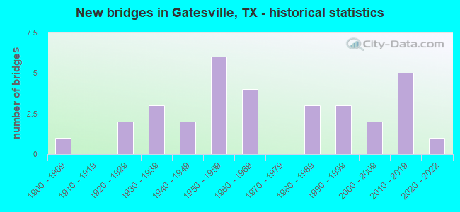
- New bridges - historical statistics
- 11900-1909
- 21920-1929
- 31930-1939
- 21940-1949
- 61950-1959
- 41960-1969
- 31980-1989
- 31990-1999
- 22000-2009
- 52010-2019
- 12020-2022
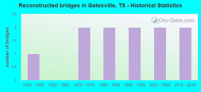
- Reconstructed bridges - Historical Statistics
- 11950-1959
- 01960-1969
- 21970-1979
- 21980-1989
- 21990-1999
- 22000-2009
- 22010-2019
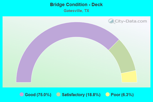
- Bridge Condition - Deck
- 75.0%Good
- 18.8%Satisfactory
- 6.3%Poor
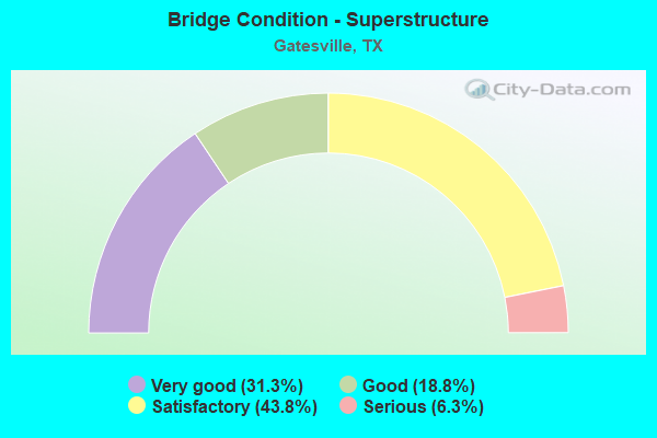
- Bridge Condition - Superstructure
- 31.3%Very good
- 18.8%Good
- 43.8%Satisfactory
- 6.3%Serious
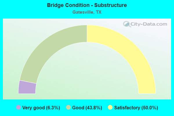
- Bridge Condition - Substructure
- 6.3%Very good
- 43.8%Good
- 50.0%Satisfactory
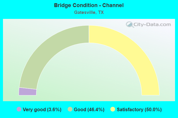
- Bridge Condition - Channel
- 3.6%Very good
- 46.4%Good
- 50.0%Satisfactory
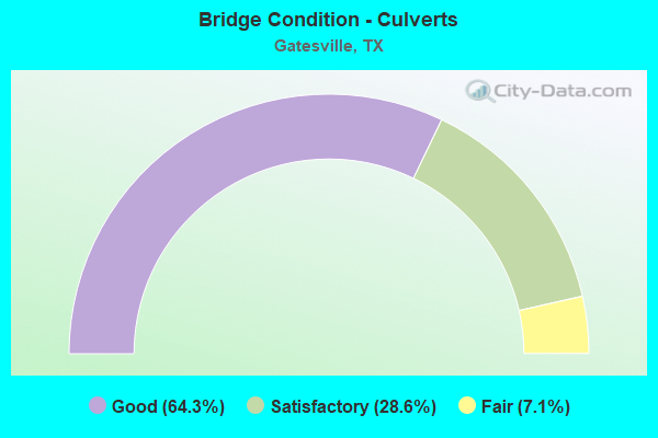
- Bridge Condition - Culverts
- 64.3%Good
- 28.6%Satisfactory
- 7.1%Fair
Find on map >> Show street view
Structure Number: 9050000550404, Location: 0.37 MI W OF FM 116 (Lat: 31.434308, Lng: -97.789272), Route carried "on" structure: US 84, Year Built: 1938, Year Reconstructed: 1964, Status: Open, Structure Length: 4.88m (16.01ft), Average Daily Traffic: 3,892 (year 2020), Truck Traffic: 13%, Average Future Daily Traffic: 4,720 (year 2033), Design Load: H 15, Features Intersected: DODDS CREEK
Minimum Vertical Clearance: 30+ m (98+ ft), Kilometerpoint: 10.968, Lanes on structure: 2, Owner: State Highway Agency, Approaching Roadway Width: 14.0m (45.9ft), Material/Design: Steel, Design/Construction: Stringer/Multi-beam, Number Of Spans In Main Unit: 4, Length of Maximum Span: 12.2m (40.0ft), Curb-To-Curb Width: 12.8m (42.0ft), Out-to-Out Width: 13.5m (44.3ft)
Condition: Deck: Good, Superstructure: Satisfactory, Substructure: Good, Channel: Good, Operating Rating: 47.2 metric tons, Method Used To Determine Operating Rating: Load Factor (LF), Inventory Rating: 28.1 metric tons, Method Used To Determine Inventory Rating: Load Factor (LF), Structural Evaluation: Equal to present minimum criteria, Deck Geometry: Equal to present minimum criteria, Waterway Adequacy: Equal to present minimum criteria, Approach Roadway Alignment: Equal to present desirable criteria, Length Of Structure Improvement: 6.40m (21.00ft), Designated Inspection Frequency: Every 24 months, Inspection Date: December 2020, Bridge Improvement Cost: $1,000,000, Roadway Improvement Cost: $300,000, Total Project Cost: $1,500,000, Deck Structure Type: Concrete Cast-file-Place, Wearing Surface/Protective System: Wearing Surface: Bituminous
Find on map >> Show street view
Structure Number: 90500005504041, Location: 2.66 MI W OF SH 36 (Lat: 31.434947, Lng: -97.761650), Route carried "on" structure: US 84, Year Built: 1938, Year Reconstructed: 1970, Status: Open, Structure Length: 28.80m (94.49ft), Average Daily Traffic: 15,877 (year 2020), Truck Traffic: 13%, Average Future Daily Traffic: 16,150 (year 2033), Design Load: H 15, Features Intersected: LEON RIVER
Minimum Vertical Clearance: 30+ m (98+ ft), Kilometerpoint: 13.663, Lanes on structure: 4, Owner: State Highway Agency, Approaching Roadway Width: 19.5m (64.0ft), Material/Design: Steel continuous, Design/Construction: Stringer/Multi-beam, Number Of Spans In Main Unit: 3, Number Of Approach Spans: 18, Length of Maximum Span: 27.4m (89.9ft), Curb-To-Curb Width: 20.7m (67.9ft), Out-to-Out Width: 21.4m (70.2ft)
Condition: Deck: Satisfactory, Superstructure: Satisfactory, Substructure: Satisfactory, Channel: Satisfactory, Operating Rating: 49.0 metric tons, Method Used To Determine Operating Rating: Load Factor (LF), Inventory Rating: 29.0 metric tons, Method Used To Determine Inventory Rating: Load Factor (LF), Structural Evaluation: Equal to present minimum criteria, Deck Geometry: Superior to present desirable criteria, Waterway Adequacy: Equal to present minimum criteria, Approach Roadway Alignment: Equal to present desirable criteria, Length Of Structure Improvement: 36.00m (118.11ft), Designated Inspection Frequency: Every 24 months, Inspection Date: December 2020, Bridge Improvement Cost: $3,500,000, Roadway Improvement Cost: $900,000, Total Project Cost: $5,300,000, Deck Structure Type: Concrete Cast-file-Place, Wearing Surface/Protective System: Wearing Surface: Bituminous
Find on map >> Show street view
Structure Number: 90500005505022, Location: 0.90 MI E OF SH 36 (Lat: 31.430906, Lng: -97.700658), Route carried "on" structure: US 84, Year Built: 1934, Year Reconstructed: 1996, Status: Open, Structure Length: 1.01m (3.31ft), Average Daily Traffic: 13,738 (year 2020), Truck Traffic: 10%, Average Future Daily Traffic: 11,520 (year 2033), Design Load: H 15, Features Intersected: ROCK CREEK
Minimum Vertical Clearance: 30+ m (98+ ft), Kilometerpoint: 43.594, Lanes on structure: 5, Owner: State Highway Agency, Approaching Roadway Width: 25.6m (84.0ft), Material/Design: Concrete, Design/Construction: Culvert, Number Of Spans In Main Unit: 3, Length of Maximum Span: 3.0m (9.8ft)
Condition: Channel: Satisfactory, Culverts: Satisfactory, Operating Rating: 32.7 metric tons, Method Used To Determine Operating Rating: Field evaluation and documented engineering judgment, Inventory Rating: 24.5 metric tons, Method Used To Determine Inventory Rating: Field evaluation and documented engineering judgment, Structural Evaluation: Equal to present minimum criteria, Waterway Adequacy: Equal to present minimum criteria, Approach Roadway Alignment: Equal to present desirable criteria, Length Of Structure Improvement: 1.83m (6.00ft), Designated Inspection Frequency: Every 24 months, Inspection Date: November 2020, Bridge Improvement Cost: $200,000, Roadway Improvement Cost: $100,000, Total Project Cost: $300,000
Find on map >> Show street view
Structure Number: 90500005505067, Location: 2.60 MI S OF FM 929 (Lat: 31.434150, Lng: -97.714828), Route carried "on" structure: State highway 36, Year Built: 1986, Status: Open, Structure Length: 9.66m (31.69ft), Average Daily Traffic: 6,930 (year 2013), Truck Traffic: 17%, Average Future Daily Traffic: 9,700 (year 2033), Design Load: HS 20, Features Intersected: US 84
Minimum Vertical Clearance: 30+ m (98+ ft), Kilometerpoint: 26.491, Lanes on structure: 2, Lanes under structure: 5, Owner: State Highway Agency, Approaching Roadway Width: 12.8m (42.0ft), Material/Design: Prestressed concrete, Design/Construction: Stringer/Multi-beam, Number Of Spans In Main Unit: 1, Number Of Approach Spans: 2, Length of Maximum Span: 38.7m (127.0ft), Curb-To-Curb Width: 11.3m (37.1ft), Out-to-Out Width: 12.2m (40.0ft)
Condition: Deck: Good, Superstructure: Satisfactory, Substructure: Satisfactory, Operating Rating: 54.4 metric tons, Method Used To Determine Operating Rating: Assigned rating based on Load Factor Design (LFD) reported in metric tons, Inventory Rating: 32.7 metric tons, Method Used To Determine Inventory Rating: Assigned rating based on Load Factor Design (LFD) reported in metric tons, Structural Evaluation: Equal to present minimum criteria, Deck Geometry: Meets minimum limits, Underclear: Better than present minimum criteria, Approach Roadway Alignment: Equal to present desirable criteria, Designated Inspection Frequency: Every 24 months, Inspection Date: October 2020, Deck Structure Type: Concrete Cast-file-Place, Wearing Surface/Protective System: Wearing Surface: Bituminous
Find on map >> Show street view
Structure Number: 90500018304053, Location: 0.67 MI NW OF FM 215 (Lat: 31.490711, Lng: -97.741297), Route carried "on" structure: State highway 36, Year Built: 1955, Year Reconstructed: 1986, Status: Open, Structure Length: 1.07m (3.51ft), Average Daily Traffic: 3,758 (year 2020), Truck Traffic: 9%, Average Future Daily Traffic: 6,360 (year 2033), Features Intersected: FOUR MILE CREEK
Minimum Vertical Clearance: 30+ m (98+ ft), Kilometerpoint: 19.328, Lanes on structure: 2, Owner: State Highway Agency, Approaching Roadway Width: 11.0m (36.1ft), Skew: 9 degrees, Material/Design: Concrete, Design/Construction: Culvert, Number Of Spans In Main Unit: 3, Length of Maximum Span: 3.0m (9.8ft)
Condition: Channel: Good, Culverts: Good, Operating Rating: 39.9 metric tons, Method Used To Determine Operating Rating: Load Factor (LF), Inventory Rating: 23.6 metric tons, Method Used To Determine Inventory Rating: Load Factor (LF), Structural Evaluation: Equal to present minimum criteria, Waterway Adequacy: Superior to present desirable criteria, Approach Roadway Alignment: Equal to present desirable criteria, Length Of Structure Improvement: 1.83m (6.00ft), Designated Inspection Frequency: Every 24 months, Inspection Date: November 2020, Bridge Improvement Cost: $200,000, Roadway Improvement Cost: $100,000, Total Project Cost: $300,000
Find on map >> Show street view
Structure Number: 90500018304054, Location: 0.84 MI NW OF FM 182 (Lat: 31.513150, Lng: -97.771961), Route carried "on" structure: State highway 36, Year Built: 1955, Year Reconstructed: 2018, Status: Open, Structure Length: 0.88m (2.89ft), Average Daily Traffic: 3,015 (year 2020), Truck Traffic: 17%, Average Future Daily Traffic: 5,030 (year 2033), Features Intersected: TRIB LEON RIVER
Minimum Vertical Clearance: 30+ m (98+ ft), Kilometerpoint: 15.429, Lanes on structure: 2, Owner: State Highway Agency, Approaching Roadway Width: 10.1m (33.1ft), Material/Design: Concrete, Design/Construction: Culvert, Number Of Spans In Main Unit: 3, Length of Maximum Span: 2.7m (8.9ft)
Condition: Channel: Satisfactory, Culverts: Good, Operating Rating: 39.9 metric tons, Method Used To Determine Operating Rating: Load Factor (LF), Inventory Rating: 23.6 metric tons, Method Used To Determine Inventory Rating: Load Factor (LF), Structural Evaluation: Equal to present minimum criteria, Waterway Adequacy: Superior to present desirable criteria, Approach Roadway Alignment: Equal to present desirable criteria, Length Of Structure Improvement: 1.83m (6.00ft), Designated Inspection Frequency: Every 24 months, Inspection Date: November 2020, Bridge Improvement Cost: $200,000, Roadway Improvement Cost: $100,000, Total Project Cost: $300,000
Find on map >> Show street view
Structure Number: 90500018304055, Location: 0.98 MI NW OF FM 182 (Lat: 31.514581, Lng: -97.773406), Route carried "on" structure: State highway 36, Year Built: 1955, Year Reconstructed: 2018, Status: Open, Structure Length: 1.16m (3.81ft), Average Daily Traffic: 3,015 (year 2020), Truck Traffic: 17%, Average Future Daily Traffic: 5,030 (year 2033), Features Intersected: TRIB LEON RIVER
Minimum Vertical Clearance: 30+ m (98+ ft), Kilometerpoint: 15.218, Lanes on structure: 2, Owner: State Highway Agency, Approaching Roadway Width: 10.1m (33.1ft), Skew: 3 degrees, Material/Design: Concrete, Design/Construction: Culvert, Number Of Spans In Main Unit: 3, Length of Maximum Span: 3.0m (9.8ft)
Condition: Channel: Good, Culverts: Satisfactory, Operating Rating: 39.9 metric tons, Method Used To Determine Operating Rating: Load Factor (LF), Inventory Rating: 23.6 metric tons, Method Used To Determine Inventory Rating: Load Factor (LF), Structural Evaluation: Equal to present minimum criteria, Waterway Adequacy: Superior to present desirable criteria, Approach Roadway Alignment: Equal to present desirable criteria, Length Of Structure Improvement: 1.83m (6.00ft), Designated Inspection Frequency: Every 24 months, Inspection Date: November 2020, Bridge Improvement Cost: $200,000, Roadway Improvement Cost: $100,000, Total Project Cost: $300,000
Find on map >> Show street view
Structure Number: 90500018304068, Location: 0.28 MI S OF FM 929 (Lat: 31.467869, Lng: -97.717711), Route carried "on" structure: State highway 36, Year Built: 1986, Status: Open, Structure Length: 1.04m (3.41ft), Average Daily Traffic: 6,672 (year 2020), Truck Traffic: 10%, Average Future Daily Traffic: 5,060 (year 2033), Design Load: HS 20, Features Intersected: STILLHOUSE CREEK
Minimum Vertical Clearance: 30+ m (98+ ft), Kilometerpoint: 2.515, Lanes on structure: 3, Owner: State Highway Agency, Approaching Roadway Width: 16.5m (54.1ft), Skew: 3 degrees, Material/Design: Concrete, Design/Construction: Culvert, Number Of Spans In Main Unit: 3, Length of Maximum Span: 2.7m (8.9ft)
Condition: Channel: Good, Culverts: Good, Operating Rating: 39.9 metric tons, Method Used To Determine Operating Rating: Load Factor (LF), Inventory Rating: 23.6 metric tons, Method Used To Determine Inventory Rating: Load Factor (LF), Structural Evaluation: Somewhat better than minimum adequacy, Waterway Adequacy: Equal to present minimum criteria, Approach Roadway Alignment: Equal to present desirable criteria, Length Of Structure Improvement: 1.83m (6.00ft), Designated Inspection Frequency: Every 48 months, Inspection Date: November 2020, Bridge Improvement Cost: $200,000, Roadway Improvement Cost: $100,000, Total Project Cost: $300,000
Find on map >> Show street view
Structure Number: 90500018304072, Location: 3.80 MI NW OF US 84 (Lat: 31.483100, Lng: -97.733564), Route carried "on" structure: State highway 36, Year Built: 2011, Status: Open, Structure Length: 8.84m (29.00ft), Average Daily Traffic: 5,172 (year 2020), Truck Traffic: 9%, Average Future Daily Traffic: 6,360 (year 2033), Design Load: HL 93, Features Intersected: BUS 36 / FM 215
Minimum Vertical Clearance: 30+ m (98+ ft), Kilometerpoint: 21.020, Lanes on structure: 2, Lanes under structure: 4, Owner: State Highway Agency, Approaching Roadway Width: 12.2m (40.0ft), Skew: 1 degrees, Material/Design: Prestressed concrete, Design/Construction: Stringer/Multi-beam, Number Of Spans In Main Unit: 1, Number Of Approach Spans: 2, Length of Maximum Span: 36.6m (120.1ft), Curb-To-Curb Width: 12.1m (39.7ft), Out-to-Out Width: 12.8m (42.0ft)
Condition: Deck: Good, Superstructure: Very good, Substructure: Good, Operating Rating: 54.4 metric tons, Method Used To Determine Operating Rating: Assigned ratings based on Load and Resistance Factor Design (LRFD) reported in metric tons, Inventory Rating: 32.7 metric tons, Method Used To Determine Inventory Rating: Assigned ratings based on Load and Resistance Factor Design (LRFD) reported in metric tons, Structural Evaluation: Better than present minimum criteria, Deck Geometry: Somewhat better than minimum adequacy, Underclear: Superior to present desirable criteria, Approach Roadway Alignment: Equal to present desirable criteria, Designated Inspection Frequency: Every 24 months, Inspection Date: November 2020, Deck Structure Type: Concrete Precast Panels
Find on map >> Show street view
Structure Number: 90500018304073, Location: 0.18 MI NW OF FM 215 (Lat: 31.485300, Lng: -97.735900), Route carried "on" structure: State highway 36, Year Built: 2011, Status: Open, Structure Length: 0.91m (2.99ft), Average Daily Traffic: 5,172 (year 2020), Truck Traffic: 9%, Average Future Daily Traffic: 6,360 (year 2033), Design Load: HL 93, Features Intersected: TRIB LEON RIVER
Minimum Vertical Clearance: 30+ m (98+ ft), Kilometerpoint: 20.146, Lanes on structure: 4, Owner: State Highway Agency, Approaching Roadway Width: 25.6m (84.0ft), Material/Design: Concrete, Design/Construction: Culvert, Number Of Spans In Main Unit: 3, Length of Maximum Span: 2.7m (8.9ft)
Condition: Channel: Good, Culverts: Good, Operating Rating: 54.4 metric tons, Method Used To Determine Operating Rating: Assigned ratings based on Load and Resistance Factor Design (LRFD) reported in metric tons, Inventory Rating: 32.7 metric tons, Method Used To Determine Inventory Rating: Assigned ratings based on Load and Resistance Factor Design (LRFD) reported in metric tons, Structural Evaluation: Better than present minimum criteria, Waterway Adequacy: Superior to present desirable criteria, Approach Roadway Alignment: Equal to present desirable criteria, Designated Inspection Frequency: Every 24 months, Inspection Date: November 2020
Find on map >> Show street view
Structure Number: 90500018306017, Location: 0.60 MI N OF US 84 (Lat: 31.443772, Lng: -97.744097), Route carried "on" structure: State highway 36, Year Built: 1925, Year Reconstructed: 1984, Status: Open, Structure Length: 3.35m (10.99ft), Average Daily Traffic: 5,000 (year 2013), Truck Traffic: 17%, Average Future Daily Traffic: 7,000 (year 2033), Features Intersected: STILLHOUSE BRANCH
Minimum Vertical Clearance: 30+ m (98+ ft), Kilometerpoint: 4.754, Lanes on structure: 2, Owner: State Highway Agency, Approaching Roadway Width: 12.2m (40.0ft), Material/Design: Concrete, Design/Construction: Slab, Number Of Spans In Main Unit: 5, Length of Maximum Span: 6.7m (22.0ft), Curb-To-Curb Width: 13.4m (44.0ft), Out-to-Out Width: 14.0m (45.9ft)
Condition: Deck: Satisfactory, Superstructure: Satisfactory, Substructure: Satisfactory, Channel: Satisfactory, Operating Rating: 57.1 metric tons, Method Used To Determine Operating Rating: Load Factor (LF), Inventory Rating: 34.5 metric tons, Method Used To Determine Inventory Rating: Load Factor (LF), Structural Evaluation: Equal to present minimum criteria, Deck Geometry: Better than present minimum criteria, Waterway Adequacy: Equal to present minimum criteria, Approach Roadway Alignment: Equal to present desirable criteria, Designated Inspection Frequency: Every 24 months, Inspection Date: November 2020, Deck Structure Type: Concrete Cast-file-Place, Wearing Surface/Protective System: Wearing Surface: Bituminous
Find on map >> Show street view
Structure Number: 90500018401007, Location: 2.53 MI S OF US 84 (Lat: 31.399000, Lng: -97.707689), Route carried "on" structure: State highway 36, Year Built: 1941, Year Reconstructed: 2006, Status: Open, Structure Length: 0.98m (3.22ft), Average Daily Traffic: 9,133 (year 2020), Truck Traffic: 17%, Average Future Daily Traffic: 13,060 (year 2033), Design Load: H 15, Features Intersected: HINSLEY CREEK
Minimum Vertical Clearance: 30+ m (98+ ft), Kilometerpoint: 30.927, Lanes on structure: 5, Owner: State Highway Agency, Approaching Roadway Width: 26.5m (86.9ft), Skew: 4 degrees, Material/Design: Concrete, Design/Construction: Culvert, Number Of Spans In Main Unit: 4, Length of Maximum Span: 1.5m (4.9ft), Curb-To-Curb Width: 26.5m (86.9ft), Out-to-Out Width: 32.9m (107.9ft)
Condition: Channel: Very good, Culverts: Good, Operating Rating: 32.7 metric tons, Method Used To Determine Operating Rating: Field evaluation and documented engineering judgment, Inventory Rating: 24.5 metric tons, Method Used To Determine Inventory Rating: Field evaluation and documented engineering judgment, Structural Evaluation: Equal to present minimum criteria, Deck Geometry: Superior to present desirable criteria, Waterway Adequacy: Equal to present minimum criteria, Approach Roadway Alignment: Equal to present desirable criteria, Length Of Structure Improvement: 1.83m (6.00ft), Designated Inspection Frequency: Every 24 months, Inspection Date: October 2020, Bridge Improvement Cost: $200,000, Roadway Improvement Cost: $100,000, Total Project Cost: $300,000, Deck Structure Type: Concrete Cast-file-Place, Wearing Surface/Protective System: Wearing Surface: Bituminous
Find on map >> Show street view
Structure Number: 90500018401008, Location: 3.60 MI S OF US 84 (Lat: 31.384314, Lng: -97.702061), Route carried "on" structure: State highway 36, Year Built: 1941, Year Reconstructed: 1992, Status: Open, Structure Length: 27.28m (89.50ft), Average Daily Traffic: 5,173 (year 2020), Truck Traffic: 8%, Average Future Daily Traffic: 7,900 (year 2033), Design Load: H 15, Features Intersected: LEON RIVER
Minimum Vertical Clearance: 30+ m (98+ ft), Kilometerpoint: 32.504, Lanes on structure: 3, Owner: State Highway Agency, Approaching Roadway Width: 18.3m (60.0ft), Material/Design: Steel continuous, Design/Construction: Stringer/Multi-beam, Number Of Spans In Main Unit: 3, Number Of Approach Spans: 19, Length of Maximum Span: 27.4m (89.9ft), Curb-To-Curb Width: 20.8m (68.2ft), Out-to-Out Width: 21.3m (69.9ft)
Condition: Deck: Good, Superstructure: Satisfactory, Substructure: Satisfactory, Channel: Satisfactory, Operating Rating: 48.1 metric tons, Method Used To Determine Operating Rating: Load Factor (LF), Inventory Rating: 29.0 metric tons, Method Used To Determine Inventory Rating: Load Factor (LF), Structural Evaluation: Equal to present minimum criteria, Deck Geometry: Superior to present desirable criteria, Waterway Adequacy: Equal to present minimum criteria, Approach Roadway Alignment: Equal to present desirable criteria, Length Of Structure Improvement: 34.08m (111.81ft), Designated Inspection Frequency: Every 24 months, Inspection Date: October 2020, Bridge Improvement Cost: $3,300,000, Roadway Improvement Cost: $900,000, Total Project Cost: $5,000,000, Deck Structure Type: Concrete Cast-file-Place, Wearing Surface/Protective System: Wearing Surface: Bituminous
Find on map >> Show street view
Structure Number: 90500018401016, Location: 1.28 MI S OF US 84 (Lat: 31.416653, Lng: -97.712747), Route carried "on" structure: State highway 36, Year Built: 2006, Status: Open, Structure Length: 1.31m (4.30ft), Average Daily Traffic: 8,959 (year 2020), Truck Traffic: 6%, Average Future Daily Traffic: 16,610 (year 2033), Design Load: HS 20, Features Intersected: ROCKY CREEK
Minimum Vertical Clearance: 30+ m (98+ ft), Kilometerpoint: 28.888, Lanes on structure: 5, Owner: State Highway Agency, Approaching Roadway Width: 26.5m (86.9ft), Skew: 9 degrees, Material/Design: Concrete, Design/Construction: Culvert, Number Of Spans In Main Unit: 4, Length of Maximum Span: 2.7m (8.9ft), Curb-To-Curb Width: 26.5m (86.9ft), Out-to-Out Width: 33.5m (109.9ft)
Condition: Channel: Good, Culverts: Good, Operating Rating: 54.4 metric tons, Method Used To Determine Operating Rating: Assigned rating based on Load Factor Design (LFD) reported in metric tons, Inventory Rating: 32.7 metric tons, Method Used To Determine Inventory Rating: Assigned rating based on Load Factor Design (LFD) reported in metric tons, Structural Evaluation: Better than present minimum criteria, Deck Geometry: Superior to present desirable criteria, Waterway Adequacy: Equal to present minimum criteria, Approach Roadway Alignment: Equal to present desirable criteria, Designated Inspection Frequency: Every 24 months, Inspection Date: October 2020, Deck Structure Type: Concrete Cast-file-Place, Wearing Surface/Protective System: Wearing Surface: Bituminous
Find on map >> Show street view
Structure Number: 9050001840102, Location: 5.70 MI SE OF US 84 (Lat: 31.358600, Lng: -97.683381), Route carried "on" structure: State highway 36, Year Built: 1950, Status: Open, Structure Length: 0.91m (2.99ft), Average Daily Traffic: 5,173 (year 2020), Truck Traffic: 8%, Average Future Daily Traffic: 7,900 (year 2033), Design Load: H 15, Features Intersected: BROWN BRANCH
Minimum Vertical Clearance: 30+ m (98+ ft), Kilometerpoint: 36.024, Lanes on structure: 2, Owner: State Highway Agency, Approaching Roadway Width: 11.0m (36.1ft), Material/Design: Concrete, Design/Construction: Culvert, Number Of Spans In Main Unit: 3, Length of Maximum Span: 2.7m (8.9ft), Curb-To-Curb Width: 11.0m (36.1ft), Out-to-Out Width: 13.6m (44.6ft)
Condition: Channel: Satisfactory, Culverts: Fair, Operating Rating: 32.7 metric tons, Method Used To Determine Operating Rating: Field evaluation and documented engineering judgment, Inventory Rating: 24.5 metric tons, Method Used To Determine Inventory Rating: Field evaluation and documented engineering judgment, Structural Evaluation: Somewhat better than minimum adequacy, Deck Geometry: Meets minimum limits, Waterway Adequacy: Equal to present minimum criteria, Approach Roadway Alignment: Equal to present desirable criteria, Length Of Structure Improvement: 1.83m (6.00ft), Designated Inspection Frequency: Every 24 months, Inspection Date: October 2020, Bridge Improvement Cost: $200,000, Roadway Improvement Cost: $100,000, Total Project Cost: $300,000, Deck Structure Type: Concrete Cast-file-Place, Wearing Surface/Protective System: Wearing Surface: Bituminous
Find on map >> Show street view
Structure Number: 90500118701006, Location: 0.27 MI E OF SH 36 BUS (Lat: 31.461092, Lng: -97.737758), Route carried "on" structure: State highway 929, Year Built: 1966, Status: Open, Structure Length: 1.04m (3.41ft), Average Daily Traffic: 1,541 (year 2015), Truck Traffic: 15%, Average Future Daily Traffic: 1,930 (year 2033), Design Load: HS 20, Features Intersected: STILLHOUSE CREEK
Minimum Vertical Clearance: 30+ m (98+ ft), Kilometerpoint: 0.435, Lanes on structure: 2, Owner: State Highway Agency, Approaching Roadway Width: 7.3m (24.0ft), Material/Design: Concrete, Design/Construction: Culvert, Number Of Spans In Main Unit: 4, Length of Maximum Span: 2.4m (7.9ft), Curb-To-Curb Width: 7.7m (25.3ft), Out-to-Out Width: 13.8m (45.3ft)
Condition: Channel: Satisfactory, Culverts: Good, Operating Rating: 39.9 metric tons, Method Used To Determine Operating Rating: Load Factor (LF), Inventory Rating: 23.6 metric tons, Method Used To Determine Inventory Rating: Load Factor (LF), Structural Evaluation: Equal to present minimum criteria, Deck Geometry: Meets minimum limits, Waterway Adequacy: Equal to present minimum criteria, Approach Roadway Alignment: Equal to present desirable criteria, Length Of Structure Improvement: 1.83m (6.00ft), Designated Inspection Frequency: Every 24 months, Inspection Date: November 2020, Bridge Improvement Cost: $200,000, Roadway Improvement Cost: $100,000, Total Project Cost: $400,000, Deck Structure Type: Concrete Cast-file-Place, Wearing Surface/Protective System: Wearing Surface: Bituminous
Find on map >> Show street view
Structure Number: 90500118701008, Location: 0.40 MI NE OF SH 36 (Lat: 31.472489, Lng: -97.712781), Route carried "on" structure: State highway 929, Year Built: 1995, Status: Open, Structure Length: 2.35m (7.71ft), Average Daily Traffic: 1,904 (year 2020), Truck Traffic: 29%, Average Future Daily Traffic: 3,640 (year 2032), Design Load: HS 20, Features Intersected: STILLHOUSE BRANCH
Minimum Vertical Clearance: 30+ m (98+ ft), Kilometerpoint: 3.177, Lanes on structure: 2, Owner: State Highway Agency, Approaching Roadway Width: 13.1m (43.0ft), Skew: 4 degrees, Material/Design: Concrete, Design/Construction: Culvert, Number Of Spans In Main Unit: 5, Length of Maximum Span: 4.0m (13.1ft), Curb-To-Curb Width: 13.3m (43.6ft), Out-to-Out Width: 21.7m (71.2ft)
Condition: Channel: Satisfactory, Culverts: Good, Operating Rating: 39.9 metric tons, Method Used To Determine Operating Rating: Load Factor (LF), Inventory Rating: 23.6 metric tons, Method Used To Determine Inventory Rating: Load Factor (LF), Structural Evaluation: Equal to present minimum criteria, Deck Geometry: Better than present minimum criteria, Waterway Adequacy: Superior to present desirable criteria, Approach Roadway Alignment: Equal to present minimum criteria, Designated Inspection Frequency: Every 24 months, Inspection Date: November 2020, Deck Structure Type: Concrete Cast-file-Place, Wearing Surface/Protective System: Wearing Surface: Bituminous
Find on map >> Show street view
Structure Number: 90500118701009, Location: 0.82 MI NE OF SH 36 (Lat: 31.476331, Lng: -97.707711), Route carried "on" structure: State highway 929, Year Built: 1995, Status: Open, Structure Length: 1.40m (4.59ft), Average Daily Traffic: 1,904 (year 2020), Truck Traffic: 29%, Average Future Daily Traffic: 3,640 (year 2032), Design Load: HS 20, Features Intersected: STILLHOUSE BRANCH
Minimum Vertical Clearance: 30+ m (98+ ft), Kilometerpoint: 4.023, Lanes on structure: 2, Owner: State Highway Agency, Approaching Roadway Width: 13.7m (44.9ft), Skew: 4 degrees, Material/Design: Concrete, Design/Construction: Culvert, Number Of Spans In Main Unit: 3, Length of Maximum Span: 4.0m (13.1ft)
Condition: Channel: Good, Culverts: Good, Operating Rating: 39.9 metric tons, Method Used To Determine Operating Rating: Load Factor (LF), Inventory Rating: 23.6 metric tons, Method Used To Determine Inventory Rating: Load Factor (LF), Structural Evaluation: Equal to present minimum criteria, Waterway Adequacy: Superior to present desirable criteria, Approach Roadway Alignment: Equal to present desirable criteria, Designated Inspection Frequency: Every 24 months, Inspection Date: November 2020
Find on map >> Show street view
Structure Number: 9050011870101, Location: 2.95 MI NE OF SH 36 (Lat: 31.496231, Lng: -97.683917), Route carried "on" structure: State highway 929, Year Built: 2014, Status: Open, Structure Length: 5.49m (18.01ft), Average Daily Traffic: 1,904 (year 2020), Truck Traffic: 19%, Average Future Daily Traffic: 2,480 (year 2033), Design Load: HL 93, Features Intersected: CORYELL CREEK
Minimum Vertical Clearance: 30+ m (98+ ft), Kilometerpoint: 7.533, Lanes on structure: 2, Owner: State Highway Agency, Approaching Roadway Width: 7.3m (24.0ft), Material/Design: Prestressed concrete, Number Of Spans In Main Unit: 3, Length of Maximum Span: 18.3m (60.0ft), Curb-To-Curb Width: 9.1m (29.9ft), Out-to-Out Width: 9.8m (32.2ft)
Condition: Deck: Good, Superstructure: Very good, Substructure: Good, Channel: Good, Operating Rating: 54.4 metric tons, Method Used To Determine Operating Rating: Assigned ratings based on Load and Resistance Factor Design (LRFD) reported in metric tons, Inventory Rating: 32.7 metric tons, Method Used To Determine Inventory Rating: Assigned ratings based on Load and Resistance Factor Design (LRFD) reported in metric tons, Structural Evaluation: Better than present minimum criteria, Deck Geometry: Somewhat better than minimum adequacy, Waterway Adequacy: Superior to present desirable criteria, Approach Roadway Alignment: Equal to present desirable criteria, Designated Inspection Frequency: Every 24 months, Inspection Date: November 2020, Deck Structure Type: Concrete Precast Panels, Wearing Surface/Protective System: Wearing Surface: Bituminous
Find on map >> Show street view
Structure Number: 90500230602002, Location: 4.40 MI NW OF US 84 (Lat: 31.469489, Lng: -97.819439), Route carried "on" structure: State highway 2412, Year Built: 1959, Status: Open, Structure Length: 3.81m (12.50ft), Average Daily Traffic: 1,294 (year 2020), Truck Traffic: 4%, Average Future Daily Traffic: 1,540 (year 2033), Features Intersected: BLUE CREEK
Minimum Vertical Clearance: 30+ m (98+ ft), Kilometerpoint: 8.779, Lanes on structure: 2, Owner: State Highway Agency, Approaching Roadway Width: 6.7m (22.0ft), Skew: 2 degrees, Material/Design: Concrete, Design/Construction: Stringer/Multi-beam, Number Of Spans In Main Unit: 3, Length of Maximum Span: 12.8m (42.0ft), Curb-To-Curb Width: 6.9m (22.6ft), Out-to-Out Width: 7.7m (25.3ft)
Condition: Deck: Satisfactory, Superstructure: Satisfactory, Substructure: Satisfactory, Channel: Satisfactory, Operating Rating: 50.8 metric tons, Method Used To Determine Operating Rating: Load Factor (LF), Inventory Rating: 29.9 metric tons, Method Used To Determine Inventory Rating: Load Factor (LF), Structural Evaluation: Equal to present minimum criteria, Deck Geometry: High priority of corrective action, Waterway Adequacy: Better than present minimum criteria, Approach Roadway Alignment: Equal to present desirable criteria, Length Of Structure Improvement: 5.03m (16.50ft), Designated Inspection Frequency: Every 24 months, Inspection Date: December 2020, Bridge Improvement Cost: $600,000, Roadway Improvement Cost: $200,000, Total Project Cost: $900,000, Deck Structure Type: Concrete Cast-file-Place, Wearing Surface/Protective System: Wearing Surface: Bituminous
Find on map >> Show street view
Structure Number: 90500230602003, Location: 0.95 MI NW OF US 84 (Lat: 31.446503, Lng: -97.770906), Route carried "on" structure: State highway 2412, Year Built: 1959, Status: Open, Structure Length: 4.88m (16.01ft), Average Daily Traffic: 1,294 (year 2020), Truck Traffic: 4%, Average Future Daily Traffic: 1,540 (year 2033), Features Intersected: DODDS CREEK
Minimum Vertical Clearance: 30+ m (98+ ft), Kilometerpoint: 14.310, Lanes on structure: 2, Owner: State Highway Agency, Approaching Roadway Width: 6.7m (22.0ft), Material/Design: Concrete, Design/Construction: Stringer/Multi-beam, Number Of Spans In Main Unit: 4, Length of Maximum Span: 12.2m (40.0ft), Curb-To-Curb Width: 7.0m (23.0ft), Out-to-Out Width: 7.7m (25.3ft)
Condition: Deck: Good, Superstructure: Good, Substructure: Satisfactory, Channel: Satisfactory, Operating Rating: 43.5 metric tons, Method Used To Determine Operating Rating: Load Factor (LF), Inventory Rating: 26.3 metric tons, Method Used To Determine Inventory Rating: Load Factor (LF), Structural Evaluation: Equal to present minimum criteria, Deck Geometry: High priority of corrective action, Waterway Adequacy: Better than present minimum criteria, Approach Roadway Alignment: Equal to present desirable criteria, Length Of Structure Improvement: 6.40m (21.00ft), Designated Inspection Frequency: Every 24 months, Inspection Date: December 2020, Bridge Improvement Cost: $700,000, Roadway Improvement Cost: $200,000, Total Project Cost: $1,100,000, Deck Structure Type: Concrete Cast-file-Place, Wearing Surface/Protective System: Wearing Surface: Bituminous
Find on map >> Show street view
Structure Number: 90500250501001, Location: 0.93 MI SE OF SH 36 (Lat: 31.409422, Lng: -97.698550), Route carried "on" structure: State highway 107, Year Built: 1961, Status: Open, Structure Length: 0.91m (2.99ft), Average Daily Traffic: 4,028 (year 2020), Truck Traffic: 12%, Average Future Daily Traffic: 4,450 (year 2033), Features Intersected: TRIB OF LEON RIVER
Minimum Vertical Clearance: 30+ m (98+ ft), Kilometerpoint: 1.511, Lanes on structure: 2, Owner: State Highway Agency, Approaching Roadway Width: 12.8m (42.0ft), Skew: 3 degrees, Material/Design: Concrete, Design/Construction: Culvert, Number Of Spans In Main Unit: 3, Length of Maximum Span: 2.4m (7.9ft), Curb-To-Curb Width: 12.8m (42.0ft), Out-to-Out Width: 17.8m (58.4ft)
Condition: Channel: Satisfactory, Culverts: Satisfactory, Operating Rating: 39.9 metric tons, Method Used To Determine Operating Rating: Load Factor (LF), Inventory Rating: 23.6 metric tons, Method Used To Determine Inventory Rating: Load Factor (LF), Structural Evaluation: Equal to present minimum criteria, Deck Geometry: Equal to present minimum criteria, Waterway Adequacy: Equal to present minimum criteria, Approach Roadway Alignment: Equal to present desirable criteria, Length Of Structure Improvement: 1.83m (6.00ft), Designated Inspection Frequency: Every 24 months, Inspection Date: October 2020, Bridge Improvement Cost: $200,000, Roadway Improvement Cost: $100,000, Total Project Cost: $400,000, Deck Structure Type: Concrete Cast-file-Place, Wearing Surface/Protective System: Wearing Surface: Bituminous
Find on map >> Show street view
Structure Number: 90500250501002, Location: 1.50 MI E OF SH 36 (Lat: 31.407322, Lng: -97.689364), Route carried "on" structure: State highway 107, Year Built: 1961, Year Reconstructed: 1999, Status: Open, Structure Length: 0.79m (2.59ft), Average Daily Traffic: 4,028 (year 2020), Truck Traffic: 12%, Average Future Daily Traffic: 4,450 (year 2033), Features Intersected: TRIB OF LEON RIVER
Minimum Vertical Clearance: 30+ m (98+ ft), Kilometerpoint: 2.417, Lanes on structure: 2, Owner: State Highway Agency, Approaching Roadway Width: 12.8m (42.0ft), Material/Design: Concrete, Design/Construction: Culvert, Number Of Spans In Main Unit: 3, Length of Maximum Span: 2.4m (7.9ft), Curb-To-Curb Width: 14.0m (45.9ft), Out-to-Out Width: 17.5m (57.4ft)
Condition: Channel: Good, Culverts: Satisfactory, Operating Rating: 44.4 metric tons, Method Used To Determine Operating Rating: Assigned ratings based on Allowable Stress Design (ASD) reported in metric tons, Inventory Rating: 32.7 metric tons, Method Used To Determine Inventory Rating: Assigned ratings based on Allowable Stress Design (ASD) reported in metric tons, Structural Evaluation: Equal to present minimum criteria, Deck Geometry: Superior to present desirable criteria, Waterway Adequacy: Equal to present minimum criteria, Approach Roadway Alignment: Equal to present desirable criteria, Length Of Structure Improvement: 1.83m (6.00ft), Designated Inspection Frequency: Every 24 months, Inspection Date: October 2020, Bridge Improvement Cost: $200,000, Roadway Improvement Cost: $100,000, Total Project Cost: $400,000, Deck Structure Type: Concrete Cast-file-Place, Wearing Surface/Protective System: Wearing Surface: Bituminous
Find on map >> Show street view
Structure Number: 90500287101001, Location: 3.07 MI N OF SH 36 (Lat: 31.521989, Lng: -97.712500), Route carried "on" structure: State highway 215, Year Built: 1969, Status: Open, Structure Length: 3.66m (12.01ft), Average Daily Traffic: 880 (year 2020), Truck Traffic: 6%, Average Future Daily Traffic: 1,420 (year 2033), Design Load: H 15, Features Intersected: CORYELL CREEK
Minimum Vertical Clearance: 30+ m (98+ ft), Kilometerpoint: 15.958, Lanes on structure: 2, Owner: State Highway Agency, Approaching Roadway Width: 6.7m (22.0ft), Material/Design: Concrete, Design/Construction: Stringer/Multi-beam, Number Of Spans In Main Unit: 3, Length of Maximum Span: 12.2m (40.0ft), Curb-To-Curb Width: 8.0m (26.2ft), Out-to-Out Width: 8.6m (28.2ft)
Condition: Deck: Good, Superstructure: Good, Substructure: Good, Channel: Satisfactory, Operating Rating: 59.9 metric tons, Method Used To Determine Operating Rating: Load Factor (LF), Inventory Rating: 36.3 metric tons, Method Used To Determine Inventory Rating: Load Factor (LF), Structural Evaluation: Better than present minimum criteria, Deck Geometry: Somewhat better than minimum adequacy, Waterway Adequacy: Equal to present minimum criteria, Approach Roadway Alignment: Equal to present desirable criteria, Length Of Structure Improvement: 4.57m (14.99ft), Designated Inspection Frequency: Every 24 months, Inspection Date: November 2020, Bridge Improvement Cost: $600,000, Roadway Improvement Cost: $200,000, Total Project Cost: $900,000, Deck Structure Type: Concrete Cast-file-Place, Wearing Surface/Protective System: Wearing Surface: Bituminous
Find on map >> Show street view
Structure Number: 90500AA0133001, Location: 1.00 MI S OF US 84 (Lat: 31.424739, Lng: -97.815464), Route carried "on" structure: County highway 133, Year Built: 1995, Status: Open, Structure Length: 3.14m (10.30ft), Average Daily Traffic: 100 (year 2020), Average Future Daily Traffic: 100 (year 2036), Design Load: HS 20, Features Intersected: N FK DODD BR #16
Minimum Vertical Clearance: 30+ m (98+ ft), Kilometerpoint: 2.414, Lanes on structure: 2, Owner: County Highway Agency, Approaching Roadway Width: 5.5m (18.0ft), Skew: 4 degrees, Material/Design: Concrete, Design/Construction: Stringer/Multi-beam, Number Of Spans In Main Unit: 3, Length of Maximum Span: 10.4m (34.1ft), Curb-To-Curb Width: 7.1m (23.3ft), Out-to-Out Width: 7.9m (25.9ft)
Condition: Deck: Good, Superstructure: Good, Substructure: Good, Channel: Good, Operating Rating: 68.0 metric tons, Method Used To Determine Operating Rating: Load Factor (LF), Inventory Rating: 40.8 metric tons, Method Used To Determine Inventory Rating: Load Factor (LF), Structural Evaluation: Better than present minimum criteria, Deck Geometry: Somewhat better than minimum adequacy, Waterway Adequacy: Equal to present desirable criteria, Approach Roadway Alignment: Equal to present desirable criteria, Designated Inspection Frequency: Every 24 months, Inspection Date: March 2020, Deck Structure Type: Concrete Cast-file-Place, Wearing Surface/Protective System: Wearing Surface: Bituminous
Find on map >> Show street view
Structure Number: 90500AA0151001, Location: 3.40 MI SE OF FM 116 (Lat: 31.378231, Lng: -97.757467), Route carried "on" structure: County highway 151, Year Built: 1920, Year Reconstructed: 2009, Status: Posted for load, Structure Length: 1.77m (5.81ft), Average Daily Traffic: 100 (year 2020), Average Future Daily Traffic: 90 (year 2036), Features Intersected: SHOAL CRK #30
Minimum Vertical Clearance: 30+ m (98+ ft), Kilometerpoint: 5.472, Lanes on structure: 1, Owner: County Highway Agency, Approaching Roadway Width: 4.0m (13.1ft), Material/Design: Steel continuous, Design/Construction: Stringer/Multi-beam, Number Of Spans In Main Unit: 1, Number Of Approach Spans: 2, Length of Maximum Span: 8.2m (26.9ft), Curb-To-Curb Width: 4.0m (13.1ft), Out-to-Out Width: 4.5m (14.8ft)
Condition: Deck: Good, Superstructure: Satisfactory, Substructure: Satisfactory, Channel: Satisfactory, Operating Rating: 68.0 metric tons, Method Used To Determine Operating Rating: Allowable Stress (AS), Inventory Rating: 40.8 metric tons, Method Used To Determine Inventory Rating: Allowable Stress (AS), Structural Evaluation: Equal to present minimum criteria, Deck Geometry: Somewhat better than minimum adequacy, Waterway Adequacy: Meets minimum limits, Approach Roadway Alignment: High priority of corrective action, Designated Inspection Frequency: Every 24 months, Inspection Date: March 2020, Deck Structure Type: Concrete Cast-file-Place
Find on map >> Show street view
Structure Number: 90500AA0171001, Location: 0.75 MI NW OF US 84 (Lat: 31.440606, Lng: -97.786300), Route carried "on" structure: County highway 171, Year Built: 2004, Status: Open, Structure Length: 3.51m (11.52ft), Average Daily Traffic: 132 (year 2020), Average Future Daily Traffic: 180 (year 2036), Design Load: HS 20, Features Intersected: DODD BR #15, Facility Carried by Structure: CHICKTOWN RD
Minimum Vertical Clearance: 30+ m (98+ ft), Kilometerpoint: 1.046, Lanes on structure: 2, Owner: County Highway Agency, Approaching Roadway Width: 5.5m (18.0ft), Material/Design: Prestressed concrete, Design/Construction: Stringer/Multi-beam, Number Of Spans In Main Unit: 2, Length of Maximum Span: 18.3m (60.0ft), Curb-To-Curb Width: 7.1m (23.3ft), Out-to-Out Width: 7.9m (25.9ft)
Condition: Deck: Good, Superstructure: Very good, Substructure: Good, Channel: Good, Operating Rating: 54.4 metric tons, Method Used To Determine Operating Rating: Assigned rating based on Load Factor Design (LFD) reported in metric tons, Inventory Rating: 32.7 metric tons, Method Used To Determine Inventory Rating: Assigned rating based on Load Factor Design (LFD) reported in metric tons, Structural Evaluation: Better than present minimum criteria, Deck Geometry: Meets minimum limits, Waterway Adequacy: Better than present minimum criteria, Approach Roadway Alignment: Equal to present minimum criteria, Designated Inspection Frequency: Every 24 months, Inspection Date: April 2020, Total Project Cost: $296,000, Deck Structure Type: Concrete Precast Panels
Find on map >> Show street view
Structure Number: 90500AA0210002, Location: 0.25 MI N OF FM 2412 (Lat: 31.446994, Lng: -97.766836), Route carried "on" structure: County highway , Year Built: 2010, Status: Open, Structure Length: 4.57m (14.99ft), Average Daily Traffic: 216 (year 2020), Average Future Daily Traffic: 185 (year 2036), Design Load: HL 93, Features Intersected: DODDS BRANCH MAP # 11, Facility Carried by Structure: MOCCASIN BEND RD
Minimum Vertical Clearance: 30+ m (98+ ft), Kilometerpoint: 14.162, Lanes on structure: 2, Owner: County Highway Agency, Approaching Roadway Width: 5.5m (18.0ft), Skew: 4 degrees, Material/Design: Prestressed concrete, Design/Construction: Stringer/Multi-beam, Number Of Spans In Main Unit: 1, Number Of Approach Spans: 2, Length of Maximum Span: 21.3m (69.9ft), Curb-To-Curb Width: 7.2m (23.6ft), Out-to-Out Width: 7.9m (25.9ft)
Condition: Deck: Good, Superstructure: Very good, Substructure: Good, Channel: Good, Operating Rating: 54.4 metric tons, Method Used To Determine Operating Rating: Assigned ratings based on Load and Resistance Factor Design (LRFD) reported in metric tons, Inventory Rating: 32.7 metric tons, Method Used To Determine Inventory Rating: Assigned ratings based on Load and Resistance Factor Design (LRFD) reported in metric tons, Structural Evaluation: Better than present minimum criteria, Deck Geometry: Meets minimum limits, Waterway Adequacy: Equal to present desirable criteria, Approach Roadway Alignment: Equal to present minimum criteria, Designated Inspection Frequency: Every 24 months, Inspection Date: April 2020, Deck Structure Type: Concrete Precast Panels
Find on map >> Show street view
Structure Number: 90500AA0517001, Location: 3.45 MI NW OF FM 1242 (Lat: 31.477372, Lng: -97.797564), Route carried "on" structure: County highway 517, Year Built: 2020, Status: Open, Structure Length: 5.79m (19.00ft), Average Daily Traffic: 188 (year 2018), Truck Traffic: 3%, Average Future Daily Traffic: 263 (year 2038), Design Load: HL 93, Features Intersected: LEON RIVER #10, Facility Carried by Structure: MOCCASIN BEND RD
Minimum Vertical Clearance: 30+ m (98+ ft), Kilometerpoint: 8.369, Lanes on structure: 2, Owner: County Highway Agency, Approaching Roadway Width: 4.9m (16.1ft), Skew: 1 degrees, Material/Design: Prestressed concrete, Design/Construction: Stringer/Multi-beam, Number Of Spans In Main Unit: 3, Length of Maximum Span: 21.3m (69.9ft), Curb-To-Curb Width: 7.3m (24.0ft), Out-to-Out Width: 7.9m (25.9ft)
Condition: Deck: Good, Superstructure: Very good, Substructure: Very good, Channel: Good, Operating Rating: 54.4 metric tons, Method Used To Determine Operating Rating: Assigned ratings based on Load and Resistance Factor Design (LRFD) reported in metric tons, Inventory Rating: 32.7 metric tons, Method Used To Determine Inventory Rating: Assigned ratings based on Load and Resistance Factor Design (LRFD) reported in metric tons, Structural Evaluation: Equal to present desirable criteria, Deck Geometry: Somewhat better than minimum adequacy, Waterway Adequacy: Better than present minimum criteria, Approach Roadway Alignment: Meets minimum limits, Designated Inspection Frequency: Every 24 months, Inspection Date: April 2020, Deck Structure Type: Concrete Cast-file-Place
Find on map >> Show street view
Structure Number: 90500C00175001, Location: 0.40 MI E OF US 84 (Lat: 31.432828, Lng: -97.761781), Route carried "on" structure: City street , Year Built: 1904, Status: Closed, Structure Length: 4.30m (14.11ft), Average Daily Traffic: 614 (year 2016), Average Future Daily Traffic: 365 (year 2036), Features Intersected: LEON RI #1 GAT, Facility Carried by Structure: LEON ST
Minimum Vertical Clearance: 4.62m (15.16ft), Kilometerpoint: 0.483, Lanes on structure: 1, Owner: City or Municipal Highway Agency, Approaching Roadway Width: 6.1m (20.0ft), Material/Design: Steel, Design/Construction: Truss - Thru, Number Of Spans In Main Unit: 1, Length of Maximum Span: 41.5m (136.2ft), Curb-To-Curb Width: 4.5m (14.8ft), Out-to-Out Width: 5.0m (16.4ft)
Condition: Deck: Poor, Superstructure: Serious, Substructure: Satisfactory, Channel: Satisfactory, Waterway Adequacy: Meets minimum limits, Approach Roadway Alignment: Meets minimum limits, Bridge Posting: Required (Relationship of Operating Rating to Maximum Legal Load: > 39.9% below), Length Of Structure Improvement: 5.58m (18.31ft), Designated Inspection Frequency: Every 24 months, Critical Feature Inspection Frequency: Every 24 months, Inspection Date: January 2021, Critical Feature Inspection Date: May 2016, Bridge Improvement Cost: $492,000, Roadway Improvement Cost: $122,000, Total Project Cost: $614,000, Deck Structure Type: Wood or Timber, Wearing Surface/Protective System: Wearing Surface: Wood or Timber
Find on map >> Show street view
Structure Number: 90500005505067, Location: 2.60 MI S OF FM 929 (Lat: 31.434150, Lng: -97.714828), Route carried "under" structure: US 84, Year Built: 1986, Structure Length: 0. m, Average Daily Traffic: 9,110 (year 2013), Truck Traffic: 13%, Features Intersected: US 84, Facility Carried by Structure: SH 36
Minimum Vertical Clearance: 5.11m (16.77ft), Kilometerpoint: 42.166, Lanes on structure: 2, Lanes under structure: 5, Material/Design: Prestressed concrete, Design/Construction: Stringer/Multi-beam, Length of Maximum Span: 38.7m (127.0ft)
Find on map >> Show street view
Structure Number: 90500018304072, Location: 3.80 MI NW OF US 84 (Lat: 31.483100, Lng: -97.733600), Route carried "under" structure: Business State highway 36, Year Built: 2011, Structure Length: 0. m, Average Daily Traffic: 4,500 (year 2010), Truck Traffic: 17%, Features Intersected: BUS 36 / FM 215
Minimum Vertical Clearance: 5.54m (18.18ft), Kilometerpoint: 4.754, Lanes on structure: 2, Lanes under structure: 4, Material/Design: Prestressed concrete, Design/Construction: Stringer/Multi-beam, Length of Maximum Span: 36.6m (120.1ft)