Bridge Statistics for Gautier, Mississippi (MS)
Condition, Traffic, Stress, Structural Evaluation, Project Costs
- National Bridge Inventory (NBI) Statistics
- 25Number of bridges
- 2,779ft / 847mTotal length
- $930,000Total costs
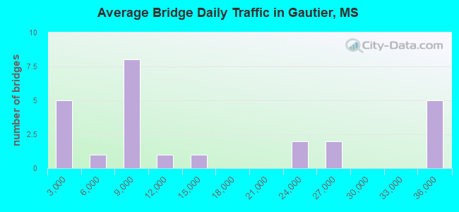
- 363,920Total average daily traffic
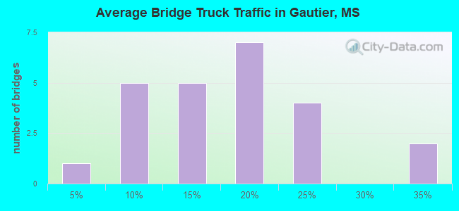
- 54,196Total average daily truck traffic
- National Bridge Inventory (NBI) Registered Bridges for Gautier
- No street view available for this location
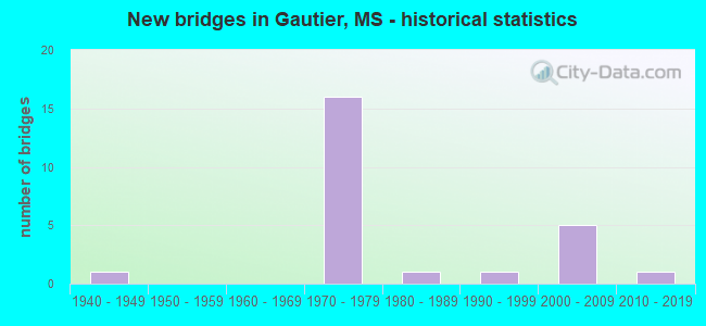
- New bridges - historical statistics
- 11940-1949
- 161970-1979
- 11980-1989
- 11990-1999
- 52000-2009
- 12010-2019
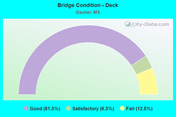
- Bridge Condition - Deck
- 81.3%Good
- 6.3%Satisfactory
- 12.5%Fair
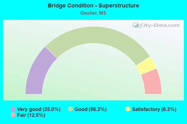
- Bridge Condition - Superstructure
- 25.0%Very good
- 56.3%Good
- 6.3%Satisfactory
- 12.5%Fair
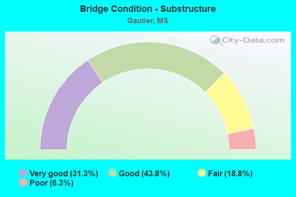
- Bridge Condition - Substructure
- 31.3%Very good
- 43.8%Good
- 18.8%Fair
- 6.3%Poor
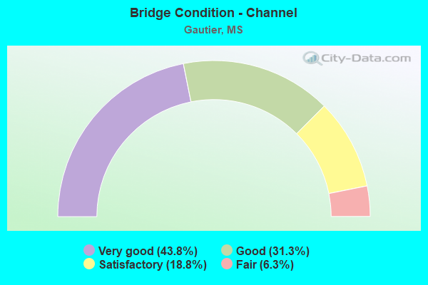
- Bridge Condition - Channel
- 43.8%Very good
- 31.3%Good
- 18.8%Satisfactory
- 6.3%Fair
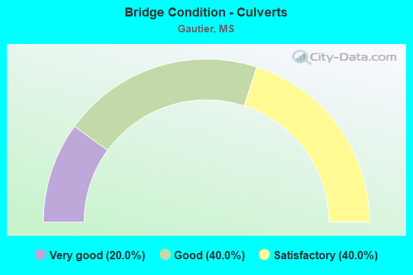
- Bridge Condition - Culverts
- 20.0%Very good
- 40.0%Good
- 40.0%Satisfactory
Find on map >> Show street view
Structure Number: 11000100300590A, Location: 0.3 MI W SR 57 (Lat: 30.443072, Lng: -88.721236), Route carried "on" structure: Interstate 10, Year Built: 1970, Status: Open, Structure Length: 9.75m (31.99ft), Average Daily Traffic: 34,500 (year 2020), Truck Traffic: 15%, Average Future Daily Traffic: 45,500 (year 2040), Design Load: HS 20+Mod, Features Intersected: OLD FORT BAYOU
Minimum Vertical Clearance: 30+ m (98+ ft), Kilometerpoint: 31.870, Lanes on structure: 3, Base Highway Network: Yes (Inventory Route: 1, Subroute: 1), Owner: State Highway Agency, Approaching Roadway Width: 12.8m (42.0ft), Skew: 2 degrees, Material/Design: Prestressed concrete, Design/Construction: Stringer/Multi-beam, Number Of Spans In Main Unit: 1, Number Of Approach Spans: 6, Length of Maximum Span: 24.4m (80.1ft), Curb-To-Curb Width: 14.8m (48.6ft), Out-to-Out Width: 15.8m (51.8ft)
Condition: Deck: Good, Superstructure: Good, Substructure: Fair, Channel: Satisfactory, Operating Rating: 57.2 metric tons, Method Used To Determine Operating Rating: Load Factor (LF), Inventory Rating: 26.8 metric tons, Method Used To Determine Inventory Rating: Load Factor (LF), Structural Evaluation: Somewhat better than minimum adequacy, Deck Geometry: Meets minimum limits, Waterway Adequacy: Equal to present desirable criteria, Approach Roadway Alignment: Equal to present desirable criteria, Designated Inspection Frequency: Every 24 months, Underwater Inspection Frequency: Every 60 months, Inspection Date: November 2021, Underwater Inspection Date: July 2019, Deck Structure Type: Concrete Cast-file-Place
Find on map >> Show street view
Structure Number: 11000100300590B, Location: 0.3 MI W SR 57 (Lat: 30.442967, Lng: -88.722161), Route carried "on" structure: Interstate 10, Year Built: 1970, Status: Open, Structure Length: 9.75m (31.99ft), Average Daily Traffic: 34,500 (year 2020), Truck Traffic: 15%, Average Future Daily Traffic: 45,500 (year 2040), Design Load: HS 20+Mod, Features Intersected: OLD FORT BAYOU
Minimum Vertical Clearance: 30+ m (98+ ft), Kilometerpoint: 15.868, Lanes on structure: 2, Base Highway Network: Yes (Inventory Route: 1, Subroute: 1), Owner: State Highway Agency, Approaching Roadway Width: 12.8m (42.0ft), Skew: 2 degrees, Material/Design: Prestressed concrete, Design/Construction: Stringer/Multi-beam, Number Of Spans In Main Unit: 1, Number Of Approach Spans: 6, Length of Maximum Span: 24.4m (80.1ft), Curb-To-Curb Width: 12.3m (40.4ft), Out-to-Out Width: 13.4m (44.0ft)
Condition: Deck: Good, Superstructure: Very good, Substructure: Fair, Channel: Good, Operating Rating: 59.8 metric tons, Method Used To Determine Operating Rating: Load Factor (LF), Inventory Rating: 30.8 metric tons, Method Used To Determine Inventory Rating: Load Factor (LF), Structural Evaluation: Somewhat better than minimum adequacy, Deck Geometry: Better than present minimum criteria, Waterway Adequacy: Equal to present desirable criteria, Approach Roadway Alignment: Equal to present desirable criteria, Designated Inspection Frequency: Every 24 months, Underwater Inspection Frequency: Every 60 months, Inspection Date: November 2021, Underwater Inspection Date: July 2019, Deck Structure Type: Concrete Cast-file-Place
Find on map >> Show street view
Structure Number: 11000100300593A, Location: I 10 OVER SR 57 (Lat: 30.441528, Lng: -88.716933), Route carried "on" structure: Interstate 10, Year Built: 1970, Status: Open, Structure Length: 10.06m (33.01ft), Average Daily Traffic: 34,500 (year 2020), Truck Traffic: 15%, Average Future Daily Traffic: 45,500 (year 2040), Design Load: HS 20+Mod, Features Intersected: SR 57
Minimum Vertical Clearance: 30+ m (98+ ft), Kilometerpoint: 31.421, Lanes on structure: 2, Lanes under structure: 6, Base Highway Network: Yes (Inventory Route: 1, Subroute: 1), Owner: State Highway Agency, Approaching Roadway Width: 12.8m (42.0ft), Skew: 2 degrees, Material/Design: Prestressed concrete, Design/Construction: Stringer/Multi-beam, Number Of Spans In Main Unit: 2, Number Of Approach Spans: 2, Length of Maximum Span: 27.1m (88.9ft), Curb-To-Curb Width: 12.3m (40.4ft), Out-to-Out Width: 13.4m (44.0ft)
Condition: Deck: Good, Superstructure: Very good, Substructure: Very good, Operating Rating: 60.0 metric tons, Method Used To Determine Operating Rating: Load Factor (LF), Inventory Rating: 24.9 metric tons, Method Used To Determine Inventory Rating: Load Factor (LF), Structural Evaluation: Equal to present minimum criteria, Deck Geometry: Better than present minimum criteria, Underclear: Better than present minimum criteria, Approach Roadway Alignment: Equal to present desirable criteria, Designated Inspection Frequency: Every 24 months, Inspection Date: November 2021, Deck Structure Type: Concrete Cast-file-Place
Find on map >> Show street view
Structure Number: 11000100300593B, Location: I 10 OVER SR 57 (Lat: 30.441414, Lng: -88.717856), Route carried "on" structure: Interstate 10, Year Built: 1970, Status: Open, Structure Length: 10.06m (33.01ft), Average Daily Traffic: 34,500 (year 2020), Truck Traffic: 15%, Average Future Daily Traffic: 45,500 (year 2040), Design Load: HS 20+Mod, Features Intersected: SR 57
Minimum Vertical Clearance: 30+ m (98+ ft), Kilometerpoint: 16.316, Lanes on structure: 2, Lanes under structure: 6, Base Highway Network: Yes (Inventory Route: 1, Subroute: 1), Owner: State Highway Agency, Approaching Roadway Width: 12.8m (42.0ft), Skew: 2 degrees, Material/Design: Prestressed concrete, Design/Construction: Stringer/Multi-beam, Number Of Spans In Main Unit: 2, Number Of Approach Spans: 2, Length of Maximum Span: 27.1m (88.9ft), Curb-To-Curb Width: 12.3m (40.4ft), Out-to-Out Width: 13.4m (44.0ft)
Condition: Deck: Good, Superstructure: Good, Substructure: Very good, Operating Rating: 59.8 metric tons, Method Used To Determine Operating Rating: Load Factor (LF), Inventory Rating: 24.9 metric tons, Method Used To Determine Inventory Rating: Load Factor (LF), Structural Evaluation: Equal to present minimum criteria, Deck Geometry: Better than present minimum criteria, Underclear: Better than present minimum criteria, Approach Roadway Alignment: Equal to present desirable criteria, Designated Inspection Frequency: Every 24 months, Inspection Date: November 2021, Deck Structure Type: Concrete Cast-file-Place
Find on map >> Show street view
Structure Number: 11000100300630A, Location: 3.7 MI E SR 57 (Lat: 30.435125, Lng: -88.655597), Route carried "on" structure: Interstate 10, Year Built: 1977, Status: Open, Structure Length: 9.20m (30.18ft), Average Daily Traffic: 26,500 (year 2020), Truck Traffic: 17%, Average Future Daily Traffic: 35,000 (year 2040), Design Load: HS 20+Mod, Features Intersected: GAUTIER VANCLEAVE ROAD
Minimum Vertical Clearance: 30+ m (98+ ft), Kilometerpoint: 25.307, Lanes on structure: 2, Lanes under structure: 5, Base Highway Network: Yes (Inventory Route: 1, Subroute: 1), Owner: State Highway Agency, Approaching Roadway Width: 12.8m (42.0ft), Skew: 1 degrees, Material/Design: Prestressed concrete, Design/Construction: Stringer/Multi-beam, Number Of Spans In Main Unit: 2, Number Of Approach Spans: 2, Length of Maximum Span: 24.4m (80.1ft), Curb-To-Curb Width: 12.3m (40.4ft), Out-to-Out Width: 13.4m (44.0ft)
Condition: Deck: Good, Superstructure: Good, Substructure: Very good, Operating Rating: 64.1 metric tons, Method Used To Determine Operating Rating: Load Factor (LF), Inventory Rating: 33.5 metric tons, Method Used To Determine Inventory Rating: Load Factor (LF), Structural Evaluation: Better than present minimum criteria, Deck Geometry: Better than present minimum criteria, Underclear: Better than present minimum criteria, Approach Roadway Alignment: Equal to present desirable criteria, Designated Inspection Frequency: Every 24 months, Inspection Date: November 2021, Deck Structure Type: Concrete Cast-file-Place
Find on map >> Show street view
Structure Number: 11000100300630B, Location: 3.7 MI E SR 57 (Lat: 30.434622, Lng: -88.656364), Route carried "on" structure: Interstate 10, Year Built: 1977, Status: Open, Structure Length: 9.20m (30.18ft), Average Daily Traffic: 26,500 (year 2020), Truck Traffic: 18%, Average Future Daily Traffic: 35,000 (year 2040), Design Load: HS 20+Mod, Features Intersected: GAUTIER VANCLEAVE ROAD
Minimum Vertical Clearance: 30+ m (98+ ft), Kilometerpoint: 22.450, Lanes on structure: 2, Lanes under structure: 5, Base Highway Network: Yes (Inventory Route: 1, Subroute: 1), Owner: State Highway Agency, Approaching Roadway Width: 12.8m (42.0ft), Skew: 1 degrees, Material/Design: Prestressed concrete, Design/Construction: Stringer/Multi-beam, Number Of Spans In Main Unit: 2, Number Of Approach Spans: 2, Length of Maximum Span: 24.4m (80.1ft), Curb-To-Curb Width: 12.3m (40.4ft), Out-to-Out Width: 13.4m (44.0ft)
Condition: Deck: Good, Superstructure: Good, Substructure: Very good, Operating Rating: 64.1 metric tons, Method Used To Determine Operating Rating: Load Factor (LF), Inventory Rating: 33.5 metric tons, Method Used To Determine Inventory Rating: Load Factor (LF), Structural Evaluation: Better than present minimum criteria, Deck Geometry: Better than present minimum criteria, Underclear: Better than present minimum criteria, Approach Roadway Alignment: Equal to present desirable criteria, Designated Inspection Frequency: Every 24 months, Inspection Date: November 2021, Deck Structure Type: Concrete Cast-file-Place
Find on map >> Show street view
Structure Number: 11000100300646B, Location: 5.3 MI E SR 57 (Lat: 30.437211, Lng: -88.631350), Route carried "on" structure: Interstate 10, Year Built: 1977, Status: Open, Structure Length: 6.52m (21.39ft), Average Daily Traffic: 23,500 (year 2020), Truck Traffic: 24%, Average Future Daily Traffic: 27,000 (year 2040), Design Load: HS 20+Mod, Features Intersected: MARTIN BLUFF ROAD
Minimum Vertical Clearance: 30+ m (98+ ft), Kilometerpoint: 24.871, Lanes on structure: 2, Lanes under structure: 2, Base Highway Network: Yes (Inventory Route: 1, Subroute: 1), Owner: State Highway Agency, Approaching Roadway Width: 12.8m (42.0ft), Material/Design: Prestressed concrete, Design/Construction: Stringer/Multi-beam, Number Of Spans In Main Unit: 1, Number Of Approach Spans: 2, Length of Maximum Span: 26.8m (87.9ft), Curb-To-Curb Width: 12.3m (40.4ft), Out-to-Out Width: 13.4m (44.0ft)
Condition: Deck: Good, Superstructure: Very good, Substructure: Very good, Operating Rating: 59.7 metric tons, Method Used To Determine Operating Rating: Load Factor (LF), Inventory Rating: 25.9 metric tons, Method Used To Determine Inventory Rating: Load Factor (LF), Structural Evaluation: Equal to present minimum criteria, Deck Geometry: Better than present minimum criteria, Underclear: Superior to present desirable criteria, Approach Roadway Alignment: Equal to present desirable criteria, Designated Inspection Frequency: Every 24 months, Inspection Date: November 2021, Deck Structure Type: Concrete Cast-file-Place
Find on map >> Show street view
Structure Number: 11000100300654B, Location: 4.4 MI W SR 613 (Lat: 30.437575, Lng: -88.616678), Route carried "on" structure: Interstate 10, Year Built: 1976, Status: Open, Structure Length: 637.92m (2092.91ft), Average Daily Traffic: 23,500 (year 2020), Truck Traffic: 24%, Average Future Daily Traffic: 31,500 (year 2040), Design Load: HS 20+Mod, Features Intersected: PASCAGOULA RIVER
Minimum Vertical Clearance: 30+ m (98+ ft), Kilometerpoint: 26.281, Lanes on structure: 2, Base Highway Network: Yes (Inventory Route: 1, Subroute: 1), Owner: State Highway Agency, Approaching Roadway Width: 13.4m (44.0ft), Navigation Control: Yes ( Vertical Clearance: 13.0m (42.7ft), Horizontal Clearance: 82.0m (269.0ft)), Material/Design: Steel, Design/Construction: Box Beam or Girders - Multiple, Number Of Spans In Main Unit: 1, Number Of Approach Spans: 329, Length of Maximum Span: 106.7m (350.1ft), Curb-To-Curb Width: 12.3m (40.4ft), Out-to-Out Width: 13.4m (44.0ft)
Condition: Deck: Good, Superstructure: Satisfactory, Substructure: Good, Channel: Good, Operating Rating: 52.5 metric tons, Method Used To Determine Operating Rating: Load Factor (LF), Inventory Rating: 25.5 metric tons, Method Used To Determine Inventory Rating: Load Factor (LF), Structural Evaluation: Equal to present minimum criteria, Deck Geometry: Better than present minimum criteria, Waterway Adequacy: Equal to present minimum criteria, Approach Roadway Alignment: Equal to present desirable criteria, Designated Inspection Frequency: Every 24 months, Critical Feature Inspection Frequency: Every 12 months, Underwater Inspection Frequency: Every 60 months, Inspection Date: September 2020, Critical Feature Inspection Date: September 2021, Underwater Inspection Date: March 2019, Deck Structure Type: Concrete Cast-file-Place
Find on map >> Show street view
Structure Number: 21000900300656, Location: 6.6 MI E SR 57 (Lat: 30.383242, Lng: -88.610436), Route carried "on" structure: US 90, Year Built: 2002, Status: Open, Structure Length: 55.60m (182.41ft), Average Daily Traffic: 35,000 (year 2020), Truck Traffic: 3%, Average Future Daily Traffic: 35,000 (year 2040), Design Load: HS 20, Features Intersected: WEST PASCAGOULA RIVER
Minimum Vertical Clearance: 30+ m (98+ ft), Kilometerpoint: 22.705, Lanes on structure: 6, Base Highway Network: Yes (Inventory Route: 9, Subroute: 1), Owner: State Highway Agency, Approaching Roadway Width: 33.8m (110.9ft), Skew: 30 degrees, Material/Design: Prestressed concrete, Design/Construction: Stringer/Multi-beam, Number Of Spans In Main Unit: 3, Number Of Approach Spans: 38, Length of Maximum Span: 30.8m (101.0ft), Curb-To-Curb Width: 34.4m (112.9ft), Out-to-Out Width: 35.9m (117.8ft)
Condition: Deck: Good, Superstructure: Very good, Substructure: Fair, Channel: Good, Operating Rating: 57.6 metric tons, Method Used To Determine Operating Rating: Load Factor (LF), Inventory Rating: 34.6 metric tons, Method Used To Determine Inventory Rating: Load Factor (LF), Structural Evaluation: Somewhat better than minimum adequacy, Deck Geometry: Superior to present desirable criteria, Waterway Adequacy: Equal to present minimum criteria, Approach Roadway Alignment: Equal to present desirable criteria, Designated Inspection Frequency: Every 24 months, Underwater Inspection Frequency: Every 60 months, Inspection Date: August 2020, Underwater Inspection Date: May 2019, Deck Structure Type: Concrete Cast-file-Place
Find on map >> Show street view
Structure Number: 3100057030003, Location: 1.7 MI N I 10 (Lat: 30.465658, Lng: -88.719261), Route carried "on" structure: State highway 57, Year Built: 1947, Status: Open, Structure Length: 1.13m (3.71ft), Average Daily Traffic: 6,800 (year 2020), Truck Traffic: 8%, Average Future Daily Traffic: 7,400 (year 2040), Design Load: HS 20, Features Intersected: OLD FORT BAYOU TRIBUTARY
Minimum Vertical Clearance: 30+ m (98+ ft), Kilometerpoint: 7.133, Lanes on structure: 2, Base Highway Network: Yes (Inventory Route: 5, Subroute: 1), Owner: State Highway Agency, Approaching Roadway Width: 12.2m (40.0ft), Material/Design: Concrete, Design/Construction: Culvert, Number Of Spans In Main Unit: 6, Length of Maximum Span: 1.4m (4.6ft)
Condition: Channel: Good, Culverts: Good, Operating Rating: 40.0 metric tons, Method Used To Determine Operating Rating: Load Factor (LF), Inventory Rating: 32.4 metric tons, Method Used To Determine Inventory Rating: Load Factor (LF), Structural Evaluation: Better than present minimum criteria, Waterway Adequacy: Somewhat better than minimum adequacy, Approach Roadway Alignment: Equal to present desirable criteria, Designated Inspection Frequency: Every 24 months, Inspection Date: August 2021
Find on map >> Show street view
Structure Number: SA3000000000078, Location: SEC 35 T 6S R 8W B (Lat: 30.484444, Lng: -88.749722), Route carried "on" structure: County highway 2107, Year Built: 1995, Status: Open, Structure Length: 4.42m (14.50ft), Average Daily Traffic: 1,400 (year 2021), Truck Traffic: 10%, Average Future Daily Traffic: 2,500 (year 2041), Design Load: HS 20, Features Intersected: BAYOU PERIGAL, Facility Carried by Structure: OLD FORT BAYOU RD
Minimum Vertical Clearance: 30+ m (98+ ft), Kilometerpoint: 10.943, Lanes on structure: 2, Owner: County Highway Agency, Approaching Roadway Width: 7.6m (24.9ft), Material/Design: Concrete, Design/Construction: Slab, Number Of Spans In Main Unit: 7, Length of Maximum Span: 9.4m (30.8ft), Curb-To-Curb Width: 8.2m (26.9ft), Out-to-Out Width: 8.6m (28.2ft)
Condition: Deck: Good, Superstructure: Good, Substructure: Good, Channel: Very good, Operating Rating: 75.8 metric tons, Method Used To Determine Operating Rating: Load Factor (LF), Inventory Rating: 45.4 metric tons, Method Used To Determine Inventory Rating: Load Factor (LF), Structural Evaluation: Better than present minimum criteria, Deck Geometry: Meets minimum limits, Waterway Adequacy: Equal to present desirable criteria, Approach Roadway Alignment: Equal to present minimum criteria, Designated Inspection Frequency: Every 24 months, Inspection Date: Febuary 2021, Deck Structure Type: Concrete Cast-file-Place, Wearing Surface/Protective System: Wearing Surface: Monolithic Concrete
Find on map >> Show street view
Structure Number: SA3000000000108, Location: SEC 10 T 7S R 7W B (Lat: 30.448789, Lng: -88.666667), Route carried "on" structure: County highway 1140, Year Built: 1975, Status: Open, Structure Length: 0.64m (2.10ft), Average Daily Traffic: 5,900 (year 2021), Truck Traffic: 10%, Average Future Daily Traffic: 6,600 (year 2041), Design Load: HS 20, Features Intersected: RELIEF, Facility Carried by Structure: GAUTIER-VANCLEAVE
Minimum Vertical Clearance: 30+ m (98+ ft), Kilometerpoint: 7.402, Lanes on structure: 2, Owner: County Highway Agency, Approaching Roadway Width: 11.6m (38.1ft), Material/Design: Concrete, Design/Construction: Culvert, Number Of Spans In Main Unit: 1, Length of Maximum Span: 6.4m (21.0ft), Curb-To-Curb Width: 13.3m (43.6ft), Out-to-Out Width: 13.3m (43.6ft)
Condition: Channel: Very good, Culverts: Very good, Operating Rating: 67.3 metric tons, Method Used To Determine Operating Rating: Load Factor (LF), Inventory Rating: 40.5 metric tons, Method Used To Determine Inventory Rating: Load Factor (LF), Structural Evaluation: Equal to present desirable criteria, Deck Geometry: Somewhat better than minimum adequacy, Waterway Adequacy: Equal to present desirable criteria, Approach Roadway Alignment: Equal to present desirable criteria, Designated Inspection Frequency: Every 24 months, Inspection Date: November 2021
Find on map >> Show street view
Structure Number: SA300000000011, Location: SEC 23 T 7S R 7W B (Lat: 30.419675, Lng: -88.649581), Route carried "on" structure: County highway 1140, Year Built: 1975, Status: Open, Structure Length: 0.79m (2.59ft), Average Daily Traffic: 14,000 (year 2021), Truck Traffic: 15%, Average Future Daily Traffic: 15,400 (year 2041), Design Load: HS 20, Features Intersected: SIOUX BAYOU, Facility Carried by Structure: GAUTIER-VANCLEAVE
Minimum Vertical Clearance: 30+ m (98+ ft), Kilometerpoint: 3.379, Lanes on structure: 4, Owner: County Highway Agency, Approaching Roadway Width: 18.9m (62.0ft), Material/Design: Concrete, Design/Construction: Culvert, Number Of Spans In Main Unit: 2, Length of Maximum Span: 4.0m (13.1ft), Curb-To-Curb Width: 17.7m (58.1ft), Out-to-Out Width: 22.6m (74.1ft)
Condition: Channel: Satisfactory, Culverts: Satisfactory, Operating Rating: 32.6 metric tons, Method Used To Determine Operating Rating: Field evaluation and documented engineering judgment, Inventory Rating: 21.8 metric tons, Method Used To Determine Inventory Rating: Field evaluation and documented engineering judgment, Structural Evaluation: Somewhat better than minimum adequacy, Deck Geometry: Somewhat better than minimum adequacy, Waterway Adequacy: Equal to present desirable criteria, Approach Roadway Alignment: Better than present minimum criteria, Designated Inspection Frequency: Every 24 months, Inspection Date: November 2021
Find on map >> Show street view
Structure Number: SA3000000000112, Location: SEC 26 T 7S R 7W B (Lat: 30.410558, Lng: -88.655211), Route carried "on" structure: County highway 1140, Year Built: 1975, Status: Open, Structure Length: 0.67m (2.20ft), Average Daily Traffic: 6,000 (year 2021), Truck Traffic: 30%, Average Future Daily Traffic: 6,600 (year 2041), Design Load: HS 20, Features Intersected: MARY WALKER BAYOU, Facility Carried by Structure: GAUTIER-VANCLEAVE
Minimum Vertical Clearance: 30+ m (98+ ft), Kilometerpoint: 2.253, Lanes on structure: 5, Owner: County Highway Agency, Approaching Roadway Width: 17.9m (58.7ft), Skew: 1 degrees, Material/Design: Concrete, Design/Construction: Culvert, Number Of Spans In Main Unit: 2, Length of Maximum Span: 3.4m (11.2ft), Curb or Sidewalk Widths: Left: 0.0m, Right: 1.7m (5.6ft)
Condition: Channel: Fair, Culverts: Satisfactory, Operating Rating: 32.6 metric tons, Method Used To Determine Operating Rating: Field evaluation and documented engineering judgment, Inventory Rating: 21.8 metric tons, Method Used To Determine Inventory Rating: Field evaluation and documented engineering judgment, Structural Evaluation: Somewhat better than minimum adequacy, Waterway Adequacy: Equal to present desirable criteria, Approach Roadway Alignment: Better than present minimum criteria, Designated Inspection Frequency: Every 24 months, Inspection Date: November 2021
Find on map >> Show street view
Structure Number: SA3000000000113, Location: SEC 35 T 7S R 7W B (Lat: 30.397836, Lng: -88.652703), Route carried "on" structure: County highway 1140, Year Built: 1975, Status: Open, Structure Length: 0.70m (2.30ft), Average Daily Traffic: 10,950 (year 2021), Truck Traffic: 30%, Average Future Daily Traffic: 12,045 (year 2041), Design Load: HS 20, Features Intersected: DRAIN, Facility Carried by Structure: GAUTIER-VANCLEAVE
Minimum Vertical Clearance: 30+ m (98+ ft), Kilometerpoint: 0.643, Lanes on structure: 4, Owner: County Highway Agency, Approaching Roadway Width: 19.5m (64.0ft), Skew: 1 degrees, Material/Design: Concrete, Design/Construction: Culvert, Number Of Spans In Main Unit: 2, Length of Maximum Span: 3.7m (12.1ft), Curb-To-Curb Width: 18.3m (60.0ft), Out-to-Out Width: 18.3m (60.0ft)
Condition: Channel: Satisfactory, Culverts: Good, Operating Rating: 32.6 metric tons, Method Used To Determine Operating Rating: Field evaluation and documented engineering judgment, Inventory Rating: 21.8 metric tons, Method Used To Determine Inventory Rating: Field evaluation and documented engineering judgment, Structural Evaluation: Somewhat better than minimum adequacy, Deck Geometry: Somewhat better than minimum adequacy, Waterway Adequacy: Equal to present desirable criteria, Approach Roadway Alignment: Equal to present desirable criteria, Designated Inspection Frequency: Every 24 months, Inspection Date: November 2021
Find on map >> Show street view
Structure Number: SA3000000000143, Location: SEC 4 T 8S R 6W (Lat: 30.369008, Lng: -88.629753), Route carried "on" structure: County highway 154, Year Built: 1987, Status: Posted for load, Structure Length: 2.32m (7.61ft), Average Daily Traffic: 1,700 (year 2020), Truck Traffic: 20%, Average Future Daily Traffic: 1,870 (year 2040), Design Load: H 15, Features Intersected: BAYOU LAMOTT, Facility Carried by Structure: GRAVELINE ROAD
Minimum Vertical Clearance: 30+ m (98+ ft), Kilometerpoint: 3.218, Lanes on structure: 2, Owner: County Highway Agency, Approaching Roadway Width: 7.6m (24.9ft), Material/Design: Concrete, Design/Construction: Channel Beam, Number Of Spans In Main Unit: 4, Length of Maximum Span: 5.8m (19.0ft), Curb or Sidewalk Widths: Left: 0.2m (0.7ft), Right: 0.2m (0.7ft), Curb-To-Curb Width: 7.1m (23.3ft), Out-to-Out Width: 7.5m (24.6ft)
Condition: Deck: Fair, Superstructure: Fair, Substructure: Poor, Channel: Very good, Operating Rating: 13.6 metric tons, Method Used To Determine Operating Rating: Load Factor (LF) rating reported by rating factor (RF) method using MS18 loading, Inventory Rating: 8.1 metric tons, Method Used To Determine Inventory Rating: Load Factor (LF) rating reported by rating factor (RF) method using MS18 loading, Structural Evaluation: High priority of replacement, Deck Geometry: High priority of corrective action, Waterway Adequacy: Equal to present desirable criteria, Approach Roadway Alignment: Equal to present minimum criteria, Bridge Posting: Required (Relationship of Operating Rating to Maximum Legal Load: > 39.9% below), Length Of Structure Improvement: 2.32m (7.61ft), Designated Inspection Frequency: Every 12 months, Inspection Date: December 2020, Bridge Improvement Cost: $76,000, Roadway Improvement Cost: $10,000, Total Project Cost: $130,000, Deck Structure Type: Concrete Precast Panels
Find on map >> Show street view
Structure Number: SA300000000015, Location: SEC 9 T 8S R 6W (Lat: 30.376111, Lng: -88.614444), Route carried "on" structure: County highway 107, Year Built: 2003, Status: Open, Structure Length: 3.26m (10.70ft), Average Daily Traffic: 1,400 (year 2021), Truck Traffic: 20%, Average Future Daily Traffic: 2,000 (year 2041), Design Load: HS 20, Features Intersected: BAYOU PIERRE, Facility Carried by Structure: GRAVELINE ROAD
Minimum Vertical Clearance: 30+ m (98+ ft), Kilometerpoint: 0.160, Lanes on structure: 2, Owner: County Highway Agency, Approaching Roadway Width: 10.4m (34.1ft), Material/Design: Concrete, Design/Construction: Channel Beam, Number Of Spans In Main Unit: 5, Length of Maximum Span: 9.4m (30.8ft), Curb-To-Curb Width: 10.4m (34.1ft), Out-to-Out Width: 11.0m (36.1ft)
Condition: Deck: Good, Superstructure: Good, Substructure: Good, Channel: Very good, Operating Rating: 59.8 metric tons, Method Used To Determine Operating Rating: Load Factor (LF), Inventory Rating: 36.0 metric tons, Method Used To Determine Inventory Rating: Load Factor (LF), Structural Evaluation: Better than present minimum criteria, Deck Geometry: Equal to present minimum criteria, Waterway Adequacy: Equal to present desirable criteria, Approach Roadway Alignment: Equal to present minimum criteria, Designated Inspection Frequency: Every 24 months, Inspection Date: November 2021, Deck Structure Type: Concrete Precast Panels
Find on map >> Show street view
Structure Number: SA3000000000173, Location: SEC 8 T 8S R 7W (Lat: 30.360814, Lng: -88.714294), Route carried "on" structure: County highway , Year Built: 2000, Status: Open, Structure Length: 1.16m (3.81ft), Average Daily Traffic: 150 (year 2020), Average Future Daily Traffic: 165 (year 2040), Design Load: H 20, Features Intersected: BRANCH TO GRAVELINE BAY, Facility Carried by Structure: SPRUCE ST.
Minimum Vertical Clearance: 30+ m (98+ ft), Kilometerpoint: 0.400, Lanes on structure: 2, Owner: County Highway Agency, Approaching Roadway Width: 7.1m (23.3ft), Material/Design: Concrete, Design/Construction: Channel Beam, Number Of Spans In Main Unit: 2, Length of Maximum Span: 5.8m (19.0ft), Curb or Sidewalk Widths: Left: 0.2m (0.7ft), Right: 0.2m (0.7ft), Curb-To-Curb Width: 7.1m (23.3ft), Out-to-Out Width: 7.5m (24.6ft)
Condition: Deck: Fair, Superstructure: Fair, Substructure: Good, Channel: Good, Operating Rating: 65.1 metric tons, Method Used To Determine Operating Rating: Load Factor (LF) rating reported by rating factor (RF) method using MS18 loading, Inventory Rating: 38.9 metric tons, Method Used To Determine Inventory Rating: Load Factor (LF) rating reported by rating factor (RF) method using MS18 loading, Structural Evaluation: Somewhat better than minimum adequacy, Deck Geometry: Meets minimum limits, Waterway Adequacy: Better than present minimum criteria, Approach Roadway Alignment: Equal to present desirable criteria, Designated Inspection Frequency: Every 24 months, Inspection Date: May 2020, Deck Structure Type: Concrete Precast Panels, Wearing Surface/Protective System: Wearing Surface: Monolithic Concrete
Find on map >> Show street view
Structure Number: SA3000000000188, Location: SEC 18 T 7S R 7W B (Lat: 30.438250, Lng: -88.727222), Route carried "on" structure: County highway 9065, Year Built: 2005, Status: Open, Structure Length: 1.74m (5.71ft), Average Daily Traffic: 7,500 (year 2021), Truck Traffic: 10%, Average Future Daily Traffic: 10,000 (year 2041), Design Load: HS 20, Features Intersected: DRAIN TO OLD FORT BAYOU, Facility Carried by Structure: OCEAN SPRING ROAD
Minimum Vertical Clearance: 30+ m (98+ ft), Kilometerpoint: 1.300, Lanes on structure: 2, Owner: County Highway Agency, Approaching Roadway Width: 8.6m (28.2ft), Material/Design: Concrete, Design/Construction: Channel Beam, Number Of Spans In Main Unit: 3, Length of Maximum Span: 5.8m (19.0ft), Curb-To-Curb Width: 8.6m (28.2ft), Out-to-Out Width: 9.4m (30.8ft)
Condition: Deck: Good, Superstructure: Good, Substructure: Good, Channel: Very good, Operating Rating: 89.2 metric tons, Method Used To Determine Operating Rating: Load Factor (LF), Inventory Rating: 53.6 metric tons, Method Used To Determine Inventory Rating: Load Factor (LF), Structural Evaluation: Better than present minimum criteria, Deck Geometry: High priority of replacement, Waterway Adequacy: Equal to present desirable criteria, Approach Roadway Alignment: Equal to present desirable criteria, Length Of Structure Improvement: 2.10m (6.89ft), Designated Inspection Frequency: Every 24 months, Inspection Date: December 2021, Bridge Improvement Cost: $500,000, Roadway Improvement Cost: $150,000, Total Project Cost: $800,000 ( Estimate for 2021), Deck Structure Type: Concrete Precast Panels
Find on map >> Show street view
Structure Number: SA3000000000191, Location: SEC 6 T 8S R 7W (Lat: 30.370583, Lng: -88.719306), Route carried "on" structure: County highway 1149, Year Built: 2004, Status: Open, Structure Length: 68.98m (226.31ft), Average Daily Traffic: 6,000 (year 2020), Truck Traffic: 10%, Average Future Daily Traffic: 8,000 (year 2040), Design Load: HS 20, Features Intersected: GRAVELINE BAY, Facility Carried by Structure: ERNEST APPLEWHITE
Minimum Vertical Clearance: 30+ m (98+ ft), Kilometerpoint: 0.000, Lanes on structure: 2, Owner: County Highway Agency, Approaching Roadway Width: 8.6m (28.2ft), Material/Design: Concrete, Design/Construction: Channel Beam, Number Of Spans In Main Unit: 73, Length of Maximum Span: 9.4m (30.8ft), Curb-To-Curb Width: 8.6m (28.2ft), Out-to-Out Width: 9.4m (30.8ft)
Condition: Deck: Satisfactory, Superstructure: Good, Substructure: Good, Channel: Very good, Operating Rating: 63.1 metric tons, Method Used To Determine Operating Rating: Load Factor (LF), Inventory Rating: 37.9 metric tons, Method Used To Determine Inventory Rating: Load Factor (LF), Structural Evaluation: Better than present minimum criteria, Deck Geometry: Meets minimum limits, Waterway Adequacy: Equal to present desirable criteria, Approach Roadway Alignment: Equal to present desirable criteria, Designated Inspection Frequency: Every 24 months, Inspection Date: March 2020, Deck Structure Type: Concrete Precast Panels
Find on map >> Show street view
Structure Number: SA3000000000202, Location: SEC 14 T 8S R 7W (Lat: 30.363922, Lng: -88.650597), Route carried "on" structure: City street , Year Built: 2010, Status: Open, Structure Length: 2.83m (9.28ft), Average Daily Traffic: 120 (year 2021), Truck Traffic: 10%, Average Future Daily Traffic: 200 (year 2041), Design Load: HS 20, Features Intersected: BAYOU RELIEF, Facility Carried by Structure: ROBERT HIRAM DRIVE
Minimum Vertical Clearance: 30+ m (98+ ft), Kilometerpoint: 3530.000, Lanes on structure: 2, Owner: City or Municipal Highway Agency, Approaching Roadway Width: 85.0m (278.9ft), Material/Design: Concrete, Design/Construction: Channel Beam, Number Of Spans In Main Unit: 3, Length of Maximum Span: 9.4m (30.8ft), Curb or Sidewalk Widths: Left: 2.0m (6.6ft), Right: 2.0m (6.6ft), Curb-To-Curb Width: 81.0m (265.7ft), Out-to-Out Width: 85.0m (278.9ft)
Condition: Deck: Good, Superstructure: Good, Substructure: Good, Channel: Very good, Operating Rating: 93.4 metric tons, Method Used To Determine Operating Rating: Load Factor (LF), Inventory Rating: 55.9 metric tons, Method Used To Determine Inventory Rating: Load Factor (LF), Structural Evaluation: Better than present minimum criteria, Deck Geometry: Superior to present desirable criteria, Waterway Adequacy: Equal to present desirable criteria, Approach Roadway Alignment: Equal to present desirable criteria, Designated Inspection Frequency: Every 24 months, Inspection Date: Febuary 2021, Deck Structure Type: Concrete Precast Panels
Find on map >> Show street view
Structure Number: 11000100300593A, Location: I 10 OVER SR 57 (Lat: 30.441739, Lng: -88.717531), Route carried "under" structure: State highway 57, Year Built: 1970, Structure Length: 0. m, Average Daily Traffic: 6,500 (year 2018), Truck Traffic: 5%, Features Intersected: SR 57, Facility Carried by Structure: I 10
Minimum Vertical Clearance: 4.94m (16.21ft), Kilometerpoint: 0.447, Lanes on structure: 2, Lanes under structure: 4, Material/Design: Prestressed concrete, Design/Construction: Stringer/Multi-beam, Length of Maximum Span: 27.1m (88.9ft)
Find on map >> Show street view
Structure Number: 11000100300593A, Location: I 10 OVER SR 57 (Lat: 30.441661, Lng: -88.717311), Route carried "under" structure: State highway 57, Year Built: 1970, Structure Length: 0. m, Average Daily Traffic: 6,500 (year 2018), Truck Traffic: 5%, Features Intersected: SR 57, Facility Carried by Structure: I 10
Minimum Vertical Clearance: 4.94m (16.21ft), Kilometerpoint: 4.464, Lanes on structure: 4, Lanes under structure: 4, Material/Design: Prestressed concrete, Design/Construction: Stringer/Multi-beam, Length of Maximum Span: 27.1m (88.9ft)
Find on map >> Show street view
Structure Number: 11000100300593B, Location: I 10 OVER SR 57 (Lat: 30.441281, Lng: -88.717481), Route carried "under" structure: State highway 57, Year Built: 1970, Structure Length: 0. m, Average Daily Traffic: 8,000 (year 2018), Truck Traffic: 5%, Features Intersected: SR 57, Facility Carried by Structure: I 10
Minimum Vertical Clearance: 4.87m (15.98ft), Kilometerpoint: 0.499, Lanes on structure: 2, Lanes under structure: 4, Material/Design: Prestressed concrete, Design/Construction: Stringer/Multi-beam, Length of Maximum Span: 27.1m (88.9ft)
Find on map >> Show street view
Structure Number: 11000100300593B, Location: I 10 OVER SR 57 (Lat: 30.441200, Lng: -88.717261), Route carried "under" structure: State highway 57, Year Built: 1970, Structure Length: 0. m, Average Daily Traffic: 8,000 (year 2018), Truck Traffic: 5%, Features Intersected: SR 57, Facility Carried by Structure: I 10
Minimum Vertical Clearance: 4.84m (15.88ft), Kilometerpoint: 4.413, Lanes on structure: 4, Lanes under structure: 4, Material/Design: Prestressed concrete, Design/Construction: Stringer/Multi-beam, Length of Maximum Span: 27.1m (88.9ft)