Bridge Statistics for Gays, Illinois (IL)
Condition, Traffic, Stress, Structural Evaluation, Project Costs
- National Bridge Inventory (NBI) Statistics
- 12Number of bridges
- 59ft / 17.8mTotal length
- $523,000Total costs
- 2,000Total average daily traffic
- 260Total average daily truck traffic
- 2,391Total future (year 2032) average daily traffic
- National Bridge Inventory (NBI) Registered Bridges for Gays
- No street view available for this location
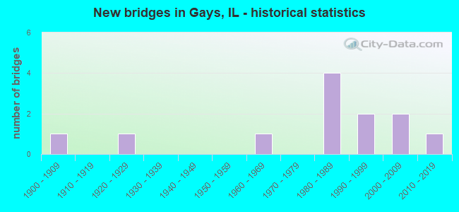
- New bridges - historical statistics
- 11900-1909
- 11920-1929
- 11960-1969
- 41980-1989
- 21990-1999
- 22000-2009
- 12010-2019


- Bridge Condition - Deck
- 66.7%Very good
- 11.1%Good
- 22.2%Fair

- Bridge Condition - Superstructure
- 66.7%Very good
- 11.1%Good
- 22.2%Fair

- Bridge Condition - Substructure
- 44.4%Very good
- 22.2%Good
- 11.1%Satisfactory
- 22.2%Fair

- Bridge Condition - Channel
- 16.7%Excellent
- 8.3%Very good
- 41.7%Satisfactory
- 33.3%Fair

- Bridge Condition - Culverts
- 33.3%Good
- 66.7%Satisfactory
Find on map >> Show street view
Structure Number: 153297, Location: 1 MI W LAKE PARADISE (Lat: 39.410378, Lng: -88.462992), Route carried "on" structure: County highway , Year Built: 1987, Status: Open, Structure Length: 1.36m (4.46ft), Average Daily Traffic: 250 (year 2019), Truck Traffic: 4%, Average Future Daily Traffic: 384 (year 2032), Design Load: HS 20, Features Intersected: CLEAR CREEK, Facility Carried by Structure: TR 247 A
Minimum Vertical Clearance: 30+ m (98+ ft), Kilometerpoint: 0.644, Lanes on structure: 2, Owner: Town or Township Highway Agency, Approaching Roadway Width: 5.5m (18.0ft), Skew: 2 degrees, Material/Design: Prestressed concrete, Design/Construction: Box Beam or Girders - Multiple, Number Of Spans In Main Unit: 1, Length of Maximum Span: 13.2m (43.3ft), Curb-To-Curb Width: 7.3m (24.0ft), Out-to-Out Width: 7.3m (24.0ft)
Condition: Deck: Good, Superstructure: Good, Substructure: Fair, Channel: Fair, Operating Rating: 44.4 metric tons, Method Used To Determine Operating Rating: Assigned rating based on Load Factor Design (LFD) reported by rating factor (RF) using MS18 loading, Inventory Rating: 32.4 metric tons, Method Used To Determine Inventory Rating: Assigned rating based on Load Factor Design (LFD) reported by rating factor (RF) using MS18 loading, Structural Evaluation: Somewhat better than minimum adequacy, Deck Geometry: Somewhat better than minimum adequacy, Waterway Adequacy: Better than present minimum criteria, Approach Roadway Alignment: Equal to present desirable criteria, Designated Inspection Frequency: Every 24 months, Inspection Date: December 2021, Deck Structure Type: Concrete Precast Panels, Wearing Surface/Protective System: Wearing Surface: Gravel
Find on map >> Show street view
Structure Number: 153306, Location: 1.25 MI S COLES STA (Lat: 39.503494, Lng: -88.470889), Route carried "on" structure: County highway , Year Built: 1993, Status: Open, Structure Length: 1.53m (5.02ft), Average Daily Traffic: 275 (year 2019), Truck Traffic: 15%, Average Future Daily Traffic: 205 (year 2032), Design Load: HS 20, Features Intersected: WHITLEY CREEK, Facility Carried by Structure: TR 4
Minimum Vertical Clearance: 30+ m (98+ ft), Kilometerpoint: 5.005, Lanes on structure: 2, Owner: Town or Township Highway Agency, Approaching Roadway Width: 6.1m (20.0ft), Material/Design: Prestressed concrete, Design/Construction: Box Beam or Girders - Multiple, Number Of Spans In Main Unit: 1, Length of Maximum Span: 14.9m (48.9ft), Curb-To-Curb Width: 8.2m (26.9ft), Out-to-Out Width: 8.2m (26.9ft)
Condition: Deck: Very good, Superstructure: Very good, Substructure: Good, Channel: Fair, Operating Rating: 44.1 metric tons, Method Used To Determine Operating Rating: Assigned rating based on Load Factor Design (LFD) reported by rating factor (RF) using MS18 loading, Inventory Rating: 32.4 metric tons, Method Used To Determine Inventory Rating: Assigned rating based on Load Factor Design (LFD) reported by rating factor (RF) using MS18 loading, Structural Evaluation: Better than present minimum criteria, Deck Geometry: Somewhat better than minimum adequacy, Waterway Adequacy: Equal to present desirable criteria, Approach Roadway Alignment: Equal to present desirable criteria, Designated Inspection Frequency: Every 48 months, Inspection Date: December 2020, Deck Structure Type: Concrete Precast Panels
Find on map >> Show street view
Structure Number: 153363, Location: 1 MI S OF COLES STA (Lat: 39.506667, Lng: -88.470917), Route carried "on" structure: County highway , Year Built: 1994, Status: Open, Structure Length: 1.57m (5.15ft), Average Daily Traffic: 300 (year 2019), Truck Traffic: 13%, Average Future Daily Traffic: 307 (year 2032), Design Load: HS 20, Features Intersected: WHITLEY CREEK, Facility Carried by Structure: TR 4
Minimum Vertical Clearance: 30+ m (98+ ft), Kilometerpoint: 4.651, Lanes on structure: 2, Owner: Town or Township Highway Agency, Approaching Roadway Width: 5.5m (18.0ft), Material/Design: Prestressed concrete, Design/Construction: Box Beam or Girders - Multiple, Number Of Spans In Main Unit: 1, Length of Maximum Span: 15.3m (50.2ft), Curb-To-Curb Width: 8.2m (26.9ft), Out-to-Out Width: 8.2m (26.9ft)
Condition: Deck: Very good, Superstructure: Very good, Substructure: Good, Channel: Satisfactory, Operating Rating: 44.1 metric tons, Method Used To Determine Operating Rating: Assigned rating based on Load Factor Design (LFD) reported by rating factor (RF) using MS18 loading, Inventory Rating: 32.4 metric tons, Method Used To Determine Inventory Rating: Assigned rating based on Load Factor Design (LFD) reported by rating factor (RF) using MS18 loading, Structural Evaluation: Better than present minimum criteria, Deck Geometry: Somewhat better than minimum adequacy, Waterway Adequacy: Equal to present desirable criteria, Approach Roadway Alignment: Equal to present desirable criteria, Designated Inspection Frequency: Every 48 months, Inspection Date: December 2021, Deck Structure Type: Concrete Precast Panels, Wearing Surface/Protective System: Wearing Surface: Gravel
Find on map >> Show street view
Structure Number: 704804, Location: 3.3 MI N OF GAYS (Lat: 39.505839, Lng: -88.508742), Route carried "on" structure: County highway , Year Built: 1909, Status: Open, Structure Length: 1.45m (4.76ft), Average Daily Traffic: 25 (year 2020), Truck Traffic: 8%, Average Future Daily Traffic: 25 (year 2032), Features Intersected: WHITLEY CREEK, Facility Carried by Structure: TR 154 A
Minimum Vertical Clearance: 30+ m (98+ ft), Kilometerpoint: 7.258, Lanes on structure: 1, Owner: Town or Township Highway Agency, Approaching Roadway Width: 6.1m (20.0ft), Material/Design: Concrete, Design/Construction: Girder and Floorbeam System, Number Of Spans In Main Unit: 1, Length of Maximum Span: 14.1m (46.3ft), Curb-To-Curb Width: 4.9m (16.1ft), Out-to-Out Width: 6.0m (19.7ft)
Condition: Deck: Fair, Superstructure: Fair, Substructure: Fair, Channel: Satisfactory, Operating Rating: 44.7 metric tons, Method Used To Determine Operating Rating: Load Factor (LF) rating reported by rating factor (RF) method using MS18 loading, Inventory Rating: 26.9 metric tons, Method Used To Determine Inventory Rating: Load Factor (LF) rating reported by rating factor (RF) method using MS18 loading, Structural Evaluation: Somewhat better than minimum adequacy, Deck Geometry: High priority of corrective action, Waterway Adequacy: Meets minimum limits, Approach Roadway Alignment: Equal to present minimum criteria, Length Of Structure Improvement: 1.46m (4.79ft), Designated Inspection Frequency: Every 24 months, Inspection Date: Febuary 2021, Bridge Improvement Cost: $329,000, Roadway Improvement Cost: $38,000, Total Project Cost: $367,000, Deck Structure Type: Concrete Cast-file-Place
Find on map >> Show street view
Structure Number: 704806, Location: 2.5 MI N OF GAYS (Lat: 39.499272, Lng: -88.494833), Route carried "on" structure: County highway , Year Built: 1921, Status: Open, Structure Length: 0.67m (2.20ft), Average Daily Traffic: 50 (year 2019), Truck Traffic: 2%, Average Future Daily Traffic: 50 (year 2032), Features Intersected: WHITLEY CREEK, Facility Carried by Structure: TR 185 A
Minimum Vertical Clearance: 30+ m (98+ ft), Kilometerpoint: 4.699, Lanes on structure: 1, Owner: Town or Township Highway Agency, Approaching Roadway Width: 6.7m (22.0ft), Material/Design: Concrete, Design/Construction: Slab, Number Of Spans In Main Unit: 1, Length of Maximum Span: 6.4m (21.0ft), Curb-To-Curb Width: 4.9m (16.1ft), Out-to-Out Width: 5.5m (18.0ft)
Condition: Deck: Fair, Superstructure: Fair, Substructure: Satisfactory, Channel: Fair, Operating Rating: 33.7 metric tons, Method Used To Determine Operating Rating: Load Factor (LF) rating reported by rating factor (RF) method using MS18 loading, Inventory Rating: 20.4 metric tons, Method Used To Determine Inventory Rating: Load Factor (LF) rating reported by rating factor (RF) method using MS18 loading, Structural Evaluation: Somewhat better than minimum adequacy, Deck Geometry: High priority of corrective action, Waterway Adequacy: Meets minimum limits, Approach Roadway Alignment: Equal to present minimum criteria, Length Of Structure Improvement: 0.67m (2.20ft), Designated Inspection Frequency: Every 24 months, Inspection Date: Febuary 2021, Bridge Improvement Cost: $140,000, Roadway Improvement Cost: $16,000, Total Project Cost: $156,000, Deck Structure Type: Concrete Cast-file-Place, Wearing Surface/Protective System: Wearing Surface: Gravel
Find on map >> Show street view
Structure Number: 70481, Location: 3.2 MI NW GAYS (Lat: 39.484631, Lng: -88.542997), Route carried "on" structure: County highway , Year Built: 1965, Status: Open, Structure Length: 0.66m (2.17ft), Average Daily Traffic: 275 (year 2020), Truck Traffic: 43%, Average Future Daily Traffic: 250 (year 2032), Features Intersected: LYNN CREEK, Facility Carried by Structure: TR 189
Minimum Vertical Clearance: 30+ m (98+ ft), Kilometerpoint: 5.198, Lanes on structure: 1, Owner: Town or Township Highway Agency, Approaching Roadway Width: 9.1m (29.9ft), Material/Design: Concrete, Design/Construction: Culvert, Number Of Spans In Main Unit: 2, Length of Maximum Span: 3.0m (9.8ft), Curb-To-Curb Width: 9.1m (29.9ft), Out-to-Out Width: 9.7m (31.8ft)
Condition: Channel: Fair, Culverts: Satisfactory, Operating Rating: 40.5 metric tons, Method Used To Determine Operating Rating: Field evaluation and documented engineering judgment, Inventory Rating: 24.3 metric tons, Method Used To Determine Inventory Rating: Field evaluation and documented engineering judgment, Structural Evaluation: Equal to present minimum criteria, Deck Geometry: Equal to present minimum criteria, Waterway Adequacy: Meets minimum limits, Approach Roadway Alignment: Equal to present minimum criteria, Designated Inspection Frequency: Every 24 months, Inspection Date: Febuary 2021
Find on map >> Show street view
Structure Number: 704823, Location: 3.6 MI NW GAYS (Lat: 39.492228, Lng: -88.546236), Route carried "on" structure: County highway , Year Built: 1984, Status: Open, Structure Length: 1.92m (6.30ft), Average Daily Traffic: 50 (year 2020), Truck Traffic: 4%, Average Future Daily Traffic: 50 (year 2032), Design Load: HS 20, Features Intersected: LYNN CREEK, Facility Carried by Structure: TR 142 A
Minimum Vertical Clearance: 30+ m (98+ ft), Kilometerpoint: 3.862, Lanes on structure: 2, Owner: Town or Township Highway Agency, Approaching Roadway Width: 8.5m (27.9ft), Skew: 5 degrees, Material/Design: Concrete, Design/Construction: Culvert, Number Of Spans In Main Unit: 3, Length of Maximum Span: 3.7m (12.1ft), Curb-To-Curb Width: 7.8m (25.6ft), Out-to-Out Width: 8.4m (27.6ft)
Condition: Channel: Satisfactory, Culverts: Satisfactory, Operating Rating: 44.4 metric tons, Method Used To Determine Operating Rating: Assigned rating based on Load Factor Design (LFD) reported by rating factor (RF) using MS18 loading, Inventory Rating: 32.4 metric tons, Method Used To Determine Inventory Rating: Assigned rating based on Load Factor Design (LFD) reported by rating factor (RF) using MS18 loading, Structural Evaluation: Equal to present minimum criteria, Deck Geometry: Equal to present minimum criteria, Waterway Adequacy: Equal to present minimum criteria, Approach Roadway Alignment: Equal to present minimum criteria, Designated Inspection Frequency: Every 24 months, Inspection Date: Febuary 2021
Find on map >> Show street view
Structure Number: 704825, Location: 1.5 MI SW COLES (Lat: 39.509111, Lng: -88.494725), Route carried "on" structure: County highway , Year Built: 1980, Status: Open, Structure Length: 0.92m (3.02ft), Average Daily Traffic: 50 (year 2020), Truck Traffic: 14%, Average Future Daily Traffic: 125 (year 2032), Design Load: HS 20, Features Intersected: CRABAPPLE CREEK, Facility Carried by Structure: TR 170
Minimum Vertical Clearance: 30+ m (98+ ft), Kilometerpoint: 5.005, Lanes on structure: 2, Owner: Town or Township Highway Agency, Approaching Roadway Width: 7.3m (24.0ft), Skew: 1 degrees, Material/Design: Concrete, Design/Construction: Culvert, Number Of Spans In Main Unit: 3, Length of Maximum Span: 2.7m (8.9ft), Curb-To-Curb Width: 9.6m (31.5ft), Out-to-Out Width: 10.0m (32.8ft)
Condition: Channel: Satisfactory, Culverts: Good, Operating Rating: 49.6 metric tons, Method Used To Determine Operating Rating: Load Factor (LF) rating reported by rating factor (RF) method using MS18 loading, Inventory Rating: 29.8 metric tons, Method Used To Determine Inventory Rating: Load Factor (LF) rating reported by rating factor (RF) method using MS18 loading, Structural Evaluation: Better than present minimum criteria, Deck Geometry: Better than present minimum criteria, Waterway Adequacy: Equal to present minimum criteria, Approach Roadway Alignment: Equal to present minimum criteria, Designated Inspection Frequency: Every 48 months, Inspection Date: March 2018
Find on map >> Show street view
Structure Number: 704829, Location: 2.7 MI N OF GAYS (Lat: 39.501178, Lng: -88.489911), Route carried "on" structure: County highway , Year Built: 2017, Status: Open, Structure Length: 1.97m (6.46ft), Average Daily Traffic: 75 (year 2020), Truck Traffic: 5%, Average Future Daily Traffic: 125 (year 2032), Design Load: HS 25 or greater, Features Intersected: Whitley Creek, Facility Carried by Structure: TR-170
Minimum Vertical Clearance: 30+ m (98+ ft), Kilometerpoint: 6.276, Lanes on structure: 2, Owner: Town or Township Highway Agency, Approaching Roadway Width: 5.5m (18.0ft), Material/Design: Prestressed concrete, Design/Construction: Box Beam or Girders - Multiple, Number Of Spans In Main Unit: 1, Length of Maximum Span: 18.8m (61.7ft), Curb-To-Curb Width: 8.2m (26.9ft), Out-to-Out Width: 8.2m (26.9ft)
Condition: Deck: Very good, Superstructure: Very good, Substructure: Very good, Channel: Excellent, Operating Rating: 46.3 metric tons, Method Used To Determine Operating Rating: Load and Resistance Factor Rating (LRFR) rating reported by rating factor(RF) method using HL-93 loadings, Inventory Rating: 36.6 metric tons, Method Used To Determine Inventory Rating: Load and Resistance Factor Rating (LRFR) rating reported by rating factor(RF) method using HL-93 loadings, Structural Evaluation: Equal to present desirable criteria, Deck Geometry: Equal to present minimum criteria, Waterway Adequacy: Equal to present desirable criteria, Approach Roadway Alignment: Equal to present desirable criteria, Designated Inspection Frequency: Every 48 months, Inspection Date: November 2019, Deck Structure Type: Concrete Precast Panels, Wearing Surface/Protective System: Wearing Surface: Gravel
Find on map >> Show street view
Structure Number: 873423, Location: 4 MI SE OF WINDSOR (Lat: 39.411350, Lng: -88.530806), Route carried "on" structure: County highway , Year Built: 1988, Status: Open, Structure Length: 1.55m (5.09ft), Average Daily Traffic: 125 (year 2018), Truck Traffic: 9%, Average Future Daily Traffic: 174 (year 2032), Design Load: HS 20, Features Intersected: STREAM, Facility Carried by Structure: TR 183
Minimum Vertical Clearance: 30+ m (98+ ft), Kilometerpoint: 3.734, Lanes on structure: 2, Owner: Town or Township Highway Agency, Approaching Roadway Width: 7.3m (24.0ft), Material/Design: Prestressed concrete, Design/Construction: Box Beam or Girders - Multiple, Number Of Spans In Main Unit: 1, Length of Maximum Span: 14.9m (48.9ft), Curb-To-Curb Width: 7.3m (24.0ft), Out-to-Out Width: 7.3m (24.0ft)
Condition: Deck: Very good, Superstructure: Very good, Substructure: Very good, Channel: Satisfactory, Operating Rating: 44.4 metric tons, Method Used To Determine Operating Rating: Assigned rating based on Load Factor Design (LFD) reported by rating factor (RF) using MS18 loading, Inventory Rating: 32.4 metric tons, Method Used To Determine Inventory Rating: Assigned rating based on Load Factor Design (LFD) reported by rating factor (RF) using MS18 loading, Structural Evaluation: Equal to present desirable criteria, Deck Geometry: Somewhat better than minimum adequacy, Waterway Adequacy: Better than present minimum criteria, Approach Roadway Alignment: Equal to present minimum criteria, Designated Inspection Frequency: Every 48 months, Inspection Date: March 2018, Deck Structure Type: Concrete Precast Panels, Wearing Surface/Protective System: Wearing Surface: Gravel
Find on map >> Show street view
Structure Number: 873516, Location: 2.9 MI NE SEXSON (Lat: 39.410806, Lng: -88.470850), Route carried "on" structure: County highway , Year Built: 2006, Status: Open, Structure Length: 1.83m (6.00ft), Average Daily Traffic: 250 (year 2019), Truck Traffic: 4%, Average Future Daily Traffic: 435 (year 2032), Design Load: HS 20, Features Intersected: CLEAR CREEK, Facility Carried by Structure: TR 183
Minimum Vertical Clearance: 30+ m (98+ ft), Kilometerpoint: 9.157, Lanes on structure: 2, Owner: Town or Township Highway Agency, Approaching Roadway Width: 6.1m (20.0ft), Material/Design: Prestressed concrete, Design/Construction: Box Beam or Girders - Multiple, Number Of Spans In Main Unit: 1, Length of Maximum Span: 17.4m (57.1ft), Curb-To-Curb Width: 7.3m (24.0ft), Out-to-Out Width: 7.3m (24.0ft)
Condition: Deck: Very good, Superstructure: Very good, Substructure: Very good, Channel: Excellent, Operating Rating: 44.1 metric tons, Method Used To Determine Operating Rating: Assigned rating based on Load Factor Design (LFD) reported by rating factor (RF) using MS18 loading, Inventory Rating: 32.4 metric tons, Method Used To Determine Inventory Rating: Assigned rating based on Load Factor Design (LFD) reported by rating factor (RF) using MS18 loading, Structural Evaluation: Equal to present desirable criteria, Deck Geometry: Somewhat better than minimum adequacy, Waterway Adequacy: Equal to present desirable criteria, Approach Roadway Alignment: Equal to present desirable criteria, Designated Inspection Frequency: Every 48 months, Inspection Date: March 2018, Deck Structure Type: Concrete Precast Panels, Wearing Surface/Protective System: Wearing Surface: Gravel
Find on map >> Show street view
Structure Number: 873562, Location: 4.9 MI SE WINDSOR (Lat: 39.411328, Lng: -88.508978), Route carried "on" structure: County highway , Year Built: 2009, Status: Open, Structure Length: 2.33m (7.64ft), Average Daily Traffic: 275 (year 2018), Truck Traffic: 6%, Average Future Daily Traffic: 261 (year 2032), Design Load: HS 25 or greater, Features Intersected: SEXSON BRANCH, Facility Carried by Structure: TR 183
Minimum Vertical Clearance: 30+ m (98+ ft), Kilometerpoint: 5.842, Lanes on structure: 2, Owner: Town or Township Highway Agency, Approaching Roadway Width: 6.1m (20.0ft), Material/Design: Prestressed concrete, Design/Construction: Box Beam or Girders - Multiple, Number Of Spans In Main Unit: 1, Length of Maximum Span: 22.6m (74.1ft), Curb-To-Curb Width: 7.3m (24.0ft), Out-to-Out Width: 7.3m (24.0ft)
Condition: Deck: Very good, Superstructure: Very good, Substructure: Very good, Channel: Very good, Operating Rating: 44.1 metric tons, Method Used To Determine Operating Rating: Assigned rating based on Load Factor Design (LFD) reported by rating factor (RF) using MS18 loading, Inventory Rating: 32.4 metric tons, Method Used To Determine Inventory Rating: Assigned rating based on Load Factor Design (LFD) reported by rating factor (RF) using MS18 loading, Structural Evaluation: Equal to present desirable criteria, Deck Geometry: Somewhat better than minimum adequacy, Waterway Adequacy: Superior to present desirable criteria, Approach Roadway Alignment: Equal to present minimum criteria, Designated Inspection Frequency: Every 48 months, Inspection Date: March 2018, Deck Structure Type: Concrete Precast Panels, Wearing Surface/Protective System: Wearing Surface: Gravel