Bridge Statistics for Geneseo, New York (NY)
Condition, Traffic, Stress, Structural Evaluation, Project Costs
- National Bridge Inventory (NBI) Statistics
- 12Number of bridges
- 154ft / 46.5mTotal length
- $25,693,000Total costs
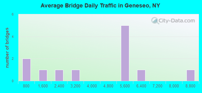
- 45,974Total average daily traffic
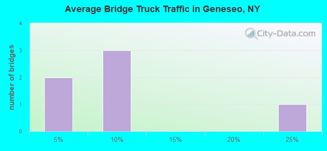
- 2,361Total average daily truck traffic
- National Bridge Inventory (NBI) Registered Bridges for Geneseo
- No street view available for this location
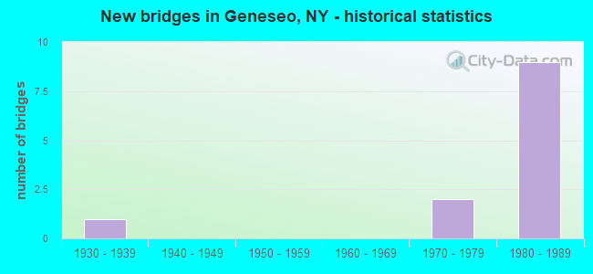
- New bridges - historical statistics
- 11930-1939
- 21970-1979
- 91980-1989
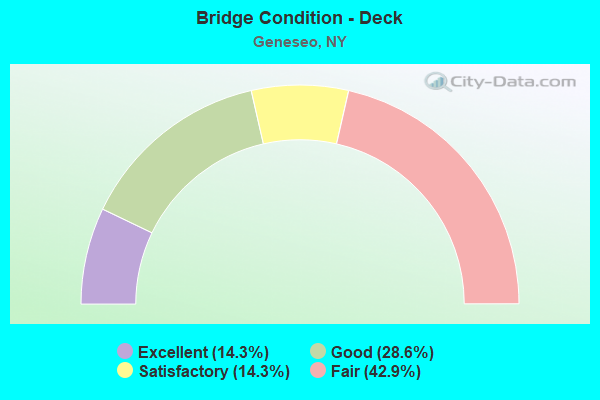
- Bridge Condition - Deck
- 14.3%Excellent
- 28.6%Good
- 14.3%Satisfactory
- 42.9%Fair
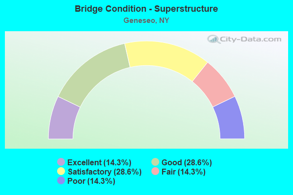
- Bridge Condition - Superstructure
- 14.3%Excellent
- 28.6%Good
- 28.6%Satisfactory
- 14.3%Fair
- 14.3%Poor
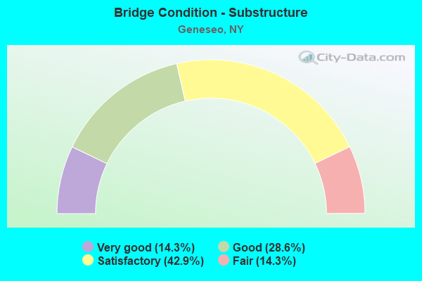
- Bridge Condition - Substructure
- 14.3%Very good
- 28.6%Good
- 42.9%Satisfactory
- 14.3%Fair
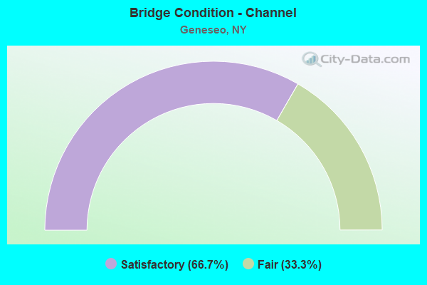
- Bridge Condition - Channel
- 66.7%Satisfactory
- 33.3%Fair
Find on map >> Show street view
Structure Number: 10162, Location: JCT RTE 20A + GENESEE R (Lat: 42.777064, Lng: -77.841100), Route carried "on" structure: US 20A, Year Built: 1970, Status: Open, Structure Length: 7.56m (24.80ft), Average Daily Traffic: 5,734 (year 2018), Truck Traffic: 6%, Average Future Daily Traffic: 5,769 (year 2040), Design Load: HS 20, Features Intersected: GENESEE RIVER
Minimum Vertical Clearance: 30+ m (98+ ft), Kilometerpoint: 10.668, Lanes on structure: 2, Base Highway Network: Yes, Owner: State Highway Agency, Approaching Roadway Width: 14.6m (47.9ft), Material/Design: Steel, Design/Construction: Stringer/Multi-beam, Number Of Spans In Main Unit: 3, Length of Maximum Span: 35.4m (116.1ft), Curb-To-Curb Width: 14.3m (46.9ft), Out-to-Out Width: 15.2m (49.9ft)
Condition: Deck: Fair, Superstructure: Poor, Substructure: Satisfactory, Channel: Satisfactory, Operating Rating: 69.9 metric tons, Method Used To Determine Operating Rating: Load Factor (LF), Inventory Rating: 41.7 metric tons, Method Used To Determine Inventory Rating: Load Factor (LF), Structural Evaluation: Meets minimum limits, Deck Geometry: Superior to present desirable criteria, Waterway Adequacy: Equal to present minimum criteria, Approach Roadway Alignment: Equal to present desirable criteria, Length Of Structure Improvement: 7.55m (24.77ft), Designated Inspection Frequency: Every 24 months, Inspection Date: September 2021, Bridge Improvement Cost: $2,687,000, Roadway Improvement Cost: $1,574,000, Total Project Cost: $4,261,000 ( Estimate for 2021), Deck Structure Type: Concrete Cast-file-Place, Wearing Surface/Protective System: Wearing Surface: Bituminous, Membrane: Other
Find on map >> Show street view
Structure Number: 102462, Location: 3.4MI NE JCT RTS 39 + 20A (Lat: 42.837692, Lng: -77.784147), Route carried "on" structure: State highway 39, Year Built: 1931, Status: Open, Structure Length: 0.85m (2.79ft), Average Daily Traffic: 2,962 (year 2018), Truck Traffic: 6%, Average Future Daily Traffic: 2,980 (year 2040), Features Intersected: JAYCOX CREEK
Minimum Vertical Clearance: 30+ m (98+ ft), Kilometerpoint: 20.032, Lanes on structure: 2, Base Highway Network: Yes, Owner: State Highway Agency, Approaching Roadway Width: 11.0m (36.1ft), Skew: 1 degrees, Material/Design: Concrete, Design/Construction: Frame, Number Of Spans In Main Unit: 1, Length of Maximum Span: 7.3m (24.0ft), Curb-To-Curb Width: 11.0m (36.1ft), Out-to-Out Width: 20.1m (65.9ft)
Condition: Deck: Fair, Superstructure: Fair, Substructure: Good, Channel: Fair, Inventory Rating: 63.5 metric tons, Method Used To Determine Inventory Rating: Load Factor (LF), Structural Evaluation: Somewhat better than minimum adequacy, Deck Geometry: Somewhat better than minimum adequacy, Waterway Adequacy: Equal to present minimum criteria, Approach Roadway Alignment: Equal to present desirable criteria, Length Of Structure Improvement: 0.85m (2.79ft), Designated Inspection Frequency: Every 24 months, Inspection Date: April 2020, Bridge Improvement Cost: $624,000, Roadway Improvement Cost: $365,000, Total Project Cost: $989,000 ( Estimate for 2021), Wearing Surface/Protective System: Wearing Surface: Bituminous
Find on map >> Show street view
Structure Number: 107176, Location: 2.0MI N JCT RTS 63 & 408 (Lat: 42.764247, Lng: -77.829431), Route carried "on" structure: State highway 63, Year Built: 1982, Status: Open, Structure Length: 10.30m (33.79ft), Average Daily Traffic: 8,668 (year 2017), Truck Traffic: 20%, Average Future Daily Traffic: 8,750 (year 2040), Design Load: HS 20, Features Intersected: 390I390I42021198, RTE I3
Minimum Vertical Clearance: 30+ m (98+ ft), Kilometerpoint: 30.185, Lanes on structure: 2, Lanes under structure: 4, Base Highway Network: Yes, Owner: State Highway Agency, Approaching Roadway Width: 14.6m (47.9ft), Skew: 4 degrees, Material/Design: Steel continuous, Design/Construction: Stringer/Multi-beam, Number Of Spans In Main Unit: 2, Length of Maximum Span: 50.5m (165.7ft), Curb-To-Curb Width: 14.6m (47.9ft), Out-to-Out Width: 15.5m (50.9ft)
Condition: Deck: Fair, Superstructure: Satisfactory, Substructure: Fair, Operating Rating: 54.8 metric tons, Method Used To Determine Operating Rating: Load and Resistance Factor Rating (LRFR) rating reported by rating factor(RF) method using HL-93 loadings, Inventory Rating: 42.1 metric tons, Method Used To Determine Inventory Rating: Load and Resistance Factor Rating (LRFR) rating reported by rating factor(RF) method using HL-93 loadings, Structural Evaluation: Somewhat better than minimum adequacy, Deck Geometry: Superior to present desirable criteria, Underclear: High priority of corrective action, Approach Roadway Alignment: Equal to present desirable criteria, Length Of Structure Improvement: 10.30m (33.79ft), Designated Inspection Frequency: Every 24 months, Inspection Date: August 2020, Bridge Improvement Cost: $4,103,000, Roadway Improvement Cost: $2,403,000, Total Project Cost: $6,506,000 ( Estimate for 2021), Deck Structure Type: Concrete Cast-file-Place, Wearing Surface/Protective System: Wearing Surface: Bituminous, Membrane: Other, Deck Protection: Epoxy Coated Reinforcing
Find on map >> Show street view
Structure Number: 107177, Location: 1.0MI S GENESEO VIL LIV C (Lat: 42.773617, Lng: -77.811439), Route carried "on" structure: Other road , Year Built: 1982, Status: Open, Structure Length: 8.90m (29.20ft), Average Daily Traffic: 1,919 (year 2016), Truck Traffic: 2%, Average Future Daily Traffic: 2,687 (year 2036), Design Load: HS 20, Features Intersected: 390I390I42021208 SB, RTE, Facility Carried by Structure: CROSSETT ROAD
Minimum Vertical Clearance: 30+ m (98+ ft), Kilometerpoint: 2.333, Lanes on structure: 2, Lanes under structure: 4, Owner: State Highway Agency, Approaching Roadway Width: 9.4m (30.8ft), Skew: 2 degrees, Material/Design: Steel continuous, Design/Construction: Stringer/Multi-beam, Number Of Spans In Main Unit: 2, Length of Maximum Span: 43.5m (142.7ft), Curb-To-Curb Width: 9.4m (30.8ft), Out-to-Out Width: 10.4m (34.1ft)
Condition: Deck: Good, Superstructure: Good, Substructure: Satisfactory, Operating Rating: 81.6 metric tons, Method Used To Determine Operating Rating: Load Factor (LF), Inventory Rating: 49.0 metric tons, Method Used To Determine Inventory Rating: Load Factor (LF), Structural Evaluation: Equal to present minimum criteria, Deck Geometry: Somewhat better than minimum adequacy, Underclear: Equal to present desirable criteria, Approach Roadway Alignment: Equal to present desirable criteria, Length Of Structure Improvement: 8.90m (29.20ft), Designated Inspection Frequency: Every 24 months, Inspection Date: August 2020, Bridge Improvement Cost: $2,228,000, Roadway Improvement Cost: $1,305,000, Total Project Cost: $3,532,000 ( Estimate for 2021), Deck Structure Type: Concrete Cast-file-Place, Wearing Surface/Protective System: Wearing Surface: Bituminous, Deck Protection: Epoxy Coated Reinforcing
Find on map >> Show street view
Structure Number: 107178, Location: 1 MI SE GENESEO LIV CO LN (Lat: 42.776642, Lng: -77.791181), Route carried "on" structure: County highway , Year Built: 1982, Status: Open, Structure Length: 9.11m (29.89ft), Average Daily Traffic: 1,244 (year 2017), Truck Traffic: 5%, Average Future Daily Traffic: 1,297 (year 2040), Design Load: HS 20, Features Intersected: I-390 SB, RTE I390, Facility Carried by Structure: GROVELAND ROAD
Minimum Vertical Clearance: 30+ m (98+ ft), Kilometerpoint: 4.747, Lanes on structure: 2, Lanes under structure: 4, Owner: State Highway Agency, Approaching Roadway Width: 11.3m (37.1ft), Skew: 3 degrees, Material/Design: Steel continuous, Design/Construction: Stringer/Multi-beam, Number Of Spans In Main Unit: 2, Length of Maximum Span: 44.8m (147.0ft), Curb-To-Curb Width: 11.3m (37.1ft), Out-to-Out Width: 12.2m (40.0ft)
Condition: Deck: Satisfactory, Superstructure: Good, Substructure: Satisfactory, Operating Rating: 84.4 metric tons, Method Used To Determine Operating Rating: Load Factor (LF), Inventory Rating: 49.9 metric tons, Method Used To Determine Inventory Rating: Load Factor (LF), Structural Evaluation: Equal to present minimum criteria, Deck Geometry: Equal to present minimum criteria, Underclear: Equal to present minimum criteria, Approach Roadway Alignment: Equal to present desirable criteria, Length Of Structure Improvement: 9.11m (29.89ft), Designated Inspection Frequency: Every 24 months, Inspection Date: October 2021, Bridge Improvement Cost: $2,703,000, Roadway Improvement Cost: $1,583,000, Total Project Cost: $4,286,000 ( Estimate for 2021), Deck Structure Type: Concrete Cast-file-Place, Wearing Surface/Protective System: Wearing Surface: Integral Concrete, Deck Protection: Epoxy Coated Reinforcing
Find on map >> Show street view
Structure Number: 107179, Location: 1.2 MI SE GENESEO LIV CO (Lat: 42.781247, Lng: -77.771100), Route carried "on" structure: County highway , Year Built: 1982, Status: Open, Structure Length: 8.56m (28.08ft), Average Daily Traffic: 386 (year 2018), Truck Traffic: 2%, Average Future Daily Traffic: 540 (year 2038), Design Load: HS 20, Features Intersected: 390I390I42021230 NB, RTE, Facility Carried by Structure: LONG POINT ROAD
Minimum Vertical Clearance: 30+ m (98+ ft), Kilometerpoint: 2.140, Lanes on structure: 2, Lanes under structure: 4, Owner: State Highway Agency, Approaching Roadway Width: 13.4m (44.0ft), Skew: 1 degrees, Material/Design: Steel continuous, Design/Construction: Stringer/Multi-beam, Number Of Spans In Main Unit: 2, Length of Maximum Span: 42.0m (137.8ft), Curb-To-Curb Width: 13.4m (44.0ft), Out-to-Out Width: 14.3m (46.9ft)
Condition: Deck: Good, Superstructure: Satisfactory, Substructure: Good, Operating Rating: 61.7 metric tons, Method Used To Determine Operating Rating: Load Factor (LF), Inventory Rating: 36.3 metric tons, Method Used To Determine Inventory Rating: Load Factor (LF), Structural Evaluation: Equal to present minimum criteria, Deck Geometry: Superior to present desirable criteria, Underclear: Meets minimum limits, Approach Roadway Alignment: Equal to present desirable criteria, Length Of Structure Improvement: 8.56m (28.08ft), Designated Inspection Frequency: Every 24 months, Inspection Date: August 2021, Bridge Improvement Cost: $2,930,000, Roadway Improvement Cost: $1,716,000, Total Project Cost: $4,646,000 ( Estimate for 2021), Deck Structure Type: Concrete Cast-file-Place, Wearing Surface/Protective System: Wearing Surface: Integral Concrete, Deck Protection: Epoxy Coated Reinforcing
Find on map >> Show street view
Structure Number: 331635, Location: 3.0 MI.N.GENESEO (Lat: 42.835106, Lng: -77.812017), Route carried "on" structure: Other road , Year Built: 1978, Year Reconstructed: 2009, Status: Open, Structure Length: 1.22m (4.00ft), Average Daily Traffic: 61 (year 2019), Average Future Daily Traffic: 85 (year 2039), Design Load: H 20, Features Intersected: JAYCOX CREEK, Facility Carried by Structure: NATIONS ROAD
Minimum Vertical Clearance: 30+ m (98+ ft), Kilometerpoint: 1.802, Lanes on structure: 2, Owner: County Highway Agency, Approaching Roadway Width: 7.3m (24.0ft), Skew: 2 degrees, Material/Design: Wood or Timber, Design/Construction: Stringer/Multi-beam, Number Of Spans In Main Unit: 1, Length of Maximum Span: 11.8m (38.7ft), Curb-To-Curb Width: 8.3m (27.2ft), Out-to-Out Width: 9.1m (29.9ft)
Condition: Deck: Excellent, Superstructure: Excellent, Substructure: Very good, Channel: Satisfactory, Operating Rating: 89.8 metric tons, Method Used To Determine Operating Rating: Allowable Stress (AS), Inventory Rating: 64.4 metric tons, Method Used To Determine Inventory Rating: Allowable Stress (AS), Structural Evaluation: Equal to present desirable criteria, Deck Geometry: Equal to present minimum criteria, Waterway Adequacy: Better than present minimum criteria, Approach Roadway Alignment: Somewhat better than minimum adequacy, Length Of Structure Improvement: 1.21m (3.97ft), Designated Inspection Frequency: Every 24 months, Inspection Date: August 2021, Bridge Improvement Cost: $929,000, Roadway Improvement Cost: $544,000, Total Project Cost: $1,473,000 ( Estimate for 2021), Deck Structure Type: Wood or Timber, Wearing Surface/Protective System: Wearing Surface: Bituminous
Find on map >> Show street view
Structure Number: 107176, Location: 2.0MI N JCT RTS 63 & 408 (Lat: 42.764247, Lng: -77.829431), Route carried "under" structure: Interstate 390, Year Built: 1982, Structure Length: 0. m, Average Daily Traffic: 5,000 (year 2021), Features Intersected: 390I390I42021198, RTE I3, Facility Carried by Structure: RTE 63
Minimum Vertical Clearance: 5.41m (17.75ft), Kilometerpoint: 65.808, Lanes on structure: 2, Lanes under structure: 2, Material/Design: Steel continuous, Design/Construction: Stringer/Multi-beam, Length of Maximum Span: 50.5m (165.7ft)
Find on map >> Show street view
Structure Number: 107177, Location: 1.0MI S GENESEO VIL LIV C (Lat: 42.773617, Lng: -77.811439), Route carried "under" structure: Interstate 390, Year Built: 1982, Structure Length: 0. m, Average Daily Traffic: 5,000 (year 2021), Features Intersected: 390I390I42021208 SB, RTE, Facility Carried by Structure: CROSSETT ROAD
Minimum Vertical Clearance: 5.44m (17.85ft), Kilometerpoint: 33.435, Lanes on structure: 2, Lanes under structure: 2, Material/Design: Steel continuous, Design/Construction: Stringer/Multi-beam, Length of Maximum Span: 43.5m (142.7ft)
Find on map >> Show street view
Structure Number: 107178, Location: 1 MI SE GENESEO LIV CO LN (Lat: 42.776642, Lng: -77.791181), Route carried "under" structure: Interstate 390, Year Built: 1982, Structure Length: 0. m, Average Daily Traffic: 5,000 (year 2021), Features Intersected: I-390 SB, RTE I390, Facility Carried by Structure: GROVELAND ROAD
Minimum Vertical Clearance: 5.41m (17.75ft), Kilometerpoint: 35.141, Lanes on structure: 2, Lanes under structure: 2, Material/Design: Steel continuous, Design/Construction: Stringer/Multi-beam, Length of Maximum Span: 44.8m (147.0ft)
Find on map >> Show street view
Structure Number: 107179, Location: 1.2 MI SE GENESEO LIV CO (Lat: 42.781247, Lng: -77.771100), Route carried "under" structure: Interstate 390, Year Built: 1982, Structure Length: 0. m, Average Daily Traffic: 5,000 (year 2021), Features Intersected: 390I390I42021230 NB, RTE, Facility Carried by Structure: LONG POINT ROAD
Minimum Vertical Clearance: 5.38m (17.65ft), Kilometerpoint: 37.055, Lanes on structure: 2, Lanes under structure: 2, Material/Design: Steel continuous, Design/Construction: Stringer/Multi-beam, Length of Maximum Span: 42.0m (137.8ft)
Find on map >> Show street view
Structure Number: 10718, Location: 1.8MI E GENESEO LIV CO (Lat: 42.794333, Lng: -77.761894), Route carried "under" structure: Interstate 390, Year Built: 1982, Structure Length: 0. m, Average Daily Traffic: 5,000 (year 2021), Features Intersected: 390I390I42021240 NB, RTE, Facility Carried by Structure: RESERVOIR ROAD
Minimum Vertical Clearance: 5.46m (17.91ft), Kilometerpoint: 38.696, Lanes on structure: 2, Lanes under structure: 2, Material/Design: Steel continuous, Design/Construction: Stringer/Multi-beam, Length of Maximum Span: 43.2m (141.7ft)