Bridge Statistics for Geneva, New York (NY)
Condition, Traffic, Stress, Structural Evaluation, Project Costs
- National Bridge Inventory (NBI) Statistics
- 16Number of bridges
- 82ft / 25.1mTotal length
- $20,079,000Total costs
- 79,683Total average daily traffic
- 4,311Total average daily truck traffic
- National Bridge Inventory (NBI) Registered Bridges for Geneva
- No street view available for this location
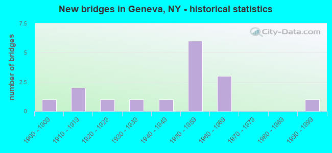
- New bridges - historical statistics
- 11900-1909
- 21910-1919
- 11920-1929
- 11930-1939
- 11940-1949
- 61950-1959
- 31960-1969
- 11990-1999
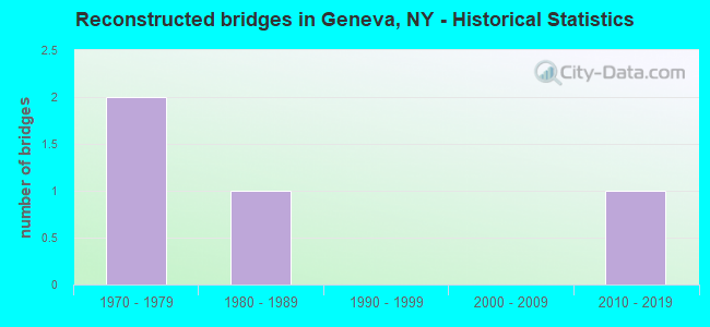
- Reconstructed bridges - Historical Statistics
- 21970-1979
- 11980-1989
- 01990-1999
- 02000-2009
- 12010-2019
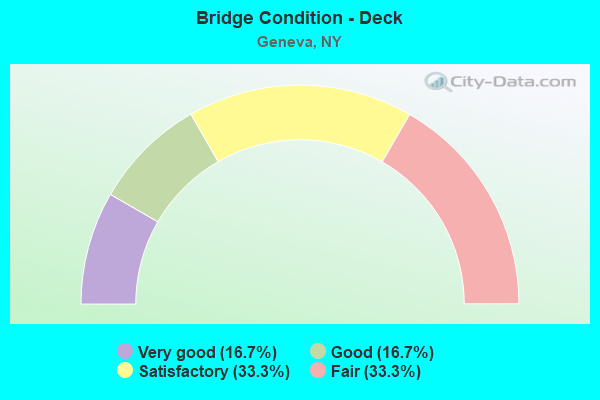
- Bridge Condition - Deck
- 16.7%Very good
- 16.7%Good
- 33.3%Satisfactory
- 33.3%Fair
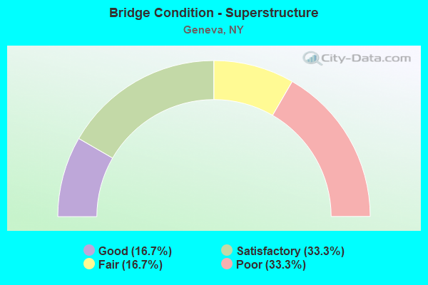
- Bridge Condition - Superstructure
- 16.7%Good
- 33.3%Satisfactory
- 16.7%Fair
- 33.3%Poor
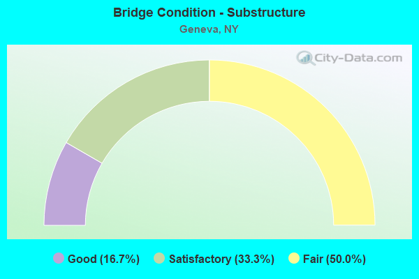
- Bridge Condition - Substructure
- 16.7%Good
- 33.3%Satisfactory
- 50.0%Fair
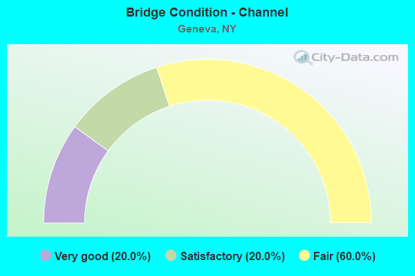
- Bridge Condition - Channel
- 20.0%Very good
- 20.0%Satisfactory
- 60.0%Fair
Find on map >> Show street view
Structure Number: 100192, Location: JCT RTS 5+20 +14 (Lat: 42.861217, Lng: -76.982994), Route carried "on" structure: State highway 14, Year Built: 1952, Status: Open, Structure Length: 2.44m (8.01ft), Average Daily Traffic: 5,517 (year 2020), Truck Traffic: 13%, Average Future Daily Traffic: 5,542 (year 2040), Design Load: H 20, Features Intersected: RTE 5
Minimum Vertical Clearance: 30+ m (98+ ft), Kilometerpoint: 10.909, Lanes on structure: 2, Lanes under structure: 4, Base Highway Network: Yes, Owner: State Highway Agency, Approaching Roadway Width: 13.4m (44.0ft), Material/Design: Concrete, Design/Construction: Frame, Number Of Spans In Main Unit: 1, Length of Maximum Span: 21.3m (69.9ft), Curb or Sidewalk Widths: Left: 2.4m (7.9ft), Right: 2.4m (7.9ft), Curb-To-Curb Width: 13.4m (44.0ft), Out-to-Out Width: 19.0m (62.3ft)
Condition: Deck: Satisfactory, Superstructure: Satisfactory, Substructure: Satisfactory, Operating Rating: 59.1 metric tons, Method Used To Determine Operating Rating: Field evaluation and documented engineering judgment, Inventory Rating: 21.0 metric tons, Method Used To Determine Inventory Rating: Field evaluation and documented engineering judgment, Structural Evaluation: Somewhat better than minimum adequacy, Deck Geometry: Equal to present minimum criteria, Underclear: Meets minimum limits, Approach Roadway Alignment: Equal to present minimum criteria, Length Of Structure Improvement: 2.43m (7.97ft), Designated Inspection Frequency: Every 24 months, Inspection Date: July 2020, Bridge Improvement Cost: $1,790,000, Roadway Improvement Cost: $1,048,000, Total Project Cost: $2,839,000 ( Estimate for 2021), Wearing Surface/Protective System: Wearing Surface: Monolithic Concrete
Find on map >> Show street view
Structure Number: 1001939, Location: .1 MI E JCT SH5/US20&SH14 (Lat: 42.861783, Lng: -76.981664), Route carried "on" structure: State highway 5, Year Built: 1952, Year Reconstructed: 2015, Status: Open, Structure Length: 10.18m (33.40ft), Average Daily Traffic: 12,682 (year 2018), Truck Traffic: 8%, Average Future Daily Traffic: 12,741 (year 2040), Design Load: H 20, Features Intersected: NOR SO/FINGER LKS
Minimum Vertical Clearance: 30+ m (98+ ft), Kilometerpoint: 49.380, Lanes on structure: 4, Base Highway Network: Yes, Owner: State Highway Agency, Approaching Roadway Width: 18.6m (61.0ft), Skew: 31 degrees, Material/Design: Steel, Design/Construction: Stringer/Multi-beam, Number Of Spans In Main Unit: 5, Length of Maximum Span: 21.6m (70.9ft), Curb-To-Curb Width: 18.7m (61.4ft), Out-to-Out Width: 21.1m (69.2ft)
Condition: Deck: Very good, Superstructure: Good, Substructure: Good, Operating Rating: 71.7 metric tons, Method Used To Determine Operating Rating: Load Factor (LF), Inventory Rating: 42.6 metric tons, Method Used To Determine Inventory Rating: Load Factor (LF), Structural Evaluation: Better than present minimum criteria, Deck Geometry: Equal to present minimum criteria, Underclear: Meets minimum limits, Approach Roadway Alignment: Equal to present minimum criteria, Length Of Structure Improvement: 10.18m (33.40ft), Designated Inspection Frequency: Every 24 months, Inspection Date: September 2021, Bridge Improvement Cost: $5,048,000, Roadway Improvement Cost: $2,956,000, Total Project Cost: $8,004,000 ( Estimate for 2021), Deck Structure Type: Concrete Cast-file-Place, Wearing Surface/Protective System: Wearing Surface: Monolithic Concrete
Find on map >> Show street view
Structure Number: 101097, Location: 3.4MI S JCT RTS 14 + 5+20 (Lat: 42.812203, Lng: -76.976986), Route carried "on" structure: State highway 14, Year Built: 1949, Year Reconstructed: 1988, Status: Open, Structure Length: 1.34m (4.40ft), Average Daily Traffic: 3,707 (year 2018), Truck Traffic: 17%, Average Future Daily Traffic: 3,724 (year 2040), Features Intersected: WILSON CREEK
Minimum Vertical Clearance: 30+ m (98+ ft), Kilometerpoint: 5.390, Lanes on structure: 2, Base Highway Network: Yes, Owner: State Highway Agency, Approaching Roadway Width: 12.2m (40.0ft), Material/Design: Steel, Design/Construction: Stringer/Multi-beam, Number Of Spans In Main Unit: 1, Length of Maximum Span: 12.8m (42.0ft), Curb-To-Curb Width: 11.7m (38.4ft), Out-to-Out Width: 12.3m (40.4ft)
Condition: Deck: Good, Superstructure: Satisfactory, Substructure: Fair, Channel: Satisfactory, Inventory Rating: 59.9 metric tons, Method Used To Determine Inventory Rating: Load Factor (LF), Structural Evaluation: Somewhat better than minimum adequacy, Deck Geometry: Somewhat better than minimum adequacy, Waterway Adequacy: Equal to present minimum criteria, Approach Roadway Alignment: Equal to present desirable criteria, Length Of Structure Improvement: 1.34m (4.40ft), Designated Inspection Frequency: Every 24 months, Inspection Date: October 2021, Bridge Improvement Cost: $725,000, Roadway Improvement Cost: $424,000, Total Project Cost: $1,149,000 ( Estimate for 2021), Deck Structure Type: Concrete Cast-file-Place, Wearing Surface/Protective System: Wearing Surface: Epoxy Overlay, Deck Protection: Epoxy Coated Reinforcing
Find on map >> Show street view
Structure Number: 1010999, Location: 4.1 MI N OF GENEVA (Lat: 42.947167, Lng: -76.977811), Route carried "on" structure: State highway 96, Year Built: 1958, Year Reconstructed: 1976, Status: Open, Structure Length: 6.83m (22.41ft), Average Daily Traffic: 6,636 (year 2020), Truck Traffic: 14%, Average Future Daily Traffic: 6,677 (year 2040), Design Load: HS 20, Features Intersected: RTE 14
Minimum Vertical Clearance: 30+ m (98+ ft), Kilometerpoint: 1.432, Lanes on structure: 4, Lanes under structure: 4, Base Highway Network: Yes, Owner: State Highway Agency, Approaching Roadway Width: 21.3m (69.9ft), Skew: 31 degrees, Material/Design: Steel, Design/Construction: Stringer/Multi-beam, Number Of Spans In Main Unit: 3, Length of Maximum Span: 24.9m (81.7ft), Curb-To-Curb Width: 20.8m (68.2ft), Out-to-Out Width: 21.7m (71.2ft)
Condition: Deck: Fair, Superstructure: Fair, Substructure: Fair, Operating Rating: 87.1 metric tons, Method Used To Determine Operating Rating: Load Factor (LF), Inventory Rating: 51.7 metric tons, Method Used To Determine Inventory Rating: Load Factor (LF), Structural Evaluation: Somewhat better than minimum adequacy, Deck Geometry: Superior to present desirable criteria, Underclear: Meets minimum limits, Approach Roadway Alignment: Superior to present desirable criteria, Length Of Structure Improvement: 6.82m (22.38ft), Designated Inspection Frequency: Every 24 months, Inspection Date: December 2021, Bridge Improvement Cost: $3,625,000, Roadway Improvement Cost: $2,123,000, Total Project Cost: $5,749,000 ( Estimate for 2021), Deck Structure Type: Concrete Cast-file-Place, Wearing Surface/Protective System: Wearing Surface: Bituminous
Find on map >> Show street view
Structure Number: 10743, Location: 2000FTEASTINTLAKEST&RTE05 (Lat: 42.872569, Lng: -76.972333), Route carried "on" structure: State highway 5, Year Built: 1958, Status: Open, Structure Length: 1.10m (3.61ft), Average Daily Traffic: 11,242 (year 2020), Truck Traffic: 4%, Average Future Daily Traffic: 11,294 (year 2040), Features Intersected: MARSH CREEK
Minimum Vertical Clearance: 30+ m (98+ ft), Kilometerpoint: 51.005, Lanes on structure: 4, Base Highway Network: Yes, Owner: State Highway Agency, Approaching Roadway Width: 15.8m (51.8ft), Skew: 20 degrees, Material/Design: Steel, Design/Construction: Culvert, Number Of Spans In Main Unit: 3, Length of Maximum Span: 3.0m (9.8ft)
Condition: Channel: Fair, Culverts: Satisfactory, Operating Rating: 74.8 metric tons, Method Used To Determine Operating Rating: Field evaluation and documented engineering judgment, Inventory Rating: 32.7 metric tons, Method Used To Determine Inventory Rating: Field evaluation and documented engineering judgment, Structural Evaluation: Equal to present minimum criteria, Waterway Adequacy: Equal to present minimum criteria, Approach Roadway Alignment: Equal to present desirable criteria, Length Of Structure Improvement: 1.09m (3.58ft), Designated Inspection Frequency: Every 24 months, Underwater Inspection Frequency: Every 60 months, Inspection Date: September 2021, Underwater Inspection Date: June 2021, Bridge Improvement Cost: $520,000, Roadway Improvement Cost: $304,000, Total Project Cost: $824,000 ( Estimate for 2021)
Find on map >> Show street view
Structure Number: 221169, Location: 3.2 MI S OF GENEVA (Lat: 42.818039, Lng: -77.000608), Route carried "on" structure: Other road , Year Built: 1925, Year Reconstructed: 1978, Status: Posted for load, Structure Length: 0.98m (3.22ft), Average Daily Traffic: 61 (year 2016), Truck Traffic: 5%, Average Future Daily Traffic: 85 (year 2036), Design Load: HS 20, Features Intersected: WILSON CREEK, Facility Carried by Structure: SLATE ROCK ROAD
Minimum Vertical Clearance: 30+ m (98+ ft), Kilometerpoint: 0.853, Lanes on structure: 2, Owner: Town or Township Highway Agency, Approaching Roadway Width: 6.1m (20.0ft), Material/Design: Wood or Timber, Design/Construction: Slab, Number Of Spans In Main Unit: 1, Length of Maximum Span: 8.8m (28.9ft), Curb-To-Curb Width: 6.6m (21.7ft), Out-to-Out Width: 7.9m (25.9ft)
Condition: Deck: Satisfactory, Superstructure: Poor, Substructure: Fair, Channel: Very good, Operating Rating: 51.7 metric tons, Method Used To Determine Operating Rating: Allowable Stress (AS), Inventory Rating: 35.4 metric tons, Method Used To Determine Inventory Rating: Allowable Stress (AS), Structural Evaluation: Meets minimum limits, Deck Geometry: Somewhat better than minimum adequacy, Waterway Adequacy: Equal to present desirable criteria, Approach Roadway Alignment: Equal to present minimum criteria, Bridge Posting: Required (Relationship of Operating Rating to Maximum Legal Load: > 39.9% below), Length Of Structure Improvement: 0.97m (3.18ft), Designated Inspection Frequency: Every 12 months, Inspection Date: April 2021, Bridge Improvement Cost: $323,000, Roadway Improvement Cost: $189,000, Total Project Cost: $513,000 ( Estimate for 2021), Wearing Surface/Protective System: Wearing Surface: Bituminous
Find on map >> Show street view
Structure Number: 221178, Location: CITY OF GENEVA (Lat: 42.873458, Lng: -76.973517), Route carried "on" structure: City street , Year Built: 1960, Status: Open, Structure Length: 1.34m (4.40ft), Average Daily Traffic: 748 (year 2016), Truck Traffic: 3%, Average Future Daily Traffic: 1,047 (year 2036), Features Intersected: MARSH CREEK, Facility Carried by Structure: MIDDLE STREET
Minimum Vertical Clearance: 30+ m (98+ ft), Kilometerpoint: 0.499, Lanes on structure: 2, Owner: City or Municipal Highway Agency, Approaching Roadway Width: 7.0m (23.0ft), Skew: 2 degrees, Material/Design: Prestressed concrete, Design/Construction: Box Beam or Girders - Multiple, Number Of Spans In Main Unit: 1, Length of Maximum Span: 12.8m (42.0ft), Curb or Sidewalk Widths: Left: 0.8m (2.6ft), Right: 0.0m, Curb-To-Curb Width: 7.3m (24.0ft), Out-to-Out Width: 8.5m (27.9ft)
Condition: Deck: Fair, Superstructure: Poor, Substructure: Satisfactory, Channel: Fair, Operating Rating: 32.4 metric tons, Method Used To Determine Operating Rating: Load and Resistance Factor Rating (LRFR) rating reported by rating factor(RF) method using HL-93 loadings, Inventory Rating: 24.9 metric tons, Method Used To Determine Inventory Rating: Load and Resistance Factor Rating (LRFR) rating reported by rating factor(RF) method using HL-93 loadings, Structural Evaluation: Meets minimum limits, Deck Geometry: Meets minimum limits, Waterway Adequacy: Better than present minimum criteria, Approach Roadway Alignment: Equal to present desirable criteria, Length Of Structure Improvement: 1.34m (4.40ft), Designated Inspection Frequency: Every 24 months, Inspection Date: April 2021, Bridge Improvement Cost: $361,000, Roadway Improvement Cost: $212,000, Total Project Cost: $573,000 ( Estimate for 2021), Wearing Surface/Protective System: Wearing Surface: Bituminous
Find on map >> Show street view
Structure Number: 331868, Location: 1.5 MI W OF GENEVA (Lat: 42.875311, Lng: -77.011244), Route carried "on" structure: County highway , Year Built: 1993, Status: Open, Structure Length: 0.91m (2.99ft), Average Daily Traffic: 7,822 (year 2020), Truck Traffic: 7%, Average Future Daily Traffic: 9,502 (year 2040), Design Load: HS 25 or greater, Features Intersected: CASTLE CREEK, Facility Carried by Structure: PREMPTION ROAD
Minimum Vertical Clearance: 30+ m (98+ ft), Kilometerpoint: 12.534, Lanes on structure: 3, Owner: County Highway Agency, Approaching Roadway Width: 15.2m (49.9ft), Material/Design: Concrete, Design/Construction: Culvert, Number Of Spans In Main Unit: 1, Length of Maximum Span: 8.5m (27.9ft), Curb-To-Curb Width: 15.8m (51.8ft), Out-to-Out Width: 16.5m (54.1ft)
Condition: Channel: Fair, Culverts: Satisfactory, Operating Rating: 78.7 metric tons, Method Used To Determine Operating Rating: Field evaluation and documented engineering judgment, Inventory Rating: 40.8 metric tons, Method Used To Determine Inventory Rating: Field evaluation and documented engineering judgment, Structural Evaluation: Equal to present minimum criteria, Deck Geometry: Better than present minimum criteria, Waterway Adequacy: Equal to present minimum criteria, Approach Roadway Alignment: Equal to present desirable criteria, Length Of Structure Improvement: 0.91m (2.99ft), Designated Inspection Frequency: Every 24 months, Inspection Date: May 2021, Bridge Improvement Cost: $270,000, Roadway Improvement Cost: $158,000, Total Project Cost: $428,000 ( Estimate for 2021)
Find on map >> Show street view
Structure Number: 100192, Location: JCT RTS 5+20 +14 (Lat: 42.861217, Lng: -76.982994), Route carried "under" structure: State highway 5, Year Built: 1952, Structure Length: 0. m, Average Daily Traffic: 6,500 (year 1971), Features Intersected: RTE 5, Facility Carried by Structure: RTE 14
Minimum Vertical Clearance: 4.85m (15.91ft), Kilometerpoint: 32.421, Lanes on structure: 2, Lanes under structure: 4, Material/Design: Concrete, Design/Construction: Frame, Length of Maximum Span: 21.3m (69.9ft)
Find on map >> Show street view
Structure Number: 1010999, Location: 4.1 MI N OF GENEVA (Lat: 42.947167, Lng: -76.977811), Route carried "under" structure: State highway 14, Year Built: 1958, Structure Length: 0. m, Average Daily Traffic: 6,447 (year 1998), Features Intersected: RTE 14, Facility Carried by Structure: RTE 96
Minimum Vertical Clearance: 4.47m (14.67ft), Kilometerpoint: 7.047, Lanes on structure: 4, Lanes under structure: 4, Material/Design: Steel, Design/Construction: Stringer/Multi-beam, Length of Maximum Span: 24.9m (81.7ft)
Find on map >> Show street view
Structure Number: 700195, Location: 0.2 MI W JCT RTS 5 + 96A (Lat: 42.875619, Lng: -76.946506), Route carried "under" structure: State highway 5, Year Built: 1960, Structure Length: 0. m, Average Daily Traffic: 13,761 (year 1999), Features Intersected: RTE 5, U S NUMBERED 20, Facility Carried by Structure: FINGER LAKES
Minimum Vertical Clearance: 4.74m (15.55ft), Kilometerpoint: 1.335, Lanes under structure: 4, Material/Design: Steel, Design/Construction: Stringer/Multi-beam, Length of Maximum Span: 18.2m (59.7ft)
Find on map >> Show street view
Structure Number: 700195, Location: 0.2 MI W JCT RTS 5 + 96A (Lat: 42.875619, Lng: -76.946506), Route carried "under" structure: US , Year Built: 1960, Structure Length: 0. m, Average Daily Traffic: 100 (year 2021), Features Intersected: RTE 5, U S NUMBERED 20, Facility Carried by Structure: FINGER LAKES
Minimum Vertical Clearance: 4.74m (15.55ft), Kilometerpoint: 0.000, Lanes under structure: 4, Material/Design: Steel, Design/Construction: Stringer/Multi-beam, Length of Maximum Span: 18.2m (59.7ft)
Find on map >> Show street view
Structure Number: 703509, Location: 0.2MI E JCT RTS 96 + 14 (Lat: 42.945364, Lng: -76.973778), Route carried "under" structure: State highway 96, Year Built: 1931, Structure Length: 0. m, Average Daily Traffic: 4,430 (year 1999), Features Intersected: RTE 96, Facility Carried by Structure: NORFOLK SOUTHERN
Minimum Vertical Clearance: 4.34m (14.24ft), Kilometerpoint: 1.078, Lanes under structure: 2, Material/Design: Steel, Design/Construction: Stringer/Multi-beam, Length of Maximum Span: 14.0m (45.9ft)
Find on map >> Show street view
Structure Number: 770705, Location: IN CITY OF GENEVA (Lat: 42.881183, Lng: -76.980892), Route carried "under" structure: City street , Year Built: 1901, Structure Length: 0. m, Features Intersected: GATES AVENUE, Facility Carried by Structure: FINGER LAKES
Minimum Vertical Clearance: 3.96m (12.99ft), Kilometerpoint: 0.000, Lanes under structure: 2, Material/Design: Steel, Length of Maximum Span: 10.0m (32.8ft)
Find on map >> Show street view
Structure Number: 7707091, Location: CITY OF GENEVA (Lat: 42.877914, Lng: -76.971994), Route carried "under" structure: City street , Year Built: 1916, Structure Length: 0. m, Features Intersected: DORAN AVENUE, Facility Carried by Structure: ABANDONED L V RR
Minimum Vertical Clearance: 4.87m (15.98ft), Kilometerpoint: 0.000, Lanes under structure: 2, Material/Design: Steel, Design/Construction: Stringer/Multi-beam, Length of Maximum Span: 14.6m (47.9ft)
Find on map >> Show street view
Structure Number: 7707092, Location: CITY OF GENEVA (Lat: 42.877903, Lng: -76.972081), Route carried "under" structure: City street , Year Built: 1916, Structure Length: 0. m, Average Daily Traffic: 30 (year 2021), Features Intersected: DORAN AVENUE, Facility Carried by Structure: ABANDONED L V RR
Minimum Vertical Clearance: 4.87m (15.98ft), Kilometerpoint: 0.000, Lanes under structure: 2, Material/Design: Steel, Design/Construction: Stringer/Multi-beam, Length of Maximum Span: 14.6m (47.9ft)