Bridge Statistics for George, Washington (WA)
Condition, Traffic, Stress, Structural Evaluation, Project Costs
- National Bridge Inventory (NBI) Statistics
- 23Number of bridges
- 184ft / 56.4mTotal length
- $34,054,000Total costs
- 73,829Total average daily traffic
- 17,225Total average daily truck traffic
- National Bridge Inventory (NBI) Registered Bridges for George
- No street view available for this location
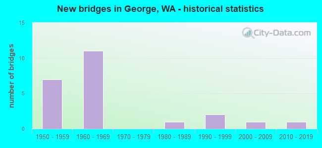
- New bridges - historical statistics
- 71950-1959
- 111960-1969
- 11980-1989
- 21990-1999
- 12000-2009
- 12010-2019

- Reconstructed bridges - Historical Statistics
- 11980-1989
- 21990-1999
- 02000-2009
- 02010-2019
- 12020-2022


- Bridge Condition - Deck
- 10.5%Very good
- 57.9%Good
- 5.3%Satisfactory
- 5.3%Fair
- 10.5%Poor
- 10.5%Serious

- Bridge Condition - Superstructure
- 21.1%Very good
- 36.8%Good
- 26.3%Satisfactory
- 15.8%Fair

- Bridge Condition - Substructure
- 26.3%Very good
- 42.1%Good
- 21.1%Satisfactory
- 10.5%Fair

- Bridge Condition - Channel
- 46.7%Very good
- 46.7%Good
- 6.7%Fair
Find on map >> Show street view
Structure Number: 11WC025, Location: West Canal W39.9 Station (Lat: 47.153686, Lng: -119.853067), Route carried "on" structure: ServiceOther road , Year Built: 1950, Year Reconstructed: 2020, Status: Posted for load, Structure Length: 1.21m (3.97ft), Average Daily Traffic: 40 (year 2020), Average Future Daily Traffic: 40 (year 2040), Design Load: H 10, Features Intersected: WEST CANAL W39.9, Facility Carried by Structure: MAINTENANCE ROAD
Minimum Vertical Clearance: 30+ m (98+ ft), Kilometerpoint: 0.000, Lanes on structure: 1, Owner: Bureau of Reclamation, Maintenance Responsibility: Private, Approaching Roadway Width: 5.0m (16.4ft), Material/Design: Wood or Timber, Design/Construction: Stringer/Multi-beam, Number Of Spans In Main Unit: 2, Length of Maximum Span: 5.8m (19.0ft), Curb-To-Curb Width: 4.9m (16.1ft), Out-to-Out Width: 4.9m (16.1ft)
Condition: Deck: Good, Superstructure: Good, Substructure: Good, Channel: Good, Operating Rating: 30.4 metric tons, Method Used To Determine Operating Rating: Allowable Stress (AS), Inventory Rating: 22.1 metric tons, Method Used To Determine Inventory Rating: Allowable Stress (AS), Structural Evaluation: Equal to present minimum criteria, Deck Geometry: High priority of corrective action, Waterway Adequacy: Superior to present desirable criteria, Approach Roadway Alignment: Equal to present desirable criteria, Bridge Posting: Required (Relationship of Operating Rating to Maximum Legal Load: 30.0 - 39.9% below), Designated Inspection Frequency: Every 24 months, Inspection Date: November 2020, Deck Structure Type: Wood or Timber
Find on map >> Show street view
Structure Number: 11WC0251, Location: West Canal W39.9 Station (Lat: 47.149567, Lng: -119.853081), Route carried "on" structure: ServiceOther road , Year Built: 2016, Status: Posted for load, Structure Length: 1.19m (3.90ft), Average Daily Traffic: 10 (year 2020), Average Future Daily Traffic: 10 (year 2040), Features Intersected: WEST CANAL W39.9, Facility Carried by Structure: MAINTENANCE ROAD
Minimum Vertical Clearance: 30+ m (98+ ft), Kilometerpoint: 0.000, Lanes on structure: 1, Owner: Bureau of Reclamation, Maintenance Responsibility: Private, Approaching Roadway Width: 4.6m (15.1ft), Material/Design: Steel, Design/Construction: Stringer/Multi-beam, Number Of Spans In Main Unit: 1, Length of Maximum Span: 9.4m (30.8ft), Curb-To-Curb Width: 4.2m (13.8ft), Out-to-Out Width: 4.3m (14.1ft)
Condition: Deck: Very good, Superstructure: Very good, Substructure: Fair, Channel: Good, Operating Rating: 21.4 metric tons, Method Used To Determine Operating Rating: Load and Resistance Factor Rating (LRFR) rating reported by rating factor(RF) method using HL-93 loadings, Inventory Rating: 16.5 metric tons, Method Used To Determine Inventory Rating: Load and Resistance Factor Rating (LRFR) rating reported by rating factor(RF) method using HL-93 loadings, Structural Evaluation: Somewhat better than minimum adequacy, Deck Geometry: Somewhat better than minimum adequacy, Waterway Adequacy: Superior to present desirable criteria, Approach Roadway Alignment: Equal to present desirable criteria, Bridge Posting: Required (Relationship of Operating Rating to Maximum Legal Load: > 39.9% below), Designated Inspection Frequency: Every 24 months, Inspection Date: November 2020, Deck Structure Type: Concrete Cast-file-Place
Find on map >> Show street view
Structure Number: 11WC0252, Location: West Canal W39.9 Station (Lat: 47.143164, Lng: -119.853092), Route carried "on" structure: ServiceOther road , Year Built: 1950, Year Reconstructed: 2003, Status: Posted for load, Structure Length: 1.43m (4.69ft), Average Daily Traffic: 20 (year 2020), Average Future Daily Traffic: 20 (year 2040), Features Intersected: WEST CANAL W39.9, Facility Carried by Structure: MAINTENANCE ROAD
Minimum Vertical Clearance: 30+ m (98+ ft), Kilometerpoint: 0.000, Lanes on structure: 2, Owner: Bureau of Reclamation, Maintenance Responsibility: Private, Approaching Roadway Width: 6.0m (19.7ft), Material/Design: Steel, Design/Construction: Stringer/Multi-beam, Number Of Spans In Main Unit: 1, Length of Maximum Span: 11.9m (39.0ft), Curb or Sidewalk Widths: Left: 0.1m (0.3ft), Right: 0.1m (0.3ft), Curb-To-Curb Width: 5.7m (18.7ft), Out-to-Out Width: 5.9m (19.4ft)
Condition: Deck: Fair, Superstructure: Fair, Substructure: Very good, Channel: Good, Operating Rating: 17.9 metric tons, Method Used To Determine Operating Rating: Load Factor (LF), Inventory Rating: 10.7 metric tons, Method Used To Determine Inventory Rating: Load Factor (LF), Structural Evaluation: High priority of corrective action, Deck Geometry: Meets minimum limits, Waterway Adequacy: Superior to present desirable criteria, Approach Roadway Alignment: Equal to present desirable criteria, Bridge Posting: Required (Relationship of Operating Rating to Maximum Legal Load: 20.0 - 29.9% below), Designated Inspection Frequency: Every 24 months, Critical Feature Inspection Frequency: Every 24 months, Inspection Date: November 2020, Critical Feature Inspection Date: November 2020, Deck Structure Type: Steel plate
Find on map >> Show street view
Structure Number: 6858A, Location: 14.0 E JCT SR 26 (Lat: 47.102472, Lng: -119.829611), Route carried "on" structure: Interstate 90, Year Built: 1962, Status: Open, Structure Length: 4.69m (15.39ft), Average Daily Traffic: 6,291 (year 2019), Truck Traffic: 24%, Average Future Daily Traffic: 8,228 (year 2039), Design Load: HS 20, Features Intersected: SR 281 SPUR
Minimum Vertical Clearance: 30+ m (98+ ft), Kilometerpoint: 244.186, Lanes on structure: 3, Lanes under structure: 2, Base Highway Network: Yes, Owner: State Highway Agency, Approaching Roadway Width: 13.4m (44.0ft), Material/Design: Concrete continuous, Design/Construction: Slab, Number Of Spans In Main Unit: 3, Length of Maximum Span: 18.3m (60.0ft), Curb-To-Curb Width: 13.1m (43.0ft), Out-to-Out Width: 14.0m (45.9ft)
Condition: Deck: Satisfactory, Superstructure: Fair, Substructure: Good, Operating Rating: 23.0 metric tons, Method Used To Determine Operating Rating: Load and Resistance Factor Rating (LRFR) rating reported by rating factor(RF) method using HL-93 loadings, Inventory Rating: 17.8 metric tons, Method Used To Determine Inventory Rating: Load and Resistance Factor Rating (LRFR) rating reported by rating factor(RF) method using HL-93 loadings, Structural Evaluation: Meets minimum limits, Deck Geometry: High priority of replacement, Underclear: Equal to present minimum criteria, Approach Roadway Alignment: Equal to present desirable criteria, Length Of Structure Improvement: 4.69m (15.39ft), Designated Inspection Frequency: Every 24 months, Inspection Date: October 2020, Bridge Improvement Cost: $1,417,000, Roadway Improvement Cost: $283,000, Total Project Cost: $2,834,000 ( Estimate for 2014), Deck Structure Type: Concrete Cast-file-Place, Wearing Surface/Protective System: Wearing Surface: Bituminous, Membrane: Preformed Fabric
Find on map >> Show street view
Structure Number: 6858B, Location: 14.0 E JCT SR 26 (Lat: 47.102667, Lng: -119.829722), Route carried "on" structure: Interstate 90, Year Built: 1962, Status: Open, Structure Length: 4.69m (15.39ft), Average Daily Traffic: 6,291 (year 2019), Truck Traffic: 24%, Average Future Daily Traffic: 8,228 (year 2039), Design Load: HS 20, Features Intersected: SR 281 SPUR
Minimum Vertical Clearance: 30+ m (98+ ft), Kilometerpoint: 244.186, Lanes on structure: 2, Lanes under structure: 2, Base Highway Network: Yes, Owner: State Highway Agency, Approaching Roadway Width: 11.9m (39.0ft), Material/Design: Concrete continuous, Design/Construction: Slab, Number Of Spans In Main Unit: 3, Length of Maximum Span: 17.4m (57.1ft), Curb-To-Curb Width: 9.4m (30.8ft), Out-to-Out Width: 10.3m (33.8ft)
Condition: Deck: Good, Superstructure: Fair, Substructure: Good, Operating Rating: 35.6 metric tons, Method Used To Determine Operating Rating: Load and Resistance Factor Rating (LRFR) rating reported by rating factor(RF) method using HL-93 loadings, Inventory Rating: 27.5 metric tons, Method Used To Determine Inventory Rating: Load and Resistance Factor Rating (LRFR) rating reported by rating factor(RF) method using HL-93 loadings, Structural Evaluation: Somewhat better than minimum adequacy, Deck Geometry: High priority of replacement, Underclear: Equal to present minimum criteria, Approach Roadway Alignment: Equal to present desirable criteria, Length Of Structure Improvement: 4.69m (15.39ft), Designated Inspection Frequency: Every 24 months, Inspection Date: October 2020, Bridge Improvement Cost: $1,263,000, Roadway Improvement Cost: $253,000, Total Project Cost: $2,526,000 ( Estimate for 2014), Deck Structure Type: Concrete Cast-file-Place, Wearing Surface/Protective System: Wearing Surface: Bituminous, Membrane: Preformed Fabric
Find on map >> Show street view
Structure Number: 7386A, Location: 10.8 E JCT SR 26 (Lat: 47.071667, Lng: -119.876111), Route carried "on" structure: County highway , Year Built: 1964, Status: Open, Structure Length: 8.75m (28.71ft), Average Daily Traffic: 574 (year 2002), Truck Traffic: 5%, Average Future Daily Traffic: 867 (year 2036), Design Load: HS 20, Features Intersected: I-90, Facility Carried by Structure: BEVERLY BURKE RD
Minimum Vertical Clearance: 30+ m (98+ ft), Kilometerpoint: 19.843, Lanes on structure: 2, Lanes under structure: 4, Owner: State Highway Agency, Approaching Roadway Width: 9.1m (29.9ft), Skew: 4 degrees, Material/Design: Prestressed concrete, Design/Construction: Stringer/Multi-beam, Number Of Spans In Main Unit: 4, Length of Maximum Span: 24.4m (80.1ft), Curb-To-Curb Width: 8.5m (27.9ft), Out-to-Out Width: 9.4m (30.8ft)
Condition: Deck: Poor, Superstructure: Satisfactory, Substructure: Satisfactory, Operating Rating: 32.4 metric tons, Method Used To Determine Operating Rating: Load and Resistance Factor Rating (LRFR) rating reported by rating factor(RF) method using HL-93 loadings, Inventory Rating: 24.9 metric tons, Method Used To Determine Inventory Rating: Load and Resistance Factor Rating (LRFR) rating reported by rating factor(RF) method using HL-93 loadings, Structural Evaluation: Equal to present minimum criteria, Deck Geometry: Somewhat better than minimum adequacy, Underclear: Meets minimum limits, Approach Roadway Alignment: Equal to present desirable criteria, Length Of Structure Improvement: 8.75m (28.71ft), Designated Inspection Frequency: Every 24 months, Inspection Date: June 2020, Bridge Improvement Cost: $2,181,000, Roadway Improvement Cost: $436,000, Total Project Cost: $4,362,000 ( Estimate for 2022), Deck Structure Type: Concrete Cast-file-Place, Wearing Surface/Protective System: Wearing Surface: Monolithic Concrete
Find on map >> Show street view
Structure Number: 7386B, Location: 12.3 E JCT SR 26 (Lat: 47.087361, Lng: -119.856389), Route carried "on" structure: Interstate 90, Year Built: 1964, Year Reconstructed: 1994, Status: Open, Structure Length: 3.35m (10.99ft), Average Daily Traffic: 5,408 (year 2019), Truck Traffic: 24%, Average Future Daily Traffic: 7,073 (year 2039), Design Load: HS 20, Features Intersected: WEST CANAL
Minimum Vertical Clearance: 30+ m (98+ ft), Kilometerpoint: 241.514, Lanes on structure: 2, Base Highway Network: Yes, Owner: State Highway Agency, Approaching Roadway Width: 15.8m (51.8ft), Skew: 1 degrees, Material/Design: Concrete continuous, Design/Construction: Slab, Number Of Spans In Main Unit: 5, Length of Maximum Span: 10.4m (34.1ft), Curb-To-Curb Width: 14.6m (47.9ft), Out-to-Out Width: 15.5m (50.9ft)
Condition: Deck: Poor, Superstructure: Good, Substructure: Good, Channel: Good, Operating Rating: 71.7 metric tons, Method Used To Determine Operating Rating: Load Factor (LF), Inventory Rating: 41.7 metric tons, Method Used To Determine Inventory Rating: Load Factor (LF), Structural Evaluation: Better than present minimum criteria, Deck Geometry: Superior to present desirable criteria, Waterway Adequacy: Equal to present desirable criteria, Approach Roadway Alignment: Equal to present desirable criteria, Length Of Structure Improvement: 3.35m (10.99ft), Designated Inspection Frequency: Every 24 months, Inspection Date: September 2021, Bridge Improvement Cost: $1,188,000, Roadway Improvement Cost: $238,000, Total Project Cost: $2,376,000 ( Estimate for 2014), Deck Structure Type: Concrete Cast-file-Place, Wearing Surface/Protective System: Wearing Surface: Bituminous, Membrane: Preformed Fabric
Find on map >> Show street view
Structure Number: 7386C, Location: 12.3 E JCT SR 26 (Lat: 47.087536, Lng: -119.856494), Route carried "on" structure: Interstate 90, Year Built: 1964, Status: Open, Structure Length: 3.32m (10.89ft), Average Daily Traffic: 5,408 (year 2019), Truck Traffic: 24%, Average Future Daily Traffic: 7,073 (year 2039), Design Load: HS 20, Features Intersected: WEST CANAL
Minimum Vertical Clearance: 30+ m (98+ ft), Kilometerpoint: 241.514, Lanes on structure: 2, Base Highway Network: Yes, Owner: State Highway Agency, Approaching Roadway Width: 11.6m (38.1ft), Skew: 1 degrees, Material/Design: Concrete continuous, Design/Construction: Slab, Number Of Spans In Main Unit: 5, Length of Maximum Span: 11.6m (38.1ft), Curb-To-Curb Width: 11.6m (38.1ft), Out-to-Out Width: 12.5m (41.0ft)
Condition: Deck: Serious, Superstructure: Satisfactory, Substructure: Good, Channel: Good, Operating Rating: 35.6 metric tons, Method Used To Determine Operating Rating: Load and Resistance Factor Rating (LRFR) rating reported by rating factor(RF) method using HL-93 loadings, Inventory Rating: 27.5 metric tons, Method Used To Determine Inventory Rating: Load and Resistance Factor Rating (LRFR) rating reported by rating factor(RF) method using HL-93 loadings, Structural Evaluation: Equal to present minimum criteria, Deck Geometry: Equal to present minimum criteria, Waterway Adequacy: Equal to present desirable criteria, Approach Roadway Alignment: Equal to present desirable criteria, Length Of Structure Improvement: 3.32m (10.89ft), Designated Inspection Frequency: Every 24 months, Inspection Date: Febuary 2021, Bridge Improvement Cost: $872,000, Roadway Improvement Cost: $174,000, Total Project Cost: $1,744,000 ( Estimate for 2014), Deck Structure Type: Concrete Cast-file-Place, Wearing Surface/Protective System: Wearing Surface: Bituminous, Membrane: Preformed Fabric
Find on map >> Show street view
Structure Number: 7386D, Location: JCT I-90 (Lat: 47.084778, Lng: -119.861278), Route carried "on" structure: State highway 281, Year Built: 1964, Year Reconstructed: 1990, Status: Open, Structure Length: 5.97m (19.59ft), Average Daily Traffic: 4,760 (year 2019), Truck Traffic: 23%, Average Future Daily Traffic: 6,226 (year 2039), Design Load: HS 20, Features Intersected: I-90
Minimum Vertical Clearance: 30+ m (98+ ft), Kilometerpoint: 0.001, Lanes on structure: 2, Lanes under structure: 4, Base Highway Network: Yes, Owner: State Highway Agency, Approaching Roadway Width: 10.7m (35.1ft), Skew: 1 degrees, Material/Design: Prestressed concrete, Design/Construction: Stringer/Multi-beam, Number Of Spans In Main Unit: 4, Length of Maximum Span: 17.1m (56.1ft), Curb-To-Curb Width: 10.2m (33.5ft), Out-to-Out Width: 11.1m (36.4ft)
Condition: Deck: Good, Superstructure: Satisfactory, Substructure: Fair, Operating Rating: 67.1 metric tons, Method Used To Determine Operating Rating: Load Factor (LF), Inventory Rating: 39.9 metric tons, Method Used To Determine Inventory Rating: Load Factor (LF), Structural Evaluation: Somewhat better than minimum adequacy, Deck Geometry: Meets minimum limits, Underclear: Meets minimum limits, Approach Roadway Alignment: Equal to present desirable criteria, Length Of Structure Improvement: 5.97m (19.59ft), Designated Inspection Frequency: Every 24 months, Inspection Date: September 2021, Bridge Improvement Cost: $1,450,000, Roadway Improvement Cost: $290,000, Total Project Cost: $2,901,000 ( Estimate for 2014), Deck Structure Type: Concrete Cast-file-Place, Wearing Surface/Protective System: Wearing Surface: Monolithic Concrete, Deck Protection: Epoxy Coated Reinforcing
Find on map >> Show street view
Structure Number: 7386E, Location: 0.6 N JCT I-90 (Lat: 47.091250, Lng: -119.858444), Route carried "on" structure: State highway 281, Year Built: 1964, Status: Open, Structure Length: 3.23m (10.60ft), Average Daily Traffic: 4,887 (year 2019), Truck Traffic: 25%, Average Future Daily Traffic: 6,392 (year 2039), Design Load: HS 20, Features Intersected: WEST CANAL
Minimum Vertical Clearance: 30+ m (98+ ft), Kilometerpoint: 0.982, Lanes on structure: 2, Base Highway Network: Yes, Owner: State Highway Agency, Approaching Roadway Width: 11.6m (38.1ft), Material/Design: Concrete continuous, Design/Construction: Slab, Number Of Spans In Main Unit: 3, Length of Maximum Span: 10.1m (33.1ft), Curb-To-Curb Width: 11.6m (38.1ft), Out-to-Out Width: 12.7m (41.7ft)
Condition: Deck: Good, Superstructure: Satisfactory, Substructure: Good, Channel: Very good, Operating Rating: 33.0 metric tons, Method Used To Determine Operating Rating: Load and Resistance Factor Rating (LRFR) rating reported by rating factor(RF) method using HL-93 loadings, Inventory Rating: 25.6 metric tons, Method Used To Determine Inventory Rating: Load and Resistance Factor Rating (LRFR) rating reported by rating factor(RF) method using HL-93 loadings, Structural Evaluation: Equal to present minimum criteria, Deck Geometry: Somewhat better than minimum adequacy, Waterway Adequacy: Equal to present desirable criteria, Approach Roadway Alignment: Equal to present desirable criteria, Length Of Structure Improvement: 3.23m (10.60ft), Designated Inspection Frequency: Every 24 months, Inspection Date: January 2022, Bridge Improvement Cost: $1,007,000, Roadway Improvement Cost: $201,000, Total Project Cost: $2,014,000 ( Estimate for 2022), Deck Structure Type: Concrete Cast-file-Place, Wearing Surface/Protective System: Wearing Surface: Bituminous, Membrane: Preformed Fabric
Find on map >> Show street view
Structure Number: 80294, Location: West Canal @ George (Lat: 47.086642, Lng: -119.855511), Route carried "on" structure: County highway 16570, Year Built: 1950, Status: Open, Structure Length: 3.11m (10.20ft), Average Daily Traffic: 687 (year 2021), Truck Traffic: 31%, Average Future Daily Traffic: 1,205 (year 2043), Design Load: H 20, Features Intersected: WEST CANAL, Facility Carried by Structure: SO. FRONTAGE RD.
Minimum Vertical Clearance: 30+ m (98+ ft), Kilometerpoint: 0.001, Lanes on structure: 2, Owner: County Highway Agency, Approaching Roadway Width: 14.6m (47.9ft), Material/Design: Concrete, Design/Construction: Slab, Number Of Spans In Main Unit: 3, Length of Maximum Span: 9.1m (29.9ft), Curb-To-Curb Width: 14.6m (47.9ft), Out-to-Out Width: 15.8m (51.8ft)
Condition: Deck: Serious, Superstructure: Good, Substructure: Good, Channel: Good, Operating Rating: 29.8 metric tons, Method Used To Determine Operating Rating: Load and Resistance Factor Rating (LRFR) rating reported by rating factor(RF) method using HL-93 loadings, Inventory Rating: 23.0 metric tons, Method Used To Determine Inventory Rating: Load and Resistance Factor Rating (LRFR) rating reported by rating factor(RF) method using HL-93 loadings, Structural Evaluation: Equal to present minimum criteria, Deck Geometry: Superior to present desirable criteria, Waterway Adequacy: Equal to present desirable criteria, Approach Roadway Alignment: Equal to present desirable criteria, Length Of Structure Improvement: 3.11m (10.20ft), Designated Inspection Frequency: Every 24 months, Inspection Date: January 2022, Bridge Improvement Cost: $1,020,000, Roadway Improvement Cost: $204,000, Total Project Cost: $2,040,000 ( Estimate for 2014), Deck Structure Type: Concrete Cast-file-Place, Wearing Surface/Protective System: Wearing Surface: Integral Concrete
Find on map >> Show street view
Structure Number: 81005, Location: P NW 0.4 S of 5 NW (Lat: 47.150294, Lng: -119.832497), Route carried "on" structure: County highway 36250, Year Built: 1952, Status: Open, Structure Length: 0.91m (2.99ft), Average Daily Traffic: 376 (year 2018), Truck Traffic: 30%, Average Future Daily Traffic: 650 (year 2040), Design Load: H 15, Features Intersected: LAT W39.9E2 BLK 75, Facility Carried by Structure: P ROAD NW
Minimum Vertical Clearance: 30+ m (98+ ft), Kilometerpoint: 0.001, Lanes on structure: 2, Owner: County Highway Agency, Approaching Roadway Width: 7.3m (24.0ft), Material/Design: Wood or Timber, Design/Construction: Stringer/Multi-beam, Number Of Spans In Main Unit: 1, Length of Maximum Span: 8.8m (28.9ft), Curb-To-Curb Width: 7.3m (24.0ft), Out-to-Out Width: 7.6m (24.9ft)
Condition: Deck: Good, Superstructure: Good, Substructure: Satisfactory, Channel: Very good, Operating Rating: 39.9 metric tons, Method Used To Determine Operating Rating: Allowable Stress (AS), Inventory Rating: 26.3 metric tons, Method Used To Determine Inventory Rating: Allowable Stress (AS), Structural Evaluation: Equal to present minimum criteria, Deck Geometry: Somewhat better than minimum adequacy, Waterway Adequacy: Equal to present minimum criteria, Approach Roadway Alignment: Equal to present desirable criteria, Length Of Structure Improvement: 1.22m (4.00ft), Designated Inspection Frequency: Every 24 months, Inspection Date: December 2020, Bridge Improvement Cost: $608,000, Roadway Improvement Cost: $122,000, Total Project Cost: $1,216,000 ( Estimate for 2014), Deck Structure Type: Wood or Timber, Wearing Surface/Protective System: Wearing Surface: Bituminous
Find on map >> Show street view
Structure Number: 82037, Location: 3 NW 0.5 East of P NW (Lat: 47.132278, Lng: -119.821967), Route carried "on" structure: County highway 36200, Year Built: 1952, Status: Open, Structure Length: 0.94m (3.08ft), Average Daily Traffic: 157 (year 2018), Truck Traffic: 32%, Average Future Daily Traffic: 250 (year 2040), Design Load: H 15, Features Intersected: IRRIGATION LATERAL, Facility Carried by Structure: 3 RD NW
Minimum Vertical Clearance: 30+ m (98+ ft), Kilometerpoint: 0.001, Lanes on structure: 2, Owner: County Highway Agency, Approaching Roadway Width: 9.1m (29.9ft), Material/Design: Wood or Timber, Design/Construction: Stringer/Multi-beam, Number Of Spans In Main Unit: 1, Length of Maximum Span: 9.1m (29.9ft), Curb-To-Curb Width: 7.3m (24.0ft), Out-to-Out Width: 7.6m (24.9ft)
Condition: Deck: Good, Superstructure: Satisfactory, Substructure: Satisfactory, Channel: Fair, Operating Rating: 44.4 metric tons, Method Used To Determine Operating Rating: Allowable Stress (AS), Inventory Rating: 31.7 metric tons, Method Used To Determine Inventory Rating: Allowable Stress (AS), Structural Evaluation: Equal to present minimum criteria, Deck Geometry: Somewhat better than minimum adequacy, Waterway Adequacy: Better than present minimum criteria, Approach Roadway Alignment: Equal to present minimum criteria, Length Of Structure Improvement: 1.25m (4.10ft), Designated Inspection Frequency: Every 24 months, Inspection Date: December 2020, Bridge Improvement Cost: $623,000, Roadway Improvement Cost: $125,000, Total Project Cost: $1,246,000 ( Estimate for 2014), Deck Structure Type: Wood or Timber, Wearing Surface/Protective System: Wearing Surface: Bituminous
Find on map >> Show street view
Structure Number: 82225, Location: 3 NW 0.03 East of SR 281 (Lat: 47.132228, Lng: -119.853061), Route carried "on" structure: County highway 36200, Year Built: 1952, Status: Open, Structure Length: 0.85m (2.79ft), Average Daily Traffic: 159 (year 2018), Truck Traffic: 32%, Average Future Daily Traffic: 350 (year 2040), Design Load: H 15, Features Intersected: IRRIGATION LATERAL, Facility Carried by Structure: 3 RD NW
Minimum Vertical Clearance: 30+ m (98+ ft), Kilometerpoint: 0.001, Lanes on structure: 2, Owner: County Highway Agency, Approaching Roadway Width: 8.5m (27.9ft), Material/Design: Wood or Timber, Design/Construction: Stringer/Multi-beam, Number Of Spans In Main Unit: 1, Length of Maximum Span: 8.2m (26.9ft), Curb-To-Curb Width: 7.3m (24.0ft), Out-to-Out Width: 7.6m (24.9ft)
Condition: Deck: Good, Superstructure: Good, Substructure: Good, Channel: Very good, Operating Rating: 31.7 metric tons, Method Used To Determine Operating Rating: Allowable Stress (AS), Inventory Rating: 21.8 metric tons, Method Used To Determine Inventory Rating: Allowable Stress (AS), Structural Evaluation: Equal to present minimum criteria, Deck Geometry: Somewhat better than minimum adequacy, Waterway Adequacy: Equal to present minimum criteria, Approach Roadway Alignment: High priority of corrective action, Length Of Structure Improvement: 1.10m (3.61ft), Designated Inspection Frequency: Every 24 months, Inspection Date: December 2020, Bridge Improvement Cost: $110,000, Roadway Improvement Cost: $11,000, Total Project Cost: $121,000, Deck Structure Type: Wood or Timber, Wearing Surface/Protective System: Wearing Surface: Bituminous
Find on map >> Show street view
Structure Number: 82724, Location: 2 NW .2 W of P-NW (Lat: 47.117739, Lng: -119.835747), Route carried "on" structure: County highway 31140, Year Built: 1952, Status: Open, Structure Length: 0.82m (2.69ft), Average Daily Traffic: 338 (year 2018), Truck Traffic: 25%, Average Future Daily Traffic: 186 (year 2040), Design Load: H 15, Features Intersected: IRRIGATION LATERAL, Facility Carried by Structure: 2 RD NW
Minimum Vertical Clearance: 30+ m (98+ ft), Kilometerpoint: 0.001, Lanes on structure: 2, Owner: County Highway Agency, Approaching Roadway Width: 7.9m (25.9ft), Material/Design: Wood or Timber, Design/Construction: Stringer/Multi-beam, Number Of Spans In Main Unit: 1, Length of Maximum Span: 7.9m (25.9ft), Curb-To-Curb Width: 7.3m (24.0ft), Out-to-Out Width: 7.6m (24.9ft)
Condition: Deck: Good, Superstructure: Good, Substructure: Satisfactory, Channel: Very good, Operating Rating: 42.6 metric tons, Method Used To Determine Operating Rating: Allowable Stress (AS), Inventory Rating: 29.0 metric tons, Method Used To Determine Inventory Rating: Allowable Stress (AS), Structural Evaluation: Equal to present minimum criteria, Deck Geometry: Somewhat better than minimum adequacy, Waterway Adequacy: Better than present minimum criteria, Approach Roadway Alignment: Equal to present desirable criteria, Length Of Structure Improvement: 1.13m (3.71ft), Designated Inspection Frequency: Every 24 months, Inspection Date: November 2021, Bridge Improvement Cost: $562,000, Roadway Improvement Cost: $112,000, Total Project Cost: $1,125,000 ( Estimate for 2014), Deck Structure Type: Wood or Timber, Wearing Surface/Protective System: Wearing Surface: Bituminous
Find on map >> Show street view
Structure Number: 84257, Location: BEVERLY BURKE @ 1 NW (Lat: 47.097303, Lng: -119.862758), Route carried "on" structure: County highway 93000, Year Built: 1987, Status: Open, Structure Length: 3.02m (9.91ft), Average Daily Traffic: 1,786 (year 2018), Truck Traffic: 19%, Average Future Daily Traffic: 2,500 (year 2040), Design Load: HS 20+Mod, Features Intersected: WEST CANAL BLK 77, Facility Carried by Structure: BEVERLY BURKE RD
Minimum Vertical Clearance: 30+ m (98+ ft), Kilometerpoint: 0.001, Lanes on structure: 2, Owner: County Highway Agency, Approaching Roadway Width: 10.4m (34.1ft), Material/Design: Prestressed concrete, Design/Construction: Tee Beam, Number Of Spans In Main Unit: 1, Length of Maximum Span: 29.9m (98.1ft), Curb-To-Curb Width: 10.8m (35.4ft), Out-to-Out Width: 11.0m (36.1ft)
Condition: Deck: Good, Superstructure: Very good, Substructure: Very good, Channel: Good, Operating Rating: 39.2 metric tons, Method Used To Determine Operating Rating: Load and Resistance Factor Rating (LRFR) rating reported by rating factor(RF) method using HL-93 loadings, Inventory Rating: 26.6 metric tons, Method Used To Determine Inventory Rating: Load and Resistance Factor Rating (LRFR) rating reported by rating factor(RF) method using HL-93 loadings, Structural Evaluation: Equal to present minimum criteria, Deck Geometry: Equal to present minimum criteria, Waterway Adequacy: Equal to present desirable criteria, Approach Roadway Alignment: Equal to present desirable criteria, Length Of Structure Improvement: 3.32m (10.89ft), Designated Inspection Frequency: Every 24 months, Inspection Date: December 2020, Bridge Improvement Cost: $1,657,000, Roadway Improvement Cost: $331,000, Total Project Cost: $3,314,000 ( Estimate for 2014), Deck Structure Type: Other, Wearing Surface/Protective System: Wearing Surface: Bituminous, Deck Protection: Epoxy Coated Reinforcing
Find on map >> Show street view
Structure Number: 86061, Location: Q SW 1.3 South of 3 (Lat: 47.027194, Lng: -119.855736), Route carried "on" structure: County highway 91035, Year Built: 1993, Status: Open, Structure Length: 2.83m (9.28ft), Average Daily Traffic: 831 (year 2019), Truck Traffic: 25%, Average Future Daily Traffic: 980 (year 2041), Design Load: HS 20+Mod, Features Intersected: WEST CANAL BLK 78, Facility Carried by Structure: GEORGE SOUTH ROAD
Minimum Vertical Clearance: 30+ m (98+ ft), Kilometerpoint: 0.001, Lanes on structure: 2, Owner: County Highway Agency, Approaching Roadway Width: 10.4m (34.1ft), Material/Design: Prestressed concrete, Design/Construction: Tee Beam, Number Of Spans In Main Unit: 1, Length of Maximum Span: 28.0m (91.9ft), Curb-To-Curb Width: 10.5m (34.4ft), Out-to-Out Width: 10.7m (35.1ft)
Condition: Deck: Good, Superstructure: Good, Substructure: Very good, Channel: Very good, Operating Rating: 61.7 metric tons, Method Used To Determine Operating Rating: Load Factor (LF), Inventory Rating: 37.2 metric tons, Method Used To Determine Inventory Rating: Load Factor (LF), Structural Evaluation: Better than present minimum criteria, Deck Geometry: Equal to present minimum criteria, Waterway Adequacy: Equal to present desirable criteria, Approach Roadway Alignment: Equal to present desirable criteria, Length Of Structure Improvement: 2.83m (9.28ft), Designated Inspection Frequency: Every 24 months, Inspection Date: November 2021, Bridge Improvement Cost: $670,000, Roadway Improvement Cost: $134,000, Total Project Cost: $1,339,000 ( Estimate for 2014), Deck Structure Type: Other, Wearing Surface/Protective System: Wearing Surface: Integral Concrete, Deck Protection: Epoxy Coated Reinforcing
Find on map >> Show street view
Structure Number: 86169, Location: Q SW .1 South of 1.5 (Lat: 47.063692, Lng: -119.855814), Route carried "on" structure: County highway 91035, Year Built: 1993, Status: Open, Structure Length: 2.83m (9.28ft), Average Daily Traffic: 877 (year 2020), Truck Traffic: 20%, Average Future Daily Traffic: 1,000 (year 2042), Design Load: HS 20+Mod, Features Intersected: WEST CANAL BLK 78, Facility Carried by Structure: Q SW
Minimum Vertical Clearance: 30+ m (98+ ft), Kilometerpoint: 0.001, Lanes on structure: 2, Owner: County Highway Agency, Approaching Roadway Width: 10.4m (34.1ft), Material/Design: Prestressed concrete, Design/Construction: Tee Beam, Number Of Spans In Main Unit: 1, Length of Maximum Span: 28.0m (91.9ft), Curb-To-Curb Width: 10.4m (34.1ft), Out-to-Out Width: 10.7m (35.1ft)
Condition: Deck: Good, Superstructure: Very good, Substructure: Very good, Channel: Very good, Operating Rating: 61.7 metric tons, Method Used To Determine Operating Rating: Load Factor (LF), Inventory Rating: 37.2 metric tons, Method Used To Determine Inventory Rating: Load Factor (LF), Structural Evaluation: Equal to present desirable criteria, Deck Geometry: Equal to present minimum criteria, Waterway Adequacy: Equal to present desirable criteria, Approach Roadway Alignment: Equal to present desirable criteria, Length Of Structure Improvement: 2.83m (9.28ft), Designated Inspection Frequency: Every 24 months, Inspection Date: November 2021, Bridge Improvement Cost: $670,000, Roadway Improvement Cost: $134,000, Total Project Cost: $1,339,000 ( Estimate for 2014), Deck Structure Type: Other, Wearing Surface/Protective System: Wearing Surface: Integral Concrete, Deck Protection: Epoxy Coated Reinforcing
Find on map >> Show street view
Structure Number: 86738, Location: 3 NW 1 West of SR 281 (Lat: 47.132175, Lng: -119.874831), Route carried "on" structure: County highway 31200, Year Built: 2002, Status: Open, Structure Length: 3.26m (10.70ft), Average Daily Traffic: 96 (year 2021), Truck Traffic: 26%, Average Future Daily Traffic: 150 (year 2043), Design Load: HS 20, Features Intersected: WEST CANAL, Facility Carried by Structure: 3 RD NW
Minimum Vertical Clearance: 30+ m (98+ ft), Kilometerpoint: 0.001, Lanes on structure: 2, Owner: County Highway Agency, Approaching Roadway Width: 8.5m (27.9ft), Material/Design: Prestressed concrete, Design/Construction: Tee Beam, Number Of Spans In Main Unit: 1, Length of Maximum Span: 32.3m (106.0ft), Curb-To-Curb Width: 8.5m (27.9ft), Out-to-Out Width: 8.8m (28.9ft)
Condition: Deck: Very good, Superstructure: Very good, Substructure: Very good, Channel: Very good, Operating Rating: 52.8 metric tons, Method Used To Determine Operating Rating: Load and Resistance Factor Rating (LRFR) rating reported by rating factor(RF) method using HL-93 loadings, Inventory Rating: 40.8 metric tons, Method Used To Determine Inventory Rating: Load and Resistance Factor Rating (LRFR) rating reported by rating factor(RF) method using HL-93 loadings, Structural Evaluation: Equal to present desirable criteria, Deck Geometry: Better than present minimum criteria, Waterway Adequacy: Equal to present desirable criteria, Approach Roadway Alignment: Equal to present minimum criteria, Length Of Structure Improvement: 3.57m (11.71ft), Designated Inspection Frequency: Every 24 months, Inspection Date: November 2021, Bridge Improvement Cost: $1,778,000, Roadway Improvement Cost: $356,000, Total Project Cost: $3,557,000 ( Estimate for 2014), Deck Structure Type: Other, Wearing Surface/Protective System: Wearing Surface: Integral Concrete, Deck Protection: Epoxy Coated Reinforcing
Find on map >> Show street view
Structure Number: 6858A, Location: 0.1 E JCT SR 283 (Lat: 47.102472, Lng: -119.829611), Route carried "under" structure: Spur State highway 281, Year Built: 1962, Structure Length: 0. m, Average Daily Traffic: 4,244 (year 2019), Truck Traffic: 20%, Features Intersected: SR 281 SPUR, Facility Carried by Structure: I-90
Minimum Vertical Clearance: 5.41m (17.75ft), Kilometerpoint: 6.985, Lanes on structure: 3, Lanes under structure: 2, Material/Design: Concrete continuous, Design/Construction: Slab, Length of Maximum Span: 18.3m (60.0ft)
Find on map >> Show street view
Structure Number: 6858B, Location: 0.1 E JCR SR 283 (Lat: 47.102667, Lng: -119.829722), Route carried "under" structure: Spur State highway 281, Year Built: 1962, Structure Length: 0. m, Average Daily Traffic: 4,244 (year 2019), Truck Traffic: 20%, Features Intersected: SR 281 SPUR, Facility Carried by Structure: I-90
Minimum Vertical Clearance: 5.16m (16.93ft), Kilometerpoint: 6.952, Lanes on structure: 2, Lanes under structure: 2, Material/Design: Concrete continuous, Design/Construction: Slab, Length of Maximum Span: 17.4m (57.1ft)
Find on map >> Show street view
Structure Number: 7386A, Location: 10.8 E JCT SR 26 (Lat: 47.071667, Lng: -119.876111), Route carried "under" structure: Interstate 90, Year Built: 1964, Structure Length: 0. m, Average Daily Traffic: 15,529 (year 2019), Truck Traffic: 24%, Features Intersected: I-90, Facility Carried by Structure: BEVERLY BURKE RD
Minimum Vertical Clearance: 5.13m (16.83ft), Kilometerpoint: 239.229, Lanes on structure: 2, Lanes under structure: 4, Material/Design: Prestressed concrete, Design/Construction: Stringer/Multi-beam, Length of Maximum Span: 24.4m (80.1ft)
Find on map >> Show street view
Structure Number: 7386D, Location: 12.0 E JCT SR 26 (Lat: 47.084778, Lng: -119.861278), Route carried "under" structure: Interstate 90, Year Built: 1964, Structure Length: 0. m, Average Daily Traffic: 10,816 (year 2019), Truck Traffic: 24%, Features Intersected: I-90, Facility Carried by Structure: SR 281
Minimum Vertical Clearance: 5.05m (16.57ft), Kilometerpoint: 241.048, Lanes on structure: 2, Lanes under structure: 4, Material/Design: Prestressed concrete, Design/Construction: Stringer/Multi-beam, Length of Maximum Span: 17.1m (56.1ft)