Bridge Statistics for Georgia, Vermont (VT)
Condition, Traffic, Stress, Structural Evaluation, Project Costs
- National Bridge Inventory (NBI) Statistics
- 15Number of bridges
- 272ft / 83.4mTotal length
- $2,723,000Total costs
- 137,893Total average daily traffic
- 15,347Total average daily truck traffic
- National Bridge Inventory (NBI) Registered Bridges for Georgia
- No street view available for this location
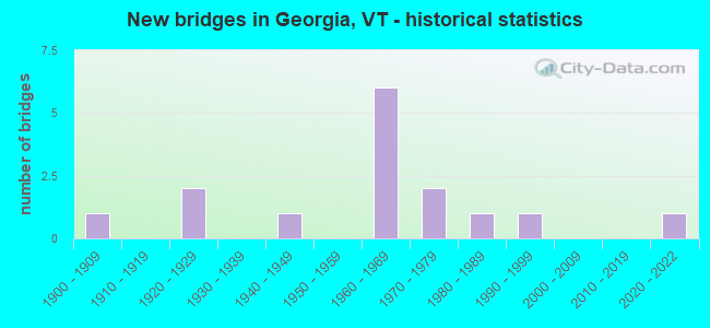
- New bridges - historical statistics
- 11900-1909
- 21920-1929
- 11940-1949
- 61960-1969
- 21970-1979
- 11980-1989
- 11990-1999
- 12020-2022

- Reconstructed bridges - Historical Statistics
- 11960-1969
- 01970-1979
- 01980-1989
- 11990-1999


- Bridge Condition - Deck
- 18.2%Very good
- 54.5%Good
- 27.3%Satisfactory

- Bridge Condition - Superstructure
- 36.4%Very good
- 45.5%Good
- 18.2%Satisfactory

- Bridge Condition - Substructure
- 18.2%Very good
- 45.5%Good
- 27.3%Satisfactory
- 9.1%Fair

- Bridge Condition - Channel
- 42.9%Very good
- 57.1%Good
Find on map >> Show street view
Structure Number: 100608000806081, Location: 0.01 MI TO JCT W CL3 TH9 (Lat: 44.779842, Lng: -73.144039), Route carried "on" structure: Other road C2003, Year Built: 1948, Status: Open, Structure Length: 2.71m (8.89ft), Average Daily Traffic: 1,100 (year 2019), Truck Traffic: 3%, Average Future Daily Traffic: 1,155 (year 2029), Design Load: H 15, Features Intersected: MILL RIVER
Minimum Vertical Clearance: 30+ m (98+ ft), Kilometerpoint: 0.000, Lanes on structure: 2, Owner: Town or Township Highway Agency, Approaching Roadway Width: 7.6m (24.9ft), Material/Design: Steel, Design/Construction: Stringer/Multi-beam, Number Of Spans In Main Unit: 1, Length of Maximum Span: 26.2m (86.0ft), Curb or Sidewalk Widths: Left: 0.2m (0.7ft), Right: 0.2m (0.7ft), Curb-To-Curb Width: 7.3m (24.0ft), Out-to-Out Width: 8.4m (27.6ft)
Condition: Deck: Good, Superstructure: Good, Substructure: Good, Channel: Good, Operating Rating: 48.1 metric tons, Method Used To Determine Operating Rating: Allowable Stress (AS), Inventory Rating: 27.2 metric tons, Method Used To Determine Inventory Rating: Allowable Stress (AS), Structural Evaluation: Equal to present minimum criteria, Deck Geometry: Meets minimum limits, Waterway Adequacy: Better than present minimum criteria, Approach Roadway Alignment: Equal to present desirable criteria, Length Of Structure Improvement: 2.71m (8.89ft), Designated Inspection Frequency: Every 24 months, Inspection Date: July 2020, Bridge Improvement Cost: $854,000, Roadway Improvement Cost: $50,000, Total Project Cost: $904,000 ( Estimate for 2020), Deck Structure Type: Concrete Cast-file-Place
Find on map >> Show street view
Structure Number: 100608000906081, Location: 0.15 MI TO JCT W C3 TH27 (Lat: 44.717514, Lng: -73.165103), Route carried "on" structure: Other road C3043, Year Built: 1994, Status: Open, Structure Length: 1.37m (4.49ft), Average Daily Traffic: 673 (year 2019), Truck Traffic: 2%, Average Future Daily Traffic: 707 (year 2029), Design Load: HS 20, Features Intersected: STONE BRIDGE BROOK
Minimum Vertical Clearance: 30+ m (98+ ft), Kilometerpoint: 0.000, Lanes on structure: 2, Owner: Town or Township Highway Agency, Approaching Roadway Width: 7.6m (24.9ft), Material/Design: Concrete, Design/Construction: Slab, Number Of Spans In Main Unit: 1, Length of Maximum Span: 13.1m (43.0ft), Curb or Sidewalk Widths: Left: 0.2m (0.7ft), Right: 0.2m (0.7ft), Curb-To-Curb Width: 7.7m (25.3ft), Out-to-Out Width: 8.5m (27.9ft)
Condition: Deck: Good, Superstructure: Very good, Substructure: Very good, Channel: Good, Operating Rating: 89.8 metric tons, Method Used To Determine Operating Rating: Load Factor (LF), Inventory Rating: 57.2 metric tons, Method Used To Determine Inventory Rating: Load Factor (LF), Structural Evaluation: Equal to present desirable criteria, Deck Geometry: Meets minimum limits, Waterway Adequacy: Better than present minimum criteria, Approach Roadway Alignment: Better than present minimum criteria, Designated Inspection Frequency: Every 24 months, Inspection Date: July 2020, Deck Structure Type: Concrete Cast-file-Place, Wearing Surface/Protective System: Wearing Surface: Bituminous, Membrane: Preformed Fabric, Deck Protection: Epoxy Coated Reinforcing
Find on map >> Show street view
Structure Number: 100608001006081, Location: 0.1 MI S JCT VT 104A (Lat: 44.679397, Lng: -73.081883), Route carried "on" structure: Other road C2001, Year Built: 1986, Status: Open, Structure Length: 9.81m (32.19ft), Average Daily Traffic: 600 (year 2019), Truck Traffic: 2%, Average Future Daily Traffic: 630 (year 2029), Design Load: HS 20, Features Intersected: LAMOILLE RIVER
Minimum Vertical Clearance: 30+ m (98+ ft), Kilometerpoint: 0.000, Lanes on structure: 2, Owner: Town or Township Highway Agency, Approaching Roadway Width: 8.8m (28.9ft), Material/Design: Steel continuous, Design/Construction: Stringer/Multi-beam, Number Of Spans In Main Unit: 3, Length of Maximum Span: 39.3m (128.9ft), Curb or Sidewalk Widths: Left: 0.2m (0.7ft), Right: 0.2m (0.7ft), Curb-To-Curb Width: 8.1m (26.6ft), Out-to-Out Width: 8.8m (28.9ft)
Condition: Deck: Good, Superstructure: Good, Substructure: Good, Channel: Very good, Operating Rating: 62.6 metric tons, Method Used To Determine Operating Rating: Allowable Stress (AS), Inventory Rating: 35.4 metric tons, Method Used To Determine Inventory Rating: Allowable Stress (AS), Structural Evaluation: Better than present minimum criteria, Deck Geometry: Somewhat better than minimum adequacy, Waterway Adequacy: Equal to present desirable criteria, Approach Roadway Alignment: Equal to present desirable criteria, Designated Inspection Frequency: Every 24 months, Underwater Inspection Frequency: Every 48 months, Inspection Date: July 2020, Underwater Inspection Date: August 2019, Deck Structure Type: Concrete Cast-file-Place, Wearing Surface/Protective System: Wearing Surface: Bituminous, Deck Protection: Epoxy Coated Reinforcing
Find on map >> Show street view
Structure Number: 100608002606081, Location: 0.25 MI TO JCT W CL2 TH3 (Lat: 44.750394, Lng: -73.143669), Route carried "on" structure: Other road C3014, Year Built: 1976, Status: Open, Structure Length: 0.61m (2.00ft), Average Daily Traffic: 400 (year 2019), Truck Traffic: 2%, Average Future Daily Traffic: 420 (year 2029), Design Load: HS 20+Mod, Features Intersected: BROOK
Minimum Vertical Clearance: 30+ m (98+ ft), Kilometerpoint: 0.000, Lanes on structure: 2, Owner: Town or Township Highway Agency, Approaching Roadway Width: 7.3m (24.0ft), Skew: 1 degrees, Material/Design: Concrete, Design/Construction: Culvert, Number Of Spans In Main Unit: 1, Length of Maximum Span: 6.1m (20.0ft), Curb or Sidewalk Widths: Left: 0.1m (0.3ft), Right: 0.1m (0.3ft)
Condition: Channel: Good, Culverts: Very good, Operating Rating: 54.4 metric tons, Method Used To Determine Operating Rating: Field evaluation and documented engineering judgment, Inventory Rating: 32.7 metric tons, Method Used To Determine Inventory Rating: Field evaluation and documented engineering judgment, Structural Evaluation: Equal to present desirable criteria, Waterway Adequacy: Equal to present minimum criteria, Approach Roadway Alignment: Equal to present desirable criteria, Designated Inspection Frequency: Every 24 months, Inspection Date: July 2020, Deck Structure Type: Concrete Cast-file-Place
Find on map >> Show street view
Structure Number: 100608003006081, Location: 0.1 MI TO JCT W CL3 TH9 (Lat: 44.776439, Lng: -73.131836), Route carried "on" structure: Other road C3011, Year Built: 1906, Year Reconstructed: 1990, Status: Open, Structure Length: 1.25m (4.10ft), Average Daily Traffic: 20 (year 2019), Truck Traffic: 2%, Average Future Daily Traffic: 21 (year 2029), Features Intersected: MILL RIVER
Minimum Vertical Clearance: 30+ m (98+ ft), Kilometerpoint: 0.000, Lanes on structure: 1, Owner: Town or Township Highway Agency, Approaching Roadway Width: 3.7m (12.1ft), Material/Design: Steel, Design/Construction: Stringer/Multi-beam, Number Of Spans In Main Unit: 1, Length of Maximum Span: 11.9m (39.0ft), Curb-To-Curb Width: 4.5m (14.8ft), Out-to-Out Width: 4.9m (16.1ft)
Condition: Deck: Satisfactory, Superstructure: Satisfactory, Substructure: Satisfactory, Channel: Very good, Operating Rating: 53.5 metric tons, Method Used To Determine Operating Rating: Allowable Stress (AS), Inventory Rating: 39.9 metric tons, Method Used To Determine Inventory Rating: Allowable Stress (AS), Structural Evaluation: Equal to present minimum criteria, Deck Geometry: Equal to present minimum criteria, Waterway Adequacy: Better than present minimum criteria, Approach Roadway Alignment: Equal to present minimum criteria, Length Of Structure Improvement: 1.25m (4.10ft), Designated Inspection Frequency: Every 24 months, Inspection Date: July 2020, Bridge Improvement Cost: $231,000, Roadway Improvement Cost: $50,000, Total Project Cost: $281,000 ( Estimate for 2020), Deck Structure Type: Wood or Timber
Find on map >> Show street view
Structure Number: 200023000106082, Location: 1.1 MI E JCT. U.S.7 (Lat: 44.683142, Lng: -73.092394), Route carried "on" structure: Alternate State highway 104A, Year Built: 2020, Status: Open, Structure Length: 2.87m (9.42ft), Average Daily Traffic: 3,500 (year 2018), Truck Traffic: 3%, Average Future Daily Traffic: 6,200 (year 2041), Design Load: HL 93, Features Intersected: ARROW HEAD LAKE
Minimum Vertical Clearance: 30+ m (98+ ft), Kilometerpoint: 26.991, Lanes on structure: 2, Base Highway Network: Yes, Owner: State Highway Agency, Approaching Roadway Width: 8.5m (27.9ft), Material/Design: Steel, Design/Construction: Stringer/Multi-beam, Number Of Spans In Main Unit: 1, Length of Maximum Span: 27.4m (89.9ft), Curb-To-Curb Width: 8.5m (27.9ft), Out-to-Out Width: 9.5m (31.2ft)
Condition: Deck: Very good, Superstructure: Very good, Substructure: Very good, Channel: Very good, Operating Rating: 56.2 metric tons, Method Used To Determine Operating Rating: Load and Resistance Factor (LRFR), Inventory Rating: 43.5 metric tons, Method Used To Determine Inventory Rating: Load and Resistance Factor (LRFR), Structural Evaluation: Equal to present desirable criteria, Deck Geometry: Meets minimum limits, Waterway Adequacy: Equal to present minimum criteria, Approach Roadway Alignment: Equal to present desirable criteria, Length Of Structure Improvement: 2.87m (9.42ft), Designated Inspection Frequency: Every 24 months, Inspection Date: August 2021, Bridge Improvement Cost: $1,030,000, Roadway Improvement Cost: $50,000, Total Project Cost: $1,080,000 ( Estimate for 2020), Deck Structure Type: Other, Wearing Surface/Protective System: Deck Protection: Other
Find on map >> Show street view
Structure Number: 200089084N06082, Location: 0.8 MI S EXIT 18 (Lat: 44.692969, Lng: -73.122050), Route carried "on" structure: Interstate 89, Year Built: 1967, Status: Open, Structure Length: 2.87m (9.42ft), Average Daily Traffic: 23,400 (year 2018), Truck Traffic: 13%, Average Future Daily Traffic: 24,570 (year 2028), Design Load: HS 20, Features Intersected: I 89 OVER TH NO 6
Minimum Vertical Clearance: 30+ m (98+ ft), Kilometerpoint: 170.023, Lanes on structure: 2, Lanes under structure: 2, Base Highway Network: Yes, Owner: State Highway Agency, Approaching Roadway Width: 11.6m (38.1ft), Skew: 13 degrees, Material/Design: Steel, Design/Construction: Stringer/Multi-beam, Number Of Spans In Main Unit: 2, Length of Maximum Span: 28.0m (91.9ft), Curb or Sidewalk Widths: Left: 0.2m (0.7ft), Right: 0.2m (0.7ft), Curb-To-Curb Width: 11.4m (37.4ft), Out-to-Out Width: 12.9m (42.3ft)
Condition: Deck: Good, Superstructure: Very good, Substructure: Good, Operating Rating: 89.8 metric tons, Method Used To Determine Operating Rating: Load Factor (LF), Inventory Rating: 57.2 metric tons, Method Used To Determine Inventory Rating: Load Factor (LF), Structural Evaluation: Better than present minimum criteria, Deck Geometry: Somewhat better than minimum adequacy, Underclear: Meets minimum limits, Approach Roadway Alignment: Equal to present desirable criteria, Designated Inspection Frequency: Every 24 months, Inspection Date: June 2020, Deck Structure Type: Concrete Cast-file-Place, Wearing Surface/Protective System: Wearing Surface: Bituminous, Membrane: Preformed Fabric
Find on map >> Show street view
Structure Number: 200089084S06082, Location: 0.8 MI S EXIT 18 (Lat: 44.693217, Lng: -73.122622), Route carried "on" structure: Interstate 89, Year Built: 1967, Status: Open, Structure Length: 2.87m (9.42ft), Average Daily Traffic: 23,400 (year 2018), Truck Traffic: 13%, Average Future Daily Traffic: 24,570 (year 2028), Design Load: H 15, Features Intersected: I 89 OVER TH NO 6
Minimum Vertical Clearance: 30+ m (98+ ft), Kilometerpoint: 170.023, Lanes on structure: 2, Lanes under structure: 2, Base Highway Network: Yes, Owner: State Highway Agency, Approaching Roadway Width: 11.6m (38.1ft), Skew: 12 degrees, Material/Design: Steel, Design/Construction: Stringer/Multi-beam, Number Of Spans In Main Unit: 1, Length of Maximum Span: 27.7m (90.9ft), Curb or Sidewalk Widths: Left: 0.2m (0.7ft), Right: 0.2m (0.7ft), Curb-To-Curb Width: 11.4m (37.4ft), Out-to-Out Width: 12.9m (42.3ft)
Condition: Deck: Very good, Superstructure: Very good, Substructure: Good, Operating Rating: 89.8 metric tons, Method Used To Determine Operating Rating: Load Factor (LF), Inventory Rating: 57.2 metric tons, Method Used To Determine Inventory Rating: Load Factor (LF), Structural Evaluation: Better than present minimum criteria, Deck Geometry: Somewhat better than minimum adequacy, Underclear: Equal to present minimum criteria, Approach Roadway Alignment: Equal to present desirable criteria, Designated Inspection Frequency: Every 24 months, Inspection Date: June 2020, Deck Structure Type: Concrete Cast-file-Place, Wearing Surface/Protective System: Wearing Surface: Bituminous, Membrane: Preformed Fabric
Find on map >> Show street view
Structure Number: 200089086N06082, Location: 1.0 MI N EXIT 18 (Lat: 44.705853, Lng: -73.090844), Route carried "on" structure: Interstate 89, Year Built: 1967, Status: Open, Structure Length: 22.92m (75.20ft), Average Daily Traffic: 22,000 (year 2018), Truck Traffic: 13%, Average Future Daily Traffic: 23,100 (year 2028), Design Load: HS 20, Features Intersected: I 89 OVER NECRR
Minimum Vertical Clearance: 30+ m (98+ ft), Kilometerpoint: 172.903, Lanes on structure: 2, Base Highway Network: Yes, Owner: State Highway Agency, Approaching Roadway Width: 11.6m (38.1ft), Skew: 10 degrees, Material/Design: Steel, Design/Construction: Stringer/Multi-beam, Number Of Spans In Main Unit: 8, Length of Maximum Span: 28.0m (91.9ft), Curb or Sidewalk Widths: Left: 0.5m (1.6ft), Right: 0.5m (1.6ft), Curb-To-Curb Width: 9.1m (29.9ft), Out-to-Out Width: 10.8m (35.4ft)
Condition: Deck: Good, Superstructure: Good, Substructure: Satisfactory, Operating Rating: 89.8 metric tons, Method Used To Determine Operating Rating: Load Factor (LF), Inventory Rating: 57.2 metric tons, Method Used To Determine Inventory Rating: Load Factor (LF), Structural Evaluation: Equal to present minimum criteria, Deck Geometry: Meets minimum limits, Underclear: Superior to present desirable criteria, Approach Roadway Alignment: Equal to present desirable criteria, Designated Inspection Frequency: Every 24 months, Inspection Date: June 2020, Deck Structure Type: Concrete Cast-file-Place, Wearing Surface/Protective System: Wearing Surface: Bituminous, Membrane: Preformed Fabric
Find on map >> Show street view
Structure Number: 200089086S06082, Location: 1.0 MI N EXIT 18 (Lat: 44.705986, Lng: -73.091056), Route carried "on" structure: Interstate 89, Year Built: 1967, Status: Open, Structure Length: 25.79m (84.61ft), Average Daily Traffic: 22,000 (year 2018), Truck Traffic: 13%, Average Future Daily Traffic: 23,100 (year 2028), Design Load: HS 20, Features Intersected: I 89 OVER NECRR
Minimum Vertical Clearance: 30+ m (98+ ft), Kilometerpoint: 172.903, Lanes on structure: 2, Base Highway Network: Yes, Owner: State Highway Agency, Approaching Roadway Width: 11.6m (38.1ft), Skew: 10 degrees, Material/Design: Steel, Design/Construction: Stringer/Multi-beam, Number Of Spans In Main Unit: 9, Length of Maximum Span: 28.0m (91.9ft), Curb or Sidewalk Widths: Left: 0.5m (1.6ft), Right: 0.5m (1.6ft), Curb-To-Curb Width: 9.1m (29.9ft), Out-to-Out Width: 10.8m (35.4ft)
Condition: Deck: Satisfactory, Superstructure: Good, Substructure: Satisfactory, Operating Rating: 89.8 metric tons, Method Used To Determine Operating Rating: Load Factor (LF), Inventory Rating: 57.2 metric tons, Method Used To Determine Inventory Rating: Load Factor (LF), Structural Evaluation: Equal to present minimum criteria, Deck Geometry: Meets minimum limits, Underclear: Superior to present desirable criteria, Approach Roadway Alignment: Equal to present desirable criteria, Designated Inspection Frequency: Every 24 months, Inspection Date: June 2020, Deck Structure Type: Concrete Cast-file-Place, Wearing Surface/Protective System: Wearing Surface: Bituminous, Membrane: Preformed Fabric
Find on map >> Show street view
Structure Number: 200285015704052, Location: 1.0 MI N JCT. VT.2A (Lat: 44.565650, Lng: -73.157356), Route carried "on" structure: US 7, Year Built: 1924, Year Reconstructed: 1969, Status: Open, Structure Length: 1.04m (3.41ft), Average Daily Traffic: 12,100 (year 2018), Truck Traffic: 6%, Average Future Daily Traffic: 12,705 (year 2028), Design Load: H 15, Features Intersected: MALLETTS CREEK
Minimum Vertical Clearance: 30+ m (98+ ft), Kilometerpoint: 226.599, Lanes on structure: 2, Base Highway Network: Yes, Owner: State Highway Agency, Approaching Roadway Width: 9.4m (30.8ft), Material/Design: Concrete, Design/Construction: Tee Beam, Number Of Spans In Main Unit: 1, Length of Maximum Span: 9.1m (29.9ft), Curb-To-Curb Width: 9.4m (30.8ft), Out-to-Out Width: 10.5m (34.4ft)
Condition: Deck: Satisfactory, Superstructure: Satisfactory, Substructure: Fair, Channel: Good, Operating Rating: 51.7 metric tons, Method Used To Determine Operating Rating: Load Factor (LF), Inventory Rating: 30.8 metric tons, Method Used To Determine Inventory Rating: Load Factor (LF), Structural Evaluation: Somewhat better than minimum adequacy, Deck Geometry: High priority of corrective action, Waterway Adequacy: Somewhat better than minimum adequacy, Approach Roadway Alignment: Equal to present desirable criteria, Length Of Structure Improvement: 1.04m (3.41ft), Designated Inspection Frequency: Every 24 months, Inspection Date: May 2021, Bridge Improvement Cost: $408,000, Roadway Improvement Cost: $50,000, Total Project Cost: $458,000 ( Estimate for 2020), Deck Structure Type: Concrete Cast-file-Place, Wearing Surface/Protective System: Wearing Surface: Bituminous
Find on map >> Show street view
Structure Number: 200285163A06082, Location: 0.3 MI N JCT VT 104A (Lat: 44.699089, Lng: -73.106403), Route carried "on" structure: US 7, Year Built: 1968, Status: Open, Structure Length: 9.30m (30.51ft), Average Daily Traffic: 7,500 (year 2018), Truck Traffic: 6%, Average Future Daily Traffic: 7,875 (year 2028), Design Load: HS 20, Features Intersected: I 89 UNDER US 7
Minimum Vertical Clearance: 30+ m (98+ ft), Kilometerpoint: 245.086, Lanes on structure: 2, Lanes under structure: 6, Owner: State Highway Agency, Approaching Roadway Width: 13.7m (44.9ft), Skew: 3 degrees, Material/Design: Steel continuous, Design/Construction: Stringer/Multi-beam, Number Of Spans In Main Unit: 4, Length of Maximum Span: 27.4m (89.9ft), Curb or Sidewalk Widths: Left: 0.5m (1.6ft), Right: 0.5m (1.6ft), Curb-To-Curb Width: 11.6m (38.1ft), Out-to-Out Width: 13.3m (43.6ft)
Condition: Deck: Good, Superstructure: Good, Substructure: Good, Operating Rating: 61.7 metric tons, Method Used To Determine Operating Rating: Allowable Stress (AS), Inventory Rating: 34.5 metric tons, Method Used To Determine Inventory Rating: Allowable Stress (AS), Structural Evaluation: Better than present minimum criteria, Deck Geometry: Somewhat better than minimum adequacy, Underclear: High priority of corrective action, Approach Roadway Alignment: Equal to present desirable criteria, Designated Inspection Frequency: Every 24 months, Inspection Date: June 2020, Deck Structure Type: Concrete Cast-file-Place, Wearing Surface/Protective System: Wearing Surface: Bituminous, Membrane: Preformed Fabric
Find on map >> Show street view
Structure Number: 100608000706081, Location: 0.1 MI TO JCT VT 104A (Lat: 44.678744, Lng: -73.083189), Route carried "under" structure: Other road C2001, Year Built: 1925, Structure Length: 0. m, Average Daily Traffic: 600 (year 1998), Truck Traffic: 2%, Features Intersected: NEW ENGLAND CENTRAL RR, Facility Carried by Structure: RAILROAD
Kilometerpoint: 0.000, Material/Design: Steel, Design/Construction: Girder and Floorbeam System, Length of Maximum Span: 18.9m (62.0ft)
Find on map >> Show street view
Structure Number: 200023000206082, Location: 1.7 MI E JCT. U.S.7 (Lat: 44.680233, Lng: -73.083347), Route carried "under" structure: Alternate State highway 104A, Year Built: 1974, Structure Length: 0. m, Average Daily Traffic: 3,800 (year 1998), Features Intersected: NECRR OVER VT 104A, Facility Carried by Structure: RAILROAD
Kilometerpoint: 27.852, Material/Design: Steel, Design/Construction: Stringer/Multi-beam, Length of Maximum Span: 30.5m (100.1ft)
Find on map >> Show street view
Structure Number: 200285163A06082, Location: 0.3 MI N JCT VT 104A (Lat: 44.699089, Lng: -73.106403), Route carried "under" structure: Interstate 89, Year Built: 1967, Structure Length: 0. m, Average Daily Traffic: 16,800 (year 1998), Truck Traffic: 13%, Features Intersected: I 89 UNDER US 7, Facility Carried by Structure: US 00007 ML
Minimum Vertical Clearance: 5.41m (17.75ft), Kilometerpoint: 275.898, Lanes on structure: 2, Material/Design: Steel continuous, Design/Construction: Stringer/Multi-beam, Length of Maximum Span: 27.4m (89.9ft)