Bridge Statistics for Georgiana, Alabama (AL)
Condition, Traffic, Stress, Structural Evaluation, Project Costs
- National Bridge Inventory (NBI) Statistics
- 32Number of bridges
- 394ft / 120mTotal length
- $43,056,000Total costs
- 191,724Total average daily traffic
- 44,418Total average daily truck traffic
- National Bridge Inventory (NBI) Registered Bridges for Georgiana
- No street view available for this location
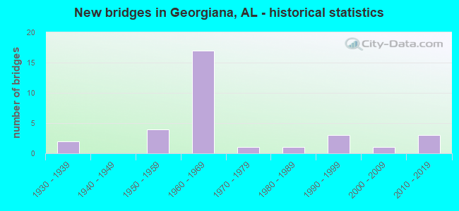
- New bridges - historical statistics
- 21930-1939
- 41950-1959
- 171960-1969
- 11970-1979
- 11980-1989
- 31990-1999
- 12000-2009
- 32010-2019


- Bridge Condition - Deck
- 41.2%Good
- 52.9%Satisfactory
- 5.9%Fair

- Bridge Condition - Superstructure
- 11.8%Very good
- 29.4%Good
- 47.1%Satisfactory
- 11.8%Fair

- Bridge Condition - Substructure
- 11.8%Very good
- 41.2%Good
- 41.2%Satisfactory
- 5.9%Fair

- Bridge Condition - Channel
- 9.1%Very good
- 36.4%Good
- 36.4%Satisfactory
- 18.2%Fair

- Bridge Condition - Culverts
- 9.1%Good
- 90.9%Satisfactory
Find on map >> Show street view
Structure Number: 879, Location: 0.4 MI N OF GEORGIANA (Lat: 31.648014, Lng: -86.724000), Route carried "on" structure: US 31, Year Built: 1931, Status: Open, Structure Length: 1.34m (4.40ft), Average Daily Traffic: 2,760 (year 2013), Truck Traffic: 12%, Average Future Daily Traffic: 3,545 (year 2033), Design Load: H 15, Features Intersected: STREAM
Minimum Vertical Clearance: 30+ m (98+ ft), Kilometerpoint: 199.197, Lanes on structure: 2, Owner: State Highway Agency, Approaching Roadway Width: 9.8m (32.2ft), Material/Design: Concrete continuous, Design/Construction: Culvert, Number Of Spans In Main Unit: 4, Length of Maximum Span: 3.0m (9.8ft), Curb-To-Curb Width: 8.2m (26.9ft), Out-to-Out Width: 8.5m (27.9ft)
Condition: Channel: Satisfactory, Culverts: Satisfactory, Operating Rating: 43.5 metric tons, Method Used To Determine Operating Rating: Field evaluation and documented engineering judgment, Inventory Rating: 32.7 metric tons, Method Used To Determine Inventory Rating: Field evaluation and documented engineering judgment, Structural Evaluation: Equal to present minimum criteria, Deck Geometry: High priority of corrective action, Waterway Adequacy: Better than present minimum criteria, Approach Roadway Alignment: Better than present minimum criteria, Length Of Structure Improvement: 2.02m (6.63ft), Designated Inspection Frequency: Every 24 months, Inspection Date: July 2021, Bridge Improvement Cost: $326,000, Roadway Improvement Cost: $33,000, Total Project Cost: $359,000 ( Estimate for 2022)
Find on map >> Show street view
Structure Number: 881, Location: 1.1 MI N. AL 106 (Lat: 31.653128, Lng: -86.715506), Route carried "on" structure: US 31, Year Built: 1931, Status: Open, Structure Length: 9.39m (30.81ft), Average Daily Traffic: 2,760 (year 2013), Truck Traffic: 12%, Average Future Daily Traffic: 3,545 (year 2033), Design Load: H 15, Features Intersected: ROCKY CREEK
Minimum Vertical Clearance: 30+ m (98+ ft), Kilometerpoint: 199.666, Lanes on structure: 2, Owner: State Highway Agency, Approaching Roadway Width: 9.1m (29.9ft), Material/Design: Concrete, Design/Construction: Tee Beam, Number Of Spans In Main Unit: 8, Length of Maximum Span: 11.6m (38.1ft), Curb-To-Curb Width: 7.3m (24.0ft), Out-to-Out Width: 7.6m (24.9ft)
Condition: Deck: Satisfactory, Superstructure: Satisfactory, Substructure: Fair, Channel: Satisfactory, Operating Rating: 50.7 metric tons, Method Used To Determine Operating Rating: Load Factor (LF), Inventory Rating: 30.4 metric tons, Method Used To Determine Inventory Rating: Load Factor (LF), Structural Evaluation: Somewhat better than minimum adequacy, Deck Geometry: High priority of replacement, Waterway Adequacy: Better than present minimum criteria, Approach Roadway Alignment: Better than present minimum criteria, Length Of Structure Improvement: 10.35m (33.96ft), Designated Inspection Frequency: Every 24 months, Inspection Date: July 2021, Bridge Improvement Cost: $1,703,000, Roadway Improvement Cost: $170,000, Total Project Cost: $1,873,000 ( Estimate for 2022), Deck Structure Type: Concrete Cast-file-Place, Wearing Surface/Protective System: Wearing Surface: Bituminous
Find on map >> Show street view
Structure Number: 458, Location: 1.0 MI.W.GEORGIANA (Lat: 31.628817, Lng: -86.775550), Route carried "on" structure: County highway 16, Year Built: 1992, Status: Open, Structure Length: 0.92m (3.02ft), Average Daily Traffic: 260 (year 2018), Truck Traffic: 2%, Average Future Daily Traffic: 230 (year 2041), Design Load: HS 20, Features Intersected: BRANCH OF PANTHER CREEK
Minimum Vertical Clearance: 30+ m (98+ ft), Kilometerpoint: 0.010, Lanes on structure: 2, Owner: County Highway Agency, Approaching Roadway Width: 7.3m (24.0ft), Material/Design: Wood or Timber, Design/Construction: Stringer/Multi-beam, Number Of Spans In Main Unit: 1, Length of Maximum Span: 9.2m (30.2ft), Curb-To-Curb Width: 7.3m (24.0ft), Out-to-Out Width: 7.5m (24.6ft)
Condition: Deck: Good, Superstructure: Good, Substructure: Good, Channel: Good, Operating Rating: 41.9 metric tons, Method Used To Determine Operating Rating: Allowable Stress (AS), Inventory Rating: 29.8 metric tons, Method Used To Determine Inventory Rating: Allowable Stress (AS), Structural Evaluation: Better than present minimum criteria, Deck Geometry: Somewhat better than minimum adequacy, Waterway Adequacy: Equal to present desirable criteria, Approach Roadway Alignment: Equal to present minimum criteria, Length Of Structure Improvement: 1.59m (5.22ft), Designated Inspection Frequency: Every 24 months, Inspection Date: Febuary 2021, Bridge Improvement Cost: $262,000, Roadway Improvement Cost: $26,000, Total Project Cost: $288,000 ( Estimate for 2022), Deck Structure Type: Wood or Timber, Wearing Surface/Protective System: Wearing Surface: Bituminous, Membrane: Preformed Fabric
Find on map >> Show street view
Structure Number: 4836, Location: BETWEEN GEORGIANA *AVANT (Lat: 31.626267, Lng: -86.712233), Route carried "on" structure: County highway 16, Year Built: 1954, Status: Posted for load, Structure Length: 3.11m (10.20ft), Average Daily Traffic: 260 (year 2018), Truck Traffic: 16%, Average Future Daily Traffic: 500 (year 2041), Design Load: H 15, Features Intersected: ROCKY CREEK
Minimum Vertical Clearance: 30+ m (98+ ft), Kilometerpoint: 0.010, Lanes on structure: 2, Owner: County Highway Agency, Approaching Roadway Width: 8.5m (27.9ft), Material/Design: Concrete, Design/Construction: Tee Beam, Number Of Spans In Main Unit: 3, Length of Maximum Span: 10.4m (34.1ft), Curb-To-Curb Width: 6.7m (22.0ft), Out-to-Out Width: 7.2m (23.6ft)
Condition: Deck: Good, Superstructure: Good, Substructure: Good, Channel: Good, Operating Rating: 36.2 metric tons, Method Used To Determine Operating Rating: Load Factor (LF), Inventory Rating: 21.2 metric tons, Method Used To Determine Inventory Rating: Load Factor (LF), Structural Evaluation: Equal to present minimum criteria, Deck Geometry: Meets minimum limits, Waterway Adequacy: Equal to present desirable criteria, Approach Roadway Alignment: Equal to present minimum criteria, Bridge Posting: Required (Relationship of Operating Rating to Maximum Legal Load: 0.1 - 9.9% below), Length Of Structure Improvement: 3.96m (12.99ft), Designated Inspection Frequency: Every 24 months, Other Special Inspection Frequency: Every 12 months, Inspection Date: January 2021, Other Special Inspection Date: January 2022, Bridge Improvement Cost: $625,000, Roadway Improvement Cost: $63,000, Total Project Cost: $688,000 ( Estimate for 2022), Deck Structure Type: Concrete Cast-file-Place
Find on map >> Show street view
Structure Number: 5079, Location: 03.5 MI N OF MCKENZIE (Lat: 31.596667, Lng: -86.735000), Route carried "on" structure: ServiceUS 31, Year Built: 1955, Status: Closed, Structure Length: 0.64m (2.10ft), Average Daily Traffic: 4,520 (year 2011), Truck Traffic: 15%, Average Future Daily Traffic: 7,410 (year 2031), Design Load: H 15, Features Intersected: STREAM
Minimum Vertical Clearance: 30+ m (98+ ft), Kilometerpoint: 192.650, Lanes on structure: 2, Owner: State Highway Agency, Approaching Roadway Width: 15.2m (49.9ft), Material/Design: Concrete continuous, Design/Construction: Culvert, Number Of Spans In Main Unit: 2, Length of Maximum Span: 3.0m (9.8ft)
Condition: Channel: Good, Culverts: Satisfactory, Waterway Adequacy: Better than present minimum criteria, Approach Roadway Alignment: Better than present minimum criteria, Bridge Posting: Required (Relationship of Operating Rating to Maximum Legal Load: > 39.9% below), Length Of Structure Improvement: 1.26m (4.13ft), Designated Inspection Frequency: Every 24 months, Inspection Date: July 2021, Bridge Improvement Cost: $502,000, Roadway Improvement Cost: $50,000, Total Project Cost: $552,000 ( Estimate for 2022)
Find on map >> Show street view
Structure Number: 6373, Location: 2.2 MI E OF JCT I 65 (Lat: 31.643686, Lng: -86.738828), Route carried "on" structure: State highway 106, Year Built: 1958, Status: Open, Structure Length: 6.83m (22.41ft), Average Daily Traffic: 6,380 (year 2013), Truck Traffic: 8%, Average Future Daily Traffic: 7,482 (year 2033), Design Load: H 20, Features Intersected: L*N RR * RAIL RD AVE
Minimum Vertical Clearance: 30+ m (98+ ft), Kilometerpoint: 19.528, Lanes on structure: 2, Lanes under structure: 2, Owner: State Highway Agency, Approaching Roadway Width: 14.6m (47.9ft), Material/Design: Concrete, Design/Construction: Tee Beam, Number Of Spans In Main Unit: 7, Length of Maximum Span: 9.8m (32.2ft), Curb or Sidewalk Widths: Left: 1.2m (3.9ft), Right: 1.2m (3.9ft), Curb-To-Curb Width: 8.5m (27.9ft), Out-to-Out Width: 11.0m (36.1ft)
Condition: Deck: Satisfactory, Superstructure: Satisfactory, Substructure: Satisfactory, Operating Rating: 50.6 metric tons, Method Used To Determine Operating Rating: Load Factor (LF), Inventory Rating: 30.3 metric tons, Method Used To Determine Inventory Rating: Load Factor (LF), Structural Evaluation: Equal to present minimum criteria, Deck Geometry: Meets minimum limits, Underclear: Meets minimum limits, Approach Roadway Alignment: Equal to present minimum criteria, Length Of Structure Improvement: 7.87m (25.82ft), Designated Inspection Frequency: Every 24 months, Inspection Date: August 2020, Bridge Improvement Cost: $1,942,000, Roadway Improvement Cost: $194,000, Total Project Cost: $2,136,000 ( Estimate for 2022), Deck Structure Type: Concrete Cast-file-Place
Find on map >> Show street view
Structure Number: 6783, Location: 6.1 MI.N.OF CONECUH CO (Lat: 31.626217, Lng: -86.799664), Route carried "on" structure: County highway 16, Year Built: 1960, Status: Open, Structure Length: 10.67m (35.01ft), Average Daily Traffic: 600 (year 2005), Truck Traffic: 5%, Average Future Daily Traffic: 1,300 (year 2030), Design Load: H 20, Features Intersected: I65
Minimum Vertical Clearance: 30+ m (98+ ft), Kilometerpoint: 2.359, Lanes on structure: 2, Lanes under structure: 4, Owner: State Highway Agency, Approaching Roadway Width: 9.1m (29.9ft), Skew: 4 degrees, Material/Design: Concrete continuous, Design/Construction: Tee Beam, Number Of Spans In Main Unit: 4, Length of Maximum Span: 29.3m (96.1ft), Curb-To-Curb Width: 7.3m (24.0ft), Out-to-Out Width: 8.8m (28.9ft)
Condition: Deck: Satisfactory, Superstructure: Fair, Substructure: Satisfactory, Operating Rating: 65.0 metric tons, Method Used To Determine Operating Rating: Load Factor (LF), Inventory Rating: 38.9 metric tons, Method Used To Determine Inventory Rating: Load Factor (LF), Structural Evaluation: Somewhat better than minimum adequacy, Deck Geometry: Meets minimum limits, Underclear: Meets minimum limits, Approach Roadway Alignment: Better than present minimum criteria, Length Of Structure Improvement: 11.57m (37.96ft), Designated Inspection Frequency: Every 24 months, Inspection Date: December 2020, Bridge Improvement Cost: $2,222,000, Roadway Improvement Cost: $222,000, Total Project Cost: $2,444,000 ( Estimate for 2022), Deck Structure Type: Concrete Cast-file-Place
Find on map >> Show street view
Structure Number: 6784, Location: 2.4 MI.N.OF CO 15 (Lat: 31.625433, Lng: -86.800917), Route carried "on" structure: Interstate 65, Year Built: 1960, Status: Open, Structure Length: 1.13m (3.71ft), Average Daily Traffic: 23,470 (year 2013), Truck Traffic: 27%, Average Future Daily Traffic: 29,735 (year 2033), Design Load: HS 20, Features Intersected: STREAM
Minimum Vertical Clearance: 30+ m (98+ ft), Kilometerpoint: 179.707, Lanes on structure: 4, Base Highway Network: Yes, Owner: State Highway Agency, Approaching Roadway Width: 24.4m (80.1ft), Skew: 13 degrees, Material/Design: Concrete continuous, Design/Construction: Culvert, Number Of Spans In Main Unit: 3, Length of Maximum Span: 3.0m (9.8ft)
Condition: Channel: Satisfactory, Culverts: Satisfactory, Operating Rating: 88.9 metric tons, Method Used To Determine Operating Rating: Load Factor (LF), Inventory Rating: 88.9 metric tons, Method Used To Determine Inventory Rating: Load Factor (LF), Structural Evaluation: Equal to present minimum criteria, Waterway Adequacy: Equal to present minimum criteria, Approach Roadway Alignment: Equal to present minimum criteria, Length Of Structure Improvement: 1.81m (5.94ft), Designated Inspection Frequency: Every 24 months, Inspection Date: December 2020, Bridge Improvement Cost: $1,877,000, Roadway Improvement Cost: $188,000, Total Project Cost: $2,065,000 ( Estimate for 2022)
Find on map >> Show street view
Structure Number: 6785, Location: 1.4 MI.N.OF CO.16 (Lat: 31.641067, Lng: -86.785308), Route carried "on" structure: Interstate 65, Year Built: 1960, Status: Open, Structure Length: 1.16m (3.81ft), Average Daily Traffic: 23,470 (year 2013), Truck Traffic: 27%, Average Future Daily Traffic: 29,735 (year 2033), Design Load: HS 20, Features Intersected: STREAM
Minimum Vertical Clearance: 30+ m (98+ ft), Kilometerpoint: 181.970, Lanes on structure: 4, Base Highway Network: Yes, Owner: State Highway Agency, Approaching Roadway Width: 24.4m (80.1ft), Skew: 13 degrees, Material/Design: Concrete continuous, Design/Construction: Culvert, Number Of Spans In Main Unit: 3, Length of Maximum Span: 3.7m (12.1ft)
Condition: Channel: Fair, Culverts: Satisfactory, Operating Rating: 88.9 metric tons, Method Used To Determine Operating Rating: Load Factor (LF), Inventory Rating: 88.9 metric tons, Method Used To Determine Inventory Rating: Load Factor (LF), Structural Evaluation: Equal to present minimum criteria, Waterway Adequacy: Equal to present minimum criteria, Approach Roadway Alignment: Better than present minimum criteria, Length Of Structure Improvement: 1.84m (6.04ft), Designated Inspection Frequency: Every 24 months, Inspection Date: December 2020, Bridge Improvement Cost: $1,962,000, Roadway Improvement Cost: $196,000, Total Project Cost: $2,158,000 ( Estimate for 2022)
Find on map >> Show street view
Structure Number: 7119, Location: INT. AL106 * I-65 (Lat: 31.650544, Lng: -86.774817), Route carried "on" structure: State highway 106, Year Built: 1960, Status: Open, Structure Length: 8.08m (26.51ft), Average Daily Traffic: 1,510 (year 2013), Truck Traffic: 20%, Average Future Daily Traffic: 1,771 (year 2033), Design Load: H 20, Features Intersected: I-65
Minimum Vertical Clearance: 30+ m (98+ ft), Kilometerpoint: 15.846, Lanes on structure: 2, Lanes under structure: 4, Owner: State Highway Agency, Approaching Roadway Width: 9.8m (32.2ft), Material/Design: Concrete continuous, Design/Construction: Tee Beam, Number Of Spans In Main Unit: 4, Length of Maximum Span: 22.3m (73.2ft), Curb-To-Curb Width: 7.3m (24.0ft), Out-to-Out Width: 8.2m (26.9ft)
Condition: Deck: Fair, Superstructure: Satisfactory, Substructure: Satisfactory, Operating Rating: 42.5 metric tons, Method Used To Determine Operating Rating: Load Factor (LF), Inventory Rating: 25.5 metric tons, Method Used To Determine Inventory Rating: Load Factor (LF), Structural Evaluation: Equal to present minimum criteria, Deck Geometry: Meets minimum limits, Underclear: Equal to present minimum criteria, Approach Roadway Alignment: Equal to present minimum criteria, Length Of Structure Improvement: 9.08m (29.79ft), Designated Inspection Frequency: Every 24 months, Inspection Date: October 2020, Bridge Improvement Cost: $1,620,000, Roadway Improvement Cost: $162,000, Total Project Cost: $1,782,000 ( Estimate for 2022), Deck Structure Type: Concrete Cast-file-Place
Find on map >> Show street view
Structure Number: 8319, Location: CHAPMAN (Lat: 31.667319, Lng: -86.716667), Route carried "on" structure: County highway 37, Year Built: 1964, Status: Posted for load, Structure Length: 4.15m (13.62ft), Average Daily Traffic: 309 (year 2018), Truck Traffic: 32%, Average Future Daily Traffic: 600 (year 2041), Design Load: H 20, Features Intersected: ROCKY CREEK
Minimum Vertical Clearance: 30+ m (98+ ft), Kilometerpoint: 0.010, Lanes on structure: 2, Owner: County Highway Agency, Approaching Roadway Width: 9.1m (29.9ft), Material/Design: Concrete, Design/Construction: Tee Beam, Number Of Spans In Main Unit: 4, Length of Maximum Span: 10.4m (34.1ft), Curb-To-Curb Width: 7.3m (24.0ft), Out-to-Out Width: 8.9m (29.2ft)
Condition: Deck: Satisfactory, Superstructure: Satisfactory, Substructure: Good, Channel: Good, Operating Rating: 41.7 metric tons, Method Used To Determine Operating Rating: Load Factor (LF), Inventory Rating: 24.5 metric tons, Method Used To Determine Inventory Rating: Load Factor (LF), Structural Evaluation: Equal to present minimum criteria, Deck Geometry: Somewhat better than minimum adequacy, Waterway Adequacy: Equal to present desirable criteria, Approach Roadway Alignment: Equal to present minimum criteria, Bridge Posting: Required (Relationship of Operating Rating to Maximum Legal Load: 10.0 - 19.9% below), Length Of Structure Improvement: 5.12m (16.80ft), Designated Inspection Frequency: Every 24 months, Other Special Inspection Frequency: Every 12 months, Inspection Date: January 2021, Other Special Inspection Date: January 2022, Bridge Improvement Cost: $1,018,000, Roadway Improvement Cost: $102,000, Total Project Cost: $1,120,000 ( Estimate for 2022), Deck Structure Type: Concrete Cast-file-Place
Find on map >> Show street view
Structure Number: 832, Location: CHAPMAN (Lat: 31.667372, Lng: -86.714842), Route carried "on" structure: County highway 37, Year Built: 1964, Status: Posted for load, Structure Length: 5.20m (17.06ft), Average Daily Traffic: 309 (year 2018), Truck Traffic: 32%, Average Future Daily Traffic: 600 (year 2041), Design Load: H 20, Features Intersected: ROCKY CREEK RELIEF
Minimum Vertical Clearance: 30+ m (98+ ft), Kilometerpoint: 0.010, Lanes on structure: 2, Owner: County Highway Agency, Approaching Roadway Width: 9.1m (29.9ft), Material/Design: Concrete, Design/Construction: Tee Beam, Number Of Spans In Main Unit: 4, Length of Maximum Span: 10.4m (34.1ft), Curb-To-Curb Width: 7.3m (24.0ft), Out-to-Out Width: 8.9m (29.2ft)
Condition: Deck: Good, Superstructure: Good, Substructure: Good, Channel: Good, Operating Rating: 40.8 metric tons, Method Used To Determine Operating Rating: Load Factor (LF), Inventory Rating: 24.5 metric tons, Method Used To Determine Inventory Rating: Load Factor (LF), Structural Evaluation: Equal to present minimum criteria, Deck Geometry: Somewhat better than minimum adequacy, Waterway Adequacy: Equal to present desirable criteria, Approach Roadway Alignment: Better than present minimum criteria, Bridge Posting: Required (Relationship of Operating Rating to Maximum Legal Load: 10.0 - 19.9% below), Length Of Structure Improvement: 6.22m (20.41ft), Designated Inspection Frequency: Every 24 months, Other Special Inspection Frequency: Every 12 months, Inspection Date: January 2021, Other Special Inspection Date: January 2022, Bridge Improvement Cost: $1,237,000, Roadway Improvement Cost: $124,000, Total Project Cost: $1,361,000 ( Estimate for 2022), Deck Structure Type: Concrete Cast-file-Place
Find on map >> Show street view
Structure Number: 8858, Location: 0.3 MI E OF US 31 (Lat: 31.643925, Lng: -86.716400), Route carried "on" structure: State highway 106, Year Built: 1965, Status: Open, Structure Length: 1.52m (4.99ft), Average Daily Traffic: 1,400 (year 2013), Truck Traffic: 16%, Average Future Daily Traffic: 1,642 (year 2033), Design Load: HS 20, Features Intersected: STREAM
Minimum Vertical Clearance: 7.56m (24.80ft), Kilometerpoint: 21.882, Lanes on structure: 2, Owner: State Highway Agency, Approaching Roadway Width: 10.7m (35.1ft), Material/Design: Concrete continuous, Design/Construction: Culvert, Number Of Spans In Main Unit: 4, Length of Maximum Span: 3.7m (12.1ft)
Condition: Channel: Fair, Culverts: Satisfactory, Operating Rating: 65.9 metric tons, Method Used To Determine Operating Rating: Load Factor (LF), Inventory Rating: 39.6 metric tons, Method Used To Determine Inventory Rating: Load Factor (LF), Structural Evaluation: Equal to present minimum criteria, Waterway Adequacy: Equal to present minimum criteria, Approach Roadway Alignment: Better than present minimum criteria, Length Of Structure Improvement: 2.20m (7.22ft), Designated Inspection Frequency: Every 24 months, Inspection Date: October 2020, Bridge Improvement Cost: $508,000, Roadway Improvement Cost: $51,000, Total Project Cost: $559,000 ( Estimate for 2022)
Find on map >> Show street view
Structure Number: 8859, Location: 0.5 MI E OF US 31 (Lat: 31.643969, Lng: -86.713575), Route carried "on" structure: State highway 106, Year Built: 1965, Status: Open, Structure Length: 1.52m (4.99ft), Average Daily Traffic: 1,400 (year 2013), Truck Traffic: 16%, Average Future Daily Traffic: 1,642 (year 2033), Design Load: HS 20, Features Intersected: BRANCH
Minimum Vertical Clearance: 30+ m (98+ ft), Kilometerpoint: 22.151, Lanes on structure: 2, Owner: State Highway Agency, Approaching Roadway Width: 11.6m (38.1ft), Material/Design: Concrete continuous, Design/Construction: Culvert, Number Of Spans In Main Unit: 4, Length of Maximum Span: 3.7m (12.1ft)
Condition: Channel: Satisfactory, Culverts: Satisfactory, Operating Rating: 65.9 metric tons, Method Used To Determine Operating Rating: Load Factor (LF), Inventory Rating: 39.6 metric tons, Method Used To Determine Inventory Rating: Load Factor (LF), Structural Evaluation: Equal to present minimum criteria, Waterway Adequacy: Equal to present minimum criteria, Approach Roadway Alignment: Better than present minimum criteria, Length Of Structure Improvement: 2.20m (7.22ft), Designated Inspection Frequency: Every 24 months, Inspection Date: October 2020, Bridge Improvement Cost: $508,000, Roadway Improvement Cost: $51,000, Total Project Cost: $559,000 ( Estimate for 2022)
Find on map >> Show street view
Structure Number: 886, Location: 0.7 MI E OF US 31 (Lat: 31.643994, Lng: -86.709786), Route carried "on" structure: State highway 106, Year Built: 1965, Status: Open, Structure Length: 9.33m (30.61ft), Average Daily Traffic: 1,400 (year 2013), Truck Traffic: 16%, Average Future Daily Traffic: 1,642 (year 2033), Design Load: HS 20, Features Intersected: ROCKY CREEK
Minimum Vertical Clearance: 30+ m (98+ ft), Kilometerpoint: 22.471, Lanes on structure: 2, Owner: State Highway Agency, Approaching Roadway Width: 12.2m (40.0ft), Material/Design: Concrete, Design/Construction: Tee Beam, Number Of Spans In Main Unit: 9, Length of Maximum Span: 10.4m (34.1ft), Curb-To-Curb Width: 8.5m (27.9ft), Out-to-Out Width: 9.4m (30.8ft)
Condition: Deck: Satisfactory, Superstructure: Satisfactory, Substructure: Satisfactory, Channel: Satisfactory, Operating Rating: 44.2 metric tons, Method Used To Determine Operating Rating: Load Factor (LF), Inventory Rating: 26.5 metric tons, Method Used To Determine Inventory Rating: Load Factor (LF), Structural Evaluation: Equal to present minimum criteria, Deck Geometry: Somewhat better than minimum adequacy, Waterway Adequacy: Better than present minimum criteria, Approach Roadway Alignment: Better than present minimum criteria, Length Of Structure Improvement: 10.29m (33.76ft), Designated Inspection Frequency: Every 24 months, Inspection Date: August 2020, Bridge Improvement Cost: $2,116,000, Roadway Improvement Cost: $212,000, Total Project Cost: $2,328,000 ( Estimate for 2022), Deck Structure Type: Concrete Cast-file-Place
Find on map >> Show street view
Structure Number: 8861, Location: 2.4 MI E OF US 31 (Lat: 31.640858, Lng: -86.682575), Route carried "on" structure: State highway 106, Year Built: 1965, Status: Open, Structure Length: 0.98m (3.22ft), Average Daily Traffic: 1,220 (year 2013), Truck Traffic: 21%, Average Future Daily Traffic: 1,431 (year 2033), Design Load: H 20, Features Intersected: BRANCH
Minimum Vertical Clearance: 30+ m (98+ ft), Kilometerpoint: 25.254, Lanes on structure: 2, Owner: State Highway Agency, Approaching Roadway Width: 12.2m (40.0ft), Skew: 3 degrees, Material/Design: Concrete continuous, Design/Construction: Culvert, Number Of Spans In Main Unit: 3, Length of Maximum Span: 3.0m (9.8ft)
Condition: Channel: Fair, Culverts: Satisfactory, Operating Rating: 73.0 metric tons, Method Used To Determine Operating Rating: Load Factor (LF), Inventory Rating: 43.8 metric tons, Method Used To Determine Inventory Rating: Load Factor (LF), Structural Evaluation: Equal to present minimum criteria, Waterway Adequacy: Better than present minimum criteria, Approach Roadway Alignment: Better than present minimum criteria, Length Of Structure Improvement: 1.65m (5.41ft), Designated Inspection Frequency: Every 24 months, Inspection Date: October 2020, Bridge Improvement Cost: $430,000, Roadway Improvement Cost: $43,000, Total Project Cost: $473,000 ( Estimate for 2022)
Find on map >> Show street view
Structure Number: 909, Location: 0.5 MI. SO. AVANT (Lat: 31.613283, Lng: -86.696900), Route carried "on" structure: County highway 27, Year Built: 1966, Status: Open, Structure Length: 0.64m (2.10ft), Average Daily Traffic: 66 (year 2018), Truck Traffic: 17%, Average Future Daily Traffic: 30 (year 2041), Design Load: HS 20, Features Intersected: BRANCH
Minimum Vertical Clearance: 30+ m (98+ ft), Kilometerpoint: 0.010, Lanes on structure: 2, Owner: County Highway Agency, Approaching Roadway Width: 7.9m (25.9ft), Material/Design: Concrete, Design/Construction: Culvert, Number Of Spans In Main Unit: 2, Length of Maximum Span: 3.0m (9.8ft)
Condition: Channel: Very good, Culverts: Good, Operating Rating: 64.8 metric tons, Method Used To Determine Operating Rating: Load Factor (LF), Inventory Rating: 38.8 metric tons, Method Used To Determine Inventory Rating: Load Factor (LF), Structural Evaluation: Better than present minimum criteria, Waterway Adequacy: Equal to present desirable criteria, Approach Roadway Alignment: Equal to present minimum criteria, Length Of Structure Improvement: 1.26m (4.13ft), Designated Inspection Frequency: Every 24 months, Inspection Date: January 2021, Bridge Improvement Cost: $320,000, Roadway Improvement Cost: $32,000, Total Project Cost: $352,000 ( Estimate for 2022)
Find on map >> Show street view
Structure Number: 9247, Location: 0.5 MI.N.OF AL.106 (Lat: 31.656997, Lng: -86.769267), Route carried "on" structure: Interstate 65, Year Built: 1967, Status: Open, Structure Length: 7.25m (23.79ft), Average Daily Traffic: 12,995 (year 2013), Truck Traffic: 27%, Average Future Daily Traffic: 16,463 (year 2033), Design Load: HS 20, Features Intersected: PANTHER CREEK
Minimum Vertical Clearance: 30+ m (98+ ft), Kilometerpoint: 184.299, Lanes on structure: 2, Base Highway Network: Yes, Owner: State Highway Agency, Approaching Roadway Width: 12.2m (40.0ft), Skew: 13 degrees, Material/Design: Concrete, Design/Construction: Tee Beam, Number Of Spans In Main Unit: 7, Length of Maximum Span: 10.4m (34.1ft), Curb-To-Curb Width: 11.7m (38.4ft), Out-to-Out Width: 13.3m (43.6ft)
Condition: Deck: Satisfactory, Superstructure: Fair, Substructure: Satisfactory, Channel: Satisfactory, Operating Rating: 52.2 metric tons, Method Used To Determine Operating Rating: Load Factor (LF), Inventory Rating: 31.3 metric tons, Method Used To Determine Inventory Rating: Load Factor (LF), Structural Evaluation: Somewhat better than minimum adequacy, Deck Geometry: Equal to present minimum criteria, Waterway Adequacy: Superior to present desirable criteria, Approach Roadway Alignment: Better than present minimum criteria, Length Of Structure Improvement: 8.28m (27.17ft), Designated Inspection Frequency: Every 24 months, Inspection Date: December 2020, Bridge Improvement Cost: $2,441,000, Roadway Improvement Cost: $244,000, Total Project Cost: $2,685,000 ( Estimate for 2022), Deck Structure Type: Concrete Cast-file-Place
Find on map >> Show street view
Structure Number: 9248, Location: 0.5 MI.N.OF AL.106 (Lat: 31.656839, Lng: -86.769064), Route carried "on" structure: Interstate 65, Year Built: 1967, Status: Open, Structure Length: 7.25m (23.79ft), Average Daily Traffic: 12,995 (year 2013), Truck Traffic: 27%, Average Future Daily Traffic: 16,463 (year 2033), Design Load: HS 20, Features Intersected: PANTHER CREEK
Minimum Vertical Clearance: 30+ m (98+ ft), Kilometerpoint: 184.299, Lanes on structure: 2, Base Highway Network: Yes, Owner: State Highway Agency, Approaching Roadway Width: 12.2m (40.0ft), Skew: 13 degrees, Material/Design: Concrete, Design/Construction: Tee Beam, Number Of Spans In Main Unit: 7, Length of Maximum Span: 10.4m (34.1ft), Curb-To-Curb Width: 11.7m (38.4ft), Out-to-Out Width: 13.3m (43.6ft)
Condition: Deck: Satisfactory, Superstructure: Satisfactory, Substructure: Satisfactory, Channel: Satisfactory, Operating Rating: 52.2 metric tons, Method Used To Determine Operating Rating: Load Factor (LF), Inventory Rating: 31.3 metric tons, Method Used To Determine Inventory Rating: Load Factor (LF), Structural Evaluation: Equal to present minimum criteria, Deck Geometry: Equal to present minimum criteria, Waterway Adequacy: Superior to present desirable criteria, Approach Roadway Alignment: Better than present minimum criteria, Length Of Structure Improvement: 8.28m (27.17ft), Designated Inspection Frequency: Every 24 months, Inspection Date: December 2020, Bridge Improvement Cost: $2,441,000, Roadway Improvement Cost: $244,000, Total Project Cost: $2,685,000 ( Estimate for 2022), Deck Structure Type: Concrete Cast-file-Place
Find on map >> Show street view
Structure Number: 9249, Location: 1.65 MI.N.OF AL.106 (Lat: 31.677600, Lng: -86.755386), Route carried "on" structure: County highway 25, Year Built: 1967, Status: Open, Structure Length: 8.07m (26.48ft), Average Daily Traffic: 723 (year 2010), Truck Traffic: 1%, Average Future Daily Traffic: 1,215 (year 2030), Design Load: H 20, Features Intersected: I65
Minimum Vertical Clearance: 30+ m (98+ ft), Kilometerpoint: 10.939, Lanes on structure: 2, Lanes under structure: 4, Owner: State Highway Agency, Approaching Roadway Width: 9.1m (29.9ft), Skew: 1 degrees, Material/Design: Concrete continuous, Design/Construction: Tee Beam, Number Of Spans In Main Unit: 4, Length of Maximum Span: 22.3m (73.2ft), Curb-To-Curb Width: 7.3m (24.0ft), Out-to-Out Width: 8.8m (28.9ft)
Condition: Deck: Satisfactory, Superstructure: Satisfactory, Substructure: Good, Operating Rating: 44.5 metric tons, Method Used To Determine Operating Rating: Load Factor (LF), Inventory Rating: 27.0 metric tons, Method Used To Determine Inventory Rating: Load Factor (LF), Structural Evaluation: Equal to present minimum criteria, Deck Geometry: Meets minimum limits, Underclear: Equal to present minimum criteria, Approach Roadway Alignment: Better than present minimum criteria, Length Of Structure Improvement: 9.08m (29.79ft), Designated Inspection Frequency: Every 24 months, Inspection Date: December 2020, Bridge Improvement Cost: $1,743,000, Roadway Improvement Cost: $174,000, Total Project Cost: $1,917,000 ( Estimate for 2022), Deck Structure Type: Concrete Cast-file-Place
Find on map >> Show street view
Structure Number: 11324, Location: WEST C.L. OF GEORGIANA (Lat: 31.631722, Lng: -86.767303), Route carried "on" structure: County highway 16, Year Built: 1992, Status: Posted for load, Structure Length: 2.56m (8.40ft), Average Daily Traffic: 249 (year 2018), Truck Traffic: 3%, Average Future Daily Traffic: 230 (year 2041), Design Load: HS 20, Features Intersected: PANTHER CREEK
Minimum Vertical Clearance: 30+ m (98+ ft), Kilometerpoint: 0.010, Lanes on structure: 2, Owner: County Highway Agency, Approaching Roadway Width: 7.3m (24.0ft), Material/Design: Wood or Timber, Design/Construction: Stringer/Multi-beam, Number Of Spans In Main Unit: 1, Number Of Approach Spans: 1, Length of Maximum Span: 18.3m (60.0ft), Curb-To-Curb Width: 7.3m (24.0ft), Out-to-Out Width: 7.5m (24.6ft)
Condition: Deck: Good, Superstructure: Good, Substructure: Good, Channel: Good, Operating Rating: 45.4 metric tons, Method Used To Determine Operating Rating: Allowable Stress (AS), Inventory Rating: 32.2 metric tons, Method Used To Determine Inventory Rating: Allowable Stress (AS), Structural Evaluation: Better than present minimum criteria, Deck Geometry: Somewhat better than minimum adequacy, Waterway Adequacy: Better than present minimum criteria, Approach Roadway Alignment: Equal to present minimum criteria, Bridge Posting: Required (Relationship of Operating Rating to Maximum Legal Load: 0.1 - 9.9% below), Length Of Structure Improvement: 3.46m (11.35ft), Designated Inspection Frequency: Every 24 months, Other Special Inspection Frequency: Every 12 months, Inspection Date: Febuary 2022, Other Special Inspection Date: Febuary 2022, Bridge Improvement Cost: $569,000, Roadway Improvement Cost: $57,000, Total Project Cost: $626,000 ( Estimate for 2022), Deck Structure Type: Wood or Timber, Wearing Surface/Protective System: Wearing Surface: Bituminous, Membrane: Preformed Fabric
Find on map >> Show street view
Structure Number: 11854, Location: 0.6 MI. E. OF I-65 (Lat: 31.649589, Lng: -86.765619), Route carried "on" structure: State highway 106, Year Built: 1977, Status: Open, Structure Length: 10.97m (35.99ft), Average Daily Traffic: 6,110 (year 2013), Truck Traffic: 14%, Average Future Daily Traffic: 7,619 (year 2033), Design Load: H 15, Features Intersected: PANTHER CREEK
Minimum Vertical Clearance: 30+ m (98+ ft), Kilometerpoint: 16.816, Lanes on structure: 4, Owner: State Highway Agency, Approaching Roadway Width: 20.1m (65.9ft), Material/Design: Concrete, Design/Construction: Channel Beam, Number Of Spans In Main Unit: 15, Length of Maximum Span: 7.3m (24.0ft), Curb-To-Curb Width: 15.8m (51.8ft), Out-to-Out Width: 16.3m (53.5ft)
Condition: Deck: Satisfactory, Superstructure: Satisfactory, Substructure: Satisfactory, Channel: Fair, Operating Rating: 44.3 metric tons, Method Used To Determine Operating Rating: Load Factor (LF), Inventory Rating: 26.6 metric tons, Method Used To Determine Inventory Rating: Load Factor (LF), Structural Evaluation: Equal to present minimum criteria, Deck Geometry: Meets minimum limits, Waterway Adequacy: Superior to present desirable criteria, Approach Roadway Alignment: Better than present minimum criteria, Length Of Structure Improvement: 11.86m (38.91ft), Designated Inspection Frequency: Every 24 months, Inspection Date: October 2020, Bridge Improvement Cost: $4,310,000, Roadway Improvement Cost: $431,000, Total Project Cost: $4,741,000 ( Estimate for 2022), Deck Structure Type: Concrete Precast Panels, Wearing Surface/Protective System: Wearing Surface: Bituminous
Find on map >> Show street view
Structure Number: 13181, Location: S.PALMER AVE. (Lat: 31.622728, Lng: -86.740175), Route carried "on" structure: County highway , Year Built: 1984, Status: Open, Structure Length: 3.63m (11.91ft), Average Daily Traffic: 281 (year 2018), Truck Traffic: 4%, Average Future Daily Traffic: 800 (year 2041), Design Load: HS 20, Features Intersected: THREE NOTCH RAILROAD, Facility Carried by Structure: S.PALMER AVE
Minimum Vertical Clearance: 30+ m (98+ ft), Kilometerpoint: 0.010, Lanes on structure: 2, Owner: County Highway Agency, Approaching Roadway Width: 10.4m (34.1ft), Skew: 2 degrees, Material/Design: Steel, Design/Construction: Stringer/Multi-beam, Number Of Spans In Main Unit: 1, Number Of Approach Spans: 2, Length of Maximum Span: 15.5m (50.9ft), Curb-To-Curb Width: 9.8m (32.2ft), Out-to-Out Width: 10.6m (34.8ft)
Condition: Deck: Good, Superstructure: Good, Substructure: Good, Operating Rating: 59.3 metric tons, Method Used To Determine Operating Rating: Load Factor (LF), Inventory Rating: 35.6 metric tons, Method Used To Determine Inventory Rating: Load Factor (LF), Structural Evaluation: Better than present minimum criteria, Deck Geometry: Better than present minimum criteria, Underclear: Better than present minimum criteria, Approach Roadway Alignment: Meets minimum limits, Length Of Structure Improvement: 4.55m (14.93ft), Designated Inspection Frequency: Every 24 months, Inspection Date: September 2021, Bridge Improvement Cost: $1,060,000, Roadway Improvement Cost: $106,000, Total Project Cost: $1,166,000 ( Estimate for 2022), Deck Structure Type: Concrete Cast-file-Place
Find on map >> Show street view
Structure Number: 16005, Location: 2.0 MI. E CO RD 15 JCT (Lat: 31.662850, Lng: -86.790750), Route carried "on" structure: State highway 106, Year Built: 1993, Status: Open, Structure Length: 1.25m (4.10ft), Average Daily Traffic: 830 (year 2013), Truck Traffic: 20%, Average Future Daily Traffic: 973 (year 2033), Design Load: HS 20, Features Intersected: STREAM
Minimum Vertical Clearance: 30+ m (98+ ft), Kilometerpoint: 13.716, Lanes on structure: 2, Owner: State Highway Agency, Approaching Roadway Width: 12.2m (40.0ft), Skew: 2 degrees, Material/Design: Concrete continuous, Design/Construction: Culvert, Number Of Spans In Main Unit: 3, Length of Maximum Span: 3.7m (12.1ft)
Condition: Channel: Satisfactory, Culverts: Satisfactory, Operating Rating: 83.0 metric tons, Method Used To Determine Operating Rating: Load Factor (LF), Inventory Rating: 49.8 metric tons, Method Used To Determine Inventory Rating: Load Factor (LF), Structural Evaluation: Equal to present minimum criteria, Waterway Adequacy: Better than present minimum criteria, Approach Roadway Alignment: Better than present minimum criteria, Length Of Structure Improvement: 1.92m (6.30ft), Designated Inspection Frequency: Every 24 months, Inspection Date: September 2020, Bridge Improvement Cost: $744,000, Roadway Improvement Cost: $74,000, Total Project Cost: $818,000 ( Estimate for 2022)
Find on map >> Show street view
Structure Number: 18309, Location: B/W GEORGIANA * AVANT (Lat: 31.628367, Lng: -86.714972), Route carried "on" structure: County highway 16, Year Built: 2002, Status: Open, Structure Length: 4.15m (13.62ft), Average Daily Traffic: 260 (year 2018), Truck Traffic: 16%, Average Future Daily Traffic: 660 (year 2040), Design Load: HS 20, Features Intersected: ROCKY CREEK RELIEF
Minimum Vertical Clearance: 30+ m (98+ ft), Kilometerpoint: 0.000, Lanes on structure: 2, Owner: County Highway Agency, Approaching Roadway Width: 6.1m (20.0ft), Material/Design: Concrete, Design/Construction: Channel Beam, Number Of Spans In Main Unit: 4, Length of Maximum Span: 10.4m (34.1ft), Curb-To-Curb Width: 8.5m (27.9ft), Out-to-Out Width: 9.3m (30.5ft)
Condition: Deck: Good, Superstructure: Very good, Substructure: Very good, Channel: Very good, Operating Rating: 73.7 metric tons, Method Used To Determine Operating Rating: Load Factor (LF), Inventory Rating: 44.2 metric tons, Method Used To Determine Inventory Rating: Load Factor (LF), Structural Evaluation: Equal to present desirable criteria, Deck Geometry: Equal to present minimum criteria, Waterway Adequacy: Superior to present desirable criteria, Approach Roadway Alignment: Equal to present desirable criteria, Length Of Structure Improvement: 5.11m (16.77ft), Designated Inspection Frequency: Every 24 months, Inspection Date: October 2020, Bridge Improvement Cost: $1,051,000, Roadway Improvement Cost: $105,000, Total Project Cost: $1,156,000 ( Estimate for 2022), Deck Structure Type: Concrete Precast Panels
Find on map >> Show street view
Structure Number: 19581, Location: LEFT OF AL 0055 (Lat: 34.755258, Lng: -87.134850), Route carried "on" structure: State highway 30055, Year Built: 2010, Status: Open, Structure Length: 0.66m (2.17ft), Average Daily Traffic: 350 (year 2011), Truck Traffic: 1%, Average Future Daily Traffic: 623 (year 2031), Design Load: HS 20, Features Intersected: BRANCH, Facility Carried by Structure: KOKOMO RD
Minimum Vertical Clearance: 30+ m (98+ ft), Kilometerpoint: 87.527, Lanes on structure: 2, Owner: State Highway Agency, Approaching Roadway Width: 7.3m (24.0ft), Skew: 2 degrees, Material/Design: Concrete continuous, Design/Construction: Culvert, Number Of Spans In Main Unit: 2, Length of Maximum Span: 3.0m (9.8ft)
Condition: Channel: Good, Culverts: Satisfactory, Operating Rating: 74.8 metric tons, Method Used To Determine Operating Rating: Load Factor (LF), Inventory Rating: 44.9 metric tons, Method Used To Determine Inventory Rating: Load Factor (LF), Structural Evaluation: Equal to present minimum criteria, Waterway Adequacy: Superior to present desirable criteria, Approach Roadway Alignment: Equal to present desirable criteria, Length Of Structure Improvement: 1.30m (4.27ft), Designated Inspection Frequency: Every 24 months, Inspection Date: December 2021, Bridge Improvement Cost: $381,000, Roadway Improvement Cost: $38,000, Total Project Cost: $419,000 ( Estimate for 2022)
Find on map >> Show street view
Structure Number: 19582, Location: 450 FT S OF KOKOMO RD (Lat: 31.595900, Lng: -86.734200), Route carried "on" structure: State highway 55, Year Built: 2010, Status: Open, Structure Length: 0.72m (2.36ft), Average Daily Traffic: 2,615 (year 2011), Truck Traffic: 15%, Average Future Daily Traffic: 2,969 (year 2031), Design Load: HS 20, Features Intersected: BRANCH
Minimum Vertical Clearance: 30+ m (98+ ft), Kilometerpoint: 87.228, Lanes on structure: 5, Owner: State Highway Agency, Approaching Roadway Width: 20.7m (67.9ft), Skew: 3 degrees, Material/Design: Concrete continuous, Design/Construction: Culvert, Number Of Spans In Main Unit: 2, Length of Maximum Span: 3.0m (9.8ft)
Condition: Channel: Good, Culverts: Satisfactory, Operating Rating: 42.5 metric tons, Method Used To Determine Operating Rating: Load Factor (LF), Inventory Rating: 25.6 metric tons, Method Used To Determine Inventory Rating: Load Factor (LF), Structural Evaluation: Equal to present minimum criteria, Waterway Adequacy: Superior to present desirable criteria, Approach Roadway Alignment: Equal to present desirable criteria, Length Of Structure Improvement: 1.37m (4.49ft), Designated Inspection Frequency: Every 24 months, Underwater Inspection Frequency: Every 24 months, Inspection Date: December 2021, Underwater Inspection Date: December 2021, Bridge Improvement Cost: $1,143,000, Roadway Improvement Cost: $114,000, Total Project Cost: $1,257,000 ( Estimate for 2022)
Find on map >> Show street view
Structure Number: 19625, Location: 2.6 MI FROM 31 (Lat: 31.628550, Lng: -86.746833), Route carried "on" structure: State highway 55, Year Built: 2010, Status: Open, Structure Length: 7.01m (23.00ft), Average Daily Traffic: 2,615 (year 2011), Truck Traffic: 5%, Average Future Daily Traffic: 5,939 (year 2031), Design Load: HS 20, Features Intersected: CSX RAILROAD
Minimum Vertical Clearance: 30+ m (98+ ft), Kilometerpoint: 90.220, Lanes on structure: 2, Owner: State Highway Agency, Approaching Roadway Width: 24.1m (79.1ft), Skew: 3 degrees, Material/Design: Prestressed concrete, Design/Construction: Stringer/Multi-beam, Number Of Spans In Main Unit: 3, Length of Maximum Span: 27.4m (89.9ft), Curb-To-Curb Width: 21.9m (71.9ft), Out-to-Out Width: 22.8m (74.8ft)
Condition: Deck: Good, Superstructure: Very good, Substructure: Very good, Operating Rating: 65.6 metric tons, Method Used To Determine Operating Rating: Load Factor (LF), Inventory Rating: 43.5 metric tons, Method Used To Determine Inventory Rating: Load Factor (LF), Structural Evaluation: Equal to present desirable criteria, Deck Geometry: Superior to present desirable criteria, Underclear: Superior to present desirable criteria, Approach Roadway Alignment: Better than present minimum criteria, Length Of Structure Improvement: 8.04m (26.38ft), Designated Inspection Frequency: Every 24 months, Inspection Date: December 2021, Bridge Improvement Cost: $4,081,000, Roadway Improvement Cost: $408,000, Total Project Cost: $4,489,000 ( Estimate for 2022), Deck Structure Type: Concrete Cast-file-Place
Find on map >> Show street view
Structure Number: 6373, Location: 2.2 MI E OF JCT I 65 (Lat: 31.643686, Lng: -86.738828), Route carried "under" structure: State highway , Year Built: 1958, Structure Length: 0. m, Average Daily Traffic: 6,677 (year 2003), Truck Traffic: 1%, Features Intersected: L*N RR * RAIL RD AVE, Facility Carried by Structure: AL 106
Minimum Vertical Clearance: 7.29m (23.92ft), Kilometerpoint: 0.805, Lanes on structure: 2, Lanes under structure: 2, Material/Design: Concrete, Design/Construction: Tee Beam, Length of Maximum Span: 9.8m (32.2ft)
Find on map >> Show street view
Structure Number: 6783, Location: 6.1 MI.N.OF CONECUH CO (Lat: 31.626217, Lng: -86.799664), Route carried "under" structure: Interstate 65, Year Built: 1960, Structure Length: 0. m, Average Daily Traffic: 23,470 (year 2013), Truck Traffic: 27%, Features Intersected: I65, Facility Carried by Structure: CO RD 16
Minimum Vertical Clearance: 4.93m (16.17ft), Kilometerpoint: 179.835, Lanes on structure: 2, Lanes under structure: 4, Material/Design: Concrete continuous, Design/Construction: Tee Beam, Length of Maximum Span: 29.3m (96.1ft)
Find on map >> Show street view
Structure Number: 7119, Location: INT. AL106 * I-65 (Lat: 31.650544, Lng: -86.774817), Route carried "under" structure: Interstate 65, Year Built: 1960, Structure Length: 0. m, Average Daily Traffic: 23,470 (year 2013), Truck Traffic: 27%, Features Intersected: I-65, Facility Carried by Structure: AL 106
Minimum Vertical Clearance: 5.06m (16.60ft), Kilometerpoint: 183.401, Lanes on structure: 2, Lanes under structure: 4, Material/Design: Concrete continuous, Design/Construction: Tee Beam, Length of Maximum Span: 22.3m (73.2ft)
Find on map >> Show street view
Structure Number: 9249, Location: 1.65 MI.N.OF AL.106 (Lat: 31.677600, Lng: -86.755386), Route carried "under" structure: Interstate 65, Year Built: 1967, Structure Length: 0. m, Average Daily Traffic: 25,990 (year 2013), Truck Traffic: 27%, Features Intersected: I65, Facility Carried by Structure: CO RD 25
Minimum Vertical Clearance: 4.93m (16.17ft), Kilometerpoint: 186.943, Lanes on structure: 2, Lanes under structure: 4, Material/Design: Concrete continuous, Design/Construction: Tee Beam, Length of Maximum Span: 22.3m (73.2ft)