Bridge Statistics for German Flatts, New York (NY)
Condition, Traffic, Stress, Structural Evaluation, Project Costs
- National Bridge Inventory (NBI) Statistics
- 20Number of bridges
- 397ft / 121mTotal length
- $44,601,000Total costs
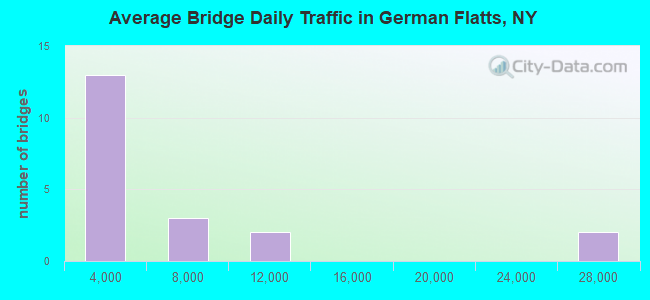
- 104,463Total average daily traffic
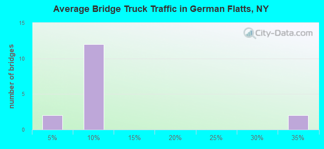
- 7,398Total average daily truck traffic
- National Bridge Inventory (NBI) Registered Bridges for German Flatts
- No street view available for this location
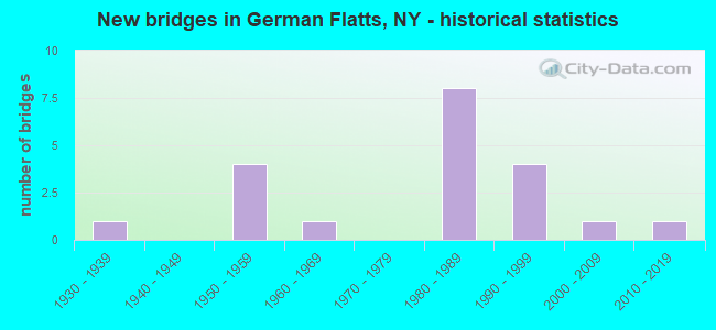
- New bridges - historical statistics
- 11930-1939
- 41950-1959
- 11960-1969
- 81980-1989
- 41990-1999
- 12000-2009
- 12010-2019
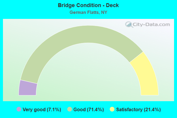
- Bridge Condition - Deck
- 7.1%Very good
- 71.4%Good
- 21.4%Satisfactory
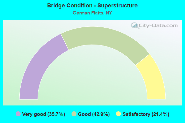
- Bridge Condition - Superstructure
- 35.7%Very good
- 42.9%Good
- 21.4%Satisfactory
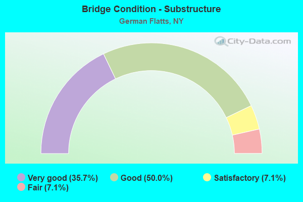
- Bridge Condition - Substructure
- 35.7%Very good
- 50.0%Good
- 7.1%Satisfactory
- 7.1%Fair
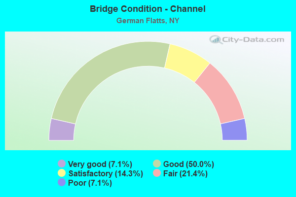
- Bridge Condition - Channel
- 7.1%Very good
- 50.0%Good
- 14.3%Satisfactory
- 21.4%Fair
- 7.1%Poor
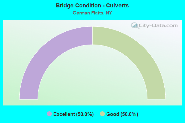
- Bridge Condition - Culverts
- 50.0%Excellent
- 50.0%Good
Find on map >> Show street view
Structure Number: 100276, Location: 3.6 MI W JCT RTS 167 & 5S (Lat: 43.014419, Lng: -74.947550), Route carried "on" structure: State highway 5S, Year Built: 1995, Status: Open, Structure Length: 12.74m (41.80ft), Average Daily Traffic: 5,239 (year 2019), Truck Traffic: 8%, Average Future Daily Traffic: 5,465 (year 2040), Design Load: HS 25 or greater, Features Intersected: 90IX EB, RTE I90
Minimum Vertical Clearance: 30+ m (98+ ft), Kilometerpoint: 22.767, Lanes on structure: 2, Lanes under structure: 4, Base Highway Network: Yes, Owner: State Highway Agency, Maintenance Responsibility: State Toll Authority, Approaching Roadway Width: 11.3m (37.1ft), Skew: 4 degrees, Material/Design: Steel continuous, Design/Construction: Stringer/Multi-beam, Number Of Spans In Main Unit: 3, Length of Maximum Span: 43.9m (144.0ft), Curb-To-Curb Width: 11.0m (36.1ft), Out-to-Out Width: 11.9m (39.0ft)
Condition: Deck: Good, Superstructure: Good, Substructure: Good, Operating Rating: 86.2 metric tons, Method Used To Determine Operating Rating: Load Factor (LF), Inventory Rating: 49.0 metric tons, Method Used To Determine Inventory Rating: Load Factor (LF), Structural Evaluation: Better than present minimum criteria, Deck Geometry: Meets minimum limits, Underclear: Meets minimum limits, Approach Roadway Alignment: Equal to present desirable criteria, Length Of Structure Improvement: 12.74m (41.80ft), Designated Inspection Frequency: Every 24 months, Inspection Date: May 2020, Bridge Improvement Cost: $2,394,000, Roadway Improvement Cost: $1,402,000, Total Project Cost: $3,795,000 ( Estimate for 2021), Deck Structure Type: Concrete Cast-file-Place, Wearing Surface/Protective System: Wearing Surface: Integral Concrete, Deck Protection: Galvanized Reinforcing
Find on map >> Show street view
Structure Number: 100277, Location: 2.5 M W JCT RTS 176 & 5S (Lat: 43.013369, Lng: -74.925408), Route carried "on" structure: State highway 5S, Year Built: 1995, Status: Open, Structure Length: 8.32m (27.30ft), Average Daily Traffic: 3,718 (year 2020), Truck Traffic: 8%, Average Future Daily Traffic: 3,878 (year 2040), Design Load: HS 25 or greater, Features Intersected: 90IX EB, RTE I90
Minimum Vertical Clearance: 30+ m (98+ ft), Kilometerpoint: 24.746, Lanes on structure: 2, Lanes under structure: 4, Base Highway Network: Yes, Owner: State Toll Authority, Approaching Roadway Width: 11.3m (37.1ft), Skew: 4 degrees, Material/Design: Steel continuous, Design/Construction: Stringer/Multi-beam, Number Of Spans In Main Unit: 2, Length of Maximum Span: 41.5m (136.2ft), Curb-To-Curb Width: 11.0m (36.1ft), Out-to-Out Width: 11.9m (39.0ft)
Condition: Deck: Good, Superstructure: Good, Substructure: Good, Operating Rating: 86.2 metric tons, Method Used To Determine Operating Rating: Load Factor (LF), Inventory Rating: 49.9 metric tons, Method Used To Determine Inventory Rating: Load Factor (LF), Structural Evaluation: Better than present minimum criteria, Deck Geometry: Somewhat better than minimum adequacy, Underclear: High priority of corrective action, Approach Roadway Alignment: Equal to present desirable criteria, Length Of Structure Improvement: 8.32m (27.30ft), Designated Inspection Frequency: Every 24 months, Inspection Date: May 2020, Bridge Improvement Cost: $1,689,000, Roadway Improvement Cost: $989,000, Total Project Cost: $2,678,000 ( Estimate for 2021), Deck Structure Type: Concrete Cast-file-Place, Wearing Surface/Protective System: Wearing Surface: Integral Concrete, Deck Protection: Galvanized Reinforcing
Find on map >> Show street view
Structure Number: 103896, Location: 1.4M SE JCT RTS 28 & 168 (Lat: 42.985189, Lng: -74.990286), Route carried "on" structure: State highway 168, Year Built: 1987, Status: Open, Structure Length: 1.89m (6.20ft), Average Daily Traffic: 1,080 (year 2020), Truck Traffic: 5%, Average Future Daily Traffic: 1,102 (year 2040), Design Load: HS 20, Features Intersected: FULMER CREEK
Minimum Vertical Clearance: 30+ m (98+ ft), Kilometerpoint: 2.623, Lanes on structure: 2, Base Highway Network: Yes, Owner: State Highway Agency, Approaching Roadway Width: 9.1m (29.9ft), Skew: 1 degrees, Material/Design: Prestressed concrete, Design/Construction: Box Beam or Girders - Multiple, Number Of Spans In Main Unit: 1, Length of Maximum Span: 17.6m (57.7ft), Curb-To-Curb Width: 9.1m (29.9ft), Out-to-Out Width: 10.1m (33.1ft)
Condition: Deck: Good, Superstructure: Very good, Substructure: Very good, Channel: Good, Operating Rating: 64.4 metric tons, Method Used To Determine Operating Rating: Load Factor (LF), Inventory Rating: 21.8 metric tons, Method Used To Determine Inventory Rating: Load Factor (LF), Structural Evaluation: Somewhat better than minimum adequacy, Deck Geometry: Somewhat better than minimum adequacy, Waterway Adequacy: Somewhat better than minimum adequacy, Approach Roadway Alignment: Equal to present desirable criteria, Length Of Structure Improvement: 1.88m (6.17ft), Designated Inspection Frequency: Every 24 months, Inspection Date: May 2021, Bridge Improvement Cost: $434,000, Roadway Improvement Cost: $254,000, Total Project Cost: $689,000 ( Estimate for 2021), Wearing Surface/Protective System: Wearing Surface: Bituminous, Membrane: Other
Find on map >> Show street view
Structure Number: 103897, Location: 1.8 MI SE JCT SH28 &SH168 (Lat: 42.982000, Lng: -74.985856), Route carried "on" structure: State highway 168, Year Built: 1987, Status: Open, Structure Length: 2.01m (6.59ft), Average Daily Traffic: 1,080 (year 2020), Truck Traffic: 5%, Average Future Daily Traffic: 1,102 (year 2040), Design Load: HS 20, Features Intersected: FULMER CREEK
Minimum Vertical Clearance: 30+ m (98+ ft), Kilometerpoint: 2.977, Lanes on structure: 2, Base Highway Network: Yes, Owner: State Highway Agency, Approaching Roadway Width: 6.7m (22.0ft), Skew: 1 degrees, Material/Design: Prestressed concrete, Design/Construction: Box Beam or Girders - Multiple, Number Of Spans In Main Unit: 1, Length of Maximum Span: 18.8m (61.7ft), Curb-To-Curb Width: 9.1m (29.9ft), Out-to-Out Width: 10.1m (33.1ft)
Condition: Deck: Good, Superstructure: Good, Substructure: Satisfactory, Channel: Good, Operating Rating: 84.4 metric tons, Method Used To Determine Operating Rating: Load Factor (LF), Inventory Rating: 47.2 metric tons, Method Used To Determine Inventory Rating: Load Factor (LF), Structural Evaluation: Equal to present minimum criteria, Deck Geometry: Somewhat better than minimum adequacy, Waterway Adequacy: Somewhat better than minimum adequacy, Approach Roadway Alignment: Equal to present desirable criteria, Length Of Structure Improvement: 2.01m (6.59ft), Designated Inspection Frequency: Every 24 months, Inspection Date: April 2021, Bridge Improvement Cost: $452,000, Roadway Improvement Cost: $265,000, Total Project Cost: $717,000 ( Estimate for 2021), Wearing Surface/Protective System: Wearing Surface: Bituminous
Find on map >> Show street view
Structure Number: 103898, Location: 1.9 MI SE JCT SH28 &SH168 (Lat: 42.980622, Lng: -74.984192), Route carried "on" structure: State highway 168, Year Built: 1987, Status: Open, Structure Length: 2.19m (7.19ft), Average Daily Traffic: 1,080 (year 2020), Truck Traffic: 5%, Average Future Daily Traffic: 1,102 (year 2040), Design Load: HS 20, Features Intersected: FULMER CREEK
Minimum Vertical Clearance: 30+ m (98+ ft), Kilometerpoint: 3.186, Lanes on structure: 2, Base Highway Network: Yes, Owner: State Highway Agency, Approaching Roadway Width: 9.1m (29.9ft), Skew: 2 degrees, Material/Design: Prestressed concrete, Design/Construction: Box Beam or Girders - Multiple, Number Of Spans In Main Unit: 1, Length of Maximum Span: 21.3m (69.9ft), Curb-To-Curb Width: 9.1m (29.9ft), Out-to-Out Width: 10.0m (32.8ft)
Condition: Deck: Good, Superstructure: Good, Substructure: Good, Channel: Good, Operating Rating: 72.6 metric tons, Method Used To Determine Operating Rating: Load Factor (LF), Inventory Rating: 39.9 metric tons, Method Used To Determine Inventory Rating: Load Factor (LF), Structural Evaluation: Better than present minimum criteria, Deck Geometry: Somewhat better than minimum adequacy, Waterway Adequacy: Somewhat better than minimum adequacy, Approach Roadway Alignment: Equal to present desirable criteria, Length Of Structure Improvement: 2.19m (7.19ft), Designated Inspection Frequency: Every 24 months, Inspection Date: April 2021, Bridge Improvement Cost: $479,000, Roadway Improvement Cost: $281,000, Total Project Cost: $760,000 ( Estimate for 2021), Wearing Surface/Protective System: Wearing Surface: Bituminous, Membrane: Other
Find on map >> Show street view
Structure Number: 103899, Location: 2.9M SE JCT RTS 28&168 (Lat: 42.972314, Lng: -74.968431), Route carried "on" structure: State highway 168, Year Built: 1987, Status: Open, Structure Length: 3.47m (11.38ft), Average Daily Traffic: 1,080 (year 2020), Truck Traffic: 5%, Average Future Daily Traffic: 1,102 (year 2040), Design Load: HS 20, Features Intersected: FULMER CREEK
Minimum Vertical Clearance: 30+ m (98+ ft), Kilometerpoint: 4.827, Lanes on structure: 2, Base Highway Network: Yes, Owner: State Highway Agency, Approaching Roadway Width: 9.1m (29.9ft), Skew: 3 degrees, Material/Design: Steel, Design/Construction: Stringer/Multi-beam, Number Of Spans In Main Unit: 1, Length of Maximum Span: 33.2m (108.9ft), Curb-To-Curb Width: 9.1m (29.9ft), Out-to-Out Width: 9.8m (32.2ft)
Condition: Deck: Satisfactory, Superstructure: Very good, Substructure: Good, Channel: Fair, Operating Rating: 68.0 metric tons, Method Used To Determine Operating Rating: Load Factor (LF), Inventory Rating: 40.8 metric tons, Method Used To Determine Inventory Rating: Load Factor (LF), Structural Evaluation: Better than present minimum criteria, Deck Geometry: Somewhat better than minimum adequacy, Waterway Adequacy: Somewhat better than minimum adequacy, Approach Roadway Alignment: Equal to present desirable criteria, Length Of Structure Improvement: 3.47m (11.38ft), Designated Inspection Frequency: Every 24 months, Inspection Date: July 2021, Bridge Improvement Cost: $814,000, Roadway Improvement Cost: $477,000, Total Project Cost: $1,290,000 ( Estimate for 2021), Deck Structure Type: Concrete Cast-file-Place, Wearing Surface/Protective System: Wearing Surface: Monolithic Concrete, Deck Protection: Epoxy Coated Reinforcing
Find on map >> Show street view
Structure Number: 1039, Location: 3.2MI SE JCT RTS 28 & 168 (Lat: 42.970111, Lng: -74.961497), Route carried "on" structure: State highway 168, Year Built: 1987, Status: Open, Structure Length: 1.86m (6.10ft), Average Daily Traffic: 1,080 (year 2020), Truck Traffic: 5%, Average Future Daily Traffic: 1,512 (year 2040), Design Load: HS 20, Features Intersected: FULMER CREEK
Minimum Vertical Clearance: 30+ m (98+ ft), Kilometerpoint: 5.455, Lanes on structure: 2, Base Highway Network: Yes, Owner: State Highway Agency, Approaching Roadway Width: 9.1m (29.9ft), Material/Design: Prestressed concrete, Design/Construction: Box Beam or Girders - Multiple, Number Of Spans In Main Unit: 1, Length of Maximum Span: 17.3m (56.8ft), Curb-To-Curb Width: 9.1m (29.9ft), Out-to-Out Width: 10.1m (33.1ft)
Condition: Deck: Good, Superstructure: Very good, Substructure: Very good, Channel: Good, Operating Rating: 77.1 metric tons, Method Used To Determine Operating Rating: Load Factor (LF), Inventory Rating: 30.8 metric tons, Method Used To Determine Inventory Rating: Load Factor (LF), Structural Evaluation: Better than present minimum criteria, Deck Geometry: Somewhat better than minimum adequacy, Waterway Adequacy: Somewhat better than minimum adequacy, Approach Roadway Alignment: Equal to present desirable criteria, Length Of Structure Improvement: 1.85m (6.07ft), Designated Inspection Frequency: Every 24 months, Inspection Date: May 2021, Bridge Improvement Cost: $433,000, Roadway Improvement Cost: $253,000, Total Project Cost: $686,000 ( Estimate for 2021), Wearing Surface/Protective System: Wearing Surface: Bituminous, Membrane: Other
Find on map >> Show street view
Structure Number: 103901, Location: 3.4 MI SE JCT RTS 28&168 (Lat: 42.969458, Lng: -74.959317), Route carried "on" structure: State highway 168, Year Built: 1987, Status: Open, Structure Length: 1.89m (6.20ft), Average Daily Traffic: 452 (year 2018), Truck Traffic: 8%, Average Future Daily Traffic: 633 (year 2038), Design Load: HS 20, Features Intersected: FULMER CREEK
Minimum Vertical Clearance: 30+ m (98+ ft), Kilometerpoint: 5.648, Lanes on structure: 2, Base Highway Network: Yes, Owner: State Highway Agency, Approaching Roadway Width: 8.8m (28.9ft), Skew: 2 degrees, Material/Design: Prestressed concrete, Design/Construction: Box Beam or Girders - Multiple, Number Of Spans In Main Unit: 1, Length of Maximum Span: 17.3m (56.8ft), Curb-To-Curb Width: 9.1m (29.9ft), Out-to-Out Width: 10.1m (33.1ft)
Condition: Deck: Good, Superstructure: Very good, Substructure: Very good, Channel: Fair, Operating Rating: 78.9 metric tons, Method Used To Determine Operating Rating: Load Factor (LF), Inventory Rating: 41.7 metric tons, Method Used To Determine Inventory Rating: Load Factor (LF), Structural Evaluation: Equal to present desirable criteria, Deck Geometry: Equal to present minimum criteria, Waterway Adequacy: Meets minimum limits, Approach Roadway Alignment: Equal to present desirable criteria, Length Of Structure Improvement: 1.88m (6.17ft), Designated Inspection Frequency: Every 24 months, Inspection Date: April 2021, Bridge Improvement Cost: $543,000, Roadway Improvement Cost: $318,000, Total Project Cost: $861,000 ( Estimate for 2021), Wearing Surface/Protective System: Wearing Surface: Bituminous
Find on map >> Show street view
Structure Number: 105134, Location: 4.7M SE JCT RTS 28&168 (Lat: 42.967439, Lng: -74.929758), Route carried "on" structure: State highway 168, Year Built: 1987, Status: Open, Structure Length: 2.01m (6.59ft), Average Daily Traffic: 452 (year 2018), Truck Traffic: 8%, Average Future Daily Traffic: 633 (year 2038), Design Load: HS 20, Features Intersected: FULMER CREEK
Minimum Vertical Clearance: 30+ m (98+ ft), Kilometerpoint: 8.158, Lanes on structure: 2, Base Highway Network: Yes, Owner: State Highway Agency, Approaching Roadway Width: 6.7m (22.0ft), Skew: 4 degrees, Material/Design: Prestressed concrete, Design/Construction: Box Beam or Girders - Multiple, Number Of Spans In Main Unit: 1, Length of Maximum Span: 18.2m (59.7ft), Curb-To-Curb Width: 9.1m (29.9ft), Out-to-Out Width: 10.1m (33.1ft)
Condition: Deck: Good, Superstructure: Good, Substructure: Very good, Channel: Satisfactory, Operating Rating: 65.3 metric tons, Method Used To Determine Operating Rating: Load Factor (LF), Inventory Rating: 22.7 metric tons, Method Used To Determine Inventory Rating: Load Factor (LF), Structural Evaluation: Equal to present minimum criteria, Deck Geometry: Equal to present minimum criteria, Waterway Adequacy: Meets minimum limits, Approach Roadway Alignment: Equal to present desirable criteria, Length Of Structure Improvement: 2.01m (6.59ft), Designated Inspection Frequency: Every 24 months, Inspection Date: June 2021, Bridge Improvement Cost: $554,000, Roadway Improvement Cost: $325,000, Total Project Cost: $879,000 ( Estimate for 2021), Wearing Surface/Protective System: Wearing Surface: Bituminous, Membrane: Other
Find on map >> Show street view
Structure Number: 107359, Location: 2.7MI SE JCT RTS 28 & 168 (Lat: 42.973767, Lng: -74.971172), Route carried "on" structure: State highway 168, Year Built: 1987, Status: Open, Structure Length: 0.82m (2.69ft), Average Daily Traffic: 1,080 (year 2020), Truck Traffic: 5%, Average Future Daily Traffic: 1,102 (year 2040), Design Load: HS 20, Features Intersected: FLATT CREEK
Minimum Vertical Clearance: 30+ m (98+ ft), Kilometerpoint: 4.537, Lanes on structure: 2, Base Highway Network: Yes, Owner: State Highway Agency, Approaching Roadway Width: 6.7m (22.0ft), Skew: 4 degrees, Material/Design: Concrete, Design/Construction: Culvert, Number Of Spans In Main Unit: 1, Length of Maximum Span: 7.9m (25.9ft), Curb-To-Curb Width: 9.1m (29.9ft), Out-to-Out Width: 10.1m (33.1ft)
Condition: Channel: Satisfactory, Culverts: Good, Operating Rating: 78.2 metric tons, Method Used To Determine Operating Rating: Field evaluation and documented engineering judgment, Inventory Rating: 32.7 metric tons, Method Used To Determine Inventory Rating: Field evaluation and documented engineering judgment, Structural Evaluation: Better than present minimum criteria, Deck Geometry: Somewhat better than minimum adequacy, Waterway Adequacy: Somewhat better than minimum adequacy, Approach Roadway Alignment: Equal to present desirable criteria, Length Of Structure Improvement: 0.82m (2.69ft), Designated Inspection Frequency: Every 24 months, Inspection Date: April 2021, Bridge Improvement Cost: $255,000, Roadway Improvement Cost: $149,000, Total Project Cost: $404,000 ( Estimate for 2021)
Find on map >> Show street view
Structure Number: 330768, Location: 1 MILE SOUTH OF ILION (Lat: 42.998011, Lng: -75.050839), Route carried "on" structure: County highway , Year Built: 2003, Status: Open, Structure Length: 1.28m (4.20ft), Average Daily Traffic: 1,700 (year 2018), Truck Traffic: 7%, Average Future Daily Traffic: 2,103 (year 2040), Design Load: HS 25 or greater, Features Intersected: STEELE CREEK, Facility Carried by Structure: CR15 SPINNERVILLE
Minimum Vertical Clearance: 30+ m (98+ ft), Kilometerpoint: 0.016, Lanes on structure: 2, Owner: County Highway Agency, Approaching Roadway Width: 6.4m (21.0ft), Material/Design: Concrete, Design/Construction: Frame, Number Of Spans In Main Unit: 1, Length of Maximum Span: 12.2m (40.0ft), Curb-To-Curb Width: 10.9m (35.8ft), Out-to-Out Width: 12.1m (39.7ft)
Condition: Deck: Very good, Superstructure: Very good, Substructure: Very good, Channel: Fair, Operating Rating: 81.6 metric tons, Method Used To Determine Operating Rating: Load Factor (LF), Inventory Rating: 49.0 metric tons, Method Used To Determine Inventory Rating: Load Factor (LF), Structural Evaluation: Equal to present desirable criteria, Deck Geometry: Equal to present minimum criteria, Waterway Adequacy: Meets minimum limits, Approach Roadway Alignment: Equal to present minimum criteria, Length Of Structure Improvement: 1.28m (4.20ft), Designated Inspection Frequency: Every 24 months, Inspection Date: April 2021, Bridge Improvement Cost: $501,000, Roadway Improvement Cost: $294,000, Total Project Cost: $795,000 ( Estimate for 2021)
Find on map >> Show street view
Structure Number: 330769, Location: 1.5 MI E OF PAINES HOLLOW (Lat: 42.967350, Lng: -74.929117), Route carried "on" structure: County highway , Year Built: 1935, Year Reconstructed: 1996, Status: Open, Structure Length: 0.91m (2.99ft), Average Daily Traffic: 104 (year 2019), Truck Traffic: 4%, Average Future Daily Traffic: 146 (year 2039), Design Load: HS 25 or greater, Features Intersected: FULMER CREEK, Facility Carried by Structure: COUNTY ROAD 68
Minimum Vertical Clearance: 30+ m (98+ ft), Kilometerpoint: 11.472, Lanes on structure: 2, Owner: County Highway Agency, Approaching Roadway Width: 5.5m (18.0ft), Skew: 1 degrees, Material/Design: Prestressed concrete, Design/Construction: Box Beam or Girders - Multiple, Number Of Spans In Main Unit: 1, Length of Maximum Span: 8.5m (27.9ft), Curb-To-Curb Width: 7.2m (23.6ft), Out-to-Out Width: 7.4m (24.3ft)
Condition: Deck: Satisfactory, Superstructure: Satisfactory, Substructure: Fair, Channel: Poor, Operating Rating: 70.8 metric tons, Method Used To Determine Operating Rating: Load Factor (LF), Inventory Rating: 41.7 metric tons, Method Used To Determine Inventory Rating: Load Factor (LF), Structural Evaluation: Somewhat better than minimum adequacy, Deck Geometry: Meets minimum limits, Waterway Adequacy: Meets minimum limits, Approach Roadway Alignment: Somewhat better than minimum adequacy, Length Of Structure Improvement: 0.91m (2.99ft), Designated Inspection Frequency: Every 24 months, Inspection Date: July 2020, Bridge Improvement Cost: $237,000, Roadway Improvement Cost: $139,000, Total Project Cost: $376,000 ( Estimate for 2021), Wearing Surface/Protective System: Wearing Surface: Bituminous
Find on map >> Show street view
Structure Number: 337158, Location: AT TOWN OF GERMAN FLATTS (Lat: 42.992669, Lng: -75.050244), Route carried "on" structure: County highway , Year Built: 2018, Status: Open, Structure Length: 0.85m (2.79ft), Average Daily Traffic: 1,700 (year 2018), Truck Traffic: 7%, Average Future Daily Traffic: 2,103 (year 2040), Design Load: HL 93, Features Intersected: STEELE CREEK TRIBUTARY, Facility Carried by Structure: CR15 SPINNERVILLE-
Minimum Vertical Clearance: 32.69m (107.25ft), Kilometerpoint: 0.692, Lanes on structure: 2, Owner: County Highway Agency, Approaching Roadway Width: 7.9m (25.9ft), Skew: 2 degrees, Material/Design: Concrete, Design/Construction: Culvert, Number Of Spans In Main Unit: 1, Length of Maximum Span: 7.6m (24.9ft)
Condition: Channel: Very good, Culverts: Excellent, Operating Rating: 97.2 metric tons, Method Used To Determine Operating Rating: Load and Resistance Factor Rating (LRFR) rating reported by rating factor(RF) method using HL-93 loadings, Inventory Rating: 84.2 metric tons, Method Used To Determine Inventory Rating: Load and Resistance Factor Rating (LRFR) rating reported by rating factor(RF) method using HL-93 loadings, Structural Evaluation: Superior to present desirable criteria, Waterway Adequacy: Equal to present minimum criteria, Approach Roadway Alignment: Better than present minimum criteria, Length Of Structure Improvement: 0.85m (2.79ft), Designated Inspection Frequency: Every 24 months, Inspection Date: August 2021, Bridge Improvement Cost: $171,000, Roadway Improvement Cost: $100,000, Total Project Cost: $271,000 ( Estimate for 2021), Wearing Surface/Protective System: Wearing Surface: Bituminous
Find on map >> Show street view
Structure Number: 430823, Location: .2 MI E OF EXIT 30 - I90 (Lat: 43.018067, Lng: -74.979456), Route carried "on" structure: State highway 922B, Year Built: 1967, Status: Open, Structure Length: 19.08m (62.60ft), Average Daily Traffic: 4,557 (year 2020), Truck Traffic: 4%, Average Future Daily Traffic: 5,535 (year 2040), Design Load: HS 20, Features Intersected: Canal Trail, Mohawk Rive
Minimum Vertical Clearance: 30+ m (98+ ft), Kilometerpoint: 0.000, Lanes on structure: 2, Base Highway Network: Yes, Owner: State Highway Agency, Approaching Roadway Width: 9.1m (29.9ft), Navigation Control: Yes ( Vertical Clearance: 6.1m (20.0ft), Horizontal Clearance: 31.1m (102.0ft)), Material/Design: Steel continuous, Design/Construction: Stringer/Multi-beam, Number Of Spans In Main Unit: 4, Length of Maximum Span: 54.9m (180.1ft), Curb or Sidewalk Widths: Left: 0.4m (1.3ft), Right: 0.4m (1.3ft), Curb-To-Curb Width: 9.1m (29.9ft), Out-to-Out Width: 10.6m (34.8ft)
Condition: Deck: Satisfactory, Superstructure: Good, Substructure: Good, Channel: Good, Operating Rating: 60.8 metric tons, Method Used To Determine Operating Rating: Load Factor (LF), Inventory Rating: 36.3 metric tons, Method Used To Determine Inventory Rating: Load Factor (LF), Structural Evaluation: Better than present minimum criteria, Deck Geometry: Meets minimum limits, Waterway Adequacy: Somewhat better than minimum adequacy, Approach Roadway Alignment: Equal to present desirable criteria, Length Of Structure Improvement: 19.08m (62.60ft), Designated Inspection Frequency: Every 24 months, Underwater Inspection Frequency: Every 60 months, Inspection Date: June 2021, Underwater Inspection Date: August 2018, Bridge Improvement Cost: $3,024,000, Roadway Improvement Cost: $1,771,000, Total Project Cost: $4,795,000 ( Estimate for 2021), Deck Structure Type: Concrete Cast-file-Place, Wearing Surface/Protective System: Wearing Surface: Integral Concrete
Find on map >> Show street view
Structure Number: 4423081, Location: 0.7MI EAST INT 28 RTE 90I (Lat: 43.016419, Lng: -74.979994), Route carried "on" structure: Interstate 90, Year Built: 1954, Year Reconstructed: 1995, Status: Open, Structure Length: 30.48m (100.00ft), Average Daily Traffic: 9,160 (year 2020), Truck Traffic: 32%, Average Future Daily Traffic: 10,554 (year 2040), Design Load: HS 25 or greater, Features Intersected: Erie Canalway Trail, RTE
Minimum Vertical Clearance: 30+ m (98+ ft), Kilometerpoint: 18.761, Lanes on structure: 2, Lanes under structure: 2, Base Highway Network: Yes, Toll: On Interstate toll segment, Owner: State Toll Authority, Approaching Roadway Width: 16.2m (53.1ft), Skew: 4 degrees, Navigation Control: Yes ( Vertical Clearance: 6.1m (20.0ft), Horizontal Clearance: 65.8m (215.9ft)), Material/Design: Steel continuous, Design/Construction: Stringer/Multi-beam, Number Of Spans In Main Unit: 9, Length of Maximum Span: 65.2m (213.9ft), Curb-To-Curb Width: 16.2m (53.1ft), Out-to-Out Width: 17.1m (56.1ft)
Condition: Deck: Good, Superstructure: Satisfactory, Substructure: Good, Channel: Good, Operating Rating: 69.9 metric tons, Method Used To Determine Operating Rating: Load Factor (LF), Inventory Rating: 40.8 metric tons, Method Used To Determine Inventory Rating: Load Factor (LF), Structural Evaluation: Equal to present minimum criteria, Deck Geometry: Superior to present desirable criteria, Underclear: High priority of corrective action, Waterway Adequacy: Superior to present desirable criteria, Approach Roadway Alignment: Equal to present desirable criteria, Length Of Structure Improvement: 30.48m (100.00ft), Designated Inspection Frequency: Every 24 months, Inspection Date: May 2021, Bridge Improvement Cost: $7,995,000, Roadway Improvement Cost: $4,682,000, Total Project Cost: $12,677,000 ( Estimate for 2021), Deck Structure Type: Concrete Cast-file-Place, Wearing Surface/Protective System: Wearing Surface: Bituminous, Membrane: Other, Deck Protection: Epoxy Coated Reinforcing
Find on map >> Show street view
Structure Number: 4423082, Location: 0.7MI EAST INT 28 RTE 90I (Lat: 43.017331, Lng: -74.983014), Route carried "on" structure: Interstate 90, Year Built: 1954, Year Reconstructed: 1995, Status: Open, Structure Length: 31.12m (102.10ft), Average Daily Traffic: 9,160 (year 2020), Truck Traffic: 32%, Average Future Daily Traffic: 10,554 (year 2040), Design Load: HS 25 or greater, Features Intersected: Erie Canalway Trail, RTE
Minimum Vertical Clearance: 30+ m (98+ ft), Kilometerpoint: 18.680, Lanes on structure: 2, Lanes under structure: 2, Base Highway Network: Yes, Toll: On Interstate toll segment, Owner: State Toll Authority, Approaching Roadway Width: 16.2m (53.1ft), Skew: 4 degrees, Navigation Control: Yes ( Vertical Clearance: 6.1m (20.0ft), Horizontal Clearance: 64.6m (211.9ft)), Material/Design: Steel continuous, Design/Construction: Stringer/Multi-beam, Number Of Spans In Main Unit: 9, Length of Maximum Span: 65.8m (215.9ft), Curb-To-Curb Width: 16.2m (53.1ft), Out-to-Out Width: 17.1m (56.1ft)
Condition: Deck: Good, Superstructure: Satisfactory, Substructure: Good, Channel: Good, Operating Rating: 69.9 metric tons, Method Used To Determine Operating Rating: Load Factor (LF), Inventory Rating: 40.8 metric tons, Method Used To Determine Inventory Rating: Load Factor (LF), Structural Evaluation: Equal to present minimum criteria, Deck Geometry: Superior to present desirable criteria, Underclear: Meets minimum limits, Waterway Adequacy: Superior to present desirable criteria, Approach Roadway Alignment: Equal to present desirable criteria, Length Of Structure Improvement: 31.12m (102.10ft), Designated Inspection Frequency: Every 24 months, Inspection Date: May 2021, Bridge Improvement Cost: $8,153,000, Roadway Improvement Cost: $4,774,000, Total Project Cost: $12,928,000 ( Estimate for 2021), Deck Structure Type: Concrete Cast-file-Place, Wearing Surface/Protective System: Wearing Surface: Bituminous, Membrane: Other, Deck Protection: Epoxy Coated Reinforcing
Find on map >> Show street view
Structure Number: 100276, Location: 3.6 MI W JCT RTS 167 & 5S (Lat: 43.014419, Lng: -74.947550), Route carried "under" structure: Interstate 90, Year Built: 1995, Structure Length: 0. m, Average Daily Traffic: 26,000 (year 2004), Features Intersected: 90IX EB, RTE I90, Facility Carried by Structure: RTE 5S
Minimum Vertical Clearance: 5.13m (16.83ft), Kilometerpoint: 349.974, Lanes on structure: 2, Lanes under structure: 2, Toll: On Interstate toll segment, Material/Design: Steel continuous, Design/Construction: Stringer/Multi-beam, Length of Maximum Span: 43.9m (144.0ft)
Find on map >> Show street view
Structure Number: 100277, Location: 2.5 M W JCT RTS 176 & 5S (Lat: 43.013369, Lng: -74.925408), Route carried "under" structure: Interstate 90, Year Built: 1995, Structure Length: 0. m, Average Daily Traffic: 26,000 (year 2004), Features Intersected: 90IX EB, RTE I90, Facility Carried by Structure: RTE 5S
Minimum Vertical Clearance: 5.18m (16.99ft), Kilometerpoint: 348.107, Lanes on structure: 2, Lanes under structure: 2, Toll: On Interstate toll segment, Material/Design: Steel continuous, Design/Construction: Stringer/Multi-beam, Length of Maximum Span: 41.5m (136.2ft)
Find on map >> Show street view
Structure Number: 4423081, Location: 0.7MI EAST INT 28 RTE 90I (Lat: 43.016419, Lng: -74.979994), Route carried "under" structure: State highway 5S, Year Built: 1954, Structure Length: 0. m, Average Daily Traffic: 1,873 (year 1999), Features Intersected: Erie Canalway Trail, RTE, Facility Carried by Structure: RTE I90
Minimum Vertical Clearance: 6.63m (21.75ft), Kilometerpoint: 20.466, Lanes on structure: 2, Lanes under structure: 2, Material/Design: Steel continuous, Design/Construction: Stringer/Multi-beam, Length of Maximum Span: 65.2m (213.9ft)
Find on map >> Show street view
Structure Number: 4423082, Location: 0.7MI EAST INT 28 RTE 90I (Lat: 43.017331, Lng: -74.983014), Route carried "under" structure: State highway 5S, Year Built: 1954, Structure Length: 0. m, Average Daily Traffic: 7,868 (year 2015), Features Intersected: Erie Canalway Trail, RTE, Facility Carried by Structure: RTE I90
Minimum Vertical Clearance: 4.37m (14.34ft), Kilometerpoint: 20.466, Lanes on structure: 2, Lanes under structure: 2, Material/Design: Steel continuous, Design/Construction: Stringer/Multi-beam, Length of Maximum Span: 65.8m (215.9ft)