Bridge Statistics for Gig Harbor, Washington (WA)
Condition, Traffic, Stress, Structural Evaluation, Project Costs
- National Bridge Inventory (NBI) Statistics
- 16Number of bridges
- 187ft / 56.5mTotal length
- $38,178,000Total costs
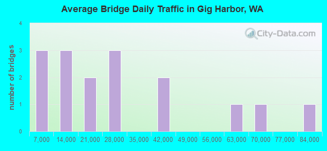
- 423,254Total average daily traffic
- 19,216Total average daily truck traffic
- National Bridge Inventory (NBI) Registered Bridges for Gig Harbor
- No street view available for this location
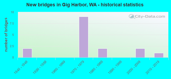
- New bridges - historical statistics
- 21940-1949
- 91970-1979
- 21980-1989
- 22000-2009
- 12010-2019
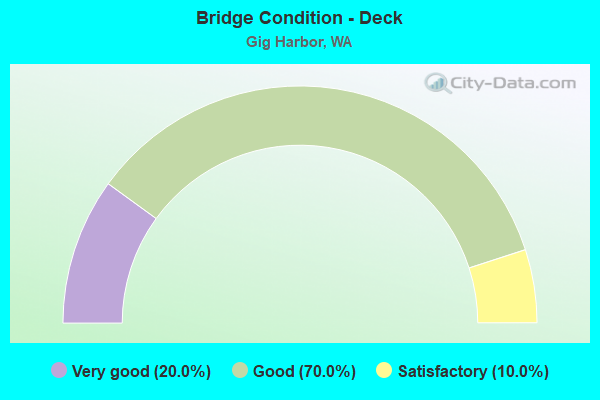
- Bridge Condition - Deck
- 20.0%Very good
- 70.0%Good
- 10.0%Satisfactory
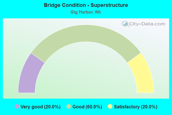
- Bridge Condition - Superstructure
- 20.0%Very good
- 60.0%Good
- 20.0%Satisfactory
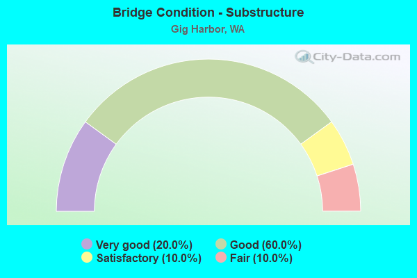
- Bridge Condition - Substructure
- 20.0%Very good
- 60.0%Good
- 10.0%Satisfactory
- 10.0%Fair
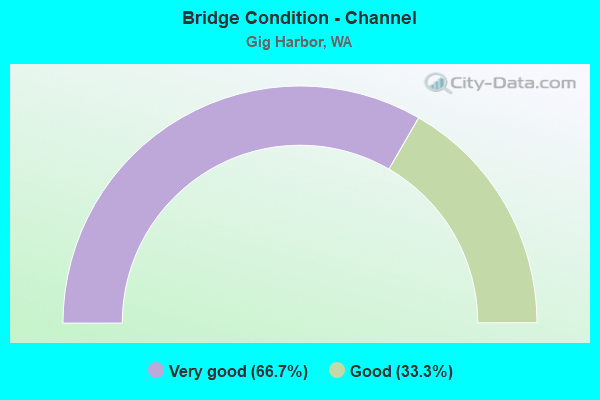
- Bridge Condition - Channel
- 66.7%Very good
- 33.3%Good
Find on map >> Show street view
Structure Number: 3639A, Location: 12.8 N JCT I-5 (Lat: 47.330250, Lng: -122.598778), Route carried "on" structure: State highway 16, Year Built: 1949, Status: Open, Structure Length: 4.97m (16.31ft), Average Daily Traffic: 39,307 (year 2019), Truck Traffic: 5%, Average Future Daily Traffic: 56,916 (year 2039), Design Load: HS 20, Features Intersected: ROSEDALE RD
Minimum Vertical Clearance: 30+ m (98+ ft), Kilometerpoint: 20.535, Lanes on structure: 2, Lanes under structure: 2, Base Highway Network: Yes, Owner: State Highway Agency, Approaching Roadway Width: 11.6m (38.1ft), Material/Design: Concrete continuous, Design/Construction: Tee Beam, Number Of Spans In Main Unit: 3, Length of Maximum Span: 21.3m (69.9ft), Curb or Sidewalk Widths: Left: 0.6m (2.0ft), Right: 0.6m (2.0ft), Curb-To-Curb Width: 8.5m (27.9ft), Out-to-Out Width: 11.0m (36.1ft)
Condition: Deck: Satisfactory, Superstructure: Satisfactory, Substructure: Good, Operating Rating: 31.4 metric tons, Method Used To Determine Operating Rating: Load and Resistance Factor Rating (LRFR) rating reported by rating factor(RF) method using HL-93 loadings, Inventory Rating: 24.3 metric tons, Method Used To Determine Inventory Rating: Load and Resistance Factor Rating (LRFR) rating reported by rating factor(RF) method using HL-93 loadings, Structural Evaluation: Equal to present minimum criteria, Deck Geometry: High priority of replacement, Underclear: Somewhat better than minimum adequacy, Approach Roadway Alignment: Equal to present desirable criteria, Length Of Structure Improvement: 4.97m (16.31ft), Designated Inspection Frequency: Every 24 months, Inspection Date: August 2021, Bridge Improvement Cost: $1,304,000, Roadway Improvement Cost: $261,000, Total Project Cost: $2,608,000 ( Estimate for 2014), Deck Structure Type: Concrete Cast-file-Place, Wearing Surface/Protective System: Wearing Surface: Bituminous
Find on map >> Show street view
Structure Number: 8694A, Location: 12.8 N JCT I-5 (Lat: 47.330117, Lng: -122.599028), Route carried "on" structure: State highway 16, Year Built: 1970, Status: Open, Structure Length: 7.10m (23.29ft), Average Daily Traffic: 39,307 (year 2019), Truck Traffic: 5%, Average Future Daily Traffic: 56,916 (year 2039), Design Load: HS 20+Mod, Features Intersected: ROSEDALE RD
Minimum Vertical Clearance: 30+ m (98+ ft), Kilometerpoint: 20.535, Lanes on structure: 2, Lanes under structure: 2, Base Highway Network: Yes, Owner: State Highway Agency, Approaching Roadway Width: 13.1m (43.0ft), Skew: 2 degrees, Material/Design: Prestressed concrete continuous, Design/Construction: Stringer/Multi-beam, Number Of Spans In Main Unit: 3, Length of Maximum Span: 24.7m (81.0ft), Curb or Sidewalk Widths: Left: 0.2m (0.7ft), Right: 0.2m (0.7ft), Curb-To-Curb Width: 11.6m (38.1ft), Out-to-Out Width: 12.6m (41.3ft)
Condition: Deck: Good, Superstructure: Good, Substructure: Good, Operating Rating: 65.3 metric tons, Method Used To Determine Operating Rating: Load Factor (LF), Inventory Rating: 39.0 metric tons, Method Used To Determine Inventory Rating: Load Factor (LF), Structural Evaluation: Better than present minimum criteria, Deck Geometry: Equal to present minimum criteria, Underclear: Superior to present desirable criteria, Approach Roadway Alignment: Equal to present desirable criteria, Length Of Structure Improvement: 7.10m (23.29ft), Designated Inspection Frequency: Every 24 months, Inspection Date: August 2021, Bridge Improvement Cost: $2,097,000, Roadway Improvement Cost: $419,000, Total Project Cost: $4,194,000 ( Estimate for 2014), Deck Structure Type: Concrete Cast-file-Place, Wearing Surface/Protective System: Wearing Surface: Bituminous
Find on map >> Show street view
Structure Number: 9245A, Location: 10.7 N JCT I-5 (Lat: 47.305111, Lng: -122.576778), Route carried "on" structure: County highway , Year Built: 1972, Year Reconstructed: 1996, Status: Open, Structure Length: 6.31m (20.70ft), Average Daily Traffic: 22,899 (year 2012), Truck Traffic: 1%, Average Future Daily Traffic: 37,738 (year 2036), Design Load: HS 20+Mod, Features Intersected: SR 16, Facility Carried by Structure: OLYMPIC DR NW
Minimum Vertical Clearance: 30+ m (98+ ft), Kilometerpoint: 0.097, Lanes on structure: 5, Lanes under structure: 4, Base Highway Network: Yes, Owner: State Highway Agency, Approaching Roadway Width: 20.4m (66.9ft), Skew: 1 degrees, Material/Design: Prestressed concrete continuous, Design/Construction: Stringer/Multi-beam, Number Of Spans In Main Unit: 2, Length of Maximum Span: 30.8m (101.0ft), Curb or Sidewalk Widths: Left: 1.8m (5.9ft), Right: 1.8m (5.9ft), Curb-To-Curb Width: 20.1m (65.9ft), Out-to-Out Width: 24.2m (79.4ft)
Condition: Deck: Good, Superstructure: Satisfactory, Substructure: Satisfactory, Operating Rating: 64.4 metric tons, Method Used To Determine Operating Rating: Load Factor (LF), Inventory Rating: 38.1 metric tons, Method Used To Determine Inventory Rating: Load Factor (LF), Structural Evaluation: Equal to present minimum criteria, Deck Geometry: Somewhat better than minimum adequacy, Underclear: Somewhat better than minimum adequacy, Approach Roadway Alignment: Equal to present desirable criteria, Length Of Structure Improvement: 6.31m (20.70ft), Designated Inspection Frequency: Every 24 months, Inspection Date: March 2020, Bridge Improvement Cost: $2,856,000, Roadway Improvement Cost: $571,000, Total Project Cost: $5,713,000 ( Estimate for 2014), Deck Structure Type: Concrete Cast-file-Place, Wearing Surface/Protective System: Wearing Surface: Monolithic Concrete
Find on map >> Show street view
Structure Number: 9380A, Location: 12.0 N JCT I-5 (Lat: 47.320722, Lng: -122.590611), Route carried "on" structure: County highway , Year Built: 1972, Status: Open, Structure Length: 6.95m (22.80ft), Average Daily Traffic: 15,003 (year 2012), Truck Traffic: 1%, Average Future Daily Traffic: 25,535 (year 2038), Design Load: HS 20+Mod, Features Intersected: SR 16, Facility Carried by Structure: WOLLOCHET DR NW
Minimum Vertical Clearance: 30+ m (98+ ft), Kilometerpoint: 0.080, Lanes on structure: 2, Lanes under structure: 6, Base Highway Network: Yes, Owner: State Highway Agency, Approaching Roadway Width: 9.4m (30.8ft), Skew: 2 degrees, Material/Design: Prestressed concrete continuous, Design/Construction: Stringer/Multi-beam, Number Of Spans In Main Unit: 2, Length of Maximum Span: 36.6m (120.1ft), Curb or Sidewalk Widths: Left: 0.0m, Right: 1.2m (3.9ft), Curb-To-Curb Width: 9.4m (30.8ft), Out-to-Out Width: 11.4m (37.4ft)
Condition: Deck: Good, Superstructure: Good, Substructure: Good, Operating Rating: 89.8 metric tons, Method Used To Determine Operating Rating: Load Factor (LF), Inventory Rating: 57.1 metric tons, Method Used To Determine Inventory Rating: Load Factor (LF), Structural Evaluation: Better than present minimum criteria, Deck Geometry: Meets minimum limits, Underclear: Somewhat better than minimum adequacy, Approach Roadway Alignment: Equal to present desirable criteria, Length Of Structure Improvement: 6.95m (22.80ft), Designated Inspection Frequency: Every 24 months, Inspection Date: Febuary 2020, Bridge Improvement Cost: $1,505,000, Roadway Improvement Cost: $301,000, Total Project Cost: $3,010,000 ( Estimate for 2014), Deck Structure Type: Concrete Cast-file-Place, Wearing Surface/Protective System: Wearing Surface: Monolithic Concrete
Find on map >> Show street view
Structure Number: 10280A, Location: 0.3 N JCT SR 302 (Lat: 47.370992, Lng: -122.618881), Route carried "on" structure: State highway 16, Year Built: 1977, Status: Open, Structure Length: 7.65m (25.10ft), Average Daily Traffic: 25,011 (year 2019), Truck Traffic: 5%, Average Future Daily Traffic: 36,215 (year 2039), Design Load: HS 20+Mod, Features Intersected: N-W RAMP
Minimum Vertical Clearance: 30+ m (98+ ft), Kilometerpoint: 25.347, Lanes on structure: 2, Lanes under structure: 2, Base Highway Network: Yes, Owner: State Highway Agency, Approaching Roadway Width: 12.2m (40.0ft), Skew: 4 degrees, Material/Design: Prestressed concrete continuous, Design/Construction: Stringer/Multi-beam, Number Of Spans In Main Unit: 3, Length of Maximum Span: 34.4m (112.9ft), Curb-To-Curb Width: 11.6m (38.1ft), Out-to-Out Width: 12.5m (41.0ft)
Condition: Deck: Good, Superstructure: Good, Substructure: Good, Operating Rating: 50.8 metric tons, Method Used To Determine Operating Rating: Load Factor (LF), Inventory Rating: 29.9 metric tons, Method Used To Determine Inventory Rating: Load Factor (LF), Structural Evaluation: Better than present minimum criteria, Deck Geometry: Equal to present minimum criteria, Underclear: Equal to present minimum criteria, Approach Roadway Alignment: Equal to present desirable criteria, Length Of Structure Improvement: 7.65m (25.10ft), Designated Inspection Frequency: Every 24 months, Inspection Date: March 2020, Bridge Improvement Cost: $2,108,000, Roadway Improvement Cost: $422,000, Total Project Cost: $4,217,000 ( Estimate for 2014), Deck Structure Type: Concrete Cast-file-Place, Wearing Surface/Protective System: Wearing Surface: Monolithic Concrete
Find on map >> Show street view
Structure Number: 10280B, Location: 0.3 N JCT SR 302 (Lat: 47.371297, Lng: -122.619169), Route carried "on" structure: State highway 16, Year Built: 1977, Status: Open, Structure Length: 6.34m (20.80ft), Average Daily Traffic: 25,011 (year 2019), Truck Traffic: 5%, Average Future Daily Traffic: 36,215 (year 2039), Design Load: HS 20+Mod, Features Intersected: N-W RAMP
Minimum Vertical Clearance: 30+ m (98+ ft), Kilometerpoint: 25.379, Lanes on structure: 2, Lanes under structure: 2, Base Highway Network: Yes, Owner: State Highway Agency, Approaching Roadway Width: 12.2m (40.0ft), Skew: 9 degrees, Material/Design: Prestressed concrete continuous, Design/Construction: Stringer/Multi-beam, Number Of Spans In Main Unit: 3, Length of Maximum Span: 29.6m (97.1ft), Curb-To-Curb Width: 11.6m (38.1ft), Out-to-Out Width: 12.5m (41.0ft)
Condition: Deck: Good, Superstructure: Good, Substructure: Good, Operating Rating: 59.0 metric tons, Method Used To Determine Operating Rating: Load Factor (LF), Inventory Rating: 34.5 metric tons, Method Used To Determine Inventory Rating: Load Factor (LF), Structural Evaluation: Better than present minimum criteria, Deck Geometry: Equal to present minimum criteria, Underclear: Better than present minimum criteria, Approach Roadway Alignment: Equal to present desirable criteria, Length Of Structure Improvement: 6.34m (20.80ft), Designated Inspection Frequency: Every 48 months, Inspection Date: March 2020, Bridge Improvement Cost: $1,747,000, Roadway Improvement Cost: $349,000, Total Project Cost: $3,494,000 ( Estimate for 2014), Deck Structure Type: Concrete Cast-file-Place, Wearing Surface/Protective System: Wearing Surface: Monolithic Concrete
Find on map >> Show street view
Structure Number: 12617A, Location: 14.9 N JCT I-5 (Lat: 47.358611, Lng: -122.615028), Route carried "on" structure: County highway , Year Built: 1984, Status: Open, Structure Length: 6.95m (22.80ft), Average Daily Traffic: 16,262 (year 2012), Truck Traffic: 1%, Average Future Daily Traffic: 26,800 (year 2036), Design Load: HS 20+Mod, Features Intersected: SR 16, Facility Carried by Structure: BURNHAM DR NW
Minimum Vertical Clearance: 30+ m (98+ ft), Kilometerpoint: 0.113, Lanes on structure: 3, Lanes under structure: 4, Base Highway Network: Yes, Owner: State Highway Agency, Approaching Roadway Width: 14.9m (48.9ft), Skew: 2 degrees, Material/Design: Prestressed concrete continuous, Design/Construction: Stringer/Multi-beam, Number Of Spans In Main Unit: 2, Length of Maximum Span: 34.7m (113.8ft), Curb-To-Curb Width: 14.9m (48.9ft), Out-to-Out Width: 15.8m (51.8ft)
Condition: Deck: Good, Superstructure: Good, Substructure: Good, Operating Rating: 50.8 metric tons, Method Used To Determine Operating Rating: Load Factor (LF), Inventory Rating: 29.9 metric tons, Method Used To Determine Inventory Rating: Load Factor (LF), Structural Evaluation: Better than present minimum criteria, Deck Geometry: Equal to present minimum criteria, Underclear: Equal to present minimum criteria, Approach Roadway Alignment: Equal to present desirable criteria, Length Of Structure Improvement: 6.95m (22.80ft), Designated Inspection Frequency: Every 24 months, Inspection Date: August 2021, Bridge Improvement Cost: $2,326,000, Roadway Improvement Cost: $465,000, Total Project Cost: $4,651,000 ( Estimate for 2014), Deck Structure Type: Concrete Cast-file-Place, Wearing Surface/Protective System: Wearing Surface: Monolithic Concrete, Deck Protection: Epoxy Coated Reinforcing
Find on map >> Show street view
Structure Number: 79848, Location: 3.0 W JCT SR16 (Lat: 47.339389, Lng: -122.652675), Route carried "on" structure: County highway 27670, Year Built: 1941, Status: Open, Structure Length: 1.10m (3.61ft), Average Daily Traffic: 900 (year 2021), Truck Traffic: 5%, Average Future Daily Traffic: 1,500 (year 2041), Design Load: H 15, Features Intersected: LAY INLET / NELYAL CREEK, Facility Carried by Structure: 86 AV NW
Minimum Vertical Clearance: 30+ m (98+ ft), Kilometerpoint: 2.350, Lanes on structure: 2, Base Highway Network: Yes, Owner: County Highway Agency, Approaching Roadway Width: 5.5m (18.0ft), Material/Design: Concrete continuous, Design/Construction: Slab, Number Of Spans In Main Unit: 3, Length of Maximum Span: 7.6m (24.9ft), Curb-To-Curb Width: 7.3m (24.0ft), Out-to-Out Width: 8.1m (26.6ft)
Condition: Deck: Good, Superstructure: Good, Substructure: Fair, Channel: Good, Operating Rating: 68.9 metric tons, Method Used To Determine Operating Rating: Load and Resistance Factor (LRFR), Inventory Rating: 41.7 metric tons, Method Used To Determine Inventory Rating: Load and Resistance Factor (LRFR), Structural Evaluation: Somewhat better than minimum adequacy, Deck Geometry: Meets minimum limits, Waterway Adequacy: Better than present minimum criteria, Approach Roadway Alignment: Equal to present minimum criteria, Length Of Structure Improvement: 1.40m (4.59ft), Designated Inspection Frequency: Every 24 months, Inspection Date: June 2021, Bridge Improvement Cost: $699,000, Roadway Improvement Cost: $140,000, Total Project Cost: $1,398,000 ( Estimate for 2020), Deck Structure Type: Concrete Cast-file-Place, Wearing Surface/Protective System: Wearing Surface: Bituminous
Find on map >> Show street view
Structure Number: 86498, Location: 5.5 W JCT SR 16 (Lat: 47.322111, Lng: -122.660281), Route carried "on" structure: County highway 27010, Year Built: 2000, Status: Open, Structure Length: 6.80m (22.31ft), Average Daily Traffic: 2,900 (year 2018), Truck Traffic: 5%, Average Future Daily Traffic: 4,800 (year 2039), Design Load: HS 25 or greater, Features Intersected: HENDERSON BAY INLET, Facility Carried by Structure: KOPACHUCK DR NW
Minimum Vertical Clearance: 30+ m (98+ ft), Kilometerpoint: 0.001, Lanes on structure: 2, Owner: County Highway Agency, Approaching Roadway Width: 12.2m (40.0ft), Skew: 2 degrees, Material/Design: Prestressed concrete continuous, Design/Construction: Stringer/Multi-beam, Number Of Spans In Main Unit: 2, Length of Maximum Span: 34.1m (111.9ft), Curb-To-Curb Width: 12.2m (40.0ft), Out-to-Out Width: 13.1m (43.0ft)
Condition: Deck: Very good, Superstructure: Very good, Substructure: Very good, Channel: Very good, Operating Rating: 69.8 metric tons, Method Used To Determine Operating Rating: Load and Resistance Factor (LRFR), Inventory Rating: 41.7 metric tons, Method Used To Determine Inventory Rating: Load and Resistance Factor (LRFR), Structural Evaluation: Equal to present desirable criteria, Deck Geometry: Equal to present minimum criteria, Waterway Adequacy: Equal to present desirable criteria, Approach Roadway Alignment: Equal to present desirable criteria, Length Of Structure Improvement: 7.10m (23.29ft), Designated Inspection Frequency: Every 24 months, Inspection Date: July 2020, Bridge Improvement Cost: $3,542,000, Roadway Improvement Cost: $708,000, Total Project Cost: $7,083,000 ( Estimate for 2020), Deck Structure Type: Concrete Cast-file-Place, Wearing Surface/Protective System: Wearing Surface: Monolithic Concrete, Deck Protection: Epoxy Coated Reinforcing
Find on map >> Show street view
Structure Number: 88655, Location: 0.05 NE JCT HARBORVIEW DR (Lat: 47.337500, Lng: -122.593611), Route carried "on" structure: City street 3327, Year Built: 2013, Status: Open, Structure Length: 2.35m (7.71ft), Average Daily Traffic: 7,270 (year 2016), Truck Traffic: 5%, Average Future Daily Traffic: 7,360 (year 2037), Design Load: HL 93, Features Intersected: DONKEY CREEK, Facility Carried by Structure: N HARBORVIEW DR
Minimum Vertical Clearance: 30+ m (98+ ft), Kilometerpoint: 0.001, Lanes on structure: 1, Owner: City or Municipal Highway Agency, Approaching Roadway Width: 11.0m (36.1ft), Material/Design: Prestressed concrete, Design/Construction: Stringer/Multi-beam, Number Of Spans In Main Unit: 1, Length of Maximum Span: 21.9m (71.9ft), Curb or Sidewalk Widths: Left: 0.0m, Right: 4.4m (14.4ft), Curb-To-Curb Width: 4.9m (16.1ft), Out-to-Out Width: 10.2m (33.5ft)
Condition: Deck: Very good, Superstructure: Very good, Substructure: Very good, Channel: Very good, Operating Rating: 61.2 metric tons, Method Used To Determine Operating Rating: Load and Resistance Factor Rating (LRFR) rating reported by rating factor(RF) method using HL-93 loadings, Inventory Rating: 46.0 metric tons, Method Used To Determine Inventory Rating: Load and Resistance Factor Rating (LRFR) rating reported by rating factor(RF) method using HL-93 loadings, Structural Evaluation: Equal to present desirable criteria, Deck Geometry: High priority of replacement, Waterway Adequacy: Equal to present desirable criteria, Approach Roadway Alignment: Equal to present minimum criteria, Length Of Structure Improvement: 2.65m (8.69ft), Designated Inspection Frequency: Every 24 months, Inspection Date: April 2020, Bridge Improvement Cost: $905,000, Roadway Improvement Cost: $181,000, Total Project Cost: $1,810,000 ( Estimate for 2020), Deck Structure Type: Other, Wearing Surface/Protective System: Wearing Surface: Bituminous, Membrane: Other, Deck Protection: Epoxy Coated Reinforcing
Find on map >> Show street view
Structure Number: 9245A, Location: 10.7 N JCT I-5 (Lat: 47.305111, Lng: -122.576778), Route carried "under" structure: State highway 16, Year Built: 1972, Structure Length: 0. m, Average Daily Traffic: 63,391 (year 2019), Truck Traffic: 5%, Features Intersected: SR 16, Facility Carried by Structure: OLYMPIC DR NW
Minimum Vertical Clearance: 5.00m (16.40ft), Kilometerpoint: 17.284, Lanes on structure: 5, Lanes under structure: 4, Material/Design: Prestressed concrete continuous, Design/Construction: Stringer/Multi-beam, Length of Maximum Span: 30.8m (101.0ft)
Find on map >> Show street view
Structure Number: 9380A, Location: 12.0 N JCT I-5 (Lat: 47.320722, Lng: -122.590611), Route carried "under" structure: State highway 16, Year Built: 1972, Structure Length: 0. m, Average Daily Traffic: 79,871 (year 2019), Truck Traffic: 5%, Features Intersected: SR 16, Facility Carried by Structure: WOLLOCHET DR NW
Minimum Vertical Clearance: 6.43m (21.10ft), Kilometerpoint: 19.328, Lanes on structure: 2, Lanes under structure: 6, Material/Design: Prestressed concrete continuous, Design/Construction: Stringer/Multi-beam, Length of Maximum Span: 36.6m (120.1ft)
Find on map >> Show street view
Structure Number: 10280A, Location: 0.3 N JCT SR 302 (Lat: 47.370992, Lng: -122.618881), Route carried "under" structure: Ramp State highway 16, Year Built: 1977, Structure Length: 0. m, Average Daily Traffic: 11,344 (year 2019), Truck Traffic: 6%, Features Intersected: N-W RAMP
Minimum Vertical Clearance: 5.41m (17.75ft), Kilometerpoint: 27.150, Lanes on structure: 2, Lanes under structure: 2, Material/Design: Prestressed concrete continuous, Design/Construction: Stringer/Multi-beam, Length of Maximum Span: 34.4m (112.9ft)
Find on map >> Show street view
Structure Number: 10280B, Location: 0.3 N JCT SR 302 (Lat: 47.371297, Lng: -122.619169), Route carried "under" structure: Ramp State highway 16, Year Built: 1977, Structure Length: 0. m, Average Daily Traffic: 11,344 (year 2019), Truck Traffic: 6%, Features Intersected: N-W RAMP
Minimum Vertical Clearance: 5.36m (17.59ft), Kilometerpoint: 27.117, Lanes on structure: 2, Lanes under structure: 2, Material/Design: Prestressed concrete continuous, Design/Construction: Stringer/Multi-beam, Length of Maximum Span: 29.6m (97.1ft)
Find on map >> Show street view
Structure Number: 12617A, Location: 14.9 N JCT I-5 (Lat: 47.358611, Lng: -122.615028), Route carried "under" structure: State highway 16, Year Built: 1984, Structure Length: 0. m, Average Daily Traffic: 58,109 (year 2019), Truck Traffic: 5%, Features Intersected: SR 16, Facility Carried by Structure: BURNHAM DR NW
Minimum Vertical Clearance: 5.38m (17.65ft), Kilometerpoint: 23.915, Lanes on structure: 3, Lanes under structure: 4, Material/Design: Prestressed concrete continuous, Design/Construction: Stringer/Multi-beam, Length of Maximum Span: 34.7m (113.8ft)
Find on map >> Show street view
Structure Number: 88347, Location: 0.07 W JCT 26TH AV NW (Lat: 47.276169, Lng: -122.575556), Route carried "under" structure: County highway 92720, Year Built: 2009, Structure Length: 0. m, Average Daily Traffic: 5,325 (year 2020), Truck Traffic: 5%, Features Intersected: TACOMA NARROWS AIRPORT, Facility Carried by Structure: STONE DR NW
Minimum Vertical Clearance: 5.33m (17.49ft), Kilometerpoint: 0.001, Lanes under structure: 2, Material/Design: Concrete, Design/Construction: Culvert, Length of Maximum Span: 19.2m (63.0ft)