Bridge Statistics for Gladstone, Missouri (MO)
Condition, Traffic, Stress, Structural Evaluation, Project Costs
- National Bridge Inventory (NBI) Statistics
- 14Number of bridges
- 157ft / 48.4mTotal length
- $1,566,000Total costs
- 179,680Total average daily traffic
- 10,146Total average daily truck traffic
- National Bridge Inventory (NBI) Registered Bridges for Gladstone
- No street view available for this location
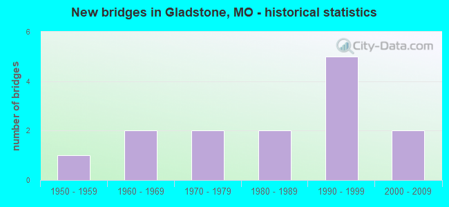
- New bridges - historical statistics
- 11950-1959
- 21960-1969
- 21970-1979
- 21980-1989
- 51990-1999
- 22000-2009
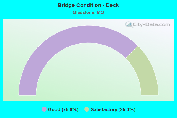
- Bridge Condition - Deck
- 75.0%Good
- 25.0%Satisfactory
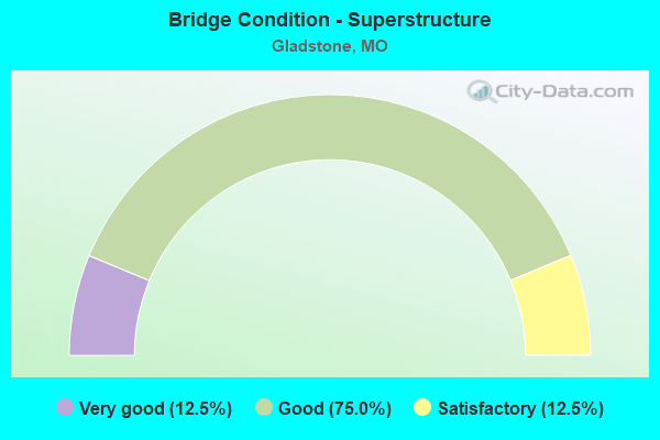
- Bridge Condition - Superstructure
- 12.5%Very good
- 75.0%Good
- 12.5%Satisfactory
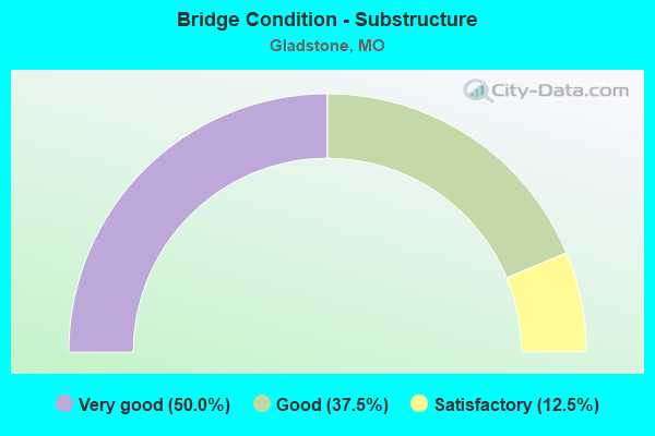
- Bridge Condition - Substructure
- 50.0%Very good
- 37.5%Good
- 12.5%Satisfactory
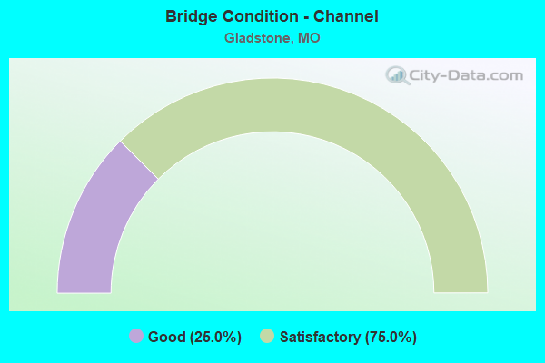
- Bridge Condition - Channel
- 25.0%Good
- 75.0%Satisfactory
Find on map >> Show street view
Structure Number: 11873, Location: S 22 T 51 N R 33 W (Lat: 39.217422, Lng: -94.589517), Route carried "on" structure: US 169, Year Built: 2000, Status: Open, Structure Length: 4.60m (15.09ft), Average Daily Traffic: 22,321 (year 2021), Truck Traffic: 4%, Average Future Daily Traffic: 40,178 (year 2041), Design Load: HS 20+Mod, Features Intersected: CST NW 68TH ST
Minimum Vertical Clearance: 30+ m (98+ ft), Kilometerpoint: 189.834, Lanes on structure: 2, Lanes under structure: 7, Base Highway Network: Yes, Owner: State Highway Agency, Approaching Roadway Width: 12.2m (40.0ft), Material/Design: Prestressed concrete continuous, Design/Construction: Stringer/Multi-beam, Number Of Spans In Main Unit: 3, Length of Maximum Span: 25.0m (82.0ft), Curb-To-Curb Width: 12.2m (40.0ft), Out-to-Out Width: 13.0m (42.7ft)
Condition: Deck: Good, Superstructure: Good, Substructure: Very good, Operating Rating: 71.1 metric tons, Method Used To Determine Operating Rating: Load Factor (LF), Inventory Rating: 43.2 metric tons, Method Used To Determine Inventory Rating: Load Factor (LF), Structural Evaluation: Better than present minimum criteria, Deck Geometry: Better than present minimum criteria, Underclear: High priority of corrective action, Approach Roadway Alignment: Equal to present desirable criteria, Designated Inspection Frequency: Every 24 months, Inspection Date: September 2020, Deck Structure Type: Concrete Cast-file-Place, Wearing Surface/Protective System: Wearing Surface: Monolithic Concrete, Deck Protection: Epoxy Coated Reinforcing
Find on map >> Show street view
Structure Number: 2489, Location: S 910 T 40 N R 5 E (Lat: 38.218239, Lng: -90.441922), Route carried "on" structure: State highway A, Year Built: 1974, Status: Open, Structure Length: 6.68m (21.92ft), Average Daily Traffic: 12,109 (year 2021), Truck Traffic: 4%, Average Future Daily Traffic: 20,585 (year 2041), Design Load: H 20, Features Intersected: CRD STATE HWY 21A OLD, U
Minimum Vertical Clearance: 30+ m (98+ ft), Kilometerpoint: 11.935, Lanes on structure: 2, Lanes under structure: 2, Owner: State Highway Agency, Approaching Roadway Width: 7.3m (24.0ft), Skew: 2 degrees, Material/Design: Prestressed concrete continuous, Design/Construction: Stringer/Multi-beam, Number Of Spans In Main Unit: 4, Length of Maximum Span: 18.9m (62.0ft), Curb-To-Curb Width: 13.4m (44.0ft), Out-to-Out Width: 14.3m (46.9ft)
Condition: Deck: Good, Superstructure: Satisfactory, Substructure: Good, Operating Rating: 61.2 metric tons, Method Used To Determine Operating Rating: Load Factor (LF), Inventory Rating: 27.0 metric tons, Method Used To Determine Inventory Rating: Load Factor (LF), Structural Evaluation: Equal to present minimum criteria, Deck Geometry: Equal to present minimum criteria, Underclear: Superior to present desirable criteria, Approach Roadway Alignment: Equal to present desirable criteria, Designated Inspection Frequency: Every 24 months, Inspection Date: November 2020, Deck Structure Type: Concrete Cast-file-Place, Wearing Surface/Protective System: Wearing Surface: Latex Concrete
Find on map >> Show street view
Structure Number: 28493, Location: S 18 T 52 N R 32 W (Lat: 39.228689, Lng: -94.534608), Route carried "on" structure: City street , Year Built: 1978, Status: Open, Structure Length: 4.82m (15.81ft), Average Daily Traffic: 5,000 (year 2020), Truck Traffic: 10%, Average Future Daily Traffic: 8,000 (year 2040), Design Load: HS 20, Features Intersected: SHOAL CR, Facility Carried by Structure: ANTIOCH RD
Minimum Vertical Clearance: 30+ m (98+ ft), Kilometerpoint: 2.092, Lanes on structure: 2, Owner: City or Municipal Highway Agency, Approaching Roadway Width: 9.1m (29.9ft), Skew: 4 degrees, Material/Design: Prestressed concrete continuous, Design/Construction: Stringer/Multi-beam, Number Of Spans In Main Unit: 3, Length of Maximum Span: 16.2m (53.1ft), Curb-To-Curb Width: 8.8m (28.9ft), Out-to-Out Width: 9.6m (31.5ft)
Condition: Deck: Satisfactory, Superstructure: Very good, Substructure: Very good, Channel: Good, Operating Rating: 75.6 metric tons, Method Used To Determine Operating Rating: Load Factor (LF), Inventory Rating: 45.9 metric tons, Method Used To Determine Inventory Rating: Load Factor (LF), Structural Evaluation: Equal to present desirable criteria, Deck Geometry: Meets minimum limits, Waterway Adequacy: Better than present minimum criteria, Approach Roadway Alignment: Equal to present desirable criteria, Designated Inspection Frequency: Every 24 months, Inspection Date: December 2021, Deck Structure Type: Concrete Precast Panels, Wearing Surface/Protective System: Wearing Surface: Monolithic Concrete, Deck Protection: Epoxy Coated Reinforcing
Find on map >> Show street view
Structure Number: 316, Location: S 175 T 30 N R 13 E (Lat: 37.290667, Lng: -89.574319), Route carried "on" structure: City street , Year Built: 1961, Status: Open, Structure Length: 7.25m (23.79ft), Average Daily Traffic: 7,417 (year 2021), Truck Traffic: 5%, Average Future Daily Traffic: 11,496 (year 2041), Design Load: H 15, Features Intersected: IS 55, Facility Carried by Structure: BLOOMFIELD RD E
Minimum Vertical Clearance: 30+ m (98+ ft), Kilometerpoint: 1.923, Lanes on structure: 2, Lanes under structure: 4, Owner: State Highway Agency, Approaching Roadway Width: 6.1m (20.0ft), Skew: 1 degrees, Material/Design: Steel continuous, Design/Construction: Stringer/Multi-beam, Number Of Spans In Main Unit: 4, Length of Maximum Span: 20.7m (67.9ft), Curb-To-Curb Width: 7.3m (24.0ft), Out-to-Out Width: 8.1m (26.6ft)
Condition: Deck: Satisfactory, Superstructure: Good, Substructure: Good, Operating Rating: 33.3 metric tons, Method Used To Determine Operating Rating: Allowable Stress (AS), Inventory Rating: 18.0 metric tons, Method Used To Determine Inventory Rating: Allowable Stress (AS), Structural Evaluation: Meets minimum limits, Deck Geometry: High priority of replacement, Underclear: Meets minimum limits, Approach Roadway Alignment: Equal to present minimum criteria, Length Of Structure Improvement: 0.83m (2.72ft), Designated Inspection Frequency: Every 24 months, Inspection Date: November 2021, Bridge Improvement Cost: $1,044,000, Roadway Improvement Cost: $104,000, Total Project Cost: $1,566,000 ( Estimate for 2022), Deck Structure Type: Concrete Cast-file-Place, Wearing Surface/Protective System: Wearing Surface: Monolithic Concrete, Deck Protection: Internally Sealed
Find on map >> Show street view
Structure Number: 316, Location: S 18 T 51 N R 32 W (Lat: 39.231414, Lng: -94.540894), Route carried "on" structure: State highway 1, Year Built: 1990, Status: Open, Structure Length: 11.22m (36.81ft), Average Daily Traffic: 19,475 (year 2021), Truck Traffic: 11%, Average Future Daily Traffic: 31,160 (year 2041), Design Load: HS 20+Mod, Features Intersected: SHOAL CR
Minimum Vertical Clearance: 30+ m (98+ ft), Kilometerpoint: 1.679, Lanes on structure: 4, Base Highway Network: Yes, Owner: State Highway Agency, Approaching Roadway Width: 21.9m (71.9ft), Material/Design: Prestressed concrete continuous, Design/Construction: Stringer/Multi-beam, Number Of Spans In Main Unit: 5, Length of Maximum Span: 25.3m (83.0ft), Curb or Sidewalk Widths: Left: 0.2m (0.7ft), Right: 0.2m (0.7ft), Curb-To-Curb Width: 21.6m (70.9ft), Out-to-Out Width: 22.4m (73.5ft)
Condition: Deck: Good, Superstructure: Good, Substructure: Satisfactory, Channel: Satisfactory, Operating Rating: 72.9 metric tons, Method Used To Determine Operating Rating: Load Factor (LF), Inventory Rating: 42.3 metric tons, Method Used To Determine Inventory Rating: Load Factor (LF), Structural Evaluation: Equal to present minimum criteria, Deck Geometry: Superior to present desirable criteria, Waterway Adequacy: Superior to present desirable criteria, Approach Roadway Alignment: Equal to present desirable criteria, Designated Inspection Frequency: Every 24 months, Inspection Date: September 2020, Deck Structure Type: Concrete Cast-file-Place, Wearing Surface/Protective System: Wearing Surface: Bituminous, Deck Protection: Epoxy Coated Reinforcing
Find on map >> Show street view
Structure Number: 3584, Location: S 22 T 51 N R 33 W (Lat: 39.217436, Lng: -94.589267), Route carried "on" structure: US 169, Year Built: 1985, Status: Open, Structure Length: 4.57m (14.99ft), Average Daily Traffic: 19,748 (year 2021), Truck Traffic: 9%, Average Future Daily Traffic: 35,546 (year 2041), Design Load: HS 20+Mod, Features Intersected: CST NW 68TH ST
Minimum Vertical Clearance: 30+ m (98+ ft), Kilometerpoint: 14.354, Lanes on structure: 2, Lanes under structure: 7, Base Highway Network: Yes, Owner: State Highway Agency, Approaching Roadway Width: 12.2m (40.0ft), Material/Design: Prestressed concrete continuous, Design/Construction: Stringer/Multi-beam, Number Of Spans In Main Unit: 3, Length of Maximum Span: 25.0m (82.0ft), Curb or Sidewalk Widths: Left: 0.2m (0.7ft), Right: 0.2m (0.7ft), Curb-To-Curb Width: 11.8m (38.7ft), Out-to-Out Width: 12.6m (41.3ft)
Condition: Deck: Good, Superstructure: Good, Substructure: Good, Operating Rating: 75.6 metric tons, Method Used To Determine Operating Rating: Load Factor (LF), Inventory Rating: 45.0 metric tons, Method Used To Determine Inventory Rating: Load Factor (LF), Structural Evaluation: Better than present minimum criteria, Deck Geometry: Equal to present minimum criteria, Underclear: High priority of corrective action, Approach Roadway Alignment: Equal to present desirable criteria, Designated Inspection Frequency: Every 24 months, Inspection Date: September 2020, Deck Structure Type: Concrete Cast-file-Place, Wearing Surface/Protective System: Wearing Surface: Monolithic Concrete, Deck Protection: Epoxy Coated Reinforcing
Find on map >> Show street view
Structure Number: 4357, Location: S 27 T 51 N R 33 W (Lat: 39.195789, Lng: -94.589828), Route carried "on" structure: US 169, Year Built: 1996, Status: Open, Structure Length: 3.99m (13.09ft), Average Daily Traffic: 19,761 (year 2021), Truck Traffic: 9%, Average Future Daily Traffic: 35,570 (year 2041), Design Load: HS 20+Mod, Features Intersected: CST NW ENGLEWOOD RD
Minimum Vertical Clearance: 30+ m (98+ ft), Kilometerpoint: 11.951, Lanes on structure: 2, Lanes under structure: 4, Base Highway Network: Yes, Owner: State Highway Agency, Approaching Roadway Width: 12.2m (40.0ft), Material/Design: Prestressed concrete continuous, Design/Construction: Stringer/Multi-beam, Number Of Spans In Main Unit: 3, Length of Maximum Span: 21.9m (71.9ft), Curb or Sidewalk Widths: Left: 0.2m (0.7ft), Right: 0.2m (0.7ft), Curb-To-Curb Width: 11.8m (38.7ft), Out-to-Out Width: 12.6m (41.3ft)
Condition: Deck: Good, Superstructure: Good, Substructure: Very good, Operating Rating: 98.1 metric tons, Method Used To Determine Operating Rating: Load Factor (LF), Inventory Rating: 59.4 metric tons, Method Used To Determine Inventory Rating: Load Factor (LF), Structural Evaluation: Better than present minimum criteria, Deck Geometry: Equal to present minimum criteria, Underclear: Equal to present minimum criteria, Approach Roadway Alignment: Equal to present desirable criteria, Designated Inspection Frequency: Every 24 months, Inspection Date: September 2020, Deck Structure Type: Concrete Cast-file-Place, Wearing Surface/Protective System: Wearing Surface: Monolithic Concrete, Deck Protection: Epoxy Coated Reinforcing
Find on map >> Show street view
Structure Number: 4358, Location: S 27 T 51 N R 33 W (Lat: 39.195772, Lng: -94.590100), Route carried "on" structure: US 169, Year Built: 1996, Status: Open, Structure Length: 3.99m (13.09ft), Average Daily Traffic: 35,368 (year 2021), Truck Traffic: 4%, Average Future Daily Traffic: 63,662 (year 2041), Design Load: HS 20+Mod, Features Intersected: CST NW ENGLEWOOD RD
Minimum Vertical Clearance: 30+ m (98+ ft), Kilometerpoint: 192.238, Lanes on structure: 2, Lanes under structure: 4, Base Highway Network: Yes, Owner: State Highway Agency, Approaching Roadway Width: 12.2m (40.0ft), Material/Design: Prestressed concrete continuous, Design/Construction: Stringer/Multi-beam, Number Of Spans In Main Unit: 3, Length of Maximum Span: 21.9m (71.9ft), Curb or Sidewalk Widths: Left: 0.2m (0.7ft), Right: 0.2m (0.7ft), Curb-To-Curb Width: 11.8m (38.7ft), Out-to-Out Width: 12.6m (41.3ft)
Condition: Deck: Good, Superstructure: Good, Substructure: Very good, Operating Rating: 98.1 metric tons, Method Used To Determine Operating Rating: Load Factor (LF), Inventory Rating: 59.4 metric tons, Method Used To Determine Inventory Rating: Load Factor (LF), Structural Evaluation: Better than present minimum criteria, Deck Geometry: Equal to present minimum criteria, Underclear: Equal to present minimum criteria, Approach Roadway Alignment: Equal to present desirable criteria, Designated Inspection Frequency: Every 24 months, Inspection Date: September 2020, Deck Structure Type: Concrete Cast-file-Place, Wearing Surface/Protective System: Wearing Surface: Monolithic Concrete, Deck Protection: Epoxy Coated Reinforcing
Find on map >> Show street view
Structure Number: 7891, Location: S 8 T 42 N R 22 W (Lat: 38.431769, Lng: -93.363944), Route carried "on" structure: State highway HH, Year Built: 1955, Status: Open, Structure Length: 0.61m (2.00ft), Average Daily Traffic: 204 (year 2021), Truck Traffic: 10%, Average Future Daily Traffic: 326 (year 2041), Design Load: H 10, Features Intersected: TEBO CR
Minimum Vertical Clearance: 30+ m (98+ ft), Kilometerpoint: 8.370, Lanes on structure: 2, Owner: State Highway Agency, Approaching Roadway Width: 7.3m (24.0ft), Skew: 2 degrees, Material/Design: Concrete continuous, Design/Construction: Culvert, Number Of Spans In Main Unit: 2, Length of Maximum Span: 2.7m (8.9ft), Curb-To-Curb Width: 8.7m (28.5ft), Out-to-Out Width: 9.3m (30.5ft)
Condition: Channel: Satisfactory, Culverts: Satisfactory, Operating Rating: 49.5 metric tons, Method Used To Determine Operating Rating: Load Factor (LF), Inventory Rating: 29.7 metric tons, Method Used To Determine Inventory Rating: Load Factor (LF), Structural Evaluation: Equal to present minimum criteria, Deck Geometry: Equal to present minimum criteria, Waterway Adequacy: Better than present minimum criteria, Approach Roadway Alignment: Equal to present minimum criteria, Designated Inspection Frequency: Every 24 months, Inspection Date: March 2021
Find on map >> Show street view
Structure Number: 828, Location: S 30 T 55 N R 20 W (Lat: 39.550281, Lng: -93.186828), Route carried "on" structure: State highway BB, Year Built: 1962, Status: Open, Structure Length: 0.70m (2.30ft), Average Daily Traffic: 56 (year 2021), Truck Traffic: 11%, Average Future Daily Traffic: 70 (year 2041), Design Load: H 15, Features Intersected: DRAIN DTCH
Minimum Vertical Clearance: 30+ m (98+ ft), Kilometerpoint: 0.356, Lanes on structure: 2, Owner: State Highway Agency, Approaching Roadway Width: 7.3m (24.0ft), Material/Design: Concrete continuous, Design/Construction: Culvert, Number Of Spans In Main Unit: 2, Length of Maximum Span: 3.4m (11.2ft), Curb-To-Curb Width: 7.9m (25.9ft), Out-to-Out Width: 8.5m (27.9ft)
Condition: Channel: Satisfactory, Culverts: Satisfactory, Operating Rating: 63.0 metric tons, Method Used To Determine Operating Rating: Load Factor (LF), Inventory Rating: 37.8 metric tons, Method Used To Determine Inventory Rating: Load Factor (LF), Structural Evaluation: Equal to present minimum criteria, Deck Geometry: Equal to present minimum criteria, Waterway Adequacy: Better than present minimum criteria, Approach Roadway Alignment: Equal to present desirable criteria, Designated Inspection Frequency: Every 24 months, Inspection Date: November 2020
Find on map >> Show street view
Structure Number: 11873, Location: S 22 T 51 N R 33 W (Lat: 39.217422, Lng: -94.589517), Route carried "under" structure: City street , Year Built: 2000, Structure Length: 0. m, Average Daily Traffic: 12,550 (year 2021), Truck Traffic: 2%, Features Intersected: CST NW 68TH ST, Facility Carried by Structure: US 169 S
Minimum Vertical Clearance: 4.47m (14.67ft), Kilometerpoint: 2.231, Lanes on structure: 2, Lanes under structure: 7, Material/Design: Prestressed concrete continuous, Design/Construction: Stringer/Multi-beam, Length of Maximum Span: 25.0m (82.0ft)
Find on map >> Show street view
Structure Number: 3584, Location: S 22 T 51 N R 33 W (Lat: 39.217436, Lng: -94.589267), Route carried "under" structure: City street , Year Built: 1985, Structure Length: 0. m, Average Daily Traffic: 14,145 (year 2021), Truck Traffic: 2%, Features Intersected: CST NW 68TH ST, Facility Carried by Structure: US 169 N
Minimum Vertical Clearance: 4.80m (15.75ft), Kilometerpoint: 2.251, Lanes on structure: 2, Lanes under structure: 7, Material/Design: Prestressed concrete continuous, Design/Construction: Stringer/Multi-beam, Length of Maximum Span: 25.0m (82.0ft)
Find on map >> Show street view
Structure Number: 4357, Location: S 27 T 51 N R 33 W (Lat: 39.195789, Lng: -94.589828), Route carried "under" structure: City street , Year Built: 1996, Structure Length: 0. m, Average Daily Traffic: 5,763 (year 2021), Truck Traffic: 2%, Features Intersected: CST NW ENGLEWOOD RD, Facility Carried by Structure: US 169 N
Minimum Vertical Clearance: 4.57m (14.99ft), Kilometerpoint: 1.514, Lanes on structure: 2, Lanes under structure: 4, Material/Design: Prestressed concrete continuous, Design/Construction: Stringer/Multi-beam, Length of Maximum Span: 21.9m (71.9ft)
Find on map >> Show street view
Structure Number: 4358, Location: S 27 T 51 N R 33 W (Lat: 39.195772, Lng: -94.590100), Route carried "under" structure: City street , Year Built: 1996, Structure Length: 0. m, Average Daily Traffic: 5,763 (year 2021), Truck Traffic: 2%, Features Intersected: CST NW ENGLEWOOD RD, Facility Carried by Structure: US 169 S
Minimum Vertical Clearance: 4.52m (14.83ft), Kilometerpoint: 1.490, Lanes on structure: 2, Lanes under structure: 4, Material/Design: Prestressed concrete continuous, Design/Construction: Stringer/Multi-beam, Length of Maximum Span: 21.9m (71.9ft)