Bridge Statistics for Gladstone, North Dakota (ND)
Condition, Traffic, Stress, Structural Evaluation, Project Costs
- National Bridge Inventory (NBI) Statistics
- 16Number of bridges
- 171ft / 52.3mTotal length
- $1,729,000Total costs
- 38,110Total average daily traffic
- 7,378Total average daily truck traffic
- National Bridge Inventory (NBI) Registered Bridges for Gladstone
- No street view available for this location
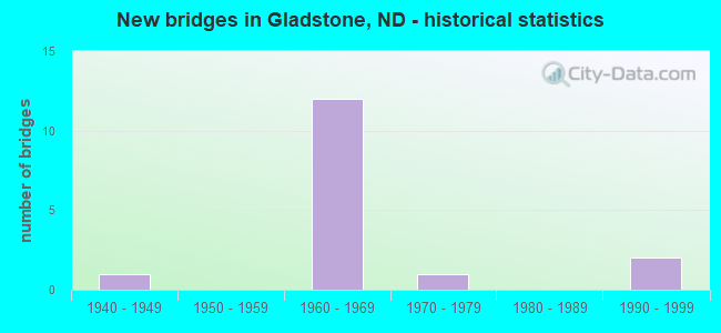
- New bridges - historical statistics
- 11940-1949
- 121960-1969
- 11970-1979
- 21990-1999


- Bridge Condition - Deck
- 50.0%Good
- 40.0%Satisfactory
- 10.0%Fair

- Bridge Condition - Superstructure
- 20.0%Very good
- 60.0%Good
- 20.0%Satisfactory

- Bridge Condition - Substructure
- 30.0%Good
- 30.0%Satisfactory
- 40.0%Fair

- Bridge Condition - Channel
- 33.3%Very good
- 16.7%Good
- 33.3%Satisfactory
- 16.7%Fair
Find on map >> Show street view
Structure Number: 4513008, Location: 7 EAST OF DICKINSON (Lat: 46.891892, Lng: -102.617533), Route carried "on" structure: County highway 4510, Year Built: 1949, Status: Open, Structure Length: 3.57m (11.71ft), Average Daily Traffic: 750 (year 2018), Truck Traffic: 10%, Average Future Daily Traffic: 850 (year 2038), Features Intersected: GREEN RIVER, Facility Carried by Structure: COUNTY HIGHWAY
Minimum Vertical Clearance: 30+ m (98+ ft), Kilometerpoint: 37.651, Lanes on structure: 2, Owner: County Highway Agency, Approaching Roadway Width: 9.8m (32.2ft), Material/Design: Steel, Design/Construction: Stringer/Multi-beam, Number Of Spans In Main Unit: 3, Length of Maximum Span: 11.3m (37.1ft), Curb or Sidewalk Widths: Left: 0.5m (1.6ft), Right: 0.5m (1.6ft), Curb-To-Curb Width: 9.8m (32.2ft), Out-to-Out Width: 11.3m (37.1ft)
Condition: Deck: Satisfactory, Superstructure: Satisfactory, Substructure: Satisfactory, Channel: Fair, Operating Rating: 51.5 metric tons, Method Used To Determine Operating Rating: Load Factor (LF), Inventory Rating: 31.0 metric tons, Method Used To Determine Inventory Rating: Load Factor (LF), Structural Evaluation: Equal to present minimum criteria, Deck Geometry: Equal to present minimum criteria, Waterway Adequacy: Better than present minimum criteria, Approach Roadway Alignment: Better than present minimum criteria, Length Of Structure Improvement: 3.57m (11.71ft), Designated Inspection Frequency: Every 24 months, Inspection Date: June 2021, Bridge Improvement Cost: $108,000, Roadway Improvement Cost: $11,000, Total Project Cost: $162,000, Deck Structure Type: Concrete Cast-file-Place, Wearing Surface/Protective System: Wearing Surface: Bituminous
Find on map >> Show street view
Structure Number: 4513211, Location: CITY OF GLADSTONE (Lat: 46.859058, Lng: -102.569644), Route carried "on" structure: County highway 4531, Year Built: 1990, Status: Open, Structure Length: 4.88m (16.01ft), Average Daily Traffic: 485 (year 2018), Truck Traffic: 10%, Average Future Daily Traffic: 700 (year 2038), Design Load: HS 20, Features Intersected: HEART RIVER, Facility Carried by Structure: Lee Avenue
Minimum Vertical Clearance: 30+ m (98+ ft), Kilometerpoint: 25.422, Lanes on structure: 2, Owner: County Highway Agency, Approaching Roadway Width: 9.8m (32.2ft), Material/Design: Prestressed concrete continuous, Design/Construction: Box Beam or Girders - Single/Spread, Number Of Spans In Main Unit: 3, Length of Maximum Span: 19.8m (65.0ft), Curb-To-Curb Width: 9.1m (29.9ft), Out-to-Out Width: 10.1m (33.1ft)
Condition: Deck: Good, Superstructure: Very good, Substructure: Good, Channel: Very good, Operating Rating: 40.5 metric tons, Method Used To Determine Operating Rating: Load Factor (LF), Inventory Rating: 17.0 metric tons, Method Used To Determine Inventory Rating: Load Factor (LF), Structural Evaluation: Somewhat better than minimum adequacy, Deck Geometry: Equal to present minimum criteria, Waterway Adequacy: Equal to present desirable criteria, Approach Roadway Alignment: Equal to present desirable criteria, Designated Inspection Frequency: Every 24 months, Inspection Date: June 2021, Deck Structure Type: Concrete Cast-file-Place, Wearing Surface/Protective System: Wearing Surface: Monolithic Concrete
Find on map >> Show street view
Structure Number: 4513214, Location: 4 SOUTH OF GLADSTONE (Lat: 46.803144, Lng: -102.568856), Route carried "on" structure: County highway 4531, Year Built: 1990, Status: Open, Structure Length: 3.84m (12.60ft), Average Daily Traffic: 485 (year 2018), Truck Traffic: 10%, Average Future Daily Traffic: 600 (year 2038), Design Load: HS 20, Features Intersected: ANTELOPE CREEK, Facility Carried by Structure: COUNTY HIGHWAY
Minimum Vertical Clearance: 30+ m (98+ ft), Kilometerpoint: 19.308, Lanes on structure: 2, Owner: County Highway Agency, Approaching Roadway Width: 9.8m (32.2ft), Material/Design: Prestressed concrete continuous, Design/Construction: Box Beam or Girders - Single/Spread, Number Of Spans In Main Unit: 3, Length of Maximum Span: 15.2m (49.9ft), Curb-To-Curb Width: 9.1m (29.9ft), Out-to-Out Width: 10.1m (33.1ft)
Condition: Deck: Good, Superstructure: Very good, Substructure: Good, Channel: Very good, Operating Rating: 89.8 metric tons, Method Used To Determine Operating Rating: Load Factor (LF), Inventory Rating: 36.9 metric tons, Method Used To Determine Inventory Rating: Load Factor (LF), Structural Evaluation: Better than present minimum criteria, Deck Geometry: Equal to present minimum criteria, Waterway Adequacy: Equal to present desirable criteria, Approach Roadway Alignment: Equal to present desirable criteria, Designated Inspection Frequency: Every 24 months, Inspection Date: June 2021, Deck Structure Type: Concrete Cast-file-Place, Wearing Surface/Protective System: Wearing Surface: Monolithic Concrete
Find on map >> Show street view
Structure Number: 4513314, Location: 3 SOUTH 2 EAST GLADSTONE (Lat: 46.814747, Lng: -102.539039), Route carried "on" structure: County highway , Year Built: 1973, Status: Open, Structure Length: 2.13m (6.99ft), Average Daily Traffic: 15 (year 2018), Average Future Daily Traffic: 15 (year 2038), Design Load: H 20, Features Intersected: ANTELOPE CREEK, Facility Carried by Structure: COUNTY HIGHWAY
Minimum Vertical Clearance: 30+ m (98+ ft), Kilometerpoint: 0.000, Lanes on structure: 2, Owner: County Highway Agency, Approaching Roadway Width: 5.5m (18.0ft), Material/Design: Prestressed concrete, Design/Construction: Box Beam or Girders - Multiple, Number Of Spans In Main Unit: 1, Length of Maximum Span: 20.7m (67.9ft), Curb-To-Curb Width: 6.8m (22.3ft), Out-to-Out Width: 7.5m (24.6ft)
Condition: Deck: Satisfactory, Superstructure: Satisfactory, Substructure: Satisfactory, Channel: Good, Operating Rating: 52.3 metric tons, Method Used To Determine Operating Rating: Load Factor (LF), Inventory Rating: 26.1 metric tons, Method Used To Determine Inventory Rating: Load Factor (LF), Structural Evaluation: Equal to present minimum criteria, Deck Geometry: Somewhat better than minimum adequacy, Waterway Adequacy: Better than present minimum criteria, Approach Roadway Alignment: Better than present minimum criteria, Designated Inspection Frequency: Every 24 months, Inspection Date: June 2021
Find on map >> Show street view
Structure Number: 94069714, Location: 8 EAST OF JCT. 22 (Lat: 46.876667, Lng: -102.621667), Route carried "on" structure: County highway , Year Built: 1963, Status: Open, Structure Length: 8.38m (27.49ft), Average Daily Traffic: 25 (year 2019), Average Future Daily Traffic: 25 (year 2039), Design Load: H 15, Features Intersected: I-94/GREEN RIVER SEP, Facility Carried by Structure: COUNTY ROAD
Minimum Vertical Clearance: 30+ m (98+ ft), Kilometerpoint: 0.000, Lanes on structure: 2, Lanes under structure: 4, Owner: State Highway Agency, Approaching Roadway Width: 6.7m (22.0ft), Material/Design: Steel continuous, Design/Construction: Stringer/Multi-beam, Number Of Spans In Main Unit: 5, Length of Maximum Span: 19.2m (63.0ft), Curb or Sidewalk Widths: Left: 0.5m (1.6ft), Right: 0.5m (1.6ft), Curb-To-Curb Width: 6.1m (20.0ft), Out-to-Out Width: 7.8m (25.6ft)
Condition: Deck: Satisfactory, Superstructure: Good, Substructure: Fair, Operating Rating: 56.2 metric tons, Method Used To Determine Operating Rating: Load Factor (LF), Inventory Rating: 33.6 metric tons, Method Used To Determine Inventory Rating: Load Factor (LF), Structural Evaluation: Somewhat better than minimum adequacy, Deck Geometry: High priority of replacement, Underclear: Somewhat better than minimum adequacy, Approach Roadway Alignment: Equal to present minimum criteria, Length Of Structure Improvement: 9.39m (30.81ft), Designated Inspection Frequency: Every 24 months, Other Special Inspection Frequency: Every 96 months, Inspection Date: May 2020, Other Special Inspection Date: November 2021, Bridge Improvement Cost: $655,000, Roadway Improvement Cost: $66,000, Total Project Cost: $983,000, Deck Structure Type: Concrete Cast-file-Place, Wearing Surface/Protective System: Wearing Surface: Monolithic Concrete
Find on map >> Show street view
Structure Number: 94070364 L, Location: 9 EAST OF JCT. 22 (Lat: 46.879425, Lng: -102.609064), Route carried "on" structure: Interstate 94, Year Built: 1963, Status: Open, Structure Length: 6.10m (20.01ft), Average Daily Traffic: 2,700 (year 2019), Truck Traffic: 19%, Average Future Daily Traffic: 2,700 (year 2039), Design Load: HS 20, Features Intersected: GREEN RIVER
Minimum Vertical Clearance: 30+ m (98+ ft), Kilometerpoint: 113.216, Lanes on structure: 2, Base Highway Network: Yes, Owner: State Highway Agency, Approaching Roadway Width: 11.3m (37.1ft), Material/Design: Prestressed concrete continuous, Design/Construction: Stringer/Multi-beam, Number Of Spans In Main Unit: 3, Length of Maximum Span: 20.1m (65.9ft), Curb-To-Curb Width: 11.3m (37.1ft), Out-to-Out Width: 13.0m (42.7ft)
Condition: Deck: Fair, Superstructure: Good, Substructure: Fair, Channel: Satisfactory, Operating Rating: 83.0 metric tons, Method Used To Determine Operating Rating: Load Factor (LF), Inventory Rating: 49.7 metric tons, Method Used To Determine Inventory Rating: Load Factor (LF), Structural Evaluation: Somewhat better than minimum adequacy, Deck Geometry: Somewhat better than minimum adequacy, Waterway Adequacy: Equal to present desirable criteria, Approach Roadway Alignment: Equal to present desirable criteria, Length Of Structure Improvement: 6.10m (20.01ft), Designated Inspection Frequency: Every 24 months, Inspection Date: May 2020, Bridge Improvement Cost: $213,000, Roadway Improvement Cost: $21,000, Total Project Cost: $320,000, Deck Structure Type: Concrete Cast-file-Place, Wearing Surface/Protective System: Wearing Surface: Latex Concrete
Find on map >> Show street view
Structure Number: 94070364 R, Location: 9 EAST OF JCT. 22 (Lat: 46.879197, Lng: -102.608911), Route carried "on" structure: Interstate 94, Year Built: 1963, Status: Open, Structure Length: 6.10m (20.01ft), Average Daily Traffic: 2,700 (year 2019), Truck Traffic: 19%, Average Future Daily Traffic: 2,700 (year 2039), Design Load: HS 20, Features Intersected: GREEN RIVER
Minimum Vertical Clearance: 30+ m (98+ ft), Kilometerpoint: 113.216, Lanes on structure: 2, Base Highway Network: Yes, Owner: State Highway Agency, Approaching Roadway Width: 11.3m (37.1ft), Material/Design: Prestressed concrete continuous, Design/Construction: Stringer/Multi-beam, Number Of Spans In Main Unit: 3, Length of Maximum Span: 20.1m (65.9ft), Curb-To-Curb Width: 11.6m (38.1ft), Out-to-Out Width: 13.0m (42.7ft)
Condition: Deck: Good, Superstructure: Good, Substructure: Fair, Channel: Satisfactory, Operating Rating: 83.0 metric tons, Method Used To Determine Operating Rating: Load Factor (LF), Inventory Rating: 49.7 metric tons, Method Used To Determine Inventory Rating: Load Factor (LF), Structural Evaluation: Somewhat better than minimum adequacy, Deck Geometry: Equal to present minimum criteria, Waterway Adequacy: Equal to present desirable criteria, Approach Roadway Alignment: Equal to present desirable criteria, Designated Inspection Frequency: Every 24 months, Inspection Date: May 2020, Deck Structure Type: Concrete Cast-file-Place, Wearing Surface/Protective System: Wearing Surface: Latex Concrete
Find on map >> Show street view
Structure Number: 94072253, Location: 13 WEST OF ND 8 (Lat: 46.878331, Lng: -102.569997), Route carried "on" structure: County highway 4531, Year Built: 1963, Year Reconstructed: 1992, Status: Open, Structure Length: 7.19m (23.59ft), Average Daily Traffic: 750 (year 2019), Truck Traffic: 14%, Average Future Daily Traffic: 825 (year 2039), Design Load: HS 20, Features Intersected: I-94/GLADSTONE INT., Facility Carried by Structure: COUNTY ROAD
Minimum Vertical Clearance: 30+ m (98+ ft), Kilometerpoint: 28.159, Lanes on structure: 2, Lanes under structure: 4, Owner: State Highway Agency, Approaching Roadway Width: 7.9m (25.9ft), Skew: 1 degrees, Material/Design: Prestressed concrete continuous, Design/Construction: Stringer/Multi-beam, Number Of Spans In Main Unit: 4, Length of Maximum Span: 21.3m (69.9ft), Curb-To-Curb Width: 9.1m (29.9ft), Out-to-Out Width: 9.9m (32.5ft)
Condition: Deck: Satisfactory, Superstructure: Good, Substructure: Good, Operating Rating: 84.3 metric tons, Method Used To Determine Operating Rating: Load Factor (LF), Inventory Rating: 50.4 metric tons, Method Used To Determine Inventory Rating: Load Factor (LF), Structural Evaluation: Better than present minimum criteria, Deck Geometry: Equal to present minimum criteria, Underclear: Equal to present minimum criteria, Approach Roadway Alignment: Equal to present desirable criteria, Designated Inspection Frequency: Every 24 months, Inspection Date: May 2020, Deck Structure Type: Concrete Cast-file-Place, Wearing Surface/Protective System: Wearing Surface: Monolithic Concrete, Deck Protection: Epoxy Coated Reinforcing
Find on map >> Show street view
Structure Number: 94073264 L, Location: 12 WEST OF ND 8 (Lat: 46.873333, Lng: -102.548333), Route carried "on" structure: Interstate 94, Year Built: 1962, Status: Open, Structure Length: 5.03m (16.50ft), Average Daily Traffic: 2,425 (year 2020), Truck Traffic: 21%, Average Future Daily Traffic: 2,425 (year 2040), Design Load: HS 20, Features Intersected: BNRR SEPARATION/MINOR RD
Minimum Vertical Clearance: 30+ m (98+ ft), Kilometerpoint: 117.882, Lanes on structure: 2, Lanes under structure: 2, Base Highway Network: Yes, Owner: State Highway Agency, Approaching Roadway Width: 11.3m (37.1ft), Skew: 1 degrees, Material/Design: Steel, Design/Construction: Stringer/Multi-beam, Number Of Spans In Main Unit: 3, Length of Maximum Span: 19.2m (63.0ft), Curb-To-Curb Width: 11.3m (37.1ft), Out-to-Out Width: 13.0m (42.7ft)
Condition: Deck: Good, Superstructure: Good, Substructure: Satisfactory, Operating Rating: 52.5 metric tons, Method Used To Determine Operating Rating: Load Factor (LF), Inventory Rating: 31.4 metric tons, Method Used To Determine Inventory Rating: Load Factor (LF), Structural Evaluation: Equal to present minimum criteria, Deck Geometry: Somewhat better than minimum adequacy, Underclear: Meets minimum limits, Approach Roadway Alignment: Better than present minimum criteria, Length Of Structure Improvement: 5.03m (16.50ft), Designated Inspection Frequency: Every 24 months, Inspection Date: May 2020, Bridge Improvement Cost: $176,000, Roadway Improvement Cost: $18,000, Total Project Cost: $264,000, Deck Structure Type: Concrete Cast-file-Place, Wearing Surface/Protective System: Wearing Surface: Low Slump Concrete
Find on map >> Show street view
Structure Number: 94073264 R, Location: 12 WEST OF JCT. ND 8 (Lat: 46.873719, Lng: -102.550178), Route carried "on" structure: Interstate 94, Year Built: 1963, Year Reconstructed: 1980, Status: Open, Structure Length: 5.03m (16.50ft), Average Daily Traffic: 2,425 (year 2020), Truck Traffic: 21%, Average Future Daily Traffic: 2,425 (year 2040), Design Load: HS 20, Features Intersected: BNRR SEPARATION/MINOR RD
Minimum Vertical Clearance: 30+ m (98+ ft), Kilometerpoint: 117.882, Lanes on structure: 2, Lanes under structure: 2, Base Highway Network: Yes, Owner: State Highway Agency, Approaching Roadway Width: 11.3m (37.1ft), Skew: 1 degrees, Material/Design: Steel continuous, Design/Construction: Stringer/Multi-beam, Number Of Spans In Main Unit: 3, Length of Maximum Span: 19.2m (63.0ft), Curb-To-Curb Width: 11.3m (37.1ft), Out-to-Out Width: 13.0m (42.7ft)
Condition: Deck: Good, Superstructure: Good, Substructure: Fair, Operating Rating: 52.5 metric tons, Method Used To Determine Operating Rating: Load Factor (LF), Inventory Rating: 31.4 metric tons, Method Used To Determine Inventory Rating: Load Factor (LF), Structural Evaluation: Somewhat better than minimum adequacy, Deck Geometry: Somewhat better than minimum adequacy, Underclear: Meets minimum limits, Approach Roadway Alignment: Equal to present desirable criteria, Designated Inspection Frequency: Every 24 months, Inspection Date: May 2020, Deck Structure Type: Concrete Cast-file-Place, Wearing Surface/Protective System: Wearing Surface: Low Slump Concrete
Find on map >> Show street view
Structure Number: 94069714, Location: 8 EAST OF JCT. 22 (Lat: 46.876667, Lng: -102.621667), Route carried "under" structure: Interstate 94, Year Built: 1963, Structure Length: 0. m, Average Daily Traffic: 5,400 (year 2011), Truck Traffic: 19%, Features Intersected: I-94/GREEN RIVER SEP, Facility Carried by Structure: COUNTY ROAD
Minimum Vertical Clearance: 4.93m (16.17ft), Kilometerpoint: 112.194, Lanes on structure: 2, Lanes under structure: 2, Material/Design: Steel continuous, Design/Construction: Stringer/Multi-beam, Length of Maximum Span: 19.2m (63.0ft)
Find on map >> Show street view
Structure Number: 94069714, Location: 8 EAST OF JCT. 22 (Lat: 46.876667, Lng: -102.621667), Route carried "under" structure: Interstate 94, Year Built: 1963, Structure Length: 0. m, Average Daily Traffic: 5,400 (year 2011), Truck Traffic: 19%, Features Intersected: I-94/GREEN RIVER SEP, Facility Carried by Structure: COUNTY ROAD
Minimum Vertical Clearance: 6.11m (20.05ft), Kilometerpoint: 112.194, Lanes on structure: 2, Lanes under structure: 2, Material/Design: Steel continuous, Design/Construction: Stringer/Multi-beam, Length of Maximum Span: 19.2m (63.0ft)
Find on map >> Show street view
Structure Number: 94072253, Location: 13 WEST OF ND 8 (Lat: 46.878331, Lng: -102.569997), Route carried "under" structure: Interstate 94, Year Built: 1963, Structure Length: 0. m, Average Daily Traffic: 4,850 (year 2011), Truck Traffic: 21%, Features Intersected: I-94/GLADSTONE INT., Facility Carried by Structure: COUNTY ROAD
Minimum Vertical Clearance: 5.05m (16.57ft), Kilometerpoint: 116.280, Lanes on structure: 2, Lanes under structure: 2, Material/Design: Prestressed concrete continuous, Design/Construction: Stringer/Multi-beam, Length of Maximum Span: 21.3m (69.9ft)
Find on map >> Show street view
Structure Number: 94072253, Location: 13 WEST OF ND 8 (Lat: 46.878331, Lng: -102.569997), Route carried "under" structure: Interstate 94, Year Built: 1963, Structure Length: 0. m, Average Daily Traffic: 4,850 (year 2011), Truck Traffic: 21%, Features Intersected: I-94/GLADSTONE INT., Facility Carried by Structure: COUNTY ROAD
Minimum Vertical Clearance: 5.29m (17.36ft), Kilometerpoint: 116.280, Lanes on structure: 2, Lanes under structure: 2, Material/Design: Prestressed concrete continuous, Design/Construction: Stringer/Multi-beam, Length of Maximum Span: 21.3m (69.9ft)
Find on map >> Show street view
Structure Number: 94073264 L, Location: 12 WEST OF ND 8 (Lat: 46.873333, Lng: -102.548333), Route carried "under" structure: Other road , Year Built: 1962, Structure Length: 0. m, Average Daily Traffic: 2,425 (year 2011), Truck Traffic: 20%, Features Intersected: BNRR SEPARATION/MINOR RD, Facility Carried by Structure: INTERSTATE 94
Minimum Vertical Clearance: 4.29m (14.07ft), Kilometerpoint: 0.000, Lanes on structure: 2, Lanes under structure: 2, Material/Design: Steel, Design/Construction: Stringer/Multi-beam, Length of Maximum Span: 19.2m (63.0ft)
Find on map >> Show street view
Structure Number: 94073264 R, Location: 12 WEST OF JCT. ND 8 (Lat: 46.873719, Lng: -102.550178), Route carried "under" structure: Other road , Year Built: 1963, Structure Length: 0. m, Average Daily Traffic: 2,425 (year 2011), Truck Traffic: 20%, Features Intersected: BNRR SEPARATION/MINOR RD, Facility Carried by Structure: INTERSTATE 94
Minimum Vertical Clearance: 4.29m (14.07ft), Kilometerpoint: 0.000, Lanes on structure: 2, Lanes under structure: 2, Material/Design: Steel continuous, Design/Construction: Stringer/Multi-beam, Length of Maximum Span: 19.2m (63.0ft)