Bridge Statistics for Glasgow, Missouri (MO)
Condition, Traffic, Stress, Structural Evaluation, Project Costs
- National Bridge Inventory (NBI) Statistics
- 17Number of bridges
- 476ft / 145mTotal length
- $2,515,000Total costs
- 10,606Total average daily traffic
- 1,354Total average daily truck traffic
- 13,610Total future (year 2040) average daily traffic
- National Bridge Inventory (NBI) Registered Bridges for Glasgow
- No street view available for this location
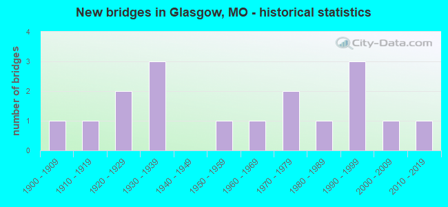
- New bridges - historical statistics
- 11900-1909
- 11910-1919
- 21920-1929
- 31930-1939
- 11950-1959
- 11960-1969
- 21970-1979
- 11980-1989
- 31990-1999
- 12000-2009
- 12010-2019

- Reconstructed bridges - Historical Statistics
- 11970-1979
- 31980-1989
- 01990-1999
- 12000-2009


- Bridge Condition - Deck
- 13.3%Very good
- 40.0%Good
- 26.7%Satisfactory
- 6.7%Fair
- 6.7%Poor
- 6.7%Serious

- Bridge Condition - Superstructure
- 6.7%Excellent
- 13.3%Very good
- 33.3%Good
- 33.3%Satisfactory
- 6.7%Fair
- 6.7%Poor

- Bridge Condition - Substructure
- 13.3%Excellent
- 6.7%Very good
- 13.3%Good
- 46.7%Satisfactory
- 20.0%Fair

- Bridge Condition - Channel
- 12.5%Good
- 50.0%Satisfactory
- 37.5%Fair

- Bridge Condition - Culverts
- 50.0%Satisfactory
- 50.0%Fair
Find on map >> Show street view
Structure Number: 11758, Location: S 10 T 51 N R 17 W (Lat: 39.229461, Lng: -92.803056), Route carried "on" structure: State highway 5, Year Built: 1996, Status: Open, Structure Length: 0.70m (2.30ft), Average Daily Traffic: 1,430 (year 2021), Truck Traffic: 20%, Average Future Daily Traffic: 1,859 (year 2041), Design Load: HS 20, Features Intersected: GREGGS CR
Minimum Vertical Clearance: 30+ m (98+ ft), Kilometerpoint: 195.291, Lanes on structure: 2, Base Highway Network: Yes, Owner: State Highway Agency, Approaching Roadway Width: 12.2m (40.0ft), Material/Design: Concrete continuous, Design/Construction: Culvert, Number Of Spans In Main Unit: 2, Length of Maximum Span: 3.4m (11.2ft)
Condition: Channel: Fair, Culverts: Satisfactory, Structural Evaluation: Equal to present minimum criteria, Waterway Adequacy: Equal to present desirable criteria, Approach Roadway Alignment: Equal to present desirable criteria, Designated Inspection Frequency: Every 24 months, Inspection Date: July 2021
Find on map >> Show street view
Structure Number: 11789, Location: S 32 T 52 N R 17 W (Lat: 39.270289, Lng: -92.850603), Route carried "on" structure: State highway 5, Year Built: 1999, Status: Open, Structure Length: 13.11m (43.01ft), Average Daily Traffic: 836 (year 2021), Truck Traffic: 6%, Average Future Daily Traffic: 1,087 (year 2041), Design Load: HS 20, Features Intersected: DOXIE CR
Minimum Vertical Clearance: 30+ m (98+ ft), Kilometerpoint: 184.420, Lanes on structure: 2, Base Highway Network: Yes, Owner: State Highway Agency, Approaching Roadway Width: 7.3m (24.0ft), Skew: 5 degrees, Material/Design: Prestressed concrete continuous, Design/Construction: Tee Beam, Number Of Spans In Main Unit: 4, Length of Maximum Span: 36.6m (120.1ft), Curb-To-Curb Width: 10.6m (34.8ft), Out-to-Out Width: 11.4m (37.4ft)
Condition: Deck: Good, Superstructure: Very good, Substructure: Excellent, Channel: Satisfactory, Operating Rating: 46.8 metric tons, Method Used To Determine Operating Rating: Load Factor (LF), Inventory Rating: 27.9 metric tons, Method Used To Determine Inventory Rating: Load Factor (LF), Structural Evaluation: Better than present minimum criteria, Deck Geometry: Equal to present minimum criteria, Waterway Adequacy: Equal to present desirable criteria, Approach Roadway Alignment: Equal to present desirable criteria, Designated Inspection Frequency: Every 24 months, Inspection Date: December 2020, Deck Structure Type: Concrete Cast-file-Place, Wearing Surface/Protective System: Deck Protection: Internally Sealed
Find on map >> Show street view
Structure Number: 158, Location: S 6 T 51 N R 17 W (Lat: 39.258247, Lng: -92.864031), Route carried "on" structure: State highway KK, Year Built: 1966, Year Reconstructed: 1986, Status: Open, Structure Length: 10.94m (35.89ft), Average Daily Traffic: 140 (year 2021), Truck Traffic: 9%, Average Future Daily Traffic: 175 (year 2041), Design Load: H 15, Features Intersected: LIT CHARITON RVR
Minimum Vertical Clearance: 30+ m (98+ ft), Kilometerpoint: 19.697, Lanes on structure: 2, Owner: State Highway Agency, Approaching Roadway Width: 6.4m (21.0ft), Skew: 1 degrees, Material/Design: Steel continuous, Design/Construction: Stringer/Multi-beam, Number Of Spans In Main Unit: 3, Number Of Approach Spans: 2, Length of Maximum Span: 30.5m (100.1ft), Curb-To-Curb Width: 7.9m (25.9ft), Out-to-Out Width: 8.7m (28.5ft)
Condition: Deck: Serious, Superstructure: Satisfactory, Substructure: Fair, Channel: Satisfactory, Operating Rating: 38.7 metric tons, Method Used To Determine Operating Rating: Load Factor (LF), Inventory Rating: 23.4 metric tons, Method Used To Determine Inventory Rating: Load Factor (LF), Structural Evaluation: Somewhat better than minimum adequacy, Deck Geometry: Somewhat better than minimum adequacy, Waterway Adequacy: Equal to present minimum criteria, Approach Roadway Alignment: Equal to present minimum criteria, Length Of Structure Improvement: 1.18m (3.87ft), Designated Inspection Frequency: Every 24 months, Inspection Date: May 2020, Bridge Improvement Cost: $821,000, Roadway Improvement Cost: $82,000, Total Project Cost: $1,231,000 ( Estimate for 2022), Deck Structure Type: Concrete Cast-file-Place, Wearing Surface/Protective System: Wearing Surface: Bituminous
Find on map >> Show street view
Structure Number: 17845, Location: S 17 T 51 N R 17 W (Lat: 39.220197, Lng: -92.846997), Route carried "on" structure: City street 164, Year Built: 1933, Status: Posted for load, Structure Length: 4.05m (13.29ft), Average Daily Traffic: 100 (year 2020), Truck Traffic: 10%, Average Future Daily Traffic: 110 (year 2040), Features Intersected: GREGGS CR, Facility Carried by Structure: SECOND ST
Minimum Vertical Clearance: 30+ m (98+ ft), Kilometerpoint: 0.161, Lanes on structure: 2, Owner: City or Municipal Highway Agency, Approaching Roadway Width: 7.3m (24.0ft), Material/Design: Steel, Design/Construction: Stringer/Multi-beam, Number Of Spans In Main Unit: 3, Length of Maximum Span: 12.8m (42.0ft), Curb-To-Curb Width: 6.2m (20.3ft), Out-to-Out Width: 6.5m (21.3ft)
Condition: Deck: Satisfactory, Superstructure: Good, Substructure: Satisfactory, Channel: Fair, Operating Rating: 24.3 metric tons, Method Used To Determine Operating Rating: Load Factor (LF), Inventory Rating: 14.4 metric tons, Method Used To Determine Inventory Rating: Load Factor (LF), Structural Evaluation: Meets minimum limits, Deck Geometry: Somewhat better than minimum adequacy, Waterway Adequacy: Better than present minimum criteria, Approach Roadway Alignment: Equal to present minimum criteria, Bridge Posting: Required (Relationship of Operating Rating to Maximum Legal Load: 20.0 - 29.9% below), Designated Inspection Frequency: Every 24 months, Inspection Date: Febuary 2020, Deck Structure Type: Concrete Cast-file-Place, Wearing Surface/Protective System: Wearing Surface: Monolithic Concrete
Find on map >> Show street view
Structure Number: 18796, Location: S 1 T 51 N R 17 W (Lat: 39.256942, Lng: -92.772861), Route carried "on" structure: County highway 200, Year Built: 1994, Status: Open, Structure Length: 2.74m (8.99ft), Average Daily Traffic: 35 (year 2020), Truck Traffic: 10%, Average Future Daily Traffic: 39 (year 2040), Features Intersected: DOXIES CR, Facility Carried by Structure: COUNTY RD 239
Minimum Vertical Clearance: 30+ m (98+ ft), Kilometerpoint: 0.322, Lanes on structure: 2, Owner: County Highway Agency, Approaching Roadway Width: 4.3m (14.1ft), Skew: 4 degrees, Material/Design: Steel, Design/Construction: Stringer/Multi-beam, Number Of Spans In Main Unit: 2, Length of Maximum Span: 23.2m (76.1ft), Curb-To-Curb Width: 5.6m (18.4ft), Out-to-Out Width: 5.8m (19.0ft)
Condition: Deck: Good, Superstructure: Good, Substructure: Satisfactory, Channel: Fair, Operating Rating: 34.2 metric tons, Method Used To Determine Operating Rating: Allowable Stress (AS), Inventory Rating: 20.7 metric tons, Method Used To Determine Inventory Rating: Allowable Stress (AS), Structural Evaluation: Equal to present minimum criteria, Deck Geometry: Meets minimum limits, Waterway Adequacy: Better than present minimum criteria, Approach Roadway Alignment: Equal to present minimum criteria, Designated Inspection Frequency: Every 24 months, Inspection Date: Febuary 2020, Deck Structure Type: Concrete Cast-file-Place
Find on map >> Show street view
Structure Number: 18955, Location: S 27 T 52 N R 17 W (Lat: 39.274861, Lng: -92.810944), Route carried "on" structure: County highway 205, Year Built: 1900, Year Reconstructed: 1987, Status: Open, Structure Length: 3.75m (12.30ft), Average Daily Traffic: 70 (year 2020), Truck Traffic: 10%, Average Future Daily Traffic: 77 (year 2040), Features Intersected: DOXIES CR, Facility Carried by Structure: COUNTY RD 248
Minimum Vertical Clearance: 30+ m (98+ ft), Kilometerpoint: 3.541, Lanes on structure: 2, Owner: County Highway Agency, Approaching Roadway Width: 6.1m (20.0ft), Material/Design: Prestressed concrete continuous, Design/Construction: Tee Beam, Number Of Spans In Main Unit: 3, Length of Maximum Span: 12.2m (40.0ft), Curb-To-Curb Width: 7.3m (24.0ft), Out-to-Out Width: 7.9m (25.9ft)
Condition: Deck: Good, Superstructure: Satisfactory, Substructure: Good, Channel: Satisfactory, Operating Rating: 49.5 metric tons, Method Used To Determine Operating Rating: Allowable Stress (AS), Inventory Rating: 22.5 metric tons, Method Used To Determine Inventory Rating: Allowable Stress (AS), Structural Evaluation: Equal to present minimum criteria, Deck Geometry: Equal to present minimum criteria, Waterway Adequacy: Better than present minimum criteria, Approach Roadway Alignment: Equal to present minimum criteria, Designated Inspection Frequency: Every 24 months, Inspection Date: Febuary 2020, Deck Structure Type: Concrete Cast-file-Place, Wearing Surface/Protective System: Wearing Surface: Monolithic Concrete
Find on map >> Show street view
Structure Number: 237, Location: S 1 T 24 N R 17 E (Lat: 36.751397, Lng: -89.264994), Route carried "on" structure: State highway FF, Year Built: 1958, Status: Open, Structure Length: 3.44m (11.29ft), Average Daily Traffic: 68 (year 2021), Truck Traffic: 9%, Average Future Daily Traffic: 95 (year 2041), Design Load: H 15, Features Intersected: DRAIN DTCH #29
Minimum Vertical Clearance: 30+ m (98+ ft), Kilometerpoint: 0.433, Lanes on structure: 2, Owner: State Highway Agency, Approaching Roadway Width: 5.5m (18.0ft), Material/Design: Steel, Design/Construction: Stringer/Multi-beam, Number Of Spans In Main Unit: 3, Length of Maximum Span: 12.5m (41.0ft), Curb-To-Curb Width: 6.7m (22.0ft), Out-to-Out Width: 7.5m (24.6ft)
Condition: Deck: Satisfactory, Superstructure: Good, Substructure: Satisfactory, Channel: Fair, Operating Rating: 29.7 metric tons, Method Used To Determine Operating Rating: Allowable Stress (AS), Inventory Rating: 17.1 metric tons, Method Used To Determine Inventory Rating: Allowable Stress (AS), Structural Evaluation: Somewhat better than minimum adequacy, Deck Geometry: Somewhat better than minimum adequacy, Waterway Adequacy: Somewhat better than minimum adequacy, Approach Roadway Alignment: Equal to present desirable criteria, Designated Inspection Frequency: Every 24 months, Inspection Date: November 2021, Deck Structure Type: Concrete Cast-file-Place, Wearing Surface/Protective System: Wearing Surface: Bituminous, Membrane: Built-up
Find on map >> Show street view
Structure Number: 237, Location: S 17 T 51 N R 17 W (Lat: 39.219892, Lng: -92.843333), Route carried "on" structure: State highway 5, Year Built: 1972, Status: Open, Structure Length: 7.86m (25.79ft), Average Daily Traffic: 1,997 (year 2021), Truck Traffic: 13%, Average Future Daily Traffic: 2,596 (year 2041), Design Load: H 20, Features Intersected: GREGGS CR
Minimum Vertical Clearance: 30+ m (98+ ft), Kilometerpoint: 190.933, Lanes on structure: 2, Base Highway Network: Yes, Owner: State Highway Agency, Approaching Roadway Width: 7.3m (24.0ft), Skew: 2 degrees, Material/Design: Prestressed concrete continuous, Design/Construction: Stringer/Multi-beam, Number Of Spans In Main Unit: 6, Length of Maximum Span: 15.2m (49.9ft), Curb-To-Curb Width: 12.2m (40.0ft), Out-to-Out Width: 13.0m (42.7ft)
Condition: Deck: Satisfactory, Superstructure: Good, Substructure: Fair, Channel: Fair, Operating Rating: 54.9 metric tons, Method Used To Determine Operating Rating: Load Factor (LF), Inventory Rating: 33.3 metric tons, Method Used To Determine Inventory Rating: Load Factor (LF), Structural Evaluation: Somewhat better than minimum adequacy, Deck Geometry: Better than present minimum criteria, Waterway Adequacy: Equal to present desirable criteria, Approach Roadway Alignment: Equal to present desirable criteria, Designated Inspection Frequency: Every 24 months, Inspection Date: June 2021, Deck Structure Type: Concrete Cast-file-Place, Wearing Surface/Protective System: Wearing Surface: Epoxy Overlay
Find on map >> Show street view
Structure Number: 2371, Location: S 21 T 51 N R 17 W (Lat: 39.205808, Lng: -92.840417), Route carried "on" structure: State highway 87, Year Built: 1972, Status: Open, Structure Length: 4.63m (15.19ft), Average Daily Traffic: 885 (year 2021), Truck Traffic: 12%, Average Future Daily Traffic: 1,106 (year 2041), Design Load: H 15, Features Intersected: HURRICANE CR
Minimum Vertical Clearance: 30+ m (98+ ft), Kilometerpoint: 2.082, Lanes on structure: 2, Owner: State Highway Agency, Approaching Roadway Width: 6.7m (22.0ft), Skew: 3 degrees, Material/Design: Prestressed concrete continuous, Design/Construction: Stringer/Multi-beam, Number Of Spans In Main Unit: 3, Length of Maximum Span: 15.5m (50.9ft), Curb-To-Curb Width: 10.4m (34.1ft), Out-to-Out Width: 12.2m (40.0ft)
Condition: Deck: Satisfactory, Superstructure: Satisfactory, Substructure: Satisfactory, Channel: Satisfactory, Operating Rating: 44.1 metric tons, Method Used To Determine Operating Rating: Load Factor (LF), Inventory Rating: 26.1 metric tons, Method Used To Determine Inventory Rating: Load Factor (LF), Structural Evaluation: Equal to present minimum criteria, Deck Geometry: Equal to present minimum criteria, Waterway Adequacy: Equal to present desirable criteria, Approach Roadway Alignment: Equal to present desirable criteria, Designated Inspection Frequency: Every 24 months, Inspection Date: June 2021, Deck Structure Type: Concrete Cast-file-Place, Wearing Surface/Protective System: Wearing Surface: Epoxy Overlay, Deck Protection: Internally Sealed
Find on map >> Show street view
Structure Number: 24961, Location: S 22 T 52 N R 17 W (Lat: 39.292686, Lng: -92.816808), Route carried "on" structure: County highway 587, Year Built: 1910, Year Reconstructed: 1989, Status: Open, Structure Length: 1.83m (6.00ft), Average Daily Traffic: 35 (year 2021), Truck Traffic: 10%, Average Future Daily Traffic: 39 (year 2041), Features Intersected: BATTS CR, Facility Carried by Structure: HOWARD AVE
Minimum Vertical Clearance: 30+ m (98+ ft), Kilometerpoint: 0.483, Lanes on structure: 2, Owner: County Highway Agency, Approaching Roadway Width: 6.1m (20.0ft), Material/Design: Steel, Design/Construction: Stringer/Multi-beam, Number Of Spans In Main Unit: 1, Length of Maximum Span: 18.0m (59.1ft), Curb-To-Curb Width: 6.8m (22.3ft), Out-to-Out Width: 6.8m (22.3ft)
Condition: Deck: Good, Superstructure: Satisfactory, Substructure: Good, Channel: Satisfactory, Operating Rating: 47.7 metric tons, Method Used To Determine Operating Rating: Allowable Stress (AS), Inventory Rating: 29.7 metric tons, Method Used To Determine Inventory Rating: Allowable Stress (AS), Structural Evaluation: Equal to present minimum criteria, Deck Geometry: Somewhat better than minimum adequacy, Waterway Adequacy: Equal to present minimum criteria, Approach Roadway Alignment: Meets minimum limits, Designated Inspection Frequency: Every 24 months, Inspection Date: September 2020, Deck Structure Type: Concrete Cast-file-Place
Find on map >> Show street view
Structure Number: 29358, Location: S 28 T 52 N R 17 W (Lat: 39.286222, Lng: -92.840472), Route carried "on" structure: County highway 589, Year Built: 2002, Status: Open, Structure Length: 3.57m (11.71ft), Average Daily Traffic: 40 (year 2021), Truck Traffic: 10%, Average Future Daily Traffic: 44 (year 2041), Design Load: HS 20, Features Intersected: BATTS CR, Facility Carried by Structure: DOXIE AVE
Minimum Vertical Clearance: 30+ m (98+ ft), Kilometerpoint: 0.322, Lanes on structure: 2, Owner: County Highway Agency, Approaching Roadway Width: 7.3m (24.0ft), Skew: 1 degrees, Material/Design: Prestressed concrete continuous, Design/Construction: Tee Beam, Number Of Spans In Main Unit: 3, Length of Maximum Span: 11.9m (39.0ft), Curb-To-Curb Width: 7.3m (24.0ft), Out-to-Out Width: 7.5m (24.6ft)
Condition: Deck: Very good, Superstructure: Good, Substructure: Very good, Channel: Satisfactory, Operating Rating: 56.7 metric tons, Method Used To Determine Operating Rating: Load Factor (LF), Inventory Rating: 34.2 metric tons, Method Used To Determine Inventory Rating: Load Factor (LF), Structural Evaluation: Better than present minimum criteria, Deck Geometry: Equal to present minimum criteria, Waterway Adequacy: Equal to present minimum criteria, Approach Roadway Alignment: Equal to present minimum criteria, Designated Inspection Frequency: Every 24 months, Inspection Date: September 2020, Deck Structure Type: Concrete Cast-file-Place, Wearing Surface/Protective System: Wearing Surface: Monolithic Concrete
Find on map >> Show street view
Structure Number: 35827, Location: S 2463 T 52 N R 17 W (Lat: 39.260569, Lng: -92.794361), Route carried "on" structure: State highway V, Year Built: 2018, Status: Open, Structure Length: 3.37m (11.06ft), Average Daily Traffic: 208 (year 2021), Truck Traffic: 11%, Average Future Daily Traffic: 260 (year 2041), Features Intersected: DOXIES CR
Minimum Vertical Clearance: 30+ m (98+ ft), Kilometerpoint: 4.728, Lanes on structure: 2, Owner: State Highway Agency, Approaching Roadway Width: 7.9m (25.9ft), Skew: 1 degrees, Material/Design: Prestressed concrete, Design/Construction: Tee Beam, Number Of Spans In Main Unit: 1, Length of Maximum Span: 32.6m (107.0ft), Curb-To-Curb Width: 7.9m (25.9ft), Out-to-Out Width: 8.7m (28.5ft)
Condition: Deck: Very good, Superstructure: Excellent, Substructure: Excellent, Channel: Good, Operating Rating: 84.6 metric tons, Method Used To Determine Operating Rating: Load Factor (LF), Inventory Rating: 30.6 metric tons, Method Used To Determine Inventory Rating: Load Factor (LF), Structural Evaluation: Better than present minimum criteria, Deck Geometry: Somewhat better than minimum adequacy, Waterway Adequacy: Superior to present desirable criteria, Approach Roadway Alignment: Equal to present desirable criteria, Designated Inspection Frequency: Every 24 months, Inspection Date: June 2021, Deck Structure Type: Concrete Precast Panels, Wearing Surface/Protective System: Wearing Surface: Monolithic Concrete, Deck Protection: Epoxy Coated Reinforcing
Find on map >> Show street view
Structure Number: 3605, Location: S 4 T 50 N R 17 W (Lat: 39.163606, Lng: -92.841519), Route carried "on" structure: State highway 87, Year Built: 1985, Status: Open, Structure Length: 3.96m (12.99ft), Average Daily Traffic: 679 (year 2021), Truck Traffic: 11%, Average Future Daily Traffic: 849 (year 2041), Design Load: HS 20, Features Intersected: BLUE CR
Minimum Vertical Clearance: 30+ m (98+ ft), Kilometerpoint: 6.790, Lanes on structure: 2, Owner: State Highway Agency, Approaching Roadway Width: 6.7m (22.0ft), Skew: 2 degrees, Material/Design: Prestressed concrete continuous, Design/Construction: Tee Beam, Number Of Spans In Main Unit: 3, Length of Maximum Span: 13.3m (43.6ft), Curb or Sidewalk Widths: Left: 0.2m (0.7ft), Right: 0.2m (0.7ft), Curb-To-Curb Width: 10.0m (32.8ft), Out-to-Out Width: 10.8m (35.4ft)
Condition: Deck: Good, Superstructure: Satisfactory, Substructure: Satisfactory, Channel: Fair, Operating Rating: 43.2 metric tons, Method Used To Determine Operating Rating: Load Factor (LF), Inventory Rating: 26.1 metric tons, Method Used To Determine Inventory Rating: Load Factor (LF), Structural Evaluation: Equal to present minimum criteria, Deck Geometry: Equal to present minimum criteria, Waterway Adequacy: Equal to present minimum criteria, Approach Roadway Alignment: Equal to present desirable criteria, Designated Inspection Frequency: Every 24 months, Inspection Date: June 2021, Deck Structure Type: Concrete Cast-file-Place, Wearing Surface/Protective System: Wearing Surface: Epoxy Overlay, Deck Protection: Internally Sealed
Find on map >> Show street view
Structure Number: 4814, Location: S 3 T 51 N R 18 W (Lat: 39.222547, Lng: -92.851364), Route carried "on" structure: State highway 240, Year Built: 1922, Year Reconstructed: 2008, Status: Open, Structure Length: 67.73m (222.21ft), Average Daily Traffic: 1,305 (year 2021), Truck Traffic: 26%, Average Future Daily Traffic: 1,697 (year 2041), Features Intersected: MISSOURI RVR, KCS RR
Minimum Vertical Clearance: 30+ m (98+ ft), Kilometerpoint: 40.977, Lanes on structure: 2, Base Highway Network: Yes, Owner: State Highway Agency, Approaching Roadway Width: 7.9m (25.9ft), Navigation Control: Yes ( Vertical Clearance: 16.8m (55.1ft), Horizontal Clearance: 98.9m (324.5ft)), Material/Design: Steel continuous, Design/Construction: Stringer/Multi-beam, Number Of Spans In Main Unit: 3, Number Of Approach Spans: 9, Length of Maximum Span: 104.9m (344.2ft), Curb-To-Curb Width: 7.9m (25.9ft), Out-to-Out Width: 8.7m (28.5ft)
Condition: Deck: Good, Superstructure: Very good, Substructure: Satisfactory, Channel: Good, Operating Rating: 67.5 metric tons, Method Used To Determine Operating Rating: Load Factor (LF), Inventory Rating: 40.5 metric tons, Method Used To Determine Inventory Rating: Load Factor (LF), Structural Evaluation: Equal to present minimum criteria, Deck Geometry: Meets minimum limits, Underclear: Somewhat better than minimum adequacy, Waterway Adequacy: Equal to present desirable criteria, Approach Roadway Alignment: Equal to present minimum criteria, Designated Inspection Frequency: Every 24 months, Underwater Inspection Frequency: Every 60 months, Inspection Date: September 2021, Underwater Inspection Date: July 2020, Deck Structure Type: Concrete Cast-file-Place, Wearing Surface/Protective System: Wearing Surface: Monolithic Concrete, Deck Protection: Epoxy Coated Reinforcing
Find on map >> Show street view
Structure Number: 5092, Location: S 32 T 52 N R 17 W (Lat: 39.261683, Lng: -92.853242), Route carried "on" structure: State highway 5, Year Built: 1928, Status: Open, Structure Length: 0.76m (2.49ft), Average Daily Traffic: 836 (year 2021), Truck Traffic: 6%, Average Future Daily Traffic: 1,087 (year 2041), Design Load: H 15, Features Intersected: BR LIT CHARITON CR
Minimum Vertical Clearance: 30+ m (98+ ft), Kilometerpoint: 185.458, Lanes on structure: 2, Base Highway Network: Yes, Owner: State Highway Agency, Approaching Roadway Width: 9.1m (29.9ft), Material/Design: Concrete continuous, Design/Construction: Culvert, Number Of Spans In Main Unit: 2, Length of Maximum Span: 3.7m (12.1ft), Curb-To-Curb Width: 10.4m (34.1ft), Out-to-Out Width: 11.0m (36.1ft)
Condition: Channel: Satisfactory, Culverts: Fair, Operating Rating: 90.0 metric tons, Method Used To Determine Operating Rating: Load Factor (LF), Inventory Rating: 54.0 metric tons, Method Used To Determine Inventory Rating: Load Factor (LF), Structural Evaluation: Somewhat better than minimum adequacy, Deck Geometry: Equal to present minimum criteria, Waterway Adequacy: Equal to present minimum criteria, Approach Roadway Alignment: Better than present minimum criteria, Designated Inspection Frequency: Every 24 months, Inspection Date: November 2020
Find on map >> Show street view
Structure Number: 5213, Location: S 8 T 51 N R 17 W (Lat: 39.232428, Lng: -92.844250), Route carried "on" structure: State highway 5, Year Built: 1930, Year Reconstructed: 1970, Status: Open, Structure Length: 6.49m (21.29ft), Average Daily Traffic: 1,251 (year 2021), Truck Traffic: 6%, Average Future Daily Traffic: 1,626 (year 2041), Design Load: H 15, Features Intersected: BEAR CR
Minimum Vertical Clearance: 30+ m (98+ ft), Kilometerpoint: 189.153, Lanes on structure: 2, Base Highway Network: Yes, Owner: State Highway Agency, Approaching Roadway Width: 6.1m (20.0ft), Material/Design: Concrete, Design/Construction: Tee Beam, Number Of Spans In Main Unit: 5, Length of Maximum Span: 13.0m (42.7ft), Curb or Sidewalk Widths: Left: 0.0m, Right: 1.2m (3.9ft), Curb-To-Curb Width: 6.8m (22.3ft), Out-to-Out Width: 7.0m (23.0ft)
Condition: Deck: Poor, Superstructure: Poor, Substructure: Satisfactory, Channel: Satisfactory, Operating Rating: 45.0 metric tons, Method Used To Determine Operating Rating: Allowable Stress (AS), Inventory Rating: 23.4 metric tons, Method Used To Determine Inventory Rating: Allowable Stress (AS), Structural Evaluation: Meets minimum limits, Deck Geometry: High priority of corrective action, Waterway Adequacy: Equal to present minimum criteria, Approach Roadway Alignment: Equal to present desirable criteria, Length Of Structure Improvement: 0.75m (2.46ft), Designated Inspection Frequency: Every 24 months, Inspection Date: June 2021, Bridge Improvement Cost: $856,000, Roadway Improvement Cost: $86,000, Total Project Cost: $1,284,000 ( Estimate for 2022), Deck Structure Type: Concrete Cast-file-Place, Wearing Surface/Protective System: Wearing Surface: Bituminous, Membrane: Built-up
Find on map >> Show street view
Structure Number: 5794, Location: S 11 T 51 N R 17 W (Lat: 39.234606, Lng: -92.795500), Route carried "on" structure: Business State highway 240, Year Built: 1934, Status: Open, Structure Length: 6.04m (19.82ft), Average Daily Traffic: 691 (year 2021), Truck Traffic: 7%, Average Future Daily Traffic: 864 (year 2041), Design Load: H 15, Features Intersected: KCS RR
Minimum Vertical Clearance: 30+ m (98+ ft), Kilometerpoint: 5.629, Lanes on structure: 2, Owner: State Highway Agency, Approaching Roadway Width: 6.7m (22.0ft), Skew: 4 degrees, Material/Design: Concrete, Design/Construction: Tee Beam, Number Of Spans In Main Unit: 5, Length of Maximum Span: 14.5m (47.6ft), Curb-To-Curb Width: 8.0m (26.2ft), Out-to-Out Width: 8.2m (26.9ft)
Condition: Deck: Fair, Superstructure: Fair, Substructure: Fair, Operating Rating: 45.9 metric tons, Method Used To Determine Operating Rating: Load Factor (LF), Inventory Rating: 27.9 metric tons, Method Used To Determine Inventory Rating: Load Factor (LF), Structural Evaluation: Somewhat better than minimum adequacy, Deck Geometry: Somewhat better than minimum adequacy, Underclear: Meets minimum limits, Approach Roadway Alignment: Somewhat better than minimum adequacy, Designated Inspection Frequency: Every 24 months, Inspection Date: June 2021, Deck Structure Type: Concrete Cast-file-Place, Wearing Surface/Protective System: Wearing Surface: Bituminous