Bridge Statistics for Glasgow, Virginia (VA)
Condition, Traffic, Stress, Structural Evaluation, Project Costs
- National Bridge Inventory (NBI) Statistics
- 26Number of bridges
- 364ft / 111mTotal length
- $5,805,000Total costs
- 141,956Total average daily traffic
- 27,843Total average daily truck traffic
- National Bridge Inventory (NBI) Registered Bridges for Glasgow
- No street view available for this location
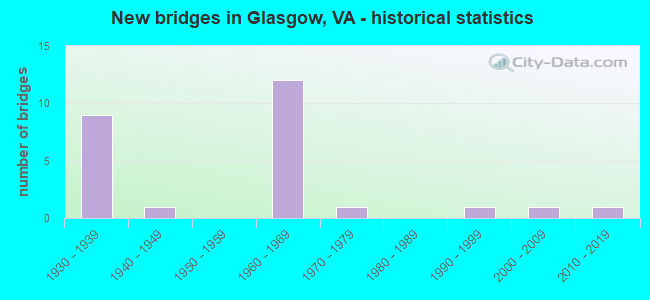
- New bridges - historical statistics
- 91930-1939
- 11940-1949
- 121960-1969
- 11970-1979
- 11990-1999
- 12000-2009
- 12010-2019


- Bridge Condition - Deck
- 11.1%Very good
- 27.8%Good
- 38.9%Satisfactory
- 22.2%Fair

- Bridge Condition - Superstructure
- 5.6%Very good
- 27.8%Good
- 44.4%Satisfactory
- 22.2%Fair

- Bridge Condition - Substructure
- 33.3%Good
- 33.3%Satisfactory
- 33.3%Fair

- Bridge Condition - Channel
- 7.1%Very good
- 28.6%Good
- 42.9%Satisfactory
- 21.4%Fair

- Bridge Condition - Culverts
- 50.0%Good
- 50.0%Fair
Find on map >> Show street view
Structure Number: 15281, Location: 4.66 TO 11 & 8.14 TO 60 (Lat: 37.668889, Lng: -79.506708), Route carried "on" structure: Interstate 81, Year Built: 1963, Status: Open, Structure Length: 7.68m (25.20ft), Average Daily Traffic: 17,166 (year 2020), Truck Traffic: 32%, Average Future Daily Traffic: 24,032 (year 2040), Design Load: HS 20+Mod, Features Intersected: RTE 11 & RAMP B
Minimum Vertical Clearance: 30+ m (98+ ft), Kilometerpoint: 291.245, Lanes on structure: 2, Lanes under structure: 3, Base Highway Network: Yes, Owner: State Highway Agency, Approaching Roadway Width: 10.4m (34.1ft), Skew: 3 degrees, Material/Design: Steel, Design/Construction: Stringer/Multi-beam, Number Of Spans In Main Unit: 4, Length of Maximum Span: 22.3m (73.2ft), Curb or Sidewalk Widths: Left: 0.2m (0.7ft), Right: 0.0m, Curb-To-Curb Width: 10.4m (34.1ft), Out-to-Out Width: 11.3m (37.1ft)
Condition: Deck: Fair, Superstructure: Satisfactory, Substructure: Satisfactory, Operating Rating: 43.5 metric tons, Method Used To Determine Operating Rating: Load and Resistance Factor (LRFR), Inventory Rating: 33.6 metric tons, Method Used To Determine Inventory Rating: Load and Resistance Factor (LRFR), Structural Evaluation: Equal to present minimum criteria, Deck Geometry: Meets minimum limits, Underclear: High priority of corrective action, Approach Roadway Alignment: Equal to present desirable criteria, Length Of Structure Improvement: 7.68m (25.20ft), Designated Inspection Frequency: Every 24 months, Inspection Date: January 2022, Bridge Improvement Cost: $1,975,000, Roadway Improvement Cost: $65,000, Total Project Cost: $2,040,000, Deck Structure Type: Concrete Cast-file-Place, Wearing Surface/Protective System: Wearing Surface: Bituminous, Membrane: Preformed Fabric
Find on map >> Show street view
Structure Number: 15305, Location: 4.73 TO 11 & 8.07 TO 60 (Lat: 37.670906, Lng: -79.506414), Route carried "on" structure: Interstate 81, Year Built: 1966, Status: Open, Structure Length: 5.87m (19.26ft), Average Daily Traffic: 16,896 (year 2020), Truck Traffic: 32%, Average Future Daily Traffic: 23,654 (year 2040), Design Load: HS 20+Mod, Features Intersected: RELOC RTE 11
Minimum Vertical Clearance: 30+ m (98+ ft), Kilometerpoint: 291.840, Lanes on structure: 2, Lanes under structure: 2, Base Highway Network: Yes, Owner: State Highway Agency, Approaching Roadway Width: 16.2m (53.1ft), Skew: 5 degrees, Material/Design: Steel, Design/Construction: Stringer/Multi-beam, Number Of Spans In Main Unit: 3, Length of Maximum Span: 20.4m (66.9ft), Curb-To-Curb Width: 16.5m (54.1ft), Out-to-Out Width: 17.1m (56.1ft)
Condition: Deck: Satisfactory, Superstructure: Satisfactory, Substructure: Satisfactory, Operating Rating: 82.6 metric tons, Method Used To Determine Operating Rating: Load and Resistance Factor (LRFR), Inventory Rating: 63.5 metric tons, Method Used To Determine Inventory Rating: Load and Resistance Factor (LRFR), Structural Evaluation: Equal to present minimum criteria, Deck Geometry: Superior to present desirable criteria, Underclear: Meets minimum limits, Approach Roadway Alignment: Equal to present desirable criteria, Length Of Structure Improvement: 5.85m (19.19ft), Designated Inspection Frequency: Every 24 months, Inspection Date: January 2021, Bridge Improvement Cost: $100,000, Roadway Improvement Cost: $20,000, Total Project Cost: $150,000, Deck Structure Type: Concrete Cast-file-Place, Wearing Surface/Protective System: Wearing Surface: Latex Concrete
Find on map >> Show street view
Structure Number: 15307, Location: 2.85 TO 11 & 5.29 TO 60 (Lat: 37.697983, Lng: -79.470172), Route carried "on" structure: Interstate 81, Year Built: 1966, Status: Open, Structure Length: 4.84m (15.88ft), Average Daily Traffic: 17,166 (year 2020), Truck Traffic: 32%, Average Future Daily Traffic: 24,032 (year 2040), Design Load: HS 20+Mod, Features Intersected: RTE 679
Minimum Vertical Clearance: 30+ m (98+ ft), Kilometerpoint: 295.847, Lanes on structure: 2, Lanes under structure: 2, Base Highway Network: Yes, Owner: State Highway Agency, Approaching Roadway Width: 11.3m (37.1ft), Skew: 4 degrees, Material/Design: Steel, Design/Construction: Stringer/Multi-beam, Number Of Spans In Main Unit: 3, Length of Maximum Span: 18.5m (60.7ft), Curb-To-Curb Width: 12.2m (40.0ft), Out-to-Out Width: 12.8m (42.0ft)
Condition: Deck: Satisfactory, Superstructure: Satisfactory, Substructure: Fair, Operating Rating: 59.0 metric tons, Method Used To Determine Operating Rating: Load and Resistance Factor (LRFR), Inventory Rating: 45.4 metric tons, Method Used To Determine Inventory Rating: Load and Resistance Factor (LRFR), Structural Evaluation: Somewhat better than minimum adequacy, Deck Geometry: Better than present minimum criteria, Underclear: Meets minimum limits, Approach Roadway Alignment: Equal to present desirable criteria, Length Of Structure Improvement: 4.85m (15.91ft), Designated Inspection Frequency: Every 24 months, Inspection Date: April 2021, Bridge Improvement Cost: $115,000, Roadway Improvement Cost: $20,000, Total Project Cost: $150,000, Deck Structure Type: Concrete Cast-file-Place, Wearing Surface/Protective System: Wearing Surface: Epoxy Overlay
Find on map >> Show street view
Structure Number: 15325, Location: 8.07 TO 60 & 0.07 TO 11 (Lat: 37.669681, Lng: -79.505247), Route carried "on" structure: Interstate 81, Year Built: 1964, Status: Open, Structure Length: 0.63m (2.07ft), Average Daily Traffic: 530 (year 2020), Truck Traffic: 16%, Average Future Daily Traffic: 743 (year 2040), Design Load: HS 20, Features Intersected: & RMP O TRIB POAGUE RUN
Minimum Vertical Clearance: 30+ m (98+ ft), Kilometerpoint: 291.411, Lanes on structure: 3, Base Highway Network: Yes, Owner: State Highway Agency, Approaching Roadway Width: 21.3m (69.9ft), Skew: 2 degrees, Material/Design: Concrete, Design/Construction: Culvert, Number Of Spans In Main Unit: 3, Length of Maximum Span: 1.9m (6.2ft)
Condition: Channel: Fair, Culverts: Fair, Operating Rating: 89.8 metric tons, Method Used To Determine Operating Rating: Field evaluation and documented engineering judgment, Inventory Rating: 88.9 metric tons, Method Used To Determine Inventory Rating: Field evaluation and documented engineering judgment, Structural Evaluation: Somewhat better than minimum adequacy, Waterway Adequacy: Better than present minimum criteria, Approach Roadway Alignment: Equal to present desirable criteria, Length Of Structure Improvement: 0.64m (2.10ft), Designated Inspection Frequency: Every 24 months, Inspection Date: May 2020, Bridge Improvement Cost: $60,000, Roadway Improvement Cost: $10,000, Total Project Cost: $75,000
Find on map >> Show street view
Structure Number: 15343, Location: .03 TO 773 & 0.02 TO 1304 (Lat: 37.622919, Lng: -79.500792), Route carried "on" structure: State highway 130, Year Built: 1930, Status: Open, Structure Length: 4.19m (13.75ft), Average Daily Traffic: 2,985 (year 2020), Truck Traffic: 5%, Average Future Daily Traffic: 3,717 (year 2040), Design Load: H 15, Features Intersected: N&W RWY @ NATURAL-BR-STA, Facility Carried by Structure: WERT FAULKNER Hwy
Minimum Vertical Clearance: 30+ m (98+ ft), Kilometerpoint: 4.560, Lanes on structure: 2, Base Highway Network: Yes, Owner: State Highway Agency, Approaching Roadway Width: 6.7m (22.0ft), Skew: 3 degrees, Material/Design: Concrete continuous, Design/Construction: Tee Beam, Number Of Spans In Main Unit: 4, Number Of Approach Spans: 1, Length of Maximum Span: 12.5m (41.0ft), Curb or Sidewalk Widths: Left: 0.2m (0.7ft), Right: 0.2m (0.7ft), Curb-To-Curb Width: 7.0m (23.0ft), Out-to-Out Width: 7.9m (25.9ft)
Condition: Deck: Fair, Superstructure: Fair, Substructure: Fair, Operating Rating: 40.8 metric tons, Method Used To Determine Operating Rating: Load and Resistance Factor (LRFR), Inventory Rating: 31.8 metric tons, Method Used To Determine Inventory Rating: Load and Resistance Factor (LRFR), Structural Evaluation: Somewhat better than minimum adequacy, Deck Geometry: High priority of replacement, Underclear: Meets minimum limits, Approach Roadway Alignment: Meets minimum limits, Length Of Structure Improvement: 4.21m (13.81ft), Designated Inspection Frequency: Every 24 months, Inspection Date: September 2020, Bridge Improvement Cost: $30,000, Roadway Improvement Cost: $20,000, Total Project Cost: $55,000, Deck Structure Type: Concrete Cast-file-Place, Wearing Surface/Protective System: Wearing Surface: Latex Concrete
Find on map >> Show street view
Structure Number: 15344, Location: .23 TO 1304 & .02 TO 772 (Lat: 37.622456, Lng: -79.505706), Route carried "on" structure: State highway 130, Year Built: 1930, Status: Open, Structure Length: 4.95m (16.24ft), Average Daily Traffic: 2,985 (year 2020), Truck Traffic: 2%, Average Future Daily Traffic: 3,717 (year 2040), Design Load: H 15, Features Intersected: CRAWFORD CREEK & RTE 688, Facility Carried by Structure: WERT FAULKNER HW
Minimum Vertical Clearance: 30+ m (98+ ft), Kilometerpoint: 4.071, Lanes on structure: 2, Lanes under structure: 1, Owner: State Highway Agency, Approaching Roadway Width: 6.7m (22.0ft), Material/Design: Concrete, Design/Construction: Tee Beam, Number Of Spans In Main Unit: 5, Length of Maximum Span: 9.9m (32.5ft), Curb or Sidewalk Widths: Left: 0.2m (0.7ft), Right: 0.2m (0.7ft), Curb-To-Curb Width: 7.0m (23.0ft), Out-to-Out Width: 7.9m (25.9ft)
Condition: Deck: Satisfactory, Superstructure: Satisfactory, Substructure: Fair, Channel: Satisfactory, Operating Rating: 33.5 metric tons, Method Used To Determine Operating Rating: Load and Resistance Factor (LRFR), Inventory Rating: 25.9 metric tons, Method Used To Determine Inventory Rating: Load and Resistance Factor (LRFR), Structural Evaluation: Somewhat better than minimum adequacy, Deck Geometry: High priority of replacement, Underclear: High priority of corrective action, Waterway Adequacy: Better than present minimum criteria, Approach Roadway Alignment: Equal to present minimum criteria, Length Of Structure Improvement: 4.97m (16.31ft), Designated Inspection Frequency: Every 24 months, Inspection Date: September 2020, Bridge Improvement Cost: $850,000, Roadway Improvement Cost: $180,000, Total Project Cost: $1,030,000, Deck Structure Type: Concrete Cast-file-Place, Wearing Surface/Protective System: Wearing Surface: Latex Concrete
Find on map >> Show street view
Structure Number: 15401, Location: .01 TO 700N & .01 TO 700S (Lat: 37.685875, Lng: -79.434053), Route carried "on" structure: County highway 608, Year Built: 1939, Status: Posted for load, Structure Length: 6.86m (22.51ft), Average Daily Traffic: 776 (year 2020), Truck Traffic: 3%, Average Future Daily Traffic: 928 (year 2040), Design Load: H 15, Features Intersected: BUFFALO CREEK, Facility Carried by Structure: FORGE ROAD
Minimum Vertical Clearance: 30+ m (98+ ft), Kilometerpoint: 18.484, Lanes on structure: 2, Owner: State Highway Agency, Approaching Roadway Width: 5.5m (18.0ft), Material/Design: Steel continuous, Design/Construction: Stringer/Multi-beam, Number Of Spans In Main Unit: 3, Length of Maximum Span: 25.3m (83.0ft), Curb or Sidewalk Widths: Left: 0.2m (0.7ft), Right: 0.2m (0.7ft), Curb-To-Curb Width: 7.3m (24.0ft), Out-to-Out Width: 8.0m (26.2ft)
Condition: Deck: Satisfactory, Superstructure: Satisfactory, Substructure: Satisfactory, Channel: Good, Operating Rating: 31.8 metric tons, Method Used To Determine Operating Rating: Load and Resistance Factor (LRFR), Inventory Rating: 24.5 metric tons, Method Used To Determine Inventory Rating: Load and Resistance Factor (LRFR), Structural Evaluation: Equal to present minimum criteria, Deck Geometry: Meets minimum limits, Waterway Adequacy: Better than present minimum criteria, Approach Roadway Alignment: Better than present minimum criteria, Length Of Structure Improvement: 6.86m (22.51ft), Designated Inspection Frequency: Every 24 months, Inspection Date: October 2021, Bridge Improvement Cost: $265,000, Roadway Improvement Cost: $30,000, Total Project Cost: $320,000 ( Estimate for 2015), Deck Structure Type: Concrete Cast-file-Place, Wearing Surface/Protective System: Wearing Surface: Epoxy Overlay
Find on map >> Show street view
Structure Number: 15402, Location: 0.30 TO 680 & 0.60 TO 679 (Lat: 37.680261, Lng: -79.441892), Route carried "on" structure: County highway 608, Year Built: 1948, Status: Posted for load, Structure Length: 1.28m (4.20ft), Average Daily Traffic: 585 (year 2020), Truck Traffic: 2%, Average Future Daily Traffic: 689 (year 2040), Design Load: H 15, Features Intersected: CHILDRESS CREEK, Facility Carried by Structure: FORGE ROAD
Minimum Vertical Clearance: 30+ m (98+ ft), Kilometerpoint: 17.511, Lanes on structure: 2, Owner: State Highway Agency, Approaching Roadway Width: 5.2m (17.1ft), Material/Design: Concrete, Design/Construction: Tee Beam, Number Of Spans In Main Unit: 1, Length of Maximum Span: 12.2m (40.0ft), Curb or Sidewalk Widths: Left: 0.3m (1.0ft), Right: 0.3m (1.0ft), Curb-To-Curb Width: 6.7m (22.0ft), Out-to-Out Width: 7.2m (23.6ft)
Condition: Deck: Good, Superstructure: Good, Substructure: Good, Channel: Satisfactory, Operating Rating: 29.0 metric tons, Method Used To Determine Operating Rating: Load and Resistance Factor (LRFR), Inventory Rating: 22.7 metric tons, Method Used To Determine Inventory Rating: Load and Resistance Factor (LRFR), Structural Evaluation: Equal to present minimum criteria, Deck Geometry: Meets minimum limits, Waterway Adequacy: Better than present minimum criteria, Approach Roadway Alignment: Better than present minimum criteria, Designated Inspection Frequency: Every 24 months, Inspection Date: October 2021, Bridge Improvement Cost: $50,000, Roadway Improvement Cost: $5,000, Total Project Cost: $60,000 ( Estimate for 2015), Deck Structure Type: Concrete Cast-file-Place, Wearing Surface/Protective System: Wearing Surface: Bituminous, Membrane: Epoxy
Find on map >> Show street view
Structure Number: 15592, Location: 0.30 TO 680 & 0.30 TO 608 (Lat: 37.679481, Lng: -79.453675), Route carried "on" structure: County highway 679, Year Built: 1932, Status: Open, Structure Length: 0.72m (2.36ft), Average Daily Traffic: 385 (year 2020), Average Future Daily Traffic: 413 (year 2040), Features Intersected: POAGUE RUN, Facility Carried by Structure: LONE JACK RD
Minimum Vertical Clearance: 30+ m (98+ ft), Kilometerpoint: 5.889, Lanes on structure: 2, Owner: State Highway Agency, Approaching Roadway Width: 4.9m (16.1ft), Material/Design: Concrete, Design/Construction: Slab, Number Of Spans In Main Unit: 1, Length of Maximum Span: 6.9m (22.6ft), Curb-To-Curb Width: 6.4m (21.0ft), Out-to-Out Width: 7.0m (23.0ft)
Condition: Deck: Fair, Superstructure: Fair, Substructure: Satisfactory, Channel: Fair, Operating Rating: 39.9 metric tons, Method Used To Determine Operating Rating: Field evaluation and documented engineering judgment, Inventory Rating: 23.6 metric tons, Method Used To Determine Inventory Rating: Field evaluation and documented engineering judgment, Structural Evaluation: Somewhat better than minimum adequacy, Deck Geometry: Meets minimum limits, Waterway Adequacy: Better than present minimum criteria, Approach Roadway Alignment: Equal to present desirable criteria, Length Of Structure Improvement: 0.73m (2.40ft), Designated Inspection Frequency: Every 12 months, Inspection Date: March 2021, Bridge Improvement Cost: $120,000, Roadway Improvement Cost: $35,000, Total Project Cost: $175,000, Deck Structure Type: Concrete Cast-file-Place, Wearing Surface/Protective System: Wearing Surface: Bituminous
Find on map >> Show street view
Structure Number: 15597, Location: 0.20 TO 11 & 0.05 TO F233 (Lat: 37.686767, Lng: -79.486458), Route carried "on" structure: County highway 680, Year Built: 1966, Status: Open, Structure Length: 4.87m (15.98ft), Average Daily Traffic: 519 (year 2020), Truck Traffic: 3%, Average Future Daily Traffic: 571 (year 2040), Design Load: HS 20+Mod, Features Intersected: RTE I 81 NBL, Facility Carried by Structure: FALLING SPRINGS RD
Minimum Vertical Clearance: 30+ m (98+ ft), Kilometerpoint: 0.322, Lanes on structure: 2, Lanes under structure: 2, Owner: State Highway Agency, Approaching Roadway Width: 6.1m (20.0ft), Material/Design: Steel, Design/Construction: Stringer/Multi-beam, Number Of Spans In Main Unit: 3, Length of Maximum Span: 19.1m (62.7ft), Curb or Sidewalk Widths: Left: 0.5m (1.6ft), Right: 0.5m (1.6ft), Curb-To-Curb Width: 7.3m (24.0ft), Out-to-Out Width: 8.8m (28.9ft)
Condition: Deck: Satisfactory, Superstructure: Good, Substructure: Satisfactory, Operating Rating: 50.8 metric tons, Method Used To Determine Operating Rating: Load and Resistance Factor (LRFR), Inventory Rating: 39.0 metric tons, Method Used To Determine Inventory Rating: Load and Resistance Factor (LRFR), Structural Evaluation: Equal to present minimum criteria, Deck Geometry: Meets minimum limits, Underclear: Equal to present minimum criteria, Approach Roadway Alignment: Better than present minimum criteria, Length Of Structure Improvement: 4.88m (16.01ft), Designated Inspection Frequency: Every 24 months, Inspection Date: December 2020, Bridge Improvement Cost: $240,000, Roadway Improvement Cost: $20,000, Total Project Cost: $260,000, Deck Structure Type: Concrete Cast-file-Place, Wearing Surface/Protective System: Wearing Surface: Bituminous
Find on map >> Show street view
Structure Number: 15599, Location: 0.15 TO 11 & 0.10 TO F233 (Lat: 37.687317, Lng: -79.487194), Route carried "on" structure: County highway 680, Year Built: 1966, Status: Open, Structure Length: 5.02m (16.47ft), Average Daily Traffic: 519 (year 2020), Truck Traffic: 3%, Average Future Daily Traffic: 571 (year 2040), Design Load: HS 20+Mod, Features Intersected: RTE I 81 SBL
Minimum Vertical Clearance: 30+ m (98+ ft), Kilometerpoint: 0.241, Lanes on structure: 2, Lanes under structure: 2, Owner: State Highway Agency, Approaching Roadway Width: 6.1m (20.0ft), Material/Design: Steel, Design/Construction: Stringer/Multi-beam, Number Of Spans In Main Unit: 3, Length of Maximum Span: 19.1m (62.7ft), Curb or Sidewalk Widths: Left: 0.5m (1.6ft), Right: 0.5m (1.6ft), Curb-To-Curb Width: 7.3m (24.0ft), Out-to-Out Width: 8.8m (28.9ft)
Condition: Deck: Good, Superstructure: Good, Substructure: Satisfactory, Operating Rating: 52.6 metric tons, Method Used To Determine Operating Rating: Load and Resistance Factor (LRFR), Inventory Rating: 40.8 metric tons, Method Used To Determine Inventory Rating: Load and Resistance Factor (LRFR), Structural Evaluation: Equal to present minimum criteria, Deck Geometry: Meets minimum limits, Underclear: Somewhat better than minimum adequacy, Approach Roadway Alignment: Better than present minimum criteria, Length Of Structure Improvement: 5.03m (16.50ft), Designated Inspection Frequency: Every 24 months, Inspection Date: December 2020, Bridge Improvement Cost: $270,000, Roadway Improvement Cost: $20,000, Total Project Cost: $290,000, Deck Structure Type: Concrete Cast-file-Place, Wearing Surface/Protective System: Wearing Surface: Bituminous
Find on map >> Show street view
Structure Number: 15633, Location: 0.00 TO 698 & 0.80 TO 795 (Lat: 37.697000, Lng: -79.443242), Route carried "on" structure: County highway 700, Year Built: 1932, Status: Posted for load, Structure Length: 2.36m (7.74ft), Average Daily Traffic: 84 (year 2013), Average Future Daily Traffic: 95 (year 2040), Features Intersected: BUFFALO CREEK, Facility Carried by Structure: BUNKER HILL MILL
Minimum Vertical Clearance: 30+ m (98+ ft), Kilometerpoint: 2.648, Lanes on structure: 1, Owner: State Highway Agency, Approaching Roadway Width: 3.0m (9.8ft), Material/Design: Steel, Design/Construction: Stringer/Multi-beam, Number Of Spans In Main Unit: 2, Length of Maximum Span: 10.4m (34.1ft), Curb or Sidewalk Widths: Left: 0.2m (0.7ft), Right: 0.2m (0.7ft), Curb-To-Curb Width: 3.4m (11.2ft), Out-to-Out Width: 3.7m (12.1ft)
Condition: Deck: Satisfactory, Superstructure: Fair, Substructure: Fair, Channel: Fair, Operating Rating: 10.0 metric tons, Method Used To Determine Operating Rating: Load and Resistance Factor (LRFR), Inventory Rating: 7.3 metric tons, Method Used To Determine Inventory Rating: Load and Resistance Factor (LRFR), Structural Evaluation: High priority of replacement, Deck Geometry: High priority of corrective action, Waterway Adequacy: High priority of corrective action, Approach Roadway Alignment: High priority of corrective action, Bridge Posting: Required (Relationship of Operating Rating to Maximum Legal Load: > 39.9% below), Length Of Structure Improvement: 3.90m (12.80ft), Designated Inspection Frequency: Every 12 months, Inspection Date: September 2021, Bridge Improvement Cost: $640,000, Roadway Improvement Cost: $160,000, Total Project Cost: $850,000, Deck Structure Type: Wood or Timber, Wearing Surface/Protective System: Wearing Surface: Bituminous
Find on map >> Show street view
Structure Number: 15691, Location: 0.33 TO 782 & 0.07 TO 793 (Lat: 37.615308, Lng: -79.498578), Route carried "on" structure: County highway 759, Year Built: 1970, Status: Open, Structure Length: 20.48m (67.19ft), Average Daily Traffic: 1,215 (year 2020), Truck Traffic: 2%, Average Future Daily Traffic: 1,336 (year 2040), Design Load: HS 20+Mod, Features Intersected: JAMES RIVER & CSX RWY, Facility Carried by Structure: ARONLD'S VALLEY RD
Minimum Vertical Clearance: 30+ m (98+ ft), Kilometerpoint: 7.245, Lanes on structure: 2, Owner: State Highway Agency, Approaching Roadway Width: 6.7m (22.0ft), Material/Design: Steel, Design/Construction: Stringer/Multi-beam, Number Of Spans In Main Unit: 6, Length of Maximum Span: 32.9m (107.9ft), Curb-To-Curb Width: 8.7m (28.5ft), Out-to-Out Width: 10.0m (32.8ft)
Condition: Deck: Satisfactory, Superstructure: Satisfactory, Substructure: Fair, Channel: Satisfactory, Operating Rating: 58.1 metric tons, Method Used To Determine Operating Rating: Load and Resistance Factor (LRFR), Inventory Rating: 44.5 metric tons, Method Used To Determine Inventory Rating: Load and Resistance Factor (LRFR), Structural Evaluation: Somewhat better than minimum adequacy, Deck Geometry: Somewhat better than minimum adequacy, Underclear: Somewhat better than minimum adequacy, Waterway Adequacy: Better than present minimum criteria, Approach Roadway Alignment: Better than present minimum criteria, Designated Inspection Frequency: Every 24 months, Underwater Inspection Frequency: Every 48 months, Inspection Date: August 2021, Underwater Inspection Date: July 2020, Bridge Improvement Cost: $55,000, Roadway Improvement Cost: $5,000, Total Project Cost: $65,000, Deck Structure Type: Concrete Cast-file-Place, Wearing Surface/Protective System: Wearing Surface: Epoxy Overlay
Find on map >> Show street view
Structure Number: 15692, Location: 0.90 TO 782 & 0.57 TO 799 (Lat: 37.601131, Lng: -79.504261), Route carried "on" structure: County highway 759, Year Built: 1938, Status: Open, Structure Length: 2.29m (7.51ft), Average Daily Traffic: 1,215 (year 2020), Truck Traffic: 2%, Average Future Daily Traffic: 1,336 (year 2040), Design Load: H 15, Features Intersected: ELK CREEK, Facility Carried by Structure: ARNOLD'S VALLEY RD
Minimum Vertical Clearance: 30+ m (98+ ft), Kilometerpoint: 5.496, Lanes on structure: 2, Owner: State Highway Agency, Approaching Roadway Width: 6.7m (22.0ft), Skew: 4 degrees, Material/Design: Concrete, Design/Construction: Tee Beam, Number Of Spans In Main Unit: 2, Length of Maximum Span: 10.7m (35.1ft), Curb or Sidewalk Widths: Left: 0.2m (0.7ft), Right: 0.2m (0.7ft), Curb-To-Curb Width: 7.0m (23.0ft), Out-to-Out Width: 7.8m (25.6ft)
Condition: Deck: Fair, Superstructure: Satisfactory, Substructure: Fair, Channel: Satisfactory, Operating Rating: 59.0 metric tons, Method Used To Determine Operating Rating: Field evaluation and documented engineering judgment, Inventory Rating: 37.2 metric tons, Method Used To Determine Inventory Rating: Field evaluation and documented engineering judgment, Structural Evaluation: Somewhat better than minimum adequacy, Deck Geometry: High priority of corrective action, Waterway Adequacy: Better than present minimum criteria, Approach Roadway Alignment: Equal to present desirable criteria, Length Of Structure Improvement: 2.32m (7.61ft), Designated Inspection Frequency: Every 24 months, Inspection Date: March 2020, Bridge Improvement Cost: $120,000, Roadway Improvement Cost: $30,000, Total Project Cost: $180,000, Deck Structure Type: Concrete Cast-file-Place, Wearing Surface/Protective System: Wearing Surface: Bituminous
Find on map >> Show street view
Structure Number: 15712, Location: 0.70 TO 790 & 0.10 TO 759 (Lat: 37.592072, Lng: -79.510236), Route carried "on" structure: County highway 781, Year Built: 1932, Year Reconstructed: 1998, Status: Open, Structure Length: 1.52m (4.99ft), Average Daily Traffic: 385 (year 2013), Average Future Daily Traffic: 437 (year 2040), Design Load: HS 20+Mod, Features Intersected: ELK CREEK, Facility Carried by Structure: BACK RUN RD
Minimum Vertical Clearance: 30+ m (98+ ft), Kilometerpoint: 0.161, Lanes on structure: 2, Owner: State Highway Agency, Approaching Roadway Width: 5.5m (18.0ft), Material/Design: Prestressed concrete, Design/Construction: Slab, Number Of Spans In Main Unit: 2, Length of Maximum Span: 6.9m (22.6ft), Curb-To-Curb Width: 6.7m (22.0ft), Out-to-Out Width: 7.3m (24.0ft)
Condition: Deck: Good, Superstructure: Good, Substructure: Good, Channel: Satisfactory, Operating Rating: 71.7 metric tons, Method Used To Determine Operating Rating: Load and Resistance Factor (LRFR), Inventory Rating: 55.3 metric tons, Method Used To Determine Inventory Rating: Load and Resistance Factor (LRFR), Structural Evaluation: Better than present minimum criteria, Deck Geometry: Meets minimum limits, Waterway Adequacy: Better than present minimum criteria, Approach Roadway Alignment: Better than present minimum criteria, Designated Inspection Frequency: Every 24 months, Inspection Date: March 2021, Deck Structure Type: Other, Wearing Surface/Protective System: Wearing Surface: Bituminous, Membrane: Epoxy
Find on map >> Show street view
Structure Number: 15715, Location: 0.15 TO 759 & 1.45 TO END (Lat: 37.612089, Lng: -79.497567), Route carried "on" structure: County highway 782, Year Built: 1965, Status: Open, Structure Length: 1.49m (4.89ft), Average Daily Traffic: 709 (year 2013), Average Future Daily Traffic: 722 (year 2040), Features Intersected: ELK CREEK, Facility Carried by Structure: JAMES RIVER RD
Minimum Vertical Clearance: 30+ m (98+ ft), Kilometerpoint: 0.241, Lanes on structure: 2, Owner: State Highway Agency, Approaching Roadway Width: 4.3m (14.1ft), Material/Design: Steel, Design/Construction: Stringer/Multi-beam, Number Of Spans In Main Unit: 1, Length of Maximum Span: 14.0m (45.9ft), Curb or Sidewalk Widths: Left: 0.2m (0.7ft), Right: 0.2m (0.7ft), Curb-To-Curb Width: 5.9m (19.4ft), Out-to-Out Width: 6.7m (22.0ft)
Condition: Deck: Very good, Superstructure: Fair, Substructure: Good, Channel: Satisfactory, Operating Rating: 89.8 metric tons, Method Used To Determine Operating Rating: Load Factor (LF), Inventory Rating: 68.0 metric tons, Method Used To Determine Inventory Rating: Load Factor (LF), Structural Evaluation: Somewhat better than minimum adequacy, Deck Geometry: High priority of replacement, Waterway Adequacy: Better than present minimum criteria, Approach Roadway Alignment: Equal to present minimum criteria, Length Of Structure Improvement: 1.49m (4.89ft), Designated Inspection Frequency: Every 24 months, Inspection Date: March 2020, Bridge Improvement Cost: $60,000, Roadway Improvement Cost: $1,000, Total Project Cost: $100,000, Deck Structure Type: Wood or Timber, Wearing Surface/Protective System: Wearing Surface: Bituminous
Find on map >> Show street view
Structure Number: 24933, Location: 1.28 TO 130 & 0.17 TO 663 (Lat: 37.647781, Lng: -79.429442), Route carried "on" structure: US 501, Year Built: 1995, Status: Open, Structure Length: 0.79m (2.59ft), Average Daily Traffic: 2,714 (year 2020), Truck Traffic: 6%, Average Future Daily Traffic: 2,822 (year 2040), Design Load: HS 20, Features Intersected: BATTLE RUN, Facility Carried by Structure: GLASGOW HWY
Minimum Vertical Clearance: 30+ m (98+ ft), Kilometerpoint: 166.364, Lanes on structure: 2, Base Highway Network: Yes, Owner: State Highway Agency, Approaching Roadway Width: 6.1m (20.0ft), Material/Design: Concrete, Design/Construction: Culvert, Number Of Spans In Main Unit: 2, Length of Maximum Span: 3.7m (12.1ft), Curb-To-Curb Width: 12.0m (39.4ft), Out-to-Out Width: 14.6m (47.9ft)
Condition: Channel: Good, Culverts: Good, Operating Rating: 54.4 metric tons, Method Used To Determine Operating Rating: Field evaluation and documented engineering judgment, Inventory Rating: 32.7 metric tons, Method Used To Determine Inventory Rating: Field evaluation and documented engineering judgment, Structural Evaluation: Better than present minimum criteria, Deck Geometry: Somewhat better than minimum adequacy, Waterway Adequacy: Equal to present minimum criteria, Approach Roadway Alignment: Equal to present desirable criteria, Designated Inspection Frequency: Every 24 months, Inspection Date: April 2021
Find on map >> Show street view
Structure Number: 26937, Location: 0.00 TO 795 & 0.03 TO 608 (Lat: 37.686206, Lng: -79.434489), Route carried "on" structure: County highway 700, Year Built: 2001, Status: Open, Structure Length: 0.64m (2.10ft), Average Daily Traffic: 144 (year 2017), Average Future Daily Traffic: 152 (year 2040), Design Load: HS 20+Mod, Features Intersected: FALLING SPRING RUN, Facility Carried by Structure: BUNKER HILL MILL
Minimum Vertical Clearance: 30+ m (98+ ft), Kilometerpoint: 1.381, Lanes on structure: 2, Owner: State Highway Agency, Approaching Roadway Width: 3.0m (9.8ft), Material/Design: Concrete, Design/Construction: Slab, Number Of Spans In Main Unit: 1, Length of Maximum Span: 6.4m (21.0ft), Curb-To-Curb Width: 6.7m (22.0ft), Out-to-Out Width: 7.0m (23.0ft)
Condition: Deck: Good, Superstructure: Good, Substructure: Good, Channel: Very good, Operating Rating: 44.5 metric tons, Method Used To Determine Operating Rating: Load and Resistance Factor (LRFR), Inventory Rating: 34.5 metric tons, Method Used To Determine Inventory Rating: Load and Resistance Factor (LRFR), Structural Evaluation: Better than present minimum criteria, Deck Geometry: Meets minimum limits, Waterway Adequacy: Better than present minimum criteria, Approach Roadway Alignment: Equal to present desirable criteria, Designated Inspection Frequency: Every 24 months, Inspection Date: September 2021, Deck Structure Type: Other, Wearing Surface/Protective System: Wearing Surface: Bituminous, Membrane: Epoxy
Find on map >> Show street view
Structure Number: 27495, Location: 0.18 TO 501 - AT ECL GLGW (Lat: 37.631561, Lng: -79.444414), Route carried "on" structure: State highway 130, Year Built: 2010, Status: Open, Structure Length: 33.22m (108.99ft), Average Daily Traffic: 2,915 (year 2020), Truck Traffic: 5%, Average Future Daily Traffic: 3,206 (year 2040), Design Load: HS 20+Mod, Features Intersected: MAURY RIVER, Facility Carried by Structure: WERT FAULKNER HWY
Minimum Vertical Clearance: 30.18m (99.02ft), Kilometerpoint: 101.389, Lanes on structure: 2, Base Highway Network: Yes, Owner: State Highway Agency, Approaching Roadway Width: 12.2m (40.0ft), Material/Design: Steel continuous, Design/Construction: Stringer/Multi-beam, Number Of Spans In Main Unit: 5, Length of Maximum Span: 72.2m (236.9ft), Curb-To-Curb Width: 13.4m (44.0ft), Out-to-Out Width: 14.2m (46.6ft)
Condition: Deck: Very good, Superstructure: Very good, Substructure: Good, Channel: Good, Operating Rating: 50.8 metric tons, Method Used To Determine Operating Rating: Load and Resistance Factor (LRFR), Inventory Rating: 39.0 metric tons, Method Used To Determine Inventory Rating: Load and Resistance Factor (LRFR), Structural Evaluation: Better than present minimum criteria, Deck Geometry: Better than present minimum criteria, Waterway Adequacy: Somewhat better than minimum adequacy, Approach Roadway Alignment: Equal to present desirable criteria, Designated Inspection Frequency: Every 24 months, Inspection Date: September 2020, Deck Structure Type: Concrete Cast-file-Place, Wearing Surface/Protective System: Wearing Surface: Epoxy Overlay, Deck Protection: Epoxy Coated Reinforcing
Find on map >> Show street view
Structure Number: 80813000003204, Location: 1.3 MI. E. ST RTE 781 (Lat: 37.569533, Lng: -79.461169), Route carried "on" structure: Federal lands road 35, Year Built: 1935, Status: Posted for load, Structure Length: 1.34m (4.40ft), Average Daily Traffic: 10 (year 1997), Average Future Daily Traffic: 20 (year 2010), Design Load: H 15, Features Intersected: EAST FORK ELK CREEK, Facility Carried by Structure: PETITES GAP ROAD
Minimum Vertical Clearance: 30+ m (98+ ft), Kilometerpoint: 2.080, Lanes on structure: 1, Owner: U.S. Forest Service, Approaching Roadway Width: 4.3m (14.1ft), Skew: 3 degrees, Material/Design: Steel, Design/Construction: Stringer/Multi-beam, Number Of Spans In Main Unit: 1, Length of Maximum Span: 12.6m (41.3ft), Curb or Sidewalk Widths: Left: 0.2m (0.7ft), Right: 0.2m (0.7ft), Curb-To-Curb Width: 5.7m (18.7ft), Out-to-Out Width: 6.1m (20.0ft)
Condition: Deck: Good, Superstructure: Satisfactory, Substructure: Good, Channel: Good, Operating Rating: 21.4 metric tons, Method Used To Determine Operating Rating: Load and Resistance Factor Rating (LRFR) rating reported by rating factor(RF) method using HL-93 loadings, Inventory Rating: 16.5 metric tons, Method Used To Determine Inventory Rating: Load and Resistance Factor Rating (LRFR) rating reported by rating factor(RF) method using HL-93 loadings, Structural Evaluation: Somewhat better than minimum adequacy, Deck Geometry: Meets minimum limits, Waterway Adequacy: Equal to present desirable criteria, Approach Roadway Alignment: Equal to present desirable criteria, Bridge Posting: Required (Relationship of Operating Rating to Maximum Legal Load: 20.0 - 29.9% below), Length Of Structure Improvement: 1.52m (4.99ft), Designated Inspection Frequency: Every 24 months, Inspection Date: September 2020, Bridge Improvement Cost: $5,000, Total Project Cost: $5,000, Deck Structure Type: Concrete Cast-file-Place
Find on map >> Show street view
Structure Number: 15281, Location: 4.66 TO 11 & 8.14 TO 60 (Lat: 37.668889, Lng: -79.506708), Route carried "under" structure: US 11, Year Built: 1963, Structure Length: 0. m, Average Daily Traffic: 4,000 (year 2018), Truck Traffic: 3%, Features Intersected: RTE 11 & RAMP B, Facility Carried by Structure: NBL ROUTE 0081
Minimum Vertical Clearance: 4.52m (14.83ft), Kilometerpoint: 311.325, Lanes on structure: 2, Lanes under structure: 3, Material/Design: Steel, Design/Construction: Stringer/Multi-beam, Length of Maximum Span: 22.3m (73.2ft)
Find on map >> Show street view
Structure Number: 15305, Location: 4.73 TO 11 & 8.07 TO 60 (Lat: 37.670906, Lng: -79.506414), Route carried "under" structure: US 11, Year Built: 1966, Structure Length: 0. m, Average Daily Traffic: 1,763 (year 2008), Truck Traffic: 3%, Features Intersected: RELOC RTE 11, Facility Carried by Structure: SBL ROUTE 0081
Minimum Vertical Clearance: 4.57m (14.99ft), Kilometerpoint: 311.551, Lanes on structure: 2, Lanes under structure: 2, Material/Design: Steel, Design/Construction: Stringer/Multi-beam, Length of Maximum Span: 20.4m (66.9ft)
Find on map >> Show street view
Structure Number: 15307, Location: 2.85 TO 11 & 5.29 TO 60 (Lat: 37.697983, Lng: -79.470172), Route carried "under" structure: County highway 679, Year Built: 1966, Structure Length: 0. m, Average Daily Traffic: 80 (year 2018), Features Intersected: RTE 679, Facility Carried by Structure: NBL ROUTE 0081
Minimum Vertical Clearance: 5.18m (16.99ft), Kilometerpoint: 9.751, Lanes on structure: 2, Lanes under structure: 2, Material/Design: Steel, Design/Construction: Stringer/Multi-beam, Length of Maximum Span: 18.5m (60.7ft)
Find on map >> Show street view
Structure Number: 15344, Location: .23 TO 1304 & .02 TO 772 (Lat: 37.622456, Lng: -79.505706), Route carried "under" structure: County highway 688, Year Built: 1930, Structure Length: 0. m, Average Daily Traffic: 160 (year 2004), Features Intersected: CRAWFORD CREEK & RTE 688, Facility Carried by Structure: WERT FAULKNER HW
Minimum Vertical Clearance: 8.83m (28.97ft), Kilometerpoint: 0.080, Lanes on structure: 2, Lanes under structure: 1, Material/Design: Concrete, Design/Construction: Tee Beam, Length of Maximum Span: 9.9m (32.5ft)
Find on map >> Show street view
Structure Number: 15597, Location: 0.20 TO 11 & 0.05 TO F233 (Lat: 37.686767, Lng: -79.486458), Route carried "under" structure: Interstate 81, Year Built: 1966, Structure Length: 0. m, Average Daily Traffic: 33,025 (year 2008), Truck Traffic: 16%, Features Intersected: RTE I 81 NBL, Facility Carried by Structure: FALLING SPRINGS RD
Minimum Vertical Clearance: 5.21m (17.09ft), Kilometerpoint: 293.932, Lanes on structure: 2, Lanes under structure: 2, Material/Design: Steel, Design/Construction: Stringer/Multi-beam, Length of Maximum Span: 19.1m (62.7ft)
Find on map >> Show street view
Structure Number: 15599, Location: 0.15 TO 11 & 0.10 TO F233 (Lat: 37.687317, Lng: -79.487194), Route carried "under" structure: Interstate 81, Year Built: 1966, Structure Length: 0. m, Average Daily Traffic: 33,025 (year 2008), Truck Traffic: 16%, Features Intersected: RTE I 81 SBL, Facility Carried by Structure: ROUTE 0680
Minimum Vertical Clearance: 5.44m (17.85ft), Kilometerpoint: 293.932, Lanes on structure: 2, Lanes under structure: 2, Material/Design: Steel, Design/Construction: Stringer/Multi-beam, Length of Maximum Span: 19.1m (62.7ft)