Bridge Statistics for Glen Lyon, Pennsylvania (PA)
Condition, Traffic, Stress, Structural Evaluation, Project Costs
- National Bridge Inventory (NBI) Statistics
- 12Number of bridges
- 292ft / 88.8mTotal length
- $6,740,000Total costs
- 132,314Total average daily traffic
- 14,212Total average daily truck traffic
- 190,818Total future (year 2029) average daily traffic
- National Bridge Inventory (NBI) Registered Bridges for Glen Lyon
- No street view available for this location
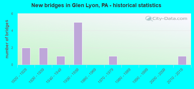
- New bridges - historical statistics
- 21920-1929
- 21930-1939
- 11940-1949
- 51950-1959
- 11970-1979
- 12010-2019

- Reconstructed bridges - Historical Statistics
- 21970-1979
- 21980-1989
- 21990-1999
- 22000-2009


- Bridge Condition - Deck
- 10.0%Excellent
- 30.0%Good
- 30.0%Satisfactory
- 30.0%Fair

- Bridge Condition - Superstructure
- 8.3%Excellent
- 16.7%Satisfactory
- 33.3%Fair
- 41.7%Poor

- Bridge Condition - Substructure
- 8.3%Good
- 50.0%Satisfactory
- 33.3%Fair
- 8.3%Poor

- Bridge Condition - Channel
- 12.5%Good
- 12.5%Satisfactory
- 25.0%Fair
- 50.0%Poor
Find on map >> Show street view
Structure Number: 6764, Location: BENSALEM TWP. 42C12 (Lat: 40.093578, Lng: -74.913647), Route carried "on" structure: US 13, Year Built: 1977, Status: Open, Structure Length: 8.41m (27.59ft), Average Daily Traffic: 16,340 (year 2022), Truck Traffic: 7%, Average Future Daily Traffic: 10,209 (year 2032), Design Load: HS 20, Features Intersected: NESHAMINY CREEK, Facility Carried by Structure: BRISTOL PIKE
Minimum Vertical Clearance: 30+ m (98+ ft), Kilometerpoint: 6.558, Lanes on structure: 2, Base Highway Network: Yes, Owner: State Highway Agency, Approaching Roadway Width: 15.8m (51.8ft), Skew: 21 degrees, Navigation Control: Yes ( Vertical Clearance: 999.7m (3,279.9ft), Horizontal Clearance: 9999.9m (32,808.1ft)), Material/Design: Prestressed concrete, Design/Construction: Box Beam or Girders - Multiple, Number Of Spans In Main Unit: 3, Length of Maximum Span: 27.4m (89.9ft), Curb or Sidewalk Widths: Left: 1.5m (4.9ft), Right: 1.5m (4.9ft), Curb-To-Curb Width: 16.2m (53.1ft), Out-to-Out Width: 19.7m (64.6ft)
Condition: Deck: Fair, Superstructure: Fair, Substructure: Satisfactory, Channel: Fair, Operating Rating: 98.0 metric tons, Method Used To Determine Operating Rating: Load Factor (LF), Inventory Rating: 31.8 metric tons, Method Used To Determine Inventory Rating: Load Factor (LF), Structural Evaluation: Somewhat better than minimum adequacy, Deck Geometry: Superior to present desirable criteria, Waterway Adequacy: Superior to present desirable criteria, Approach Roadway Alignment: Equal to present desirable criteria, Length Of Structure Improvement: 9.40m (30.84ft), Designated Inspection Frequency: Every 24 months, Underwater Inspection Frequency: Every 60 months, Inspection Date: October 2020, Underwater Inspection Date: December 2020, Deck Structure Type: Concrete Cast-file-Place, Wearing Surface/Protective System: Wearing Surface: Monolithic Concrete, Deck Protection: Galvanized Reinforcing
Find on map >> Show street view
Structure Number: 6771, Location: NORTH TULLYTOWN 38H11 (Lat: 40.171422, Lng: -74.812397), Route carried "on" structure: US 13, Year Built: 1955, Year Reconstructed: 2005, Status: Open, Structure Length: 4.82m (15.81ft), Average Daily Traffic: 17,323 (year 2021), Truck Traffic: 14%, Average Future Daily Traffic: 31,068 (year 2032), Design Load: HS 20, Features Intersected: PENN VALLEY ROAD
Minimum Vertical Clearance: 30+ m (98+ ft), Kilometerpoint: 20.431, Lanes on structure: 2, Lanes under structure: 2, Base Highway Network: Yes, Owner: State Highway Agency, Approaching Roadway Width: 21.9m (71.9ft), Skew: 31 degrees, Material/Design: Steel, Design/Construction: Stringer/Multi-beam, Number Of Spans In Main Unit: 3, Length of Maximum Span: 23.2m (76.1ft), Curb-To-Curb Width: 19.9m (65.3ft), Out-to-Out Width: 21.8m (71.5ft)
Condition: Deck: Good, Superstructure: Poor, Substructure: Satisfactory, Operating Rating: 62.6 metric tons, Method Used To Determine Operating Rating: Load Factor (LF), Inventory Rating: 37.2 metric tons, Method Used To Determine Inventory Rating: Load Factor (LF), Structural Evaluation: Meets minimum limits, Deck Geometry: Superior to present desirable criteria, Underclear: Equal to present minimum criteria, Approach Roadway Alignment: Equal to present desirable criteria, Length Of Structure Improvement: 5.70m (18.70ft), Designated Inspection Frequency: Every 24 months, Inspection Date: June 2020, Bridge Improvement Cost: $79,000, Roadway Improvement Cost: $232,000, Total Project Cost: $1,063,000, Deck Structure Type: Concrete Cast-file-Place, Wearing Surface/Protective System: Wearing Surface: Monolithic Concrete, Membrane: Other, Deck Protection: Epoxy Coated Reinforcing
Find on map >> Show street view
Structure Number: 6772, Location: .4MI.S.TYBURN RD. 38H10 (Lat: 40.177167, Lng: -74.812000), Route carried "on" structure: US 13, Year Built: 1955, Year Reconstructed: 2004, Status: Open, Structure Length: 1.22m (4.00ft), Average Daily Traffic: 17,323 (year 2021), Truck Traffic: 14%, Average Future Daily Traffic: 31,068 (year 2032), Design Load: HS 20, Features Intersected: BRANCH ROCK RUN
Minimum Vertical Clearance: 30+ m (98+ ft), Kilometerpoint: 21.078, Lanes on structure: 2, Base Highway Network: Yes, Owner: State Highway Agency, Approaching Roadway Width: 19.8m (65.0ft), Skew: 31 degrees, Material/Design: Concrete, Design/Construction: Tee Beam, Number Of Spans In Main Unit: 1, Length of Maximum Span: 11.9m (39.0ft), Curb-To-Curb Width: 19.8m (65.0ft), Out-to-Out Width: 21.8m (71.5ft)
Condition: Deck: Satisfactory, Superstructure: Satisfactory, Substructure: Fair, Channel: Poor, Operating Rating: 77.1 metric tons, Method Used To Determine Operating Rating: Load Factor (LF), Inventory Rating: 46.3 metric tons, Method Used To Determine Inventory Rating: Load Factor (LF), Structural Evaluation: Somewhat better than minimum adequacy, Deck Geometry: Superior to present desirable criteria, Waterway Adequacy: Equal to present minimum criteria, Approach Roadway Alignment: Equal to present desirable criteria, Length Of Structure Improvement: 1.90m (6.23ft), Designated Inspection Frequency: Every 24 months, Inspection Date: May 2020, Bridge Improvement Cost: $21,000, Roadway Improvement Cost: $63,000, Total Project Cost: $287,000, Deck Structure Type: Concrete Cast-file-Place, Wearing Surface/Protective System: Wearing Surface: Monolithic Concrete
Find on map >> Show street view
Structure Number: 6773, Location: 2MI.S.MORRISVILL 38H09 (Lat: 40.181164, Lng: -74.809058), Route carried "on" structure: US 13, Year Built: 1954, Year Reconstructed: 2005, Status: Open, Structure Length: 4.51m (14.80ft), Average Daily Traffic: 17,323 (year 2021), Truck Traffic: 14%, Average Future Daily Traffic: 31,068 (year 2032), Design Load: HS 20, Features Intersected: TYBURN ROAD
Minimum Vertical Clearance: 30+ m (98+ ft), Kilometerpoint: 21.078, Lanes on structure: 2, Lanes under structure: 4, Base Highway Network: Yes, Owner: State Highway Agency, Approaching Roadway Width: 22.6m (74.1ft), Skew: 31 degrees, Material/Design: Steel, Design/Construction: Stringer/Multi-beam, Number Of Spans In Main Unit: 3, Length of Maximum Span: 22.9m (75.1ft), Curb-To-Curb Width: 21.8m (71.5ft), Out-to-Out Width: 23.6m (77.4ft)
Condition: Deck: Good, Superstructure: Poor, Substructure: Satisfactory, Operating Rating: 62.6 metric tons, Method Used To Determine Operating Rating: Load Factor (LF), Inventory Rating: 37.2 metric tons, Method Used To Determine Inventory Rating: Load Factor (LF), Structural Evaluation: Meets minimum limits, Deck Geometry: Superior to present desirable criteria, Underclear: High priority of corrective action, Approach Roadway Alignment: Better than present minimum criteria, Length Of Structure Improvement: 5.50m (18.04ft), Designated Inspection Frequency: Every 24 months, Inspection Date: Febuary 2021, Bridge Improvement Cost: $149,000, Roadway Improvement Cost: $439,000, Total Project Cost: $2,012,000, Deck Structure Type: Concrete Cast-file-Place, Wearing Surface/Protective System: Wearing Surface: Monolithic Concrete, Deck Protection: Epoxy Coated Reinforcing
Find on map >> Show street view
Structure Number: 6774, Location: 1MI.S.MORRISVILL 38J07 (Lat: 40.194372, Lng: -74.801458), Route carried "on" structure: US 13, Year Built: 1954, Year Reconstructed: 2003, Status: Open, Structure Length: 19.14m (62.80ft), Average Daily Traffic: 22,807 (year 2022), Truck Traffic: 11%, Average Future Daily Traffic: 29,772 (year 2032), Design Load: HS 20, Features Intersected: NEWBOLD ROAD & Conrail
Minimum Vertical Clearance: 30+ m (98+ ft), Kilometerpoint: 23.194, Lanes on structure: 2, Lanes under structure: 2, Base Highway Network: Yes, Owner: State Highway Agency, Approaching Roadway Width: 21.9m (71.9ft), Skew: 30 degrees, Material/Design: Steel continuous, Design/Construction: Stringer/Multi-beam, Number Of Spans In Main Unit: 4, Number Of Approach Spans: 2, Length of Maximum Span: 38.1m (125.0ft), Curb-To-Curb Width: 17.7m (58.1ft), Out-to-Out Width: 20.3m (66.6ft)
Condition: Deck: Fair, Superstructure: Fair, Substructure: Satisfactory, Operating Rating: 55.3 metric tons, Method Used To Determine Operating Rating: Load Factor (LF), Inventory Rating: 33.6 metric tons, Method Used To Determine Inventory Rating: Load Factor (LF), Structural Evaluation: Somewhat better than minimum adequacy, Deck Geometry: Superior to present desirable criteria, Underclear: High priority of corrective action, Approach Roadway Alignment: Better than present minimum criteria, Length Of Structure Improvement: 19.80m (64.96ft), Designated Inspection Frequency: Every 24 months, Inspection Date: July 2020, Bridge Improvement Cost: $67,000, Roadway Improvement Cost: $197,000, Total Project Cost: $905,000, Deck Structure Type: Concrete Cast-file-Place, Wearing Surface/Protective System: Wearing Surface: Monolithic Concrete, Membrane: Other, Deck Protection: Epoxy Coated Reinforcing
Find on map >> Show street view
Structure Number: 6776, Location: 1MI.W.MORRISVILLE 38J06 (Lat: 40.196625, Lng: -74.801983), Route carried "on" structure: US 13, Year Built: 1954, Year Reconstructed: 1985, Status: Open, Structure Length: 5.55m (18.21ft), Average Daily Traffic: 22,807 (year 2022), Truck Traffic: 11%, Average Future Daily Traffic: 29,772 (year 2032), Design Load: HS 20, Features Intersected: US 1
Minimum Vertical Clearance: 30+ m (98+ ft), Kilometerpoint: 23.194, Lanes on structure: 2, Lanes under structure: 6, Base Highway Network: Yes, Owner: State Highway Agency, Approaching Roadway Width: 25.0m (82.0ft), Skew: 30 degrees, Material/Design: Steel, Design/Construction: Stringer/Multi-beam, Number Of Spans In Main Unit: 1, Number Of Approach Spans: 2, Length of Maximum Span: 25.6m (84.0ft), Curb or Sidewalk Widths: Left: 0.2m (0.7ft), Right: 0.2m (0.7ft), Curb-To-Curb Width: 24.0m (78.7ft), Out-to-Out Width: 26.2m (86.0ft)
Condition: Deck: Good, Superstructure: Satisfactory, Substructure: Fair, Operating Rating: 65.3 metric tons, Method Used To Determine Operating Rating: Load Factor (LF), Inventory Rating: 39.0 metric tons, Method Used To Determine Inventory Rating: Load Factor (LF), Structural Evaluation: Somewhat better than minimum adequacy, Deck Geometry: Superior to present desirable criteria, Underclear: High priority of corrective action, Approach Roadway Alignment: Equal to present desirable criteria, Length Of Structure Improvement: 6.40m (21.00ft), Designated Inspection Frequency: Every 24 months, Inspection Date: July 2020, Bridge Improvement Cost: $19,000, Roadway Improvement Cost: $55,000, Total Project Cost: $253,000, Deck Structure Type: Concrete Cast-file-Place, Wearing Surface/Protective System: Wearing Surface: Latex Concrete
Find on map >> Show street view
Structure Number: 236, Location: HUNLOCK TWP JCT SR 4016 (Lat: 41.205547, Lng: -76.066253), Route carried "on" structure: US 11, Year Built: 1940, Status: Open, Structure Length: 1.46m (4.79ft), Average Daily Traffic: 6,654 (year 2022), Truck Traffic: 7%, Average Future Daily Traffic: 10,663 (year 2032), Design Load: HS 20, Features Intersected: HUNLOCK CREEK
Minimum Vertical Clearance: 30+ m (98+ ft), Kilometerpoint: 25.679, Lanes on structure: 3, Base Highway Network: Yes, Owner: State Highway Agency, Approaching Roadway Width: 13.4m (44.0ft), Skew: 23 degrees, Material/Design: Concrete, Design/Construction: Tee Beam, Number Of Spans In Main Unit: 1, Length of Maximum Span: 14.0m (45.9ft), Curb-To-Curb Width: 18.1m (59.4ft), Out-to-Out Width: 21.3m (69.9ft)
Condition: Superstructure: Poor, Substructure: Satisfactory, Channel: Poor, Operating Rating: 51.7 metric tons, Method Used To Determine Operating Rating: Load Factor (LF), Inventory Rating: 30.8 metric tons, Method Used To Determine Inventory Rating: Load Factor (LF), Structural Evaluation: Meets minimum limits, Deck Geometry: Superior to present desirable criteria, Waterway Adequacy: Superior to present desirable criteria, Approach Roadway Alignment: Equal to present desirable criteria, Length Of Structure Improvement: 1.50m (4.92ft), Designated Inspection Frequency: Every 24 months, Inspection Date: January 2021, Bridge Improvement Cost: $17,000, Roadway Improvement Cost: $100,000, Total Project Cost: $230,000
Find on map >> Show street view
Structure Number: 24271, Location: HUNLOCK TWP 223' W SR4016 (Lat: 41.208542, Lng: -76.085867), Route carried "on" structure: State highway , Year Built: 1938, Status: Open, Structure Length: 1.04m (3.41ft), Average Daily Traffic: 366 (year 2021), Truck Traffic: 5%, Average Future Daily Traffic: 417 (year 2032), Features Intersected: HUNLOCK CREEK, Facility Carried by Structure: SR 4005 CRAGLE RD
Minimum Vertical Clearance: 30+ m (98+ ft), Kilometerpoint: 0.000, Lanes on structure: 2, Owner: State Highway Agency, Approaching Roadway Width: 7.3m (24.0ft), Material/Design: Masonry, Design/Construction: Arch - Deck, Number Of Spans In Main Unit: 2, Length of Maximum Span: 4.0m (13.1ft), Curb-To-Curb Width: 8.5m (27.9ft), Out-to-Out Width: 9.9m (32.5ft)
Condition: Superstructure: Fair, Substructure: Fair, Channel: Satisfactory, Operating Rating: 49.0 metric tons, Method Used To Determine Operating Rating: Field evaluation and documented engineering judgment, Inventory Rating: 32.7 metric tons, Method Used To Determine Inventory Rating: Field evaluation and documented engineering judgment, Structural Evaluation: Somewhat better than minimum adequacy, Deck Geometry: Equal to present minimum criteria, Waterway Adequacy: Equal to present minimum criteria, Approach Roadway Alignment: Equal to present desirable criteria, Length Of Structure Improvement: 1.70m (5.58ft), Designated Inspection Frequency: Every 24 months, Inspection Date: March 2021, Bridge Improvement Cost: $17,000, Roadway Improvement Cost: $49,000, Total Project Cost: $226,000
Find on map >> Show street view
Structure Number: 24319, Location: HUNLOCK TWP @ JCT SR 4003 (Lat: 41.215814, Lng: -76.091033), Route carried "on" structure: State highway , Year Built: 1925, Year Reconstructed: 1983, Status: Open, Structure Length: 1.77m (5.81ft), Average Daily Traffic: 3,087 (year 2022), Truck Traffic: 4%, Average Future Daily Traffic: 4,067 (year 2032), Design Load: H 20, Features Intersected: HUNLOCK CREEK, Facility Carried by Structure: SR 4016
Minimum Vertical Clearance: 30+ m (98+ ft), Kilometerpoint: 16.449, Lanes on structure: 2, Owner: State Highway Agency, Approaching Roadway Width: 7.3m (24.0ft), Skew: 3 degrees, Material/Design: Concrete, Design/Construction: Tee Beam, Number Of Spans In Main Unit: 2, Length of Maximum Span: 8.2m (26.9ft), Curb or Sidewalk Widths: Left: 0.2m (0.7ft), Right: 0.2m (0.7ft), Curb-To-Curb Width: 8.5m (27.9ft), Out-to-Out Width: 9.6m (31.5ft)
Condition: Deck: Satisfactory, Superstructure: Poor, Substructure: Poor, Channel: Poor, Operating Rating: 41.7 metric tons, Method Used To Determine Operating Rating: Load Factor (LF), Inventory Rating: 25.4 metric tons, Method Used To Determine Inventory Rating: Load Factor (LF), Structural Evaluation: Meets minimum limits, Deck Geometry: Meets minimum limits, Waterway Adequacy: Equal to present minimum criteria, Approach Roadway Alignment: Better than present minimum criteria, Length Of Structure Improvement: 1.80m (5.91ft), Designated Inspection Frequency: Every 24 months, Inspection Date: January 2021, Bridge Improvement Cost: $41,000, Roadway Improvement Cost: $217,000, Total Project Cost: $551,000, Deck Structure Type: Concrete Cast-file-Place, Wearing Surface/Protective System: Wearing Surface: Bituminous
Find on map >> Show street view
Structure Number: 2432, Location: HUNLOCK TWP .3M W SR 4001 (Lat: 41.209175, Lng: -76.078158), Route carried "on" structure: State highway , Year Built: 1925, Year Reconstructed: 1983, Status: Open, Structure Length: 2.01m (6.59ft), Average Daily Traffic: 4,017 (year 2022), Truck Traffic: 2%, Average Future Daily Traffic: 6,207 (year 2033), Design Load: H 20, Features Intersected: HUNLOCK CREEK, Facility Carried by Structure: SR 4016
Minimum Vertical Clearance: 30+ m (98+ ft), Kilometerpoint: 18.720, Lanes on structure: 2, Owner: State Highway Agency, Approaching Roadway Width: 8.5m (27.9ft), Skew: 2 degrees, Material/Design: Concrete, Design/Construction: Tee Beam, Number Of Spans In Main Unit: 2, Length of Maximum Span: 9.4m (30.8ft), Curb or Sidewalk Widths: Left: 0.2m (0.7ft), Right: 0.2m (0.7ft), Curb-To-Curb Width: 8.5m (27.9ft), Out-to-Out Width: 9.6m (31.5ft)
Condition: Deck: Satisfactory, Superstructure: Fair, Substructure: Satisfactory, Channel: Fair, Operating Rating: 43.5 metric tons, Method Used To Determine Operating Rating: Load Factor (LF), Inventory Rating: 25.4 metric tons, Method Used To Determine Inventory Rating: Load Factor (LF), Structural Evaluation: Somewhat better than minimum adequacy, Deck Geometry: Meets minimum limits, Waterway Adequacy: Equal to present minimum criteria, Approach Roadway Alignment: Better than present minimum criteria, Length Of Structure Improvement: 2.70m (8.86ft), Designated Inspection Frequency: Every 24 months, Inspection Date: January 2021, Bridge Improvement Cost: $16,000, Roadway Improvement Cost: $100,000, Total Project Cost: $214,000, Deck Structure Type: Concrete Cast-file-Place, Wearing Surface/Protective System: Wearing Surface: Bituminous
Find on map >> Show street view
Structure Number: 24408, Location: AT SR 11 INTERSECTION (Lat: 41.189397, Lng: -76.087900), Route carried "on" structure: ServiceOther road , Year Built: 1930, Year Reconstructed: 1991, Status: Posted for load, Structure Length: 36.73m (120.51ft), Average Daily Traffic: 250 (year 2009), Truck Traffic: 5%, Average Future Daily Traffic: 300 (year 2029), Features Intersected: SUSQUEHANNA RIVER, Facility Carried by Structure: RETREAT ACCESS RD
Minimum Vertical Clearance: 5.11m (16.77ft), Kilometerpoint: 0.000, Lanes on structure: 2, Owner: State Agenciy, Approaching Roadway Width: 6.1m (20.0ft), Material/Design: Steel, Design/Construction: Truss - Thru, Number Of Spans In Main Unit: 5, Number Of Approach Spans: 2, Length of Maximum Span: 66.1m (216.9ft), Curb or Sidewalk Widths: Left: 0.2m (0.7ft), Right: 2.6m (8.5ft), Curb-To-Curb Width: 5.0m (16.4ft), Out-to-Out Width: 6.1m (20.0ft)
Condition: Deck: Fair, Superstructure: Poor, Substructure: Fair, Channel: Poor, Operating Rating: 37.2 metric tons, Method Used To Determine Operating Rating: Load Factor (LF), Inventory Rating: 22.7 metric tons, Method Used To Determine Inventory Rating: Load Factor (LF), Structural Evaluation: Meets minimum limits, Deck Geometry: High priority of replacement, Waterway Adequacy: Equal to present minimum criteria, Approach Roadway Alignment: Somewhat better than minimum adequacy, Bridge Posting: Required (Relationship of Operating Rating to Maximum Legal Load: 0.1 - 9.9% below), Length Of Structure Improvement: 36.70m (120.41ft), Designated Inspection Frequency: Every 24 months, Critical Feature Inspection Frequency: Every 12 months, Underwater Inspection Frequency: Every 60 months, Other Special Inspection Frequency: Every 6 months, Inspection Date: March 2021, Critical Feature Inspection Date: March 2021, Underwater Inspection Date: October 2017, Other Special Inspection Date: March 2021, Bridge Improvement Cost: $28,000, Roadway Improvement Cost: $245,000, Total Project Cost: $999,000, Deck Structure Type: Open Grating
Find on map >> Show street view
Structure Number: 47023, Location: HUNLOCK TWP 300'W SR 4001 (Lat: 41.210317, Lng: -76.073533), Route carried "on" structure: State highway , Year Built: 2011, Status: Open, Structure Length: 2.13m (6.99ft), Average Daily Traffic: 4,017 (year 2022), Truck Traffic: 2%, Average Future Daily Traffic: 6,207 (year 2032), Design Load: HL 93, Features Intersected: HUNLOCK CREEK, Facility Carried by Structure: SR 4016
Minimum Vertical Clearance: 30+ m (98+ ft), Kilometerpoint: 18.720, Lanes on structure: 2, Owner: State Highway Agency, Approaching Roadway Width: 7.3m (24.0ft), Skew: 3 degrees, Material/Design: Prestressed concrete, Design/Construction: Box Beam or Girders - Multiple, Number Of Spans In Main Unit: 1, Length of Maximum Span: 20.7m (67.9ft), Curb-To-Curb Width: 9.1m (29.9ft), Out-to-Out Width: 10.1m (33.1ft)
Condition: Deck: Excellent, Superstructure: Excellent, Substructure: Good, Channel: Good, Operating Rating: 62.9 metric tons, Method Used To Determine Operating Rating: Assigned ratings based on Load and Resistance Factor Design (LRFD) reported by rating factor (RF) using HL93 loadings, Inventory Rating: 35.0 metric tons, Method Used To Determine Inventory Rating: Assigned ratings based on Load and Resistance Factor Design (LRFD) reported by rating factor (RF) using HL93 loadings, Structural Evaluation: Better than present minimum criteria, Deck Geometry: Meets minimum limits, Waterway Adequacy: Equal to present minimum criteria, Approach Roadway Alignment: Better than present minimum criteria, Designated Inspection Frequency: Every 48 months, Inspection Date: Febuary 2019, Deck Structure Type: Concrete Cast-file-Place, Wearing Surface/Protective System: Wearing Surface: Epoxy Overlay, Deck Protection: Epoxy Coated Reinforcing