Bridge Statistics for Glenarden, Maryland (MD)
Condition, Traffic, Stress, Structural Evaluation, Project Costs
- National Bridge Inventory (NBI) Statistics
- 13Number of bridges
- 223ft / 68.0mTotal length
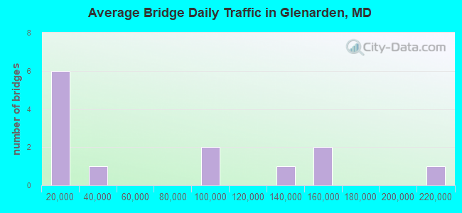
- 900,150Total average daily traffic
- 68,165Total average daily truck traffic
- National Bridge Inventory (NBI) Registered Bridges for Glenarden
- No street view available for this location
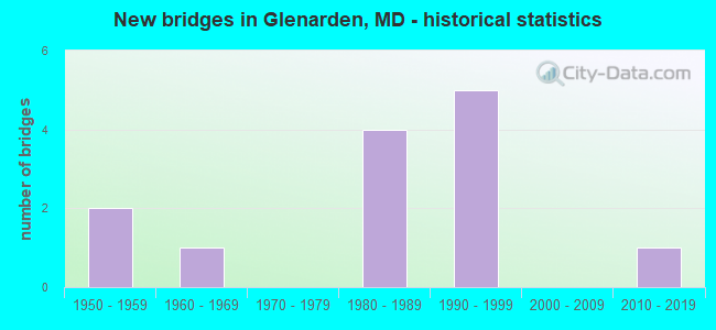
- New bridges - historical statistics
- 21950-1959
- 11960-1969
- 41980-1989
- 51990-1999
- 12010-2019

- Bridge Condition - Superstructure
- 66.7%Good
- 33.3%Satisfactory
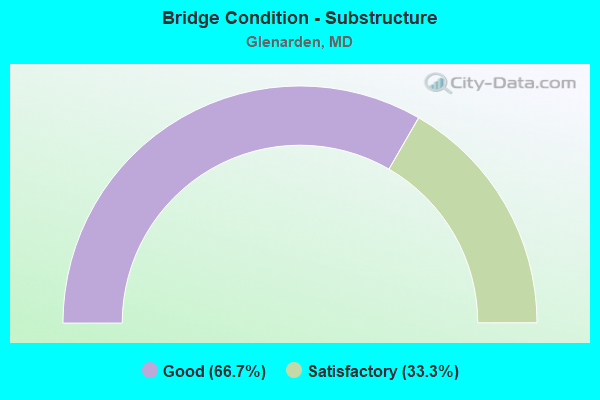
- Bridge Condition - Substructure
- 66.7%Good
- 33.3%Satisfactory
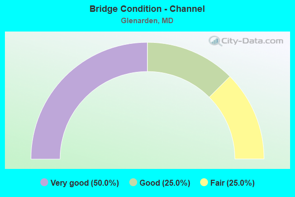
- Bridge Condition - Channel
- 50.0%Very good
- 25.0%Good
- 25.0%Fair
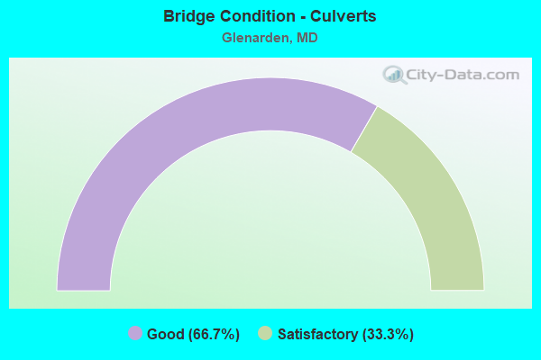
- Bridge Condition - Culverts
- 66.7%Good
- 33.3%Satisfactory
Find on map >> Show street view
Structure Number: 10000016009302, Location: 0.01 MI. W. OF US 50PA (Lat: 38.945003, Lng: -76.872667), Route carried "on" structure: Ramp US 50PA, Year Built: 1958, Status: Open, Structure Length: 4.24m (13.91ft), Average Daily Traffic: 1,020 (year 1994), Truck Traffic: 5%, Average Future Daily Traffic: 1,203 (year 2012), Design Load: HS 20, Features Intersected: BEAVERDAM CREEK
Minimum Vertical Clearance: 30+ m (98+ ft), Kilometerpoint: 0.016, Lanes on structure: 1, Base Highway Network: Yes, Owner: State Highway Agency, Approaching Roadway Width: 7.3m (24.0ft), Skew: 4 degrees, Material/Design: Concrete, Design/Construction: Culvert, Length of Maximum Span: 6.1m (20.0ft)
Condition: Channel: Fair, Culverts: Satisfactory, Operating Rating: 32.7 metric tons, Method Used To Determine Operating Rating: Field evaluation and documented engineering judgment, Inventory Rating: 32.7 metric tons, Method Used To Determine Inventory Rating: Field evaluation and documented engineering judgment, Structural Evaluation: Equal to present minimum criteria, Waterway Adequacy: Better than present minimum criteria, Approach Roadway Alignment: Equal to present desirable criteria, Designated Inspection Frequency: Every 24 months, Inspection Date: April 2021
Find on map >> Show street view
Structure Number: 10000016011301, Location: 0.52 MILE WEST OF IS 95 (Lat: 38.944147, Lng: -76.873369), Route carried "on" structure: US 50, Year Built: 1961, Year Reconstructed: 1988, Status: Open, Structure Length: 5.43m (17.81ft), Average Daily Traffic: 91,392 (year 2009), Truck Traffic: 8%, Average Future Daily Traffic: 128,366 (year 2026), Design Load: HS 20, Features Intersected: US 50PA
Minimum Vertical Clearance: 30+ m (98+ ft), Kilometerpoint: 7.273, Lanes on structure: 6, Lanes under structure: 2, Base Highway Network: Yes, Owner: State Highway Agency, Approaching Roadway Width: 37.2m (122.0ft), Skew: 20 degrees, Material/Design: Steel, Design/Construction: Stringer/Multi-beam, Number Of Spans In Main Unit: 4, Length of Maximum Span: 14.6m (47.9ft), Curb-To-Curb Width: 37.0m (121.4ft), Out-to-Out Width: 39.0m (128.0ft)
Condition: Deck: Good, Superstructure: Satisfactory, Substructure: Satisfactory, Channel: Good, Operating Rating: 76.6 metric tons, Method Used To Determine Operating Rating: Load Factor (LF), Inventory Rating: 45.8 metric tons, Method Used To Determine Inventory Rating: Load Factor (LF), Structural Evaluation: Equal to present minimum criteria, Deck Geometry: Superior to present desirable criteria, Underclear: Somewhat better than minimum adequacy, Approach Roadway Alignment: Equal to present desirable criteria, Designated Inspection Frequency: Every 24 months, Inspection Date: August 2020, Deck Structure Type: Concrete Cast-file-Place, Wearing Surface/Protective System: Wearing Surface: Monolithic Concrete, Deck Protection: Epoxy Coated Reinforcing
Find on map >> Show street view
Structure Number: 10000016018402, Location: 1 MI E OF JCT IS 95 (Lat: 38.946875, Lng: -76.839233), Route carried "on" structure: Interstate 595, Year Built: 1955, Year Reconstructed: 1989, Status: Open, Structure Length: 0.67m (2.20ft), Average Daily Traffic: 127,686 (year 2006), Truck Traffic: 8%, Average Future Daily Traffic: 137,901 (year 2026), Design Load: HS 20+Mod, Features Intersected: BALD HILL BRANCH
Minimum Vertical Clearance: 30+ m (98+ ft), Kilometerpoint: 2.076, Lanes on structure: 10, Base Highway Network: Yes, Owner: State Highway Agency, Approaching Roadway Width: 58.8m (192.9ft), Skew: 6 degrees, Material/Design: Concrete, Design/Construction: Culvert, Length of Maximum Span: 6.7m (22.0ft)
Condition: Channel: Very good, Culverts: Good, Operating Rating: 83.0 metric tons, Method Used To Determine Operating Rating: Load Factor (LF), Inventory Rating: 49.9 metric tons, Method Used To Determine Inventory Rating: Load Factor (LF), Structural Evaluation: Better than present minimum criteria, Waterway Adequacy: Equal to present desirable criteria, Approach Roadway Alignment: Equal to present desirable criteria, Designated Inspection Frequency: Every 24 months, Underwater Inspection Frequency: Every 48 months, Inspection Date: December 2021, Underwater Inspection Date: July 2019
Find on map >> Show street view
Structure Number: 10000016022501, Location: JUNCTION OF IS 95,IS 595 (Lat: 38.944319, Lng: -76.858275), Route carried "on" structure: Ramp Interstate 595, Year Built: 1992, Status: Open, Structure Length: 46.06m (151.12ft), Average Daily Traffic: 11,181 (year 2019), Truck Traffic: 8%, Average Future Daily Traffic: 13,643 (year 2039), Design Load: HS 20, Features Intersected: IS 95, IS 595, RAMPS A&D
Minimum Vertical Clearance: 30+ m (98+ ft), Kilometerpoint: 0.676, Lanes on structure: 1, Lanes under structure: 17, Base Highway Network: Yes (Inventory Route: 59, Subroute: 3), Owner: State Highway Agency, Approaching Roadway Width: 12.5m (41.0ft), Skew: 1 degrees, Material/Design: Steel continuous, Design/Construction: Stringer/Multi-beam, Number Of Spans In Main Unit: 6, Length of Maximum Span: 50.0m (164.0ft), Curb-To-Curb Width: 9.4m (30.8ft), Out-to-Out Width: 10.7m (35.1ft)
Condition: Deck: Good, Superstructure: Good, Substructure: Good, Operating Rating: 89.8 metric tons, Method Used To Determine Operating Rating: Load Factor (LF), Inventory Rating: 53.5 metric tons, Method Used To Determine Inventory Rating: Load Factor (LF), Structural Evaluation: Better than present minimum criteria, Deck Geometry: Superior to present desirable criteria, Underclear: Somewhat better than minimum adequacy, Approach Roadway Alignment: Equal to present desirable criteria, Designated Inspection Frequency: Every 24 months, Inspection Date: October 2020, Deck Structure Type: Concrete Cast-file-Place, Wearing Surface/Protective System: Wearing Surface: Integral Concrete, Deck Protection: Epoxy Coated Reinforcing
Find on map >> Show street view
Structure Number: 10000016024401, Location: 0.5 MI W OF IS 95 (Lat: 38.944017, Lng: -76.870897), Route carried "on" structure: County highway 2428, Year Built: 1987, Status: Open, Structure Length: 10.88m (35.70ft), Average Daily Traffic: 17,751 (year 2006), Truck Traffic: 5%, Average Future Daily Traffic: 20,467 (year 2026), Design Load: HS 20, Features Intersected: US 50 & RAMP 'H', Facility Carried by Structure: PENNSY DRIVE
Minimum Vertical Clearance: 30+ m (98+ ft), Kilometerpoint: 2.832, Lanes on structure: 2, Lanes under structure: 10, Owner: State Highway Agency, Approaching Roadway Width: 12.2m (40.0ft), Skew: 3 degrees, Material/Design: Steel continuous, Design/Construction: Stringer/Multi-beam, Number Of Spans In Main Unit: 2, Length of Maximum Span: 54.9m (180.1ft), Curb-To-Curb Width: 12.2m (40.0ft), Out-to-Out Width: 13.2m (43.3ft)
Condition: Deck: Good, Superstructure: Good, Substructure: Good, Inventory Rating: 66.7 metric tons, Method Used To Determine Inventory Rating: Load Factor (LF), Structural Evaluation: Better than present minimum criteria, Deck Geometry: Somewhat better than minimum adequacy, Underclear: Meets minimum limits, Approach Roadway Alignment: Equal to present desirable criteria, Designated Inspection Frequency: Every 24 months, Inspection Date: June 2021, Deck Structure Type: Concrete Cast-file-Place, Wearing Surface/Protective System: Wearing Surface: Monolithic Concrete, Deck Protection: Epoxy Coated Reinforcing
Find on map >> Show street view
Structure Number: 200000P-026602, Location: .2 MI N OF ST JOSEPHS DR (Lat: 38.920828, Lng: -76.843781), Route carried "on" structure: County highway 6403, Year Built: 2010, Status: Open, Structure Length: 0.76m (2.49ft), Average Daily Traffic: 9,000 (year 2014), Truck Traffic: 5%, Average Future Daily Traffic: 13,375 (year 2034), Design Load: HS 20, Features Intersected: UNNAMED STREAM, Facility Carried by Structure: RUBY LOCKHARDT BOU
Minimum Vertical Clearance: 30+ m (98+ ft), Kilometerpoint: 0.000, Lanes on structure: 4, Owner: County Highway Agency, Approaching Roadway Width: 20.1m (65.9ft), Skew: 3 degrees, Material/Design: Concrete, Design/Construction: Culvert, Length of Maximum Span: 3.0m (9.8ft), Curb or Sidewalk Widths: Left: 2.4m (7.9ft), Right: 2.4m (7.9ft)
Condition: Channel: Very good, Culverts: Good, Structural Evaluation: Better than present minimum criteria, Waterway Adequacy: Superior to present desirable criteria, Approach Roadway Alignment: Equal to present desirable criteria, Designated Inspection Frequency: Every 24 months, Inspection Date: July 2021
Find on map >> Show street view
Structure Number: 10000016022501, Location: 0.08 MILE SOUTH OF IS 595 (Lat: 38.944356, Lng: -76.858244), Route carried "under" structure: Interstate 95, Year Built: 1992, Structure Length: 0. m, Average Daily Traffic: 212,990 (year 2009), Truck Traffic: 8%, Features Intersected: IS 95
Minimum Vertical Clearance: 5.18m (16.99ft), Kilometerpoint: 29.702, Lanes on structure: 1, Lanes under structure: 8, Material/Design: Steel continuous, Design/Construction: Stringer/Multi-beam, Length of Maximum Span: 50.0m (164.0ft)
Find on map >> Show street view
Structure Number: 10000016022501, Location: 0.13 MILE EAST OF IS 95 (Lat: 38.944356, Lng: -76.858244), Route carried "under" structure: Interstate 595, Year Built: 1992, Structure Length: 0. m, Average Daily Traffic: 148,320 (year 2006), Truck Traffic: 8%, Features Intersected: IS 595
Minimum Vertical Clearance: 5.18m (16.99ft), Kilometerpoint: 0.676, Lanes on structure: 1, Lanes under structure: 6, Material/Design: Steel continuous, Design/Construction: Stringer/Multi-beam, Length of Maximum Span: 50.0m (164.0ft)
Find on map >> Show street view
Structure Number: 10000016022501, Location: 0.13 MILE EAST OF IS 95 (Lat: 38.944356, Lng: -76.858244), Route carried "under" structure: Ramp Interstate 95, Year Built: 1992, Structure Length: 0. m, Average Daily Traffic: 26,566 (year 2006), Truck Traffic: 8%, Features Intersected: IS 95 RAMP A(5)
Minimum Vertical Clearance: 5.49m (18.01ft), Kilometerpoint: 0.671, Lanes on structure: 1, Lanes under structure: 2, Material/Design: Steel continuous, Design/Construction: Stringer/Multi-beam, Length of Maximum Span: 50.0m (164.0ft)
Find on map >> Show street view
Structure Number: 10000016022501, Location: 0.13 MILE EAST OF IS 95 (Lat: 38.944356, Lng: -76.858244), Route carried "under" structure: Ramp Interstate 595, Year Built: 1992, Structure Length: 0. m, Average Daily Traffic: 153,970 (year 2009), Truck Traffic: 8%, Features Intersected: IS 95 RAMP D(7)
Minimum Vertical Clearance: 5.18m (16.99ft), Kilometerpoint: 0.676, Lanes on structure: 1, Lanes under structure: 1, Material/Design: Steel continuous, Design/Construction: Stringer/Multi-beam, Length of Maximum Span: 50.0m (164.0ft)
Find on map >> Show street view
Structure Number: 10000016024401, Location: 0.39 MILE WEST OF IS 595 (Lat: 38.944017, Lng: -76.870897), Route carried "under" structure: Ramp US 50, Year Built: 1987, Structure Length: 0. m, Average Daily Traffic: 4,584 (year 2004), Truck Traffic: 5%, Features Intersected: RAMP 'H', Facility Carried by Structure: PENNSY DRIVE
Minimum Vertical Clearance: 4.88m (16.01ft), Kilometerpoint: 7.482, Lanes on structure: 2, Lanes under structure: 2, Material/Design: Steel continuous, Design/Construction: Stringer/Multi-beam, Length of Maximum Span: 54.9m (180.1ft)
Find on map >> Show street view
Structure Number: 10000016024401, Location: 0.39 MILE WEST OF IS 595 (Lat: 38.944017, Lng: -76.870897), Route carried "under" structure: US 50, Year Built: 1987, Structure Length: 0. m, Average Daily Traffic: 91,392 (year 2009), Truck Traffic: 5%, Features Intersected: US 50, Facility Carried by Structure: PENNSY DRIVE
Minimum Vertical Clearance: 4.88m (16.01ft), Kilometerpoint: 7.482, Lanes on structure: 2, Lanes under structure: 6, Material/Design: Steel continuous, Design/Construction: Stringer/Multi-beam, Length of Maximum Span: 54.9m (180.1ft)
Find on map >> Show street view
Structure Number: 10000016024401, Location: 0.39 MILE WEST OF IS 595 (Lat: 38.944017, Lng: -76.870897), Route carried "under" structure: Ramp US 50, Year Built: 1987, Structure Length: 0. m, Average Daily Traffic: 4,298 (year 2004), Truck Traffic: 5%, Features Intersected: WB RAMP, Facility Carried by Structure: PENNSY DRIVE
Minimum Vertical Clearance: 4.88m (16.01ft), Kilometerpoint: 7.482, Lanes on structure: 2, Lanes under structure: 2, Material/Design: Steel continuous, Design/Construction: Stringer/Multi-beam, Length of Maximum Span: 54.9m (180.1ft)