Bridge Statistics for Glenvar Heights, Florida (FL)
Condition, Traffic, Stress, Structural Evaluation, Project Costs
- National Bridge Inventory (NBI) Statistics
- 10Number of bridges
- 246ft / 75.1mTotal length
- 416,421Total average daily traffic
- 29,652Total average daily truck traffic
- National Bridge Inventory (NBI) Registered Bridges for Glenvar Heights
- No street view available for this location
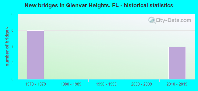
- New bridges - historical statistics
- 61970-1979
- 42010-2019
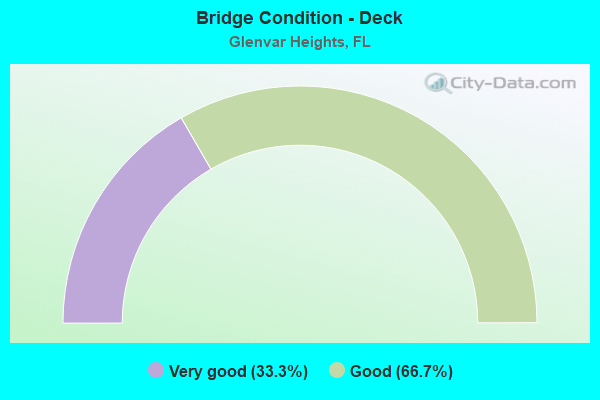
- Bridge Condition - Deck
- 33.3%Very good
- 66.7%Good
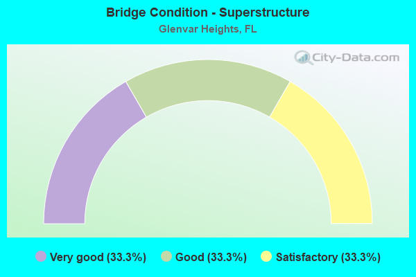
- Bridge Condition - Superstructure
- 33.3%Very good
- 33.3%Good
- 33.3%Satisfactory
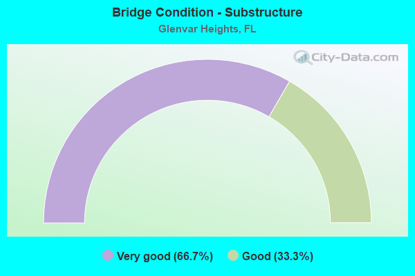
- Bridge Condition - Substructure
- 66.7%Very good
- 33.3%Good
Find on map >> Show street view
Structure Number: 870525, Location: 1.4 mile North of SR 94 (Lat: 25.706694, Lng: -80.334242), Route carried "on" structure: State highway 874, Year Built: 1975, Status: Open, Structure Length: 26.56m (87.14ft), Average Daily Traffic: 49,750 (year 2020), Truck Traffic: 7%, Average Future Daily Traffic: 86,316 (year 2042), Design Load: HS 20, Features Intersected: SR 973 (SW 87th Ave)
Minimum Vertical Clearance: 30+ m (98+ ft), Kilometerpoint: 8.660, Lanes on structure: 3, Lanes under structure: 4, Toll: On toll road, Owner: State Toll Authority, Approaching Roadway Width: 18.6m (61.0ft), Skew: 9 degrees, Material/Design: Prestressed concrete, Design/Construction: Stringer/Multi-beam, Number Of Spans In Main Unit: 9, Length of Maximum Span: 33.8m (110.9ft), Curb-To-Curb Width: 12.7m (41.7ft), Out-to-Out Width: 13.7m (44.9ft)
Condition: Deck: Good, Superstructure: Good, Substructure: Good, Operating Rating: 44.2 metric tons, Method Used To Determine Operating Rating: Load Factor (LF), Inventory Rating: 32.7 metric tons, Method Used To Determine Inventory Rating: Load Factor (LF), Structural Evaluation: Better than present minimum criteria, Deck Geometry: Meets minimum limits, Underclear: Somewhat better than minimum adequacy, Approach Roadway Alignment: Equal to present desirable criteria, Designated Inspection Frequency: Every 24 months, Inspection Date: September 2020, Deck Structure Type: Concrete Cast-file-Place
Find on map >> Show street view
Structure Number: 870526, Location: 0.5 mile South of SR 826 (Lat: 25.717417, Lng: -80.323958), Route carried "on" structure: State highway 874, Year Built: 1974, Year Reconstructed: 2013, Status: Open, Structure Length: 8.38m (27.49ft), Average Daily Traffic: 99,500 (year 2020), Truck Traffic: 7%, Average Future Daily Traffic: 172,632 (year 2042), Design Load: HS 20, Features Intersected: SW 56th St (Miller Rd)
Minimum Vertical Clearance: 30+ m (98+ ft), Kilometerpoint: 10.210, Lanes on structure: 6, Lanes under structure: 4, Toll: On toll road, Owner: State Toll Authority, Approaching Roadway Width: 34.1m (111.9ft), Skew: 34 degrees, Material/Design: Prestressed concrete, Design/Construction: Stringer/Multi-beam, Number Of Spans In Main Unit: 4, Length of Maximum Span: 25.6m (84.0ft), Curb-To-Curb Width: 34.1m (111.9ft), Out-to-Out Width: 35.7m (117.1ft)
Condition: Deck: Good, Superstructure: Very good, Substructure: Very good, Operating Rating: 39.5 metric tons, Method Used To Determine Operating Rating: Load and Resistance Factor (LRFR), Inventory Rating: 30.4 metric tons, Method Used To Determine Inventory Rating: Load and Resistance Factor (LRFR), Structural Evaluation: Better than present minimum criteria, Deck Geometry: Superior to present desirable criteria, Underclear: Better than present minimum criteria, Approach Roadway Alignment: Better than present minimum criteria, Designated Inspection Frequency: Every 24 months, Inspection Date: January 2022, Deck Structure Type: Concrete Cast-file-Place
Find on map >> Show street view
Structure Number: 870542, Location: KILLIAN PKWY INTERCHANGE (Lat: 25.669972, Lng: -80.367583), Route carried "on" structure: Ramp State highway 874, Year Built: 1973, Status: Open, Structure Length: 9.22m (30.25ft), Average Daily Traffic: 4,100 (year 2020), Truck Traffic: 12%, Average Future Daily Traffic: 7,114 (year 2042), Design Load: HS 20, Features Intersected: SCL R/R
Minimum Vertical Clearance: 30+ m (98+ ft), Kilometerpoint: 0.274, Lanes on structure: 1, Base Highway Network: Yes, Toll: On toll road, Owner: State Toll Authority, Approaching Roadway Width: 6.4m (21.0ft), Skew: 9 degrees, Material/Design: Prestressed concrete, Design/Construction: Stringer/Multi-beam, Number Of Spans In Main Unit: 5, Length of Maximum Span: 25.1m (82.3ft), Curb-To-Curb Width: 6.4m (21.0ft), Out-to-Out Width: 7.7m (25.3ft)
Condition: Deck: Good, Superstructure: Good, Substructure: Good, Operating Rating: 53.0 metric tons, Method Used To Determine Operating Rating: Load and Resistance Factor (LRFR), Inventory Rating: 29.8 metric tons, Method Used To Determine Inventory Rating: Load and Resistance Factor (LRFR), Structural Evaluation: Better than present minimum criteria, Deck Geometry: Somewhat better than minimum adequacy, Underclear: Somewhat better than minimum adequacy, Approach Roadway Alignment: Better than present minimum criteria, Designated Inspection Frequency: Every 24 months, Inspection Date: August 2020, Deck Structure Type: Concrete Cast-file-Place, Wearing Surface/Protective System: Wearing Surface: Monolithic Concrete
Find on map >> Show street view
Structure Number: 870543, Location: Ramp to EB SR 990 (Lat: 25.670819, Lng: -80.366819), Route carried "on" structure: Ramp State highway 874, Year Built: 1973, Status: Open, Structure Length: 7.90m (25.92ft), Average Daily Traffic: 26,571 (year 2020), Truck Traffic: 5%, Average Future Daily Traffic: 32,857 (year 2042), Design Load: HL 93, Features Intersected: SCL R/R
Minimum Vertical Clearance: 30+ m (98+ ft), Kilometerpoint: 3.473, Lanes on structure: 1, Base Highway Network: Yes, Toll: On toll road, Owner: State Toll Authority, Approaching Roadway Width: 5.2m (17.1ft), Skew: 9 degrees, Material/Design: Prestressed concrete, Design/Construction: Stringer/Multi-beam, Number Of Spans In Main Unit: 5, Length of Maximum Span: 20.4m (66.9ft), Curb-To-Curb Width: 6.7m (22.0ft), Out-to-Out Width: 7.7m (25.3ft)
Condition: Deck: Very good, Superstructure: Very good, Substructure: Very good, Operating Rating: 49.5 metric tons, Method Used To Determine Operating Rating: Load and Resistance Factor (LRFR), Inventory Rating: 38.3 metric tons, Method Used To Determine Inventory Rating: Load and Resistance Factor (LRFR), Structural Evaluation: Equal to present desirable criteria, Deck Geometry: Equal to present minimum criteria, Underclear: Somewhat better than minimum adequacy, Approach Roadway Alignment: Somewhat better than minimum adequacy, Designated Inspection Frequency: Every 24 months, Inspection Date: August 2020, Deck Structure Type: Concrete Cast-file-Place, Wearing Surface/Protective System: Wearing Surface: Monolithic Concrete
Find on map >> Show street view
Structure Number: 871013, Location: 1 MILE S OF SR-976 (Lat: 25.717794, Lng: -80.318450), Route carried "on" structure: State highway 826, Year Built: 2011, Status: Open, Structure Length: 4.87m (15.98ft), Average Daily Traffic: 144,000 (year 2020), Truck Traffic: 6%, Average Future Daily Traffic: 249,840 (year 2042), Design Load: HL 93, Features Intersected: SW 56TH ST (MILLER DR)
Minimum Vertical Clearance: 30.18m (99.02ft), Kilometerpoint: 4.614, Lanes on structure: 7, Lanes under structure: 8, Base Highway Network: Yes, Owner: State Highway Agency, Approaching Roadway Width: 37.2m (122.0ft), Skew: 30 degrees, Material/Design: Prestressed concrete, Design/Construction: Stringer/Multi-beam, Number Of Spans In Main Unit: 1, Length of Maximum Span: 48.7m (159.8ft), Curb-To-Curb Width: 37.2m (122.0ft), Out-to-Out Width: 38.7m (127.0ft)
Condition: Deck: Very good, Superstructure: Satisfactory, Substructure: Very good, Operating Rating: 44.1 metric tons, Method Used To Determine Operating Rating: Load and Resistance Factor (LRFR), Inventory Rating: 39.8 metric tons, Method Used To Determine Inventory Rating: Load and Resistance Factor (LRFR), Structural Evaluation: Equal to present minimum criteria, Deck Geometry: Superior to present desirable criteria, Underclear: Better than present minimum criteria, Approach Roadway Alignment: Equal to present desirable criteria, Designated Inspection Frequency: Every 24 months, Inspection Date: April 2021, Deck Structure Type: Concrete Cast-file-Place
Find on map >> Show street view
Structure Number: 871014, Location: SW 56 ST TO SR-826 NB (Lat: 25.717775, Lng: -80.317942), Route carried "on" structure: State highway 826, Year Built: 2010, Status: Open, Structure Length: 18.20m (59.71ft), Average Daily Traffic: 5,500 (year 2020), Truck Traffic: 12%, Average Future Daily Traffic: 9,542 (year 2042), Design Load: HL 93, Features Intersected: SW 56TH ST (MILLER DR.)
Minimum Vertical Clearance: 30+ m (98+ ft), Kilometerpoint: 0.095, Lanes on structure: 1, Lanes under structure: 6, Base Highway Network: Yes, Owner: State Highway Agency, Approaching Roadway Width: 8.1m (26.6ft), Material/Design: Prestressed concrete, Design/Construction: Stringer/Multi-beam, Number Of Spans In Main Unit: 5, Length of Maximum Span: 47.9m (157.2ft), Curb-To-Curb Width: 8.1m (26.6ft), Out-to-Out Width: 9.1m (29.9ft)
Condition: Deck: Good, Superstructure: Satisfactory, Substructure: Very good, Operating Rating: 37.9 metric tons, Method Used To Determine Operating Rating: Load and Resistance Factor (LRFR), Inventory Rating: 34.7 metric tons, Method Used To Determine Inventory Rating: Load and Resistance Factor (LRFR), Structural Evaluation: Equal to present minimum criteria, Deck Geometry: High priority of corrective action, Underclear: Somewhat better than minimum adequacy, Approach Roadway Alignment: Equal to present desirable criteria, Designated Inspection Frequency: Every 24 months, Inspection Date: March 2021, Deck Structure Type: Concrete Cast-file-Place
Find on map >> Show street view
Structure Number: 870525, Location: 1.4 mile North of SR 94 (Lat: 25.706694, Lng: -80.334242), Route carried "under" structure: State highway 973, Year Built: 1975, Structure Length: 0. m, Average Daily Traffic: 25,500 (year 2020), Truck Traffic: 4%, Features Intersected: SR 973 (SW 87th Ave), Facility Carried by Structure: SR 874 NB
Minimum Vertical Clearance: 8.53m (27.99ft), Kilometerpoint: 6.756, Lanes on structure: 3, Lanes under structure: 4, Material/Design: Prestressed concrete, Design/Construction: Stringer/Multi-beam, Length of Maximum Span: 33.8m (110.9ft)
Find on map >> Show street view
Structure Number: 870526, Location: 0.5 mile South of SR 826 (Lat: 25.717417, Lng: -80.323958), Route carried "under" structure: City street , Year Built: 1974, Structure Length: 0. m, Average Daily Traffic: 5,000 (year 2020), Truck Traffic: 5%, Features Intersected: SW 56th St (Miller Rd), Facility Carried by Structure: SR 874
Minimum Vertical Clearance: 4.95m (16.24ft), Kilometerpoint: 0.000, Lanes on structure: 6, Lanes under structure: 4, Material/Design: Prestressed concrete, Design/Construction: Stringer/Multi-beam, Length of Maximum Span: 25.6m (84.0ft)
Find on map >> Show street view
Structure Number: 871013, Location: 1 MILE S OF SR-976 (Lat: 25.717794, Lng: -80.318450), Route carried "under" structure: City street , Year Built: 2011, Structure Length: 0. m, Average Daily Traffic: 26,500 (year 2020), Truck Traffic: 11%, Features Intersected: SW 56TH ST (MILLER DR), Facility Carried by Structure: SR-826 NB/SB
Minimum Vertical Clearance: 5.03m (16.50ft), Kilometerpoint: 1.643, Lanes on structure: 7, Lanes under structure: 8, Material/Design: Prestressed concrete, Design/Construction: Stringer/Multi-beam, Length of Maximum Span: 48.7m (159.8ft)
Find on map >> Show street view
Structure Number: 871014, Location: SW 56 ST TO SR-826 NB (Lat: 25.717775, Lng: -80.317942), Route carried "under" structure: City street , Year Built: 2010, Structure Length: 0. m, Average Daily Traffic: 30,000 (year 2018), Truck Traffic: 13%, Features Intersected: SW 56TH ST (MILLER DR.), Facility Carried by Structure: SR-826 NB
Minimum Vertical Clearance: 5.16m (16.93ft), Kilometerpoint: 1.693, Lanes on structure: 1, Lanes under structure: 6, Material/Design: Prestressed concrete, Design/Construction: Stringer/Multi-beam, Length of Maximum Span: 47.9m (157.2ft)