Bridge Statistics for Golden Gate, Florida (FL)
Condition, Traffic, Stress, Structural Evaluation, Project Costs
- National Bridge Inventory (NBI) Statistics
- 29Number of bridges
- 295ft / 89.7mTotal length
- 350,561Total average daily traffic
- 26,676Total average daily truck traffic
- National Bridge Inventory (NBI) Registered Bridges for Golden Gate
- No street view available for this location
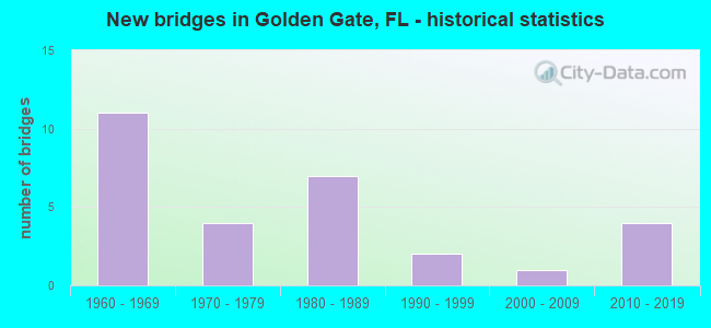
- New bridges - historical statistics
- 111960-1969
- 41970-1979
- 71980-1989
- 21990-1999
- 12000-2009
- 42010-2019
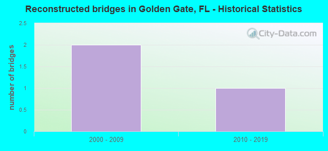
- Reconstructed bridges - Historical Statistics
- 22000-2009
- 12010-2019
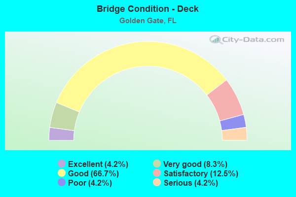
- Bridge Condition - Deck
- 4.2%Excellent
- 8.3%Very good
- 66.7%Good
- 12.5%Satisfactory
- 4.2%Poor
- 4.2%Serious
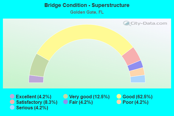
- Bridge Condition - Superstructure
- 4.2%Excellent
- 12.5%Very good
- 62.5%Good
- 8.3%Satisfactory
- 4.2%Fair
- 4.2%Poor
- 4.2%Serious
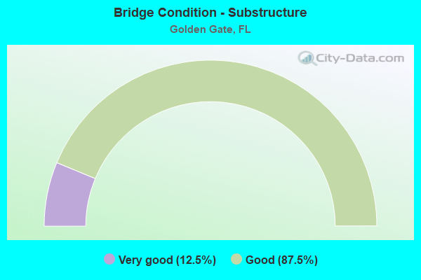
- Bridge Condition - Substructure
- 12.5%Very good
- 87.5%Good
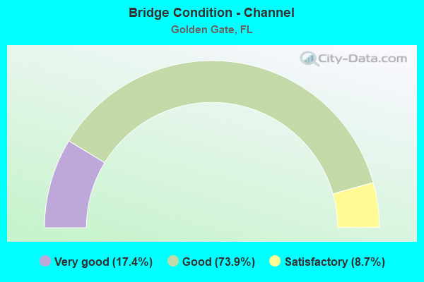
- Bridge Condition - Channel
- 17.4%Very good
- 73.9%Good
- 8.7%Satisfactory
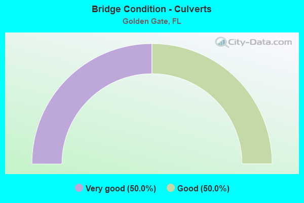
- Bridge Condition - Culverts
- 50.0%Very good
- 50.0%Good
Find on map >> Show street view
Structure Number: 30038, Location: 7.2 MI EAST OF I-75 (Lat: 26.275175, Lng: -81.625567), Route carried "on" structure: County highway 846, Year Built: 1966, Year Reconstructed: 2006, Status: Open, Structure Length: 0.67m (2.20ft), Average Daily Traffic: 21,523 (year 2021), Truck Traffic: 10%, Average Future Daily Traffic: 22,599 (year 2041), Design Load: HS 20, Features Intersected: DRAINAGE CANAL
Minimum Vertical Clearance: 30+ m (98+ ft), Kilometerpoint: 17.611, Lanes on structure: 6, Base Highway Network: Yes, Owner: County Highway Agency, Approaching Roadway Width: 26.3m (86.3ft), Skew: 10 degrees, Material/Design: Concrete, Design/Construction: Culvert, Number Of Spans In Main Unit: 2, Length of Maximum Span: 3.4m (11.2ft), Curb or Sidewalk Widths: Left: 0.0m, Right: 1.8m (5.9ft)
Condition: Channel: Good, Culverts: Good, Structural Evaluation: Better than present minimum criteria, Waterway Adequacy: Better than present minimum criteria, Approach Roadway Alignment: Equal to present desirable criteria, Designated Inspection Frequency: Every 24 months, Inspection Date: April 2021
Find on map >> Show street view
Structure Number: 30123, Location: 1.68MI W OF CR-951 (Lat: 26.176872, Lng: -81.711114), Route carried "on" structure: County highway 886, Year Built: 1971, Status: Open, Structure Length: 3.06m (10.04ft), Average Daily Traffic: 10,000 (year 2021), Truck Traffic: 5%, Average Future Daily Traffic: 12,500 (year 2041), Design Load: HS 20, Features Intersected: SANTA BARBARA CNL
Minimum Vertical Clearance: 30+ m (98+ ft), Kilometerpoint: 5.691, Lanes on structure: 4, Owner: County Highway Agency, Approaching Roadway Width: 14.4m (47.2ft), Skew: 30 degrees, Material/Design: Prestressed concrete, Design/Construction: Slab, Number Of Spans In Main Unit: 3, Length of Maximum Span: 10.1m (33.1ft), Curb or Sidewalk Widths: Left: 1.1m (3.6ft), Right: 1.1m (3.6ft), Curb-To-Curb Width: 15.1m (49.5ft), Out-to-Out Width: 18.0m (59.1ft)
Condition: Deck: Serious, Superstructure: Serious, Substructure: Good, Channel: Very good, Operating Rating: 35.3 metric tons, Method Used To Determine Operating Rating: Load and Resistance Factor (LRFR), Inventory Rating: 28.8 metric tons, Method Used To Determine Inventory Rating: Load and Resistance Factor (LRFR), Structural Evaluation: High priority of corrective action, Deck Geometry: High priority of corrective action, Waterway Adequacy: Better than present minimum criteria, Approach Roadway Alignment: Equal to present desirable criteria, Designated Inspection Frequency: Every 24 months, Underwater Inspection Frequency: Every 24 months, Other Special Inspection Frequency: Every 6 months, Inspection Date: March 2020, Underwater Inspection Date: Febuary 2020, Other Special Inspection Date: September 2021, Deck Structure Type: Concrete Precast Panels, Wearing Surface/Protective System: Wearing Surface: Bituminous
Find on map >> Show street view
Structure Number: 30195, Location: 1.1mi Wof Toll Plz MM93.2 (Lat: 26.160522, Lng: -81.686583), Route carried "on" structure: Interstate 75, Year Built: 1984, Status: Open, Structure Length: 6.28m (20.60ft), Average Daily Traffic: 13,202 (year 2021), Truck Traffic: 12%, Average Future Daily Traffic: 22,905 (year 2041), Design Load: HS 20+Mod, Features Intersected: SR-951
Minimum Vertical Clearance: 30+ m (98+ ft), Kilometerpoint: 81.130, Lanes on structure: 2, Lanes under structure: 8, Base Highway Network: Yes, Owner: State Highway Agency, Approaching Roadway Width: 11.6m (38.1ft), Skew: 3 degrees, Material/Design: Prestressed concrete, Design/Construction: Stringer/Multi-beam, Number Of Spans In Main Unit: 2, Length of Maximum Span: 31.4m (103.0ft), Curb-To-Curb Width: 12.2m (40.0ft), Out-to-Out Width: 13.1m (43.0ft)
Condition: Deck: Good, Superstructure: Good, Substructure: Good, Operating Rating: 60.4 metric tons, Method Used To Determine Operating Rating: Load Factor (LF), Inventory Rating: 33.3 metric tons, Method Used To Determine Inventory Rating: Load Factor (LF), Structural Evaluation: Better than present minimum criteria, Deck Geometry: Better than present minimum criteria, Underclear: High priority of corrective action, Approach Roadway Alignment: Equal to present desirable criteria, Designated Inspection Frequency: Every 24 months, Inspection Date: March 2021, Deck Structure Type: Concrete Cast-file-Place
Find on map >> Show street view
Structure Number: 30196, Location: 1.1mi W/O Toll Pl MM101.3 (Lat: 26.160194, Lng: -81.686611), Route carried "on" structure: Interstate 75, Year Built: 1984, Status: Open, Structure Length: 6.28m (20.60ft), Average Daily Traffic: 13,202 (year 2021), Truck Traffic: 12%, Average Future Daily Traffic: 22,905 (year 2041), Design Load: HS 20+Mod, Features Intersected: SR-951
Minimum Vertical Clearance: 30+ m (98+ ft), Kilometerpoint: 81.119, Lanes on structure: 2, Lanes under structure: 9, Base Highway Network: Yes, Owner: State Highway Agency, Approaching Roadway Width: 11.6m (38.1ft), Skew: 3 degrees, Material/Design: Prestressed concrete, Design/Construction: Stringer/Multi-beam, Number Of Spans In Main Unit: 2, Length of Maximum Span: 31.4m (103.0ft), Curb-To-Curb Width: 12.2m (40.0ft), Out-to-Out Width: 13.1m (43.0ft)
Condition: Deck: Good, Superstructure: Good, Substructure: Very good, Operating Rating: 60.4 metric tons, Method Used To Determine Operating Rating: Load Factor (LF), Inventory Rating: 33.3 metric tons, Method Used To Determine Inventory Rating: Load Factor (LF), Structural Evaluation: Better than present minimum criteria, Deck Geometry: Better than present minimum criteria, Underclear: High priority of corrective action, Approach Roadway Alignment: Equal to present desirable criteria, Designated Inspection Frequency: Every 24 months, Inspection Date: March 2021, Deck Structure Type: Concrete Cast-file-Place
Find on map >> Show street view
Structure Number: 30205, Location: 4.0MI SOUTH OF CR 896 (Lat: 26.163806, Lng: -81.718722), Route carried "on" structure: City street , Year Built: 1984, Year Reconstructed: 2009, Status: Open, Structure Length: 15.91m (52.20ft), Average Daily Traffic: 38,500 (year 2021), Truck Traffic: 4%, Average Future Daily Traffic: 66,798 (year 2041), Design Load: HS 20, Features Intersected: I-75 (SR 93), Facility Carried by Structure: SANTA BARBARA BLVD
Minimum Vertical Clearance: 30+ m (98+ ft), Kilometerpoint: 0.980, Lanes on structure: 6, Lanes under structure: 6, Owner: State Highway Agency, Approaching Roadway Width: 26.3m (86.3ft), Skew: 20 degrees, Material/Design: Prestressed concrete, Design/Construction: Stringer/Multi-beam, Number Of Spans In Main Unit: 7, Length of Maximum Span: 30.5m (100.1ft), Curb or Sidewalk Widths: Left: 1.8m (5.9ft), Right: 1.8m (5.9ft), Curb-To-Curb Width: 26.3m (86.3ft), Out-to-Out Width: 37.1m (121.7ft)
Condition: Deck: Good, Superstructure: Very good, Substructure: Very good, Operating Rating: 42.1 metric tons, Method Used To Determine Operating Rating: Load Factor (LF), Inventory Rating: 25.1 metric tons, Method Used To Determine Inventory Rating: Load Factor (LF), Structural Evaluation: Equal to present minimum criteria, Deck Geometry: Equal to present minimum criteria, Underclear: Equal to present minimum criteria, Approach Roadway Alignment: Equal to present desirable criteria, Designated Inspection Frequency: Every 24 months, Inspection Date: March 2021, Deck Structure Type: Concrete Cast-file-Place
Find on map >> Show street view
Structure Number: 30237, Location: 0.6MI W OF EVERGLADES BLV (Lat: 26.141639, Lng: -81.555306), Route carried "on" structure: State lands road , Year Built: 1990, Status: Open, Structure Length: 3.05m (10.01ft), Average Daily Traffic: 20 (year 2021), Truck Traffic: 50%, Average Future Daily Traffic: 24 (year 2041), Design Load: HS 20, Features Intersected: GOLDEN GATE MAIN CANAL, Facility Carried by Structure: 52ND AVE SE
Minimum Vertical Clearance: 30+ m (98+ ft), Kilometerpoint: 0.000, Lanes on structure: 2, Owner: State Park, Forest, or Reservation Agency, Approaching Roadway Width: 6.1m (20.0ft), Material/Design: Prestressed concrete, Design/Construction: Slab, Number Of Spans In Main Unit: 3, Length of Maximum Span: 12.2m (40.0ft), Curb-To-Curb Width: 9.8m (32.2ft), Out-to-Out Width: 10.6m (34.8ft)
Condition: Deck: Satisfactory, Superstructure: Satisfactory, Substructure: Good, Channel: Very good, Operating Rating: 62.4 metric tons, Method Used To Determine Operating Rating: Load Factor (LF), Inventory Rating: 34.9 metric tons, Method Used To Determine Inventory Rating: Load Factor (LF), Structural Evaluation: Equal to present minimum criteria, Deck Geometry: Equal to present desirable criteria, Waterway Adequacy: Superior to present desirable criteria, Approach Roadway Alignment: Equal to present desirable criteria, Designated Inspection Frequency: Every 24 months, Underwater Inspection Frequency: Every 24 months, Inspection Date: September 2021, Underwater Inspection Date: August 2021, Deck Structure Type: Concrete Cast-file-Place
Find on map >> Show street view
Structure Number: 34011, Location: 1.0MI SOUTH OF CR-886 (Lat: 26.172153, Lng: -81.701975), Route carried "on" structure: City street , Year Built: 1978, Status: Open, Structure Length: 3.17m (10.40ft), Average Daily Traffic: 580 (year 2021), Truck Traffic: 2%, Average Future Daily Traffic: 725 (year 2041), Design Load: HS 20, Features Intersected: TROPICANA CANAL, Facility Carried by Structure: TROPICANA BLVD. NB
Minimum Vertical Clearance: 30+ m (98+ ft), Kilometerpoint: 0.000, Lanes on structure: 1, Owner: County Highway Agency, Approaching Roadway Width: 7.3m (24.0ft), Material/Design: Prestressed concrete, Design/Construction: Slab, Number Of Spans In Main Unit: 3, Length of Maximum Span: 10.7m (35.1ft), Curb or Sidewalk Widths: Left: 0.3m (1.0ft), Right: 1.1m (3.6ft), Curb-To-Curb Width: 7.4m (24.3ft), Out-to-Out Width: 9.5m (31.2ft)
Condition: Deck: Poor, Superstructure: Poor, Substructure: Good, Channel: Good, Operating Rating: 50.7 metric tons, Method Used To Determine Operating Rating: Load Factor (LF), Inventory Rating: 30.4 metric tons, Method Used To Determine Inventory Rating: Load Factor (LF), Structural Evaluation: Meets minimum limits, Deck Geometry: Meets minimum limits, Waterway Adequacy: Equal to present desirable criteria, Approach Roadway Alignment: Equal to present desirable criteria, Designated Inspection Frequency: Every 24 months, Underwater Inspection Frequency: Every 24 months, Other Special Inspection Frequency: Every 12 months, Inspection Date: March 2020, Underwater Inspection Date: Febuary 2020, Other Special Inspection Date: March 2021, Deck Structure Type: Concrete Precast Panels, Wearing Surface/Protective System: Wearing Surface: Bituminous
Find on map >> Show street view
Structure Number: 34012, Location: SW 25TH AVE AT CR-951 (Lat: 26.183292, Lng: -81.686808), Route carried "on" structure: City street , Year Built: 1965, Status: Open, Structure Length: 1.30m (4.27ft), Average Daily Traffic: 1,000 (year 2020), Truck Traffic: 5%, Average Future Daily Traffic: 1,839 (year 2040), Features Intersected: CR-951 CANAL, Facility Carried by Structure: SW 25TH AVE.
Minimum Vertical Clearance: 30+ m (98+ ft), Kilometerpoint: 0.000, Lanes on structure: 2, Owner: County Highway Agency, Approaching Roadway Width: 7.5m (24.6ft), Material/Design: Prestressed concrete, Design/Construction: Channel Beam, Number Of Spans In Main Unit: 2, Length of Maximum Span: 6.5m (21.3ft), Curb or Sidewalk Widths: Left: 0.3m (1.0ft), Right: 0.3m (1.0ft), Curb-To-Curb Width: 7.5m (24.6ft), Out-to-Out Width: 8.7m (28.5ft)
Condition: Deck: Satisfactory, Superstructure: Fair, Substructure: Good, Channel: Good, Operating Rating: 44.1 metric tons, Method Used To Determine Operating Rating: Load Factor (LF), Inventory Rating: 40.6 metric tons, Method Used To Determine Inventory Rating: Load Factor (LF), Structural Evaluation: Somewhat better than minimum adequacy, Deck Geometry: Meets minimum limits, Waterway Adequacy: Better than present minimum criteria, Approach Roadway Alignment: Equal to present minimum criteria, Designated Inspection Frequency: Every 24 months, Underwater Inspection Frequency: Every 24 months, Inspection Date: March 2020, Underwater Inspection Date: Febuary 2020, Deck Structure Type: Concrete Cast-file-Place, Wearing Surface/Protective System: Wearing Surface: Bituminous
Find on map >> Show street view
Structure Number: 34014, Location: 1MILE WEST OF CR-951 (Lat: 26.199389, Lng: -81.703472), Route carried "on" structure: County highway , Year Built: 1960, Status: Open, Structure Length: 1.97m (6.46ft), Average Daily Traffic: 4,200 (year 2020), Truck Traffic: 5%, Average Future Daily Traffic: 5,450 (year 2040), Features Intersected: GOLDEN GATE CANAL, Facility Carried by Structure: GREEN BLVD.
Minimum Vertical Clearance: 30+ m (98+ ft), Kilometerpoint: 1.587, Lanes on structure: 2, Owner: County Highway Agency, Approaching Roadway Width: 7.4m (24.3ft), Material/Design: Prestressed concrete, Design/Construction: Channel Beam, Number Of Spans In Main Unit: 2, Length of Maximum Span: 9.7m (31.8ft), Curb or Sidewalk Widths: Left: 0.4m (1.3ft), Right: 0.4m (1.3ft), Curb-To-Curb Width: 7.4m (24.3ft), Out-to-Out Width: 8.3m (27.2ft)
Condition: Deck: Good, Superstructure: Good, Substructure: Good, Channel: Very good, Operating Rating: 46.7 metric tons, Method Used To Determine Operating Rating: Load Factor (LF), Inventory Rating: 44.5 metric tons, Method Used To Determine Inventory Rating: Load Factor (LF), Structural Evaluation: Better than present minimum criteria, Deck Geometry: High priority of replacement, Waterway Adequacy: Better than present minimum criteria, Approach Roadway Alignment: Better than present minimum criteria, Designated Inspection Frequency: Every 24 months, Inspection Date: March 2020, Deck Structure Type: Concrete Cast-file-Place, Wearing Surface/Protective System: Wearing Surface: Bituminous
Find on map >> Show street view
Structure Number: 34017, Location: 1MI SOUTH OF CR-886 (Lat: 26.172175, Lng: -81.702111), Route carried "on" structure: City street , Year Built: 1978, Status: Open, Structure Length: 3.17m (10.40ft), Average Daily Traffic: 580 (year 2020), Truck Traffic: 2%, Average Future Daily Traffic: 725 (year 2040), Design Load: HS 20, Features Intersected: TROPICANA CANAL, Facility Carried by Structure: TROPICANA BLVD. SB
Minimum Vertical Clearance: 30+ m (98+ ft), Kilometerpoint: 0.000, Lanes on structure: 1, Owner: County Highway Agency, Approaching Roadway Width: 7.3m (24.0ft), Material/Design: Prestressed concrete, Design/Construction: Slab, Number Of Spans In Main Unit: 3, Length of Maximum Span: 10.7m (35.1ft), Curb or Sidewalk Widths: Left: 1.1m (3.6ft), Right: 0.3m (1.0ft), Curb-To-Curb Width: 7.4m (24.3ft), Out-to-Out Width: 9.5m (31.2ft)
Condition: Deck: Satisfactory, Superstructure: Satisfactory, Substructure: Good, Channel: Satisfactory, Operating Rating: 49.5 metric tons, Method Used To Determine Operating Rating: Load Factor (LF), Inventory Rating: 29.8 metric tons, Method Used To Determine Inventory Rating: Load Factor (LF), Structural Evaluation: Equal to present minimum criteria, Deck Geometry: Meets minimum limits, Waterway Adequacy: Equal to present desirable criteria, Approach Roadway Alignment: Equal to present desirable criteria, Designated Inspection Frequency: Every 24 months, Underwater Inspection Frequency: Every 24 months, Inspection Date: March 2020, Underwater Inspection Date: Febuary 2020, Deck Structure Type: Concrete Precast Panels, Wearing Surface/Protective System: Wearing Surface: Bituminous
Find on map >> Show street view
Structure Number: 34019, Location: 0.5MI E OF 53RD ST SW (Lat: 26.169819, Lng: -81.705233), Route carried "on" structure: City street , Year Built: 1965, Status: Open, Structure Length: 3.72m (12.20ft), Average Daily Traffic: 570 (year 2020), Truck Traffic: 2%, Average Future Daily Traffic: 713 (year 2040), Design Load: HS 20, Features Intersected: SHELL CANAL, Facility Carried by Structure: 32ND AVE. SW
Minimum Vertical Clearance: 30+ m (98+ ft), Kilometerpoint: 0.000, Lanes on structure: 2, Owner: County Highway Agency, Approaching Roadway Width: 6.5m (21.3ft), Material/Design: Prestressed concrete, Design/Construction: Slab, Number Of Spans In Main Unit: 4, Length of Maximum Span: 9.3m (30.5ft), Curb or Sidewalk Widths: Left: 1.0m (3.3ft), Right: 0.3m (1.0ft), Curb-To-Curb Width: 7.4m (24.3ft), Out-to-Out Width: 9.4m (30.8ft)
Condition: Deck: Good, Superstructure: Good, Substructure: Good, Channel: Good, Operating Rating: 58.0 metric tons, Method Used To Determine Operating Rating: Load Factor (LF), Inventory Rating: 34.7 metric tons, Method Used To Determine Inventory Rating: Load Factor (LF), Structural Evaluation: Better than present minimum criteria, Deck Geometry: Meets minimum limits, Waterway Adequacy: Equal to present desirable criteria, Approach Roadway Alignment: Equal to present desirable criteria, Designated Inspection Frequency: Every 24 months, Underwater Inspection Frequency: Every 24 months, Inspection Date: March 2020, Underwater Inspection Date: Febuary 2020, Deck Structure Type: Concrete Precast Panels, Wearing Surface/Protective System: Wearing Surface: Bituminous
Find on map >> Show street view
Structure Number: 34032, Location: 1.2 MI N of GLDN GT BLVD. (Lat: 26.246256, Lng: -81.606889), Route carried "on" structure: County highway , Year Built: 1960, Status: Open, Structure Length: 1.77m (5.81ft), Average Daily Traffic: 1,500 (year 2021), Truck Traffic: 5%, Average Future Daily Traffic: 3,000 (year 2041), Features Intersected: CYPRESS CANAL, Facility Carried by Structure: WILSON BLVD.
Minimum Vertical Clearance: 30+ m (98+ ft), Kilometerpoint: 1.814, Lanes on structure: 2, Owner: County Highway Agency, Approaching Roadway Width: 8.0m (26.2ft), Material/Design: Prestressed concrete, Design/Construction: Channel Beam, Number Of Spans In Main Unit: 2, Length of Maximum Span: 8.8m (28.9ft), Curb or Sidewalk Widths: Left: 0.4m (1.3ft), Right: 0.4m (1.3ft), Curb-To-Curb Width: 7.4m (24.3ft), Out-to-Out Width: 8.5m (27.9ft)
Condition: Deck: Good, Superstructure: Good, Substructure: Good, Channel: Good, Operating Rating: 57.0 metric tons, Method Used To Determine Operating Rating: Load Factor (LF), Inventory Rating: 28.4 metric tons, Method Used To Determine Inventory Rating: Load Factor (LF), Structural Evaluation: Better than present minimum criteria, Deck Geometry: Meets minimum limits, Waterway Adequacy: Equal to present desirable criteria, Approach Roadway Alignment: Equal to present desirable criteria, Designated Inspection Frequency: Every 24 months, Underwater Inspection Frequency: Every 24 months, Inspection Date: April 2021, Underwater Inspection Date: March 2021, Deck Structure Type: Concrete Cast-file-Place, Wearing Surface/Protective System: Wearing Surface: Bituminous
Find on map >> Show street view
Structure Number: 34042, Location: 1MI W OF EVERGLADES BLVD (Lat: 26.263208, Lng: -81.561417), Route carried "on" structure: County highway , Year Built: 1965, Status: Open, Structure Length: 3.82m (12.53ft), Average Daily Traffic: 300 (year 2021), Truck Traffic: 2%, Average Future Daily Traffic: 360 (year 2041), Design Load: HS 20, Features Intersected: GOLDEN GATE CANAL, Facility Carried by Structure: 18th AVENUE NE
Minimum Vertical Clearance: 30+ m (98+ ft), Kilometerpoint: 0.000, Lanes on structure: 2, Owner: County Highway Agency, Approaching Roadway Width: 7.4m (24.3ft), Material/Design: Prestressed concrete, Design/Construction: Slab, Number Of Spans In Main Unit: 4, Length of Maximum Span: 9.4m (30.8ft), Curb or Sidewalk Widths: Left: 0.2m (0.7ft), Right: 0.2m (0.7ft), Curb-To-Curb Width: 7.4m (24.3ft), Out-to-Out Width: 7.8m (25.6ft)
Condition: Deck: Good, Superstructure: Good, Substructure: Good, Channel: Good, Operating Rating: 56.6 metric tons, Method Used To Determine Operating Rating: Load Factor (LF), Inventory Rating: 34.0 metric tons, Method Used To Determine Inventory Rating: Load Factor (LF), Structural Evaluation: Better than present minimum criteria, Deck Geometry: Somewhat better than minimum adequacy, Waterway Adequacy: Better than present minimum criteria, Approach Roadway Alignment: Equal to present desirable criteria, Designated Inspection Frequency: Every 24 months, Underwater Inspection Frequency: Every 24 months, Inspection Date: April 2021, Underwater Inspection Date: March 2021, Deck Structure Type: Concrete Precast Panels, Wearing Surface/Protective System: Wearing Surface: Bituminous
Find on map >> Show street view
Structure Number: 34044, Location: 1 MI E OF EVERGLADES BLVD (Lat: 26.263583, Lng: -81.528769), Route carried "on" structure: County highway , Year Built: 1965, Status: Open, Structure Length: 3.15m (10.33ft), Average Daily Traffic: 1,750 (year 2021), Truck Traffic: 10%, Average Future Daily Traffic: 2,100 (year 2041), Design Load: HS 20, Features Intersected: GOLDEN GATE DRAIN CANAL, Facility Carried by Structure: 18TH AVE. NE
Minimum Vertical Clearance: 30+ m (98+ ft), Kilometerpoint: 0.000, Lanes on structure: 2, Owner: County Highway Agency, Approaching Roadway Width: 7.4m (24.3ft), Material/Design: Prestressed concrete, Design/Construction: Slab, Number Of Spans In Main Unit: 4, Length of Maximum Span: 7.9m (25.9ft), Curb or Sidewalk Widths: Left: 0.1m (0.3ft), Right: 0.1m (0.3ft), Curb-To-Curb Width: 7.4m (24.3ft), Out-to-Out Width: 7.8m (25.6ft)
Condition: Deck: Good, Superstructure: Good, Substructure: Good, Channel: Good, Operating Rating: 59.8 metric tons, Method Used To Determine Operating Rating: Load Factor (LF), Inventory Rating: 35.9 metric tons, Method Used To Determine Inventory Rating: Load Factor (LF), Structural Evaluation: Better than present minimum criteria, Deck Geometry: Meets minimum limits, Waterway Adequacy: Equal to present desirable criteria, Approach Roadway Alignment: Equal to present desirable criteria, Designated Inspection Frequency: Every 24 months, Inspection Date: April 2021, Deck Structure Type: Concrete Precast Panels, Wearing Surface/Protective System: Wearing Surface: Bituminous
Find on map >> Show street view
Structure Number: 34048, Location: 1MI W OF EVERGLADES BLVD. (Lat: 26.277850, Lng: -81.561636), Route carried "on" structure: County highway , Year Built: 1965, Status: Open, Structure Length: 3.90m (12.80ft), Average Daily Traffic: 11,205 (year 2021), Truck Traffic: 2%, Average Future Daily Traffic: 11,765 (year 2041), Design Load: HS 20, Features Intersected: GOLDEN GATE MAIN CANAL, Facility Carried by Structure: RANDALL BLVD.
Minimum Vertical Clearance: 30+ m (98+ ft), Kilometerpoint: 3.808, Lanes on structure: 2, Owner: County Highway Agency, Approaching Roadway Width: 7.4m (24.3ft), Material/Design: Prestressed concrete, Design/Construction: Slab, Number Of Spans In Main Unit: 5, Length of Maximum Span: 7.9m (25.9ft), Curb or Sidewalk Widths: Left: 0.2m (0.7ft), Right: 0.2m (0.7ft), Curb-To-Curb Width: 7.4m (24.3ft), Out-to-Out Width: 7.9m (25.9ft)
Condition: Deck: Good, Superstructure: Good, Substructure: Good, Channel: Good, Operating Rating: 59.8 metric tons, Method Used To Determine Operating Rating: Load Factor (LF), Inventory Rating: 35.9 metric tons, Method Used To Determine Inventory Rating: Load Factor (LF), Structural Evaluation: Better than present minimum criteria, Deck Geometry: High priority of replacement, Waterway Adequacy: Better than present minimum criteria, Approach Roadway Alignment: Equal to present desirable criteria, Designated Inspection Frequency: Every 24 months, Inspection Date: April 2021, Deck Structure Type: Concrete Precast Panels, Wearing Surface/Protective System: Wearing Surface: Bituminous
Find on map >> Show street view
Structure Number: 34052, Location: 1MI E OF EVERGLADES BLD (Lat: 26.310858, Lng: -81.529481), Route carried "on" structure: County highway , Year Built: 1965, Status: Open, Structure Length: 2.47m (8.10ft), Average Daily Traffic: 201 (year 2021), Truck Traffic: 2%, Average Future Daily Traffic: 241 (year 2041), Design Load: HS 20, Features Intersected: FAKA UNION CANAL, Facility Carried by Structure: 43RD AVE. NE
Minimum Vertical Clearance: 30+ m (98+ ft), Kilometerpoint: 0.000, Lanes on structure: 2, Owner: County Highway Agency, Approaching Roadway Width: 5.6m (18.4ft), Material/Design: Prestressed concrete, Design/Construction: Slab, Number Of Spans In Main Unit: 3, Length of Maximum Span: 8.2m (26.9ft), Curb or Sidewalk Widths: Left: 0.2m (0.7ft), Right: 0.2m (0.7ft), Curb-To-Curb Width: 7.4m (24.3ft), Out-to-Out Width: 8.3m (27.2ft)
Condition: Deck: Good, Superstructure: Good, Substructure: Good, Channel: Good, Operating Rating: 56.1 metric tons, Method Used To Determine Operating Rating: Load Factor (LF), Inventory Rating: 33.7 metric tons, Method Used To Determine Inventory Rating: Load Factor (LF), Structural Evaluation: Better than present minimum criteria, Deck Geometry: Somewhat better than minimum adequacy, Waterway Adequacy: Better than present minimum criteria, Approach Roadway Alignment: Equal to present desirable criteria, Designated Inspection Frequency: Every 24 months, Underwater Inspection Frequency: Every 24 months, Inspection Date: April 2021, Underwater Inspection Date: March 2021, Deck Structure Type: Concrete Precast Panels, Wearing Surface/Protective System: Wearing Surface: Bituminous
Find on map >> Show street view
Structure Number: 34054, Location: 1 MI E OF Everglades Blvd (Lat: 26.334514, Lng: -81.529756), Route carried "on" structure: County highway , Year Built: 1965, Status: Open, Structure Length: 2.08m (6.82ft), Average Daily Traffic: 60 (year 2021), Truck Traffic: 40%, Average Future Daily Traffic: 75 (year 2041), Design Load: HS 20, Features Intersected: CIA DRAIN CANAL, Facility Carried by Structure: 56TH AVE NE
Minimum Vertical Clearance: 30+ m (98+ ft), Kilometerpoint: 0.000, Lanes on structure: 2, Owner: County Highway Agency, Approaching Roadway Width: 5.5m (18.0ft), Material/Design: Prestressed concrete, Design/Construction: Channel Beam, Number Of Spans In Main Unit: 2, Length of Maximum Span: 10.4m (34.1ft), Curb or Sidewalk Widths: Left: 0.4m (1.3ft), Right: 0.4m (1.3ft), Curb-To-Curb Width: 7.3m (24.0ft), Out-to-Out Width: 8.6m (28.2ft)
Condition: Deck: Good, Superstructure: Good, Substructure: Good, Channel: Good, Operating Rating: 58.9 metric tons, Method Used To Determine Operating Rating: Load Factor (LF), Inventory Rating: 35.3 metric tons, Method Used To Determine Inventory Rating: Load Factor (LF), Structural Evaluation: Better than present minimum criteria, Deck Geometry: Equal to present minimum criteria, Waterway Adequacy: Better than present minimum criteria, Approach Roadway Alignment: Equal to present desirable criteria, Designated Inspection Frequency: Every 24 months, Inspection Date: April 2021, Deck Structure Type: Concrete Cast-file-Place
Find on map >> Show street view
Structure Number: 34072, Location: 1.1MI S OF GOLDEN GATE BL (Lat: 26.213939, Lng: -81.632697), Route carried "on" structure: County highway , Year Built: 2002, Status: Open, Structure Length: 4.13m (13.55ft), Average Daily Traffic: 700 (year 2021), Truck Traffic: 2%, Average Future Daily Traffic: 875 (year 2041), Features Intersected: GOLDEN GATE MAIN CANAL, Facility Carried by Structure: 13TH STREET SW
Minimum Vertical Clearance: 30+ m (98+ ft), Kilometerpoint: 8.385, Lanes on structure: 2, Owner: County Highway Agency, Approaching Roadway Width: 9.8m (32.2ft), Material/Design: Prestressed concrete, Design/Construction: Slab, Number Of Spans In Main Unit: 3, Length of Maximum Span: 13.7m (44.9ft), Curb or Sidewalk Widths: Left: 1.4m (4.6ft), Right: 1.4m (4.6ft), Curb-To-Curb Width: 9.8m (32.2ft), Out-to-Out Width: 13.6m (44.6ft)
Condition: Deck: Good, Superstructure: Good, Substructure: Good, Channel: Good, Inventory Rating: 55.7 metric tons, Method Used To Determine Inventory Rating: Load Factor (LF), Structural Evaluation: Better than present minimum criteria, Deck Geometry: Equal to present minimum criteria, Waterway Adequacy: Better than present minimum criteria, Approach Roadway Alignment: Equal to present desirable criteria, Designated Inspection Frequency: Every 24 months, Underwater Inspection Frequency: Every 24 months, Inspection Date: Febuary 2021, Underwater Inspection Date: January 2021, Deck Structure Type: Concrete Precast Panels, Wearing Surface/Protective System: Wearing Surface: Integral Concrete
Find on map >> Show street view
Structure Number: 34102, Location: 0.2MI E of SANTA BARBARA (Lat: 26.182847, Lng: -81.716322), Route carried "on" structure: County highway , Year Built: 1972, Status: Open, Structure Length: 2.68m (8.79ft), Average Daily Traffic: 1,440 (year 2020), Truck Traffic: 10%, Average Future Daily Traffic: 1,800 (year 2040), Design Load: HS 20, Features Intersected: CORONADO CANAL, Facility Carried by Structure: CORONADO PKWY EB
Minimum Vertical Clearance: 30+ m (98+ ft), Kilometerpoint: 0.000, Lanes on structure: 2, Owner: County Highway Agency, Approaching Roadway Width: 7.4m (24.3ft), Material/Design: Prestressed concrete, Design/Construction: Slab, Number Of Spans In Main Unit: 3, Length of Maximum Span: 9.0m (29.5ft), Curb or Sidewalk Widths: Left: 0.3m (1.0ft), Right: 1.0m (3.3ft), Curb-To-Curb Width: 7.4m (24.3ft), Out-to-Out Width: 9.4m (30.8ft)
Condition: Deck: Good, Superstructure: Good, Substructure: Good, Channel: Satisfactory, Operating Rating: 52.3 metric tons, Method Used To Determine Operating Rating: Load Factor (LF), Inventory Rating: 31.3 metric tons, Method Used To Determine Inventory Rating: Load Factor (LF), Structural Evaluation: Better than present minimum criteria, Deck Geometry: High priority of replacement, Waterway Adequacy: Equal to present desirable criteria, Approach Roadway Alignment: Equal to present desirable criteria, Designated Inspection Frequency: Every 24 months, Underwater Inspection Frequency: Every 24 months, Inspection Date: March 2020, Underwater Inspection Date: Febuary 2020, Deck Structure Type: Concrete Precast Panels, Wearing Surface/Protective System: Wearing Surface: Bituminous
Find on map >> Show street view
Structure Number: 34103, Location: 0.2MI E OF SANTA BARBARA (Lat: 26.182967, Lng: -81.716333), Route carried "on" structure: County highway , Year Built: 1967, Status: Open, Structure Length: 2.68m (8.79ft), Average Daily Traffic: 1,340 (year 2020), Truck Traffic: 10%, Average Future Daily Traffic: 1,800 (year 2040), Design Load: HS 20, Features Intersected: CORONADO CANAL, Facility Carried by Structure: CORONADO PKWY WB
Minimum Vertical Clearance: 30+ m (98+ ft), Kilometerpoint: 0.000, Lanes on structure: 2, Owner: County Highway Agency, Approaching Roadway Width: 6.8m (22.3ft), Material/Design: Prestressed concrete, Design/Construction: Slab, Number Of Spans In Main Unit: 3, Length of Maximum Span: 9.0m (29.5ft), Curb or Sidewalk Widths: Left: 1.2m (3.9ft), Right: 0.3m (1.0ft), Curb-To-Curb Width: 6.8m (22.3ft), Out-to-Out Width: 9.4m (30.8ft)
Condition: Deck: Good, Superstructure: Good, Substructure: Good, Channel: Good, Operating Rating: 51.0 metric tons, Method Used To Determine Operating Rating: Load Factor (LF), Inventory Rating: 30.6 metric tons, Method Used To Determine Inventory Rating: Load Factor (LF), Structural Evaluation: Better than present minimum criteria, Deck Geometry: High priority of replacement, Waterway Adequacy: Equal to present desirable criteria, Approach Roadway Alignment: Equal to present desirable criteria, Designated Inspection Frequency: Every 24 months, Underwater Inspection Frequency: Every 24 months, Inspection Date: March 2020, Underwater Inspection Date: Febuary 2020, Deck Structure Type: Concrete Precast Panels, Wearing Surface/Protective System: Wearing Surface: Bituminous
Find on map >> Show street view
Structure Number: 34107, Location: 0.4MI E OF SUNSHINE BLVD (Lat: 26.191622, Lng: -81.696558), Route carried "on" structure: County highway , Year Built: 1980, Status: Open, Structure Length: 1.99m (6.53ft), Average Daily Traffic: 660 (year 2020), Truck Traffic: 2%, Average Future Daily Traffic: 825 (year 2040), Design Load: HS 20, Features Intersected: SUNSHINE CANAL, Facility Carried by Structure: SUNSET ROAD
Minimum Vertical Clearance: 30+ m (98+ ft), Kilometerpoint: 0.000, Lanes on structure: 2, Owner: County Highway Agency, Approaching Roadway Width: 7.6m (24.9ft), Material/Design: Prestressed concrete, Design/Construction: Slab, Number Of Spans In Main Unit: 2, Length of Maximum Span: 9.8m (32.2ft), Curb or Sidewalk Widths: Left: 0.0m, Right: 1.2m (3.9ft), Curb-To-Curb Width: 7.6m (24.9ft), Out-to-Out Width: 9.8m (32.2ft)
Condition: Deck: Good, Superstructure: Good, Substructure: Good, Channel: Good, Operating Rating: 57.2 metric tons, Method Used To Determine Operating Rating: Load Factor (LF), Inventory Rating: 28.4 metric tons, Method Used To Determine Inventory Rating: Load Factor (LF), Structural Evaluation: Better than present minimum criteria, Deck Geometry: Meets minimum limits, Waterway Adequacy: Equal to present desirable criteria, Approach Roadway Alignment: Equal to present desirable criteria, Designated Inspection Frequency: Every 24 months, Underwater Inspection Frequency: Every 24 months, Inspection Date: March 2020, Underwater Inspection Date: Febuary 2020, Deck Structure Type: Concrete Precast Panels, Wearing Surface/Protective System: Wearing Surface: Bituminous
Find on map >> Show street view
Structure Number: 34131, Location: 0.2MI S OF GREEN BLVD. (Lat: 26.197303, Lng: -81.719314), Route carried "on" structure: City street , Year Built: 1994, Status: Open, Structure Length: 1.83m (6.00ft), Average Daily Traffic: 5,000 (year 2020), Truck Traffic: 5%, Average Future Daily Traffic: 6,250 (year 2040), Design Load: HS 20, Features Intersected: GREEN CANAL, Facility Carried by Structure: SANTA BARBARA NB
Minimum Vertical Clearance: 30+ m (98+ ft), Kilometerpoint: 4.764, Lanes on structure: 2, Owner: County Highway Agency, Approaching Roadway Width: 8.0m (26.2ft), Material/Design: Concrete continuous, Design/Construction: Slab, Number Of Spans In Main Unit: 2, Length of Maximum Span: 9.1m (29.9ft), Curb or Sidewalk Widths: Left: 0.0m, Right: 1.6m (5.2ft), Curb-To-Curb Width: 9.4m (30.8ft), Out-to-Out Width: 12.3m (40.4ft)
Condition: Deck: Good, Superstructure: Good, Substructure: Good, Channel: Good, Inventory Rating: 65.0 metric tons, Method Used To Determine Inventory Rating: Load Factor (LF), Structural Evaluation: Better than present minimum criteria, Deck Geometry: Meets minimum limits, Waterway Adequacy: Better than present minimum criteria, Approach Roadway Alignment: Equal to present desirable criteria, Designated Inspection Frequency: Every 24 months, Underwater Inspection Frequency: Every 24 months, Inspection Date: March 2020, Underwater Inspection Date: Febuary 2020, Deck Structure Type: Concrete Cast-file-Place
Find on map >> Show street view
Structure Number: 3418, Location: 50FT E/O COLLIER BLVD (Lat: 26.199525, Lng: -81.686944), Route carried "on" structure: County highway , Year Built: 2017, Status: Open, Structure Length: 0.73m (2.40ft), Average Daily Traffic: 10,300 (year 2021), Truck Traffic: 4%, Average Future Daily Traffic: 12,875 (year 2041), Design Load: HL 93, Features Intersected: DRAINAGE CANAL, Facility Carried by Structure: GREEN BLVD
Minimum Vertical Clearance: 30+ m (98+ ft), Kilometerpoint: 0.000, Lanes on structure: 5, Owner: County Highway Agency, Approaching Roadway Width: 30.4m (99.7ft), Material/Design: Concrete, Design/Construction: Culvert, Number Of Spans In Main Unit: 1, Length of Maximum Span: 7.3m (24.0ft)
Condition: Channel: Very good, Culverts: Very good, Operating Rating: 72.2 metric tons, Method Used To Determine Operating Rating: Load and Resistance Factor (LRFR), Inventory Rating: 65.0 metric tons, Method Used To Determine Inventory Rating: Load and Resistance Factor (LRFR), Structural Evaluation: Equal to present desirable criteria, Waterway Adequacy: Equal to present desirable criteria, Approach Roadway Alignment: Equal to present desirable criteria, Designated Inspection Frequency: Every 24 months, Underwater Inspection Frequency: Every 24 months, Inspection Date: May 2021, Underwater Inspection Date: April 2021
Find on map >> Show street view
Structure Number: 34804, Location: 7.9 MI E/O CR-591 (Lat: 26.230400, Lng: -81.560942), Route carried "on" structure: County highway , Year Built: 2013, Year Reconstructed: 2019, Status: Open, Structure Length: 3.08m (10.10ft), Average Daily Traffic: 20,628 (year 2021), Truck Traffic: 4%, Average Future Daily Traffic: 30,504 (year 2041), Design Load: HL 93, Features Intersected: MILLER CANAL, Facility Carried by Structure: GOLDEN GATE BLVD
Minimum Vertical Clearance: 30+ m (98+ ft), Kilometerpoint: 0.000, Lanes on structure: 4, Owner: County Highway Agency, Approaching Roadway Width: 17.4m (57.1ft), Skew: 10 degrees, Material/Design: Concrete continuous, Design/Construction: Slab, Number Of Spans In Main Unit: 3, Length of Maximum Span: 10.2m (33.5ft), Curb or Sidewalk Widths: Left: 2.0m (6.6ft), Right: 2.0m (6.6ft), Curb-To-Curb Width: 17.4m (57.1ft), Out-to-Out Width: 29.5m (96.8ft)
Condition: Deck: Very good, Superstructure: Very good, Substructure: Good, Channel: Good, Operating Rating: 51.3 metric tons, Method Used To Determine Operating Rating: Load and Resistance Factor (LRFR), Inventory Rating: 39.6 metric tons, Method Used To Determine Inventory Rating: Load and Resistance Factor (LRFR), Structural Evaluation: Better than present minimum criteria, Deck Geometry: Somewhat better than minimum adequacy, Waterway Adequacy: Equal to present desirable criteria, Approach Roadway Alignment: Equal to present desirable criteria, Designated Inspection Frequency: Every 24 months, Underwater Inspection Frequency: Every 24 months, Inspection Date: September 2021, Underwater Inspection Date: August 2021, Deck Structure Type: Concrete Cast-file-Place, Wearing Surface/Protective System: Wearing Surface: Monolithic Concrete
Find on map >> Show street view
Structure Number: 34828, Location: 2.0 MI E/O CR-951 (Lat: 26.212728, Lng: -81.655344), Route carried "on" structure: County highway , Year Built: 2013, Status: Open, Structure Length: 3.93m (12.89ft), Average Daily Traffic: 3,600 (year 2020), Truck Traffic: 3%, Average Future Daily Traffic: 4,500 (year 2040), Design Load: HL 93, Features Intersected: GOLDEN GATE MAIN CANAL, Facility Carried by Structure: WHITE BLVD
Minimum Vertical Clearance: 30+ m (98+ ft), Kilometerpoint: 0.000, Lanes on structure: 2, Owner: County Highway Agency, Approaching Roadway Width: 9.8m (32.2ft), Material/Design: Prestressed concrete, Design/Construction: Tee Beam, Number Of Spans In Main Unit: 3, Length of Maximum Span: 13.1m (43.0ft), Curb or Sidewalk Widths: Left: 1.8m (5.9ft), Right: 1.8m (5.9ft), Curb-To-Curb Width: 9.8m (32.2ft), Out-to-Out Width: 14.3m (46.9ft)
Condition: Deck: Excellent, Superstructure: Excellent, Substructure: Good, Channel: Good, Operating Rating: 47.4 metric tons, Method Used To Determine Operating Rating: Load and Resistance Factor (LRFR), Inventory Rating: 41.4 metric tons, Method Used To Determine Inventory Rating: Load and Resistance Factor (LRFR), Structural Evaluation: Better than present minimum criteria, Deck Geometry: Meets minimum limits, Waterway Adequacy: Equal to present desirable criteria, Approach Roadway Alignment: Equal to present desirable criteria, Designated Inspection Frequency: Every 24 months, Underwater Inspection Frequency: Every 24 months, Inspection Date: April 2020, Underwater Inspection Date: March 2020, Deck Structure Type: Concrete Cast-file-Place, Wearing Surface/Protective System: Wearing Surface: Bituminous
Find on map >> Show street view
Structure Number: 3483, Location: 1.0 MI EAST OF CR-951 (Lat: 26.212500, Lng: -81.670833), Route carried "on" structure: County highway 951, Year Built: 2018, Status: Open, Structure Length: 2.87m (9.42ft), Average Daily Traffic: 27,500 (year 2021), Truck Traffic: 7%, Average Future Daily Traffic: 34,375 (year 2041), Design Load: HL 93, Features Intersected: CYPRESS CANAL, Facility Carried by Structure: WHITE BLVD
Minimum Vertical Clearance: 30+ m (98+ ft), Kilometerpoint: 0.000, Lanes on structure: 2, Owner: County Highway Agency, Approaching Roadway Width: 10.7m (35.1ft), Material/Design: Concrete, Design/Construction: Slab, Number Of Spans In Main Unit: 3, Length of Maximum Span: 11.0m (36.1ft), Curb or Sidewalk Widths: Left: 2.0m (6.6ft), Right: 2.0m (6.6ft), Curb-To-Curb Width: 10.7m (35.1ft), Out-to-Out Width: 15.2m (49.9ft)
Condition: Deck: Very good, Superstructure: Very good, Substructure: Very good, Channel: Good, Operating Rating: 64.7 metric tons, Method Used To Determine Operating Rating: Load and Resistance Factor (LRFR), Inventory Rating: 49.6 metric tons, Method Used To Determine Inventory Rating: Load and Resistance Factor (LRFR), Structural Evaluation: Equal to present desirable criteria, Deck Geometry: Meets minimum limits, Waterway Adequacy: Equal to present desirable criteria, Approach Roadway Alignment: Equal to present desirable criteria, Designated Inspection Frequency: Every 24 months, Underwater Inspection Frequency: Every 24 months, Inspection Date: January 2021, Underwater Inspection Date: December 2020, Deck Structure Type: Concrete Cast-file-Place, Wearing Surface/Protective System: Wearing Surface: Monolithic Concrete
Find on map >> Show street view
Structure Number: 30195, Location: 1.1mi Wof Toll Plz MM93.2 (Lat: 26.160522, Lng: -81.686583), Route carried "under" structure: State highway 951, Year Built: 1984, Structure Length: 0. m, Average Daily Traffic: 58,000 (year 2021), Truck Traffic: 8%, Features Intersected: SR-951, Facility Carried by Structure: I-75 NB (SR-93)
Minimum Vertical Clearance: 4.82m (15.81ft), Kilometerpoint: 26.705, Lanes on structure: 2, Lanes under structure: 8, Material/Design: Prestressed concrete, Design/Construction: Stringer/Multi-beam, Length of Maximum Span: 31.4m (103.0ft)
Find on map >> Show street view
Structure Number: 30196, Location: 1.1mi W/O Toll Pl MM101.3 (Lat: 26.160194, Lng: -81.686611), Route carried "under" structure: State highway 951, Year Built: 1984, Structure Length: 0. m, Average Daily Traffic: 58,000 (year 2021), Truck Traffic: 8%, Features Intersected: SR-951, Facility Carried by Structure: I-75 SB (SR-93)
Minimum Vertical Clearance: 4.85m (15.91ft), Kilometerpoint: 26.667, Lanes on structure: 2, Lanes under structure: 9, Material/Design: Prestressed concrete, Design/Construction: Stringer/Multi-beam, Length of Maximum Span: 31.4m (103.0ft)
Find on map >> Show street view
Structure Number: 30205, Location: 4.0MI SOUTH OF CR 896 (Lat: 26.163806, Lng: -81.718722), Route carried "under" structure: Interstate 75, Year Built: 1984, Structure Length: 0. m, Average Daily Traffic: 45,000 (year 2021), Truck Traffic: 12%, Features Intersected: I-75 (SR 93), Facility Carried by Structure: SANTA BARBARA BLVD
Minimum Vertical Clearance: 18.47m (60.60ft), Kilometerpoint: 84.413, Lanes on structure: 6, Lanes under structure: 6, Material/Design: Prestressed concrete, Design/Construction: Stringer/Multi-beam, Length of Maximum Span: 30.5m (100.1ft)