Bridge Statistics for Goldonna, Louisiana (LA)
Condition, Traffic, Stress, Structural Evaluation, Project Costs
- National Bridge Inventory (NBI) Statistics
- 24Number of bridges
- 194ft / 59.2mTotal length
- $400,000Total costs
- 6,336Total average daily traffic
- 771Total average daily truck traffic
- 7,430Total future (year 2036) average daily traffic
- National Bridge Inventory (NBI) Registered Bridges for Goldonna
- No street view available for this location
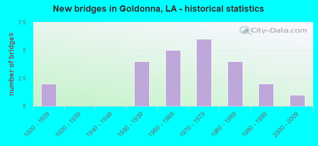
- New bridges - historical statistics
- 21920-1929
- 41950-1959
- 51960-1969
- 61970-1979
- 41980-1989
- 21990-1999
- 12000-2009

- Bridge Condition - Deck
- 4.5%Very good
- 18.2%Good
- 59.1%Satisfactory
- 13.6%Fair
- 4.5%Poor

- Bridge Condition - Superstructure
- 4.5%Very good
- 13.6%Good
- 63.6%Satisfactory
- 13.6%Fair
- 4.5%Poor

- Bridge Condition - Substructure
- 18.2%Good
- 22.7%Satisfactory
- 27.3%Fair
- 27.3%Poor
- 4.5%Critical

- Bridge Condition - Channel
- 4.2%Very good
- 29.2%Good
- 50.0%Satisfactory
- 12.5%Fair
- 4.2%Serious

- Bridge Condition - Culverts
- 50.0%Good
- 50.0%Satisfactory
Find on map >> Show street view
Structure Number: 80604000002404, Location: LOGMI 2.10 FR 428 TO (Lat: 32.064872, Lng: -92.851625), Route carried "on" structure: Federal lands road 502.2, Year Built: 1963, Status: Open, Structure Length: 0.94m (3.08ft), Average Daily Traffic: 16 (year 1975), Average Future Daily Traffic: 24 (year 2042), Design Load: HS 20, Features Intersected: S. FORK MILE CR., Facility Carried by Structure: FDR 502
Minimum Vertical Clearance: 30+ m (98+ ft), Kilometerpoint: 3.344, Lanes on structure: 1, Owner: U.S. Forest Service, Approaching Roadway Width: 6.1m (20.0ft), Material/Design: Prestressed concrete, Design/Construction: Channel Beam, Number Of Spans In Main Unit: 2, Length of Maximum Span: 4.6m (15.1ft), Curb or Sidewalk Widths: Left: 0.2m (0.7ft), Right: 0.2m (0.7ft), Curb-To-Curb Width: 4.6m (15.1ft), Out-to-Out Width: 5.1m (16.7ft)
Condition: Deck: Poor, Superstructure: Poor, Substructure: Critical, Channel: Satisfactory, Operating Rating: 30.8 metric tons, Method Used To Determine Operating Rating: Load and Resistance Factor Rating (LRFR) rating reported by rating factor(RF) method using HL-93 loadings, Inventory Rating: 20.4 metric tons, Method Used To Determine Inventory Rating: Load and Resistance Factor Rating (LRFR) rating reported by rating factor(RF) method using HL-93 loadings, Structural Evaluation: High priority of replacement, Deck Geometry: Better than present minimum criteria, Waterway Adequacy: Equal to present minimum criteria, Approach Roadway Alignment: Somewhat better than minimum adequacy, Designated Inspection Frequency: Every 12 months, Inspection Date: October 2021, Deck Structure Type: Other, Wearing Surface/Protective System: Wearing Surface: Integral Concrete
Find on map >> Show street view
Structure Number: 8060400000242, Location: NATIONAL FOREST ROAD (Lat: 32.021569, Lng: -92.968142), Route carried "on" structure: Federal lands road 524.2, Year Built: 1968, Status: Open, Structure Length: 1.07m (3.51ft), Average Daily Traffic: 10 (year 1979), Average Future Daily Traffic: 15 (year 2042), Design Load: HS 20, Features Intersected: MALAUDOS CREEK, Facility Carried by Structure: FDR 524
Minimum Vertical Clearance: 30+ m (98+ ft), Kilometerpoint: 3.408, Lanes on structure: 1, Owner: U.S. Forest Service, Approaching Roadway Width: 8.8m (28.9ft), Material/Design: Prestressed concrete, Design/Construction: Channel Beam, Number Of Spans In Main Unit: 2, Length of Maximum Span: 5.5m (18.0ft), Curb or Sidewalk Widths: Left: 0.1m (0.3ft), Right: 0.1m (0.3ft), Curb-To-Curb Width: 4.6m (15.1ft), Out-to-Out Width: 5.1m (16.7ft)
Condition: Deck: Satisfactory, Superstructure: Satisfactory, Substructure: Fair, Channel: Fair, Operating Rating: 27.9 metric tons, Method Used To Determine Operating Rating: Load and Resistance Factor Rating (LRFR) rating reported by rating factor(RF) method using HL-93 loadings, Inventory Rating: 19.1 metric tons, Method Used To Determine Inventory Rating: Load and Resistance Factor Rating (LRFR) rating reported by rating factor(RF) method using HL-93 loadings, Structural Evaluation: Somewhat better than minimum adequacy, Deck Geometry: Better than present minimum criteria, Waterway Adequacy: Equal to present minimum criteria, Approach Roadway Alignment: Equal to present desirable criteria, Designated Inspection Frequency: Every 12 months, Inspection Date: November 2021, Deck Structure Type: Other, Wearing Surface/Protective System: Wearing Surface: Integral Concrete
Find on map >> Show street view
Structure Number: 80604000002473, Location: NATIONAL FOREST ROAD (Lat: 32.037989, Lng: -92.942547), Route carried "on" structure: Federal lands road 570.3, Year Built: 1970, Status: Open, Structure Length: 1.07m (3.51ft), Average Daily Traffic: 30 (year 1976), Average Future Daily Traffic: 45 (year 2042), Design Load: HS 20, Features Intersected: LUSTER BRANCH, Facility Carried by Structure: FDR 570
Minimum Vertical Clearance: 30+ m (98+ ft), Kilometerpoint: 0.580, Lanes on structure: 2, Owner: U.S. Forest Service, Approaching Roadway Width: 8.2m (26.9ft), Material/Design: Prestressed concrete, Design/Construction: Channel Beam, Number Of Spans In Main Unit: 2, Length of Maximum Span: 5.5m (18.0ft), Curb or Sidewalk Widths: Left: 0.1m (0.3ft), Right: 0.1m (0.3ft), Curb-To-Curb Width: 7.2m (23.6ft), Out-to-Out Width: 7.7m (25.3ft)
Condition: Deck: Satisfactory, Superstructure: Satisfactory, Substructure: Satisfactory, Channel: Satisfactory, Operating Rating: 27.2 metric tons, Method Used To Determine Operating Rating: Load and Resistance Factor Rating (LRFR) rating reported by rating factor(RF) method using HL-93 loadings, Inventory Rating: 19.1 metric tons, Method Used To Determine Inventory Rating: Load and Resistance Factor Rating (LRFR) rating reported by rating factor(RF) method using HL-93 loadings, Structural Evaluation: Somewhat better than minimum adequacy, Deck Geometry: Somewhat better than minimum adequacy, Waterway Adequacy: Meets minimum limits, Approach Roadway Alignment: Equal to present desirable criteria, Designated Inspection Frequency: Every 24 months, Inspection Date: January 2021, Deck Structure Type: Other, Wearing Surface/Protective System: Wearing Surface: Integral Concrete
Find on map >> Show street view
Structure Number: 80604000002476, Location: NATIONAL FOREST ROAD (Lat: 32.053939, Lng: -92.936461), Route carried "on" structure: Federal lands road 570.1, Year Built: 1975, Status: Open, Structure Length: 1.40m (4.59ft), Average Daily Traffic: 30 (year 1976), Average Future Daily Traffic: 45 (year 2042), Design Load: HS 20, Features Intersected: RAGAN CREEK, Facility Carried by Structure: FDR 570
Minimum Vertical Clearance: 30+ m (98+ ft), Kilometerpoint: 2.507, Lanes on structure: 2, Owner: U.S. Forest Service, Approaching Roadway Width: 7.6m (24.9ft), Material/Design: Prestressed concrete, Design/Construction: Channel Beam, Number Of Spans In Main Unit: 3, Length of Maximum Span: 4.9m (16.1ft), Curb or Sidewalk Widths: Left: 0.2m (0.7ft), Right: 0.2m (0.7ft), Curb-To-Curb Width: 7.1m (23.3ft), Out-to-Out Width: 7.6m (24.9ft)
Condition: Deck: Satisfactory, Superstructure: Satisfactory, Substructure: Poor, Channel: Fair, Operating Rating: 27.2 metric tons, Method Used To Determine Operating Rating: Load and Resistance Factor Rating (LRFR) rating reported by rating factor(RF) method using HL-93 loadings, Inventory Rating: 17.2 metric tons, Method Used To Determine Inventory Rating: Load and Resistance Factor Rating (LRFR) rating reported by rating factor(RF) method using HL-93 loadings, Structural Evaluation: Meets minimum limits, Deck Geometry: Somewhat better than minimum adequacy, Waterway Adequacy: Meets minimum limits, Approach Roadway Alignment: Equal to present desirable criteria, Designated Inspection Frequency: Every 24 months, Inspection Date: January 2021, Deck Structure Type: Other, Wearing Surface/Protective System: Wearing Surface: Integral Concrete
Find on map >> Show street view
Structure Number: 80604000002477, Location: NATIONAL FOREST ROAD (Lat: 32.054664, Lng: -92.936850), Route carried "on" structure: Federal lands road 570.1, Year Built: 1968, Status: Open, Structure Length: 0.94m (3.08ft), Average Daily Traffic: 30 (year 1976), Average Future Daily Traffic: 45 (year 2042), Design Load: HS 20, Features Intersected: RAGAN CREEK, Facility Carried by Structure: FDR 570
Minimum Vertical Clearance: 30+ m (98+ ft), Kilometerpoint: 2.595, Lanes on structure: 2, Owner: U.S. Forest Service, Approaching Roadway Width: 8.5m (27.9ft), Material/Design: Prestressed concrete, Design/Construction: Channel Beam, Number Of Spans In Main Unit: 2, Length of Maximum Span: 4.9m (16.1ft), Curb or Sidewalk Widths: Left: 0.1m (0.3ft), Right: 0.1m (0.3ft), Curb-To-Curb Width: 7.2m (23.6ft), Out-to-Out Width: 7.7m (25.3ft)
Condition: Deck: Satisfactory, Superstructure: Satisfactory, Substructure: Poor, Channel: Satisfactory, Operating Rating: 27.2 metric tons, Method Used To Determine Operating Rating: Load and Resistance Factor Rating (LRFR) rating reported by rating factor(RF) method using HL-93 loadings, Inventory Rating: 17.2 metric tons, Method Used To Determine Inventory Rating: Load and Resistance Factor Rating (LRFR) rating reported by rating factor(RF) method using HL-93 loadings, Structural Evaluation: Meets minimum limits, Deck Geometry: Somewhat better than minimum adequacy, Waterway Adequacy: Meets minimum limits, Approach Roadway Alignment: Equal to present desirable criteria, Designated Inspection Frequency: Every 24 months, Inspection Date: January 2021, Deck Structure Type: Other, Wearing Surface/Protective System: Wearing Surface: Integral Concrete
Find on map >> Show street view
Structure Number: 80604000002478, Location: STRANGE ROAD (Lat: 32.073136, Lng: -92.938658), Route carried "on" structure: Federal lands road 570.2, Year Built: 1968, Status: Open, Structure Length: 1.40m (4.59ft), Average Daily Traffic: 30 (year 1976), Average Future Daily Traffic: 45 (year 2042), Design Load: HS 20, Features Intersected: SALINE BAYOU TRIB., Facility Carried by Structure: FDR 570
Minimum Vertical Clearance: 30+ m (98+ ft), Kilometerpoint: 4.846, Lanes on structure: 2, Owner: U.S. Forest Service, Approaching Roadway Width: 8.5m (27.9ft), Material/Design: Prestressed concrete, Design/Construction: Channel Beam, Number Of Spans In Main Unit: 3, Length of Maximum Span: 4.9m (16.1ft), Curb or Sidewalk Widths: Left: 0.1m (0.3ft), Right: 0.1m (0.3ft), Curb-To-Curb Width: 7.2m (23.6ft), Out-to-Out Width: 7.6m (24.9ft)
Condition: Deck: Satisfactory, Superstructure: Satisfactory, Substructure: Fair, Channel: Satisfactory, Operating Rating: 28.2 metric tons, Method Used To Determine Operating Rating: Load and Resistance Factor Rating (LRFR) rating reported by rating factor(RF) method using HL-93 loadings, Inventory Rating: 20.1 metric tons, Method Used To Determine Inventory Rating: Load and Resistance Factor Rating (LRFR) rating reported by rating factor(RF) method using HL-93 loadings, Structural Evaluation: Somewhat better than minimum adequacy, Deck Geometry: Somewhat better than minimum adequacy, Waterway Adequacy: Meets minimum limits, Approach Roadway Alignment: Equal to present desirable criteria, Designated Inspection Frequency: Every 24 months, Inspection Date: January 2021, Deck Structure Type: Other, Wearing Surface/Protective System: Wearing Surface: Integral Concrete
Find on map >> Show street view
Structure Number: 80604000002479, Location: STRANGE ROAD RT. 570 (Lat: 32.090094, Lng: -92.954061), Route carried "on" structure: Federal lands road 570.4, Year Built: 1970, Status: Open, Structure Length: 1.40m (4.59ft), Average Daily Traffic: 30 (year 1976), Average Future Daily Traffic: 45 (year 2042), Design Load: HS 20, Features Intersected: CHOCTAW CREEK, Facility Carried by Structure: FDR 570
Minimum Vertical Clearance: 30+ m (98+ ft), Kilometerpoint: 7.657, Lanes on structure: 2, Owner: U.S. Forest Service, Approaching Roadway Width: 8.5m (27.9ft), Material/Design: Prestressed concrete, Design/Construction: Channel Beam, Number Of Spans In Main Unit: 3, Length of Maximum Span: 4.9m (16.1ft), Curb or Sidewalk Widths: Left: 0.1m (0.3ft), Right: 0.1m (0.3ft), Curb-To-Curb Width: 7.3m (24.0ft), Out-to-Out Width: 7.7m (25.3ft)
Condition: Deck: Satisfactory, Superstructure: Satisfactory, Substructure: Fair, Channel: Satisfactory, Operating Rating: 28.2 metric tons, Method Used To Determine Operating Rating: Load and Resistance Factor Rating (LRFR) rating reported by rating factor(RF) method using HL-93 loadings, Inventory Rating: 20.1 metric tons, Method Used To Determine Inventory Rating: Load and Resistance Factor Rating (LRFR) rating reported by rating factor(RF) method using HL-93 loadings, Structural Evaluation: Somewhat better than minimum adequacy, Deck Geometry: Equal to present minimum criteria, Waterway Adequacy: Equal to present minimum criteria, Approach Roadway Alignment: Equal to present desirable criteria, Designated Inspection Frequency: Every 24 months, Inspection Date: January 2021, Deck Structure Type: Other, Wearing Surface/Protective System: Wearing Surface: Integral Concrete
Find on map >> Show street view
Structure Number: 8060400000248, Location: NATIONAL FOREST ROAD (Lat: 32.090983, Lng: -92.954706), Route carried "on" structure: Federal lands road 570, Year Built: 1970, Status: Open, Structure Length: 1.40m (4.59ft), Average Daily Traffic: 30 (year 1976), Average Future Daily Traffic: 45 (year 2042), Design Load: HS 20, Features Intersected: CHOCTAW CREEK
Minimum Vertical Clearance: 30+ m (98+ ft), Kilometerpoint: 7.772, Lanes on structure: 2, Owner: U.S. Forest Service, Approaching Roadway Width: 8.8m (28.9ft), Material/Design: Prestressed concrete, Design/Construction: Channel Beam, Number Of Spans In Main Unit: 3, Length of Maximum Span: 4.9m (16.1ft), Curb or Sidewalk Widths: Left: 0.1m (0.3ft), Right: 0.1m (0.3ft), Curb-To-Curb Width: 7.2m (23.6ft), Out-to-Out Width: 7.7m (25.3ft)
Condition: Deck: Satisfactory, Superstructure: Satisfactory, Substructure: Poor, Channel: Serious, Operating Rating: 28.2 metric tons, Method Used To Determine Operating Rating: Load and Resistance Factor Rating (LRFR) rating reported by rating factor(RF) method using HL-93 loadings, Inventory Rating: 20.1 metric tons, Method Used To Determine Inventory Rating: Load and Resistance Factor Rating (LRFR) rating reported by rating factor(RF) method using HL-93 loadings, Structural Evaluation: Meets minimum limits, Deck Geometry: Somewhat better than minimum adequacy, Waterway Adequacy: Equal to present minimum criteria, Approach Roadway Alignment: Equal to present desirable criteria, Designated Inspection Frequency: Every 24 months, Inspection Date: January 2021, Deck Structure Type: Other, Wearing Surface/Protective System: Wearing Surface: Integral Concrete
Find on map >> Show street view
Structure Number: 80604000002481, Location: 2 MI. N. OF GOLDONNA (Lat: 32.049242, Lng: -92.911964), Route carried "on" structure: Federal lands road 585.2, Year Built: 1970, Status: Open, Structure Length: 1.22m (4.00ft), Average Daily Traffic: 30 (year 1996), Average Future Daily Traffic: 45 (year 2042), Design Load: H 20, Features Intersected: RAGAN CREEK, Facility Carried by Structure: FDR 585
Minimum Vertical Clearance: 30+ m (98+ ft), Kilometerpoint: 3.928, Lanes on structure: 2, Owner: U.S. Forest Service, Approaching Roadway Width: 7.3m (24.0ft), Material/Design: Prestressed concrete, Design/Construction: Channel Beam, Number Of Spans In Main Unit: 2, Length of Maximum Span: 6.1m (20.0ft), Curb or Sidewalk Widths: Left: 0.1m (0.3ft), Right: 0.1m (0.3ft), Curb-To-Curb Width: 7.1m (23.3ft), Out-to-Out Width: 7.6m (24.9ft)
Condition: Deck: Satisfactory, Superstructure: Satisfactory, Substructure: Poor, Channel: Satisfactory, Operating Rating: 25.6 metric tons, Method Used To Determine Operating Rating: Load and Resistance Factor Rating (LRFR) rating reported by rating factor(RF) method using HL-93 loadings, Inventory Rating: 18.1 metric tons, Method Used To Determine Inventory Rating: Load and Resistance Factor Rating (LRFR) rating reported by rating factor(RF) method using HL-93 loadings, Structural Evaluation: Meets minimum limits, Deck Geometry: Somewhat better than minimum adequacy, Waterway Adequacy: Meets minimum limits, Approach Roadway Alignment: Equal to present desirable criteria, Designated Inspection Frequency: Every 24 months, Inspection Date: January 2021, Deck Structure Type: Other, Wearing Surface/Protective System: Wearing Surface: Integral Concrete
Find on map >> Show street view
Structure Number: 80604000003109, Location: NATIONAL FOREST ROAD (Lat: 32.083617, Lng: -92.905239), Route carried "on" structure: Federal lands road 513, Year Built: 2003, Status: Open, Structure Length: 4.05m (13.29ft), Average Daily Traffic: 30 (year 2003), Average Future Daily Traffic: 45 (year 2042), Design Load: HS 20, Features Intersected: SALINE BAYOU
Minimum Vertical Clearance: 30+ m (98+ ft), Kilometerpoint: 5.905, Lanes on structure: 2, Owner: U.S. Forest Service, Approaching Roadway Width: 7.3m (24.0ft), Material/Design: Concrete, Design/Construction: Slab, Number Of Spans In Main Unit: 7, Length of Maximum Span: 5.8m (19.0ft), Curb-To-Curb Width: 7.3m (24.0ft), Out-to-Out Width: 8.2m (26.9ft)
Condition: Deck: Very good, Superstructure: Very good, Substructure: Good, Channel: Good, Operating Rating: 27.2 metric tons, Method Used To Determine Operating Rating: Load and Resistance Factor Rating (LRFR) rating reported by rating factor(RF) method using HL-93 loadings, Inventory Rating: 18.1 metric tons, Method Used To Determine Inventory Rating: Load and Resistance Factor Rating (LRFR) rating reported by rating factor(RF) method using HL-93 loadings, Structural Evaluation: Somewhat better than minimum adequacy, Deck Geometry: Equal to present minimum criteria, Waterway Adequacy: Equal to present minimum criteria, Approach Roadway Alignment: Equal to present desirable criteria, Designated Inspection Frequency: Every 48 months, Inspection Date: January 2021, Deck Structure Type: Other, Wearing Surface/Protective System: Wearing Surface: Integral Concrete
Find on map >> Show street view
Structure Number: 83500910200001, Location: 3.9 MI. W OF INT LA153 (Lat: 32.094289, Lng: -93.162439), Route carried "on" structure: State highway 155, Year Built: 1992, Status: Open, Structure Length: 10.97m (35.99ft), Average Daily Traffic: 640 (year 2016), Truck Traffic: 14%, Average Future Daily Traffic: 403 (year 2036), Design Load: HS 20, Features Intersected: BLACK LAKE BAYOU
Minimum Vertical Clearance: 30+ m (98+ ft), Kilometerpoint: 0.000, Lanes on structure: 2, Owner: State Highway Agency, Approaching Roadway Width: 7.9m (25.9ft), Skew: 30 degrees, Material/Design: Concrete, Design/Construction: Slab, Number Of Spans In Main Unit: 18, Length of Maximum Span: 6.1m (20.0ft), Curb-To-Curb Width: 9.1m (29.9ft), Out-to-Out Width: 10.0m (32.8ft)
Condition: Deck: Good, Superstructure: Good, Substructure: Good, Channel: Very good, Operating Rating: 66.2 metric tons, Method Used To Determine Operating Rating: Load Factor (LF), Inventory Rating: 39.0 metric tons, Method Used To Determine Inventory Rating: Load Factor (LF), Structural Evaluation: Better than present minimum criteria, Deck Geometry: Equal to present minimum criteria, Waterway Adequacy: Equal to present desirable criteria, Approach Roadway Alignment: Superior to present desirable criteria, Designated Inspection Frequency: Every 24 months, Inspection Date: January 2022, Deck Structure Type: Concrete Cast-file-Place, Wearing Surface/Protective System: Wearing Surface: Monolithic Concrete
Find on map >> Show street view
Structure Number: 83500920105961, Location: 5.9 MI. E OF INT LA9 (Lat: 31.991319, Lng: -92.964600), Route carried "on" structure: State highway 156, Year Built: 1926, Status: Open, Structure Length: 0.82m (2.69ft), Average Daily Traffic: 550 (year 2016), Truck Traffic: 14%, Average Future Daily Traffic: 453 (year 2036), Design Load: H 15, Features Intersected: CREEK
Minimum Vertical Clearance: 30+ m (98+ ft), Kilometerpoint: 9.429, Lanes on structure: 2, Owner: State Highway Agency, Approaching Roadway Width: 7.9m (25.9ft), Skew: 30 degrees, Material/Design: Concrete, Design/Construction: Culvert, Number Of Spans In Main Unit: 4, Length of Maximum Span: 1.8m (5.9ft)
Condition: Channel: Fair, Culverts: Satisfactory, Operating Rating: 42.1 metric tons, Method Used To Determine Operating Rating: Load and Resistance Factor Rating (LRFR) rating reported by rating factor(RF) method using HL-93 loadings, Inventory Rating: 32.4 metric tons, Method Used To Determine Inventory Rating: Load and Resistance Factor Rating (LRFR) rating reported by rating factor(RF) method using HL-93 loadings, Structural Evaluation: Equal to present minimum criteria, Waterway Adequacy: Somewhat better than minimum adequacy, Approach Roadway Alignment: Better than present minimum criteria, Designated Inspection Frequency: Every 24 months, Inspection Date: January 2022, Deck Structure Type: Concrete Cast-file-Place
Find on map >> Show street view
Structure Number: 83500920109711, Location: 9.7 MI. E OF INT LA9 (Lat: 32.011481, Lng: -92.909400), Route carried "on" structure: State highway 156, Year Built: 1926, Status: Open, Structure Length: 2.38m (7.81ft), Average Daily Traffic: 550 (year 2016), Truck Traffic: 14%, Average Future Daily Traffic: 453 (year 2036), Design Load: H 10, Features Intersected: CREEK
Minimum Vertical Clearance: 30+ m (98+ ft), Kilometerpoint: 15.435, Lanes on structure: 2, Owner: State Highway Agency, Approaching Roadway Width: 7.9m (25.9ft), Skew: 30 degrees, Material/Design: Wood or Timber, Design/Construction: Stringer/Multi-beam, Number Of Spans In Main Unit: 4, Length of Maximum Span: 5.8m (19.0ft), Curb-To-Curb Width: 5.7m (18.7ft), Out-to-Out Width: 6.1m (20.0ft)
Condition: Deck: Good, Superstructure: Satisfactory, Substructure: Poor, Channel: Satisfactory, Operating Rating: 32.7 metric tons, Method Used To Determine Operating Rating: Allowable Stress (AS), Inventory Rating: 22.7 metric tons, Method Used To Determine Inventory Rating: Allowable Stress (AS), Structural Evaluation: Meets minimum limits, Deck Geometry: High priority of replacement, Waterway Adequacy: Better than present minimum criteria, Approach Roadway Alignment: Equal to present minimum criteria, Length Of Structure Improvement: 3.14m (10.30ft), Designated Inspection Frequency: Every 24 months, Other Special Inspection Frequency: Every 12 months, Inspection Date: January 2022, Other Special Inspection Date: January 2021, Bridge Improvement Cost: $267,000, Total Project Cost: $400,000 ( Estimate for 2016), Deck Structure Type: Wood or Timber, Wearing Surface/Protective System: Wearing Surface: Bituminous
Find on map >> Show street view
Structure Number: 83500920110181, Location: 10.18 MI. E OF INT LA9 (Lat: 32.013100, Lng: -92.905900), Route carried "on" structure: State highway 156, Year Built: 1956, Status: Open, Structure Length: 3.66m (12.01ft), Average Daily Traffic: 600 (year 2016), Truck Traffic: 14%, Average Future Daily Traffic: 460 (year 2036), Design Load: H 15, Features Intersected: MOLINA CREEK
Minimum Vertical Clearance: 30+ m (98+ ft), Kilometerpoint: 16.114, Lanes on structure: 2, Owner: State Highway Agency, Approaching Roadway Width: 7.9m (25.9ft), Skew: 30 degrees, Material/Design: Concrete, Design/Construction: Slab, Number Of Spans In Main Unit: 6, Length of Maximum Span: 6.1m (20.0ft), Curb-To-Curb Width: 7.3m (24.0ft), Out-to-Out Width: 8.8m (28.9ft)
Condition: Deck: Good, Superstructure: Good, Substructure: Satisfactory, Channel: Good, Operating Rating: 32.7 metric tons, Method Used To Determine Operating Rating: Load Factor (LF), Inventory Rating: 19.0 metric tons, Method Used To Determine Inventory Rating: Load Factor (LF), Structural Evaluation: Somewhat better than minimum adequacy, Deck Geometry: Meets minimum limits, Waterway Adequacy: Equal to present minimum criteria, Approach Roadway Alignment: Equal to present minimum criteria, Designated Inspection Frequency: Every 24 months, Inspection Date: January 2022, Deck Structure Type: Concrete Cast-file-Place, Wearing Surface/Protective System: Wearing Surface: Bituminous
Find on map >> Show street view
Structure Number: 83503580202401, Location: 2.4 MI. E OF INT LA9 (Lat: 32.054319, Lng: -92.979000), Route carried "on" structure: State highway 479, Year Built: 1985, Status: Open, Structure Length: 1.74m (5.71ft), Average Daily Traffic: 210 (year 2016), Truck Traffic: 14%, Average Future Daily Traffic: 144 (year 2036), Design Load: HS 20, Features Intersected: RAGAN CREEK
Minimum Vertical Clearance: 30+ m (98+ ft), Kilometerpoint: 3.534, Lanes on structure: 2, Owner: State Highway Agency, Approaching Roadway Width: 8.5m (27.9ft), Skew: 30 degrees, Material/Design: Concrete, Design/Construction: Slab, Number Of Spans In Main Unit: 3, Length of Maximum Span: 5.8m (19.0ft), Curb-To-Curb Width: 8.6m (28.2ft), Out-to-Out Width: 9.4m (30.8ft)
Condition: Deck: Fair, Superstructure: Fair, Substructure: Fair, Channel: Satisfactory, Operating Rating: 63.5 metric tons, Method Used To Determine Operating Rating: Load Factor (LF), Inventory Rating: 38.1 metric tons, Method Used To Determine Inventory Rating: Load Factor (LF), Structural Evaluation: Somewhat better than minimum adequacy, Deck Geometry: Equal to present minimum criteria, Waterway Adequacy: Better than present minimum criteria, Approach Roadway Alignment: Better than present minimum criteria, Designated Inspection Frequency: Every 24 months, Inspection Date: January 2022, Deck Structure Type: Concrete Precast Panels, Wearing Surface/Protective System: Wearing Surface: Bituminous
Find on map >> Show street view
Structure Number: 83503580202901, Location: 2.9 MI. E OF INT LA9 (Lat: 32.049650, Lng: -92.971600), Route carried "on" structure: State highway 479, Year Built: 1985, Status: Open, Structure Length: 1.74m (5.71ft), Average Daily Traffic: 210 (year 2016), Truck Traffic: 14%, Average Future Daily Traffic: 144 (year 2036), Design Load: HS 20, Features Intersected: RAGAN CREEK RELIEF
Minimum Vertical Clearance: 30+ m (98+ ft), Kilometerpoint: 4.413, Lanes on structure: 2, Owner: State Highway Agency, Approaching Roadway Width: 8.5m (27.9ft), Skew: 30 degrees, Material/Design: Concrete, Design/Construction: Slab, Number Of Spans In Main Unit: 3, Length of Maximum Span: 5.8m (19.0ft), Curb-To-Curb Width: 8.6m (28.2ft), Out-to-Out Width: 9.4m (30.8ft)
Condition: Deck: Satisfactory, Superstructure: Satisfactory, Substructure: Good, Channel: Good, Operating Rating: 63.5 metric tons, Method Used To Determine Operating Rating: Load Factor (LF), Inventory Rating: 38.1 metric tons, Method Used To Determine Inventory Rating: Load Factor (LF), Structural Evaluation: Equal to present minimum criteria, Deck Geometry: Equal to present minimum criteria, Waterway Adequacy: Equal to present desirable criteria, Approach Roadway Alignment: Equal to present minimum criteria, Designated Inspection Frequency: Every 24 months, Inspection Date: January 2022, Deck Structure Type: Concrete Precast Panels, Wearing Surface/Protective System: Wearing Surface: Bituminous
Find on map >> Show street view
Structure Number: 83503580204601, Location: 4.6 MI. E OF INT LA9 (Lat: 32.035881, Lng: -92.949200), Route carried "on" structure: State highway 479, Year Built: 1985, Status: Open, Structure Length: 1.16m (3.81ft), Average Daily Traffic: 210 (year 2016), Truck Traffic: 14%, Average Future Daily Traffic: 144 (year 2036), Design Load: HS 20, Features Intersected: LUSTER CREEK
Minimum Vertical Clearance: 30+ m (98+ ft), Kilometerpoint: 7.089, Lanes on structure: 2, Owner: State Highway Agency, Approaching Roadway Width: 8.5m (27.9ft), Skew: 30 degrees, Material/Design: Concrete, Design/Construction: Slab, Number Of Spans In Main Unit: 2, Length of Maximum Span: 5.8m (19.0ft), Curb-To-Curb Width: 8.6m (28.2ft), Out-to-Out Width: 9.4m (30.8ft)
Condition: Deck: Fair, Superstructure: Fair, Substructure: Satisfactory, Channel: Satisfactory, Operating Rating: 63.5 metric tons, Method Used To Determine Operating Rating: Load Factor (LF), Inventory Rating: 38.1 metric tons, Method Used To Determine Inventory Rating: Load Factor (LF), Structural Evaluation: Somewhat better than minimum adequacy, Deck Geometry: Equal to present minimum criteria, Waterway Adequacy: Equal to present desirable criteria, Approach Roadway Alignment: Equal to present desirable criteria, Designated Inspection Frequency: Every 24 months, Inspection Date: January 2022, Deck Structure Type: Concrete Precast Panels, Wearing Surface/Protective System: Wearing Surface: Bituminous
Find on map >> Show street view
Structure Number: 83531571925591, Location: 6 M. N. OF END MAINT. LA (Lat: 31.950850, Lng: -92.931500), Route carried "on" structure: County highway , Year Built: 1995, Status: Posted for load, Structure Length: 1.74m (5.71ft), Average Daily Traffic: 230 (year 1993), Average Future Daily Traffic: 165 (year 2036), Design Load: HS 20, Features Intersected: LITTLE FORDOCHE CREEK, Facility Carried by Structure: Goldonna Rd
Minimum Vertical Clearance: 30+ m (98+ ft), Kilometerpoint: 9.442, Lanes on structure: 2, Owner: County Highway Agency, Approaching Roadway Width: 6.1m (20.0ft), Skew: 36 degrees, Material/Design: Concrete, Design/Construction: Slab, Number Of Spans In Main Unit: 3, Length of Maximum Span: 5.8m (19.0ft), Curb-To-Curb Width: 7.3m (24.0ft), Out-to-Out Width: 8.2m (26.9ft)
Condition: Deck: Satisfactory, Superstructure: Satisfactory, Substructure: Satisfactory, Channel: Good, Operating Rating: 47.0 metric tons, Method Used To Determine Operating Rating: Load and Resistance Factor Rating (LRFR) rating reported by rating factor(RF) method using HL-93 loadings, Inventory Rating: 36.3 metric tons, Method Used To Determine Inventory Rating: Load and Resistance Factor Rating (LRFR) rating reported by rating factor(RF) method using HL-93 loadings, Structural Evaluation: Equal to present minimum criteria, Deck Geometry: Somewhat better than minimum adequacy, Waterway Adequacy: Equal to present desirable criteria, Approach Roadway Alignment: Better than present minimum criteria, Designated Inspection Frequency: Every 24 months, Inspection Date: December 2020, Deck Structure Type: Concrete Precast Panels
Find on map >> Show street view
Structure Number: 83531571925671, Location: 1.45 M. SW OF GOLDONNA RO (Lat: 31.952381, Lng: -92.944500), Route carried "on" structure: County highway , Year Built: 1970, Status: Open, Structure Length: 0.76m (2.49ft), Average Daily Traffic: 100 (year 1976), Average Future Daily Traffic: 72 (year 2036), Design Load: HS 20, Features Intersected: LITTLE FORDOCHE CREEK, Facility Carried by Structure: Rice Rd
Minimum Vertical Clearance: 30+ m (98+ ft), Kilometerpoint: 1.698, Lanes on structure: 2, Owner: County Highway Agency, Approaching Roadway Width: 7.3m (24.0ft), Skew: 30 degrees, Material/Design: Prestressed concrete, Design/Construction: Channel Beam, Number Of Spans In Main Unit: 1, Length of Maximum Span: 7.6m (24.9ft), Curb-To-Curb Width: 5.5m (18.0ft), Out-to-Out Width: 5.9m (19.4ft)
Condition: Deck: Fair, Superstructure: Fair, Substructure: Fair, Channel: Satisfactory, Operating Rating: 46.3 metric tons, Method Used To Determine Operating Rating: Allowable Stress (AS), Inventory Rating: 19.0 metric tons, Method Used To Determine Inventory Rating: Allowable Stress (AS), Structural Evaluation: Somewhat better than minimum adequacy, Deck Geometry: Meets minimum limits, Waterway Adequacy: Somewhat better than minimum adequacy, Approach Roadway Alignment: Equal to present minimum criteria, Designated Inspection Frequency: Every 24 months, Inspection Date: December 2020, Deck Structure Type: Concrete Precast Panels, Wearing Surface/Protective System: Wearing Surface: Monolithic Concrete
Find on map >> Show street view
Structure Number: 83531582925551, Location: 3.50 M. S. OF LA 156 (Lat: 31.968611, Lng: -92.925000), Route carried "on" structure: County highway , Year Built: 1984, Status: Open, Structure Length: 1.74m (5.71ft), Average Daily Traffic: 170 (year 1976), Average Future Daily Traffic: 122 (year 2036), Design Load: HS 20, Features Intersected: BIG FORDOCHE CREEK, Facility Carried by Structure: Goldonna Rd
Minimum Vertical Clearance: 30+ m (98+ ft), Kilometerpoint: 11.515, Lanes on structure: 2, Owner: County Highway Agency, Approaching Roadway Width: 7.6m (24.9ft), Skew: 30 degrees, Material/Design: Concrete, Design/Construction: Slab, Number Of Spans In Main Unit: 3, Length of Maximum Span: 5.8m (19.0ft), Curb-To-Curb Width: 7.3m (24.0ft), Out-to-Out Width: 8.2m (26.9ft)
Condition: Deck: Good, Superstructure: Good, Substructure: Good, Channel: Good, Operating Rating: 33.7 metric tons, Method Used To Determine Operating Rating: Load and Resistance Factor Rating (LRFR) rating reported by rating factor(RF) method using HL-93 loadings, Inventory Rating: 25.9 metric tons, Method Used To Determine Inventory Rating: Load and Resistance Factor Rating (LRFR) rating reported by rating factor(RF) method using HL-93 loadings, Structural Evaluation: Equal to present minimum criteria, Deck Geometry: Somewhat better than minimum adequacy, Waterway Adequacy: Equal to present minimum criteria, Approach Roadway Alignment: Equal to present minimum criteria, Designated Inspection Frequency: Every 24 months, Inspection Date: December 2020, Deck Structure Type: Concrete Cast-file-Place, Wearing Surface/Protective System: Wearing Surface: Monolithic Concrete
Find on map >> Show street view
Structure Number: 86400920200001, Location: 0.92 MI. WEST OF LA 1233 (Lat: 32.000419, Lng: -92.894789), Route carried "on" structure: State highway 156, Year Built: 1952, Status: Open, Structure Length: 13.41m (44.00ft), Average Daily Traffic: 850 (year 2016), Truck Traffic: 14%, Average Future Daily Traffic: 1,462 (year 2036), Design Load: H 15, Features Intersected: SALINE BAYOU
Minimum Vertical Clearance: 30+ m (98+ ft), Kilometerpoint: 0.000, Lanes on structure: 2, Owner: State Highway Agency, Approaching Roadway Width: 9.1m (29.9ft), Skew: 30 degrees, Material/Design: Concrete, Design/Construction: Slab, Number Of Spans In Main Unit: 22, Length of Maximum Span: 6.1m (20.0ft), Curb-To-Curb Width: 7.3m (24.0ft), Out-to-Out Width: 8.8m (28.9ft)
Condition: Deck: Satisfactory, Superstructure: Satisfactory, Substructure: Poor, Channel: Satisfactory, Operating Rating: 35.4 metric tons, Method Used To Determine Operating Rating: Load Factor (LF), Inventory Rating: 20.9 metric tons, Method Used To Determine Inventory Rating: Load Factor (LF), Structural Evaluation: Meets minimum limits, Deck Geometry: Meets minimum limits, Waterway Adequacy: Equal to present desirable criteria, Approach Roadway Alignment: Better than present minimum criteria, Designated Inspection Frequency: Every 24 months, Underwater Inspection Frequency: Every 60 months, Other Special Inspection Frequency: Every 12 months, Inspection Date: September 2021, Underwater Inspection Date: March 2018, Deck Structure Type: Concrete Cast-file-Place, Wearing Surface/Protective System: Wearing Surface: Monolithic Concrete
Find on map >> Show street view
Structure Number: 86400920201361, Location: 0.44 MI. WEST OF LA 1233 (Lat: 31.989369, Lng: -92.875600), Route carried "on" structure: State highway 156, Year Built: 1952, Status: Open, Structure Length: 0.64m (2.10ft), Average Daily Traffic: 850 (year 2016), Truck Traffic: 14%, Average Future Daily Traffic: 1,462 (year 2036), Design Load: H 15, Features Intersected: SPRING BRANCH
Minimum Vertical Clearance: 30+ m (98+ ft), Kilometerpoint: 2.192, Lanes on structure: 2, Owner: State Highway Agency, Approaching Roadway Width: 9.1m (29.9ft), Skew: 30 degrees, Material/Design: Concrete, Design/Construction: Culvert, Number Of Spans In Main Unit: 2, Length of Maximum Span: 3.0m (9.8ft)
Condition: Channel: Good, Culverts: Good, Operating Rating: 42.1 metric tons, Method Used To Determine Operating Rating: Load and Resistance Factor Rating (LRFR) rating reported by rating factor(RF) method using HL-93 loadings, Inventory Rating: 32.4 metric tons, Method Used To Determine Inventory Rating: Load and Resistance Factor Rating (LRFR) rating reported by rating factor(RF) method using HL-93 loadings, Structural Evaluation: Better than present minimum criteria, Waterway Adequacy: Equal to present desirable criteria, Approach Roadway Alignment: Better than present minimum criteria, Designated Inspection Frequency: Every 24 months, Inspection Date: September 2021, Deck Structure Type: Concrete Cast-file-Place
Find on map >> Show street view
Structure Number: 86400920202491, Location: 1.57 MI. EAST OF LA 1233 (Lat: 31.979269, Lng: -92.860400), Route carried "on" structure: State highway 156, Year Built: 1952, Status: Open, Structure Length: 2.47m (8.10ft), Average Daily Traffic: 850 (year 2016), Truck Traffic: 14%, Average Future Daily Traffic: 1,462 (year 2036), Design Load: H 15, Features Intersected: HURRICANE CREEK
Minimum Vertical Clearance: 30+ m (98+ ft), Kilometerpoint: 4.023, Lanes on structure: 2, Owner: State Highway Agency, Approaching Roadway Width: 9.4m (30.8ft), Skew: 30 degrees, Material/Design: Concrete, Design/Construction: Slab, Number Of Spans In Main Unit: 4, Length of Maximum Span: 6.1m (20.0ft), Curb-To-Curb Width: 7.3m (24.0ft), Out-to-Out Width: 8.8m (28.9ft)
Condition: Deck: Satisfactory, Superstructure: Satisfactory, Substructure: Satisfactory, Channel: Good, Operating Rating: 30.8 metric tons, Method Used To Determine Operating Rating: Load Factor (LF), Inventory Rating: 18.1 metric tons, Method Used To Determine Inventory Rating: Load Factor (LF), Structural Evaluation: Somewhat better than minimum adequacy, Deck Geometry: Meets minimum limits, Waterway Adequacy: Equal to present desirable criteria, Approach Roadway Alignment: Better than present minimum criteria, Designated Inspection Frequency: Every 24 months, Inspection Date: September 2021, Deck Structure Type: Concrete Cast-file-Place, Wearing Surface/Protective System: Wearing Surface: Bituminous
Find on map >> Show street view
Structure Number: 86432023925141, Location: 0.32 MI. EAST OF LA 1233 (Lat: 32.038569, Lng: -92.859000), Route carried "on" structure: County highway , Year Built: 1965, Status: Open, Structure Length: 1.04m (3.41ft), Average Daily Traffic: 50 (year 1975), Average Future Daily Traffic: 85 (year 2036), Design Load: HS 20, Features Intersected: Yankee Springs Creek, Facility Carried by Structure: Yankee Springs
Minimum Vertical Clearance: 30+ m (98+ ft), Kilometerpoint: 0.499, Lanes on structure: 2, Owner: County Highway Agency, Approaching Roadway Width: 7.0m (23.0ft), Skew: 30 degrees, Material/Design: Prestressed concrete, Design/Construction: Channel Beam, Number Of Spans In Main Unit: 2, Length of Maximum Span: 5.2m (17.1ft), Curb-To-Curb Width: 7.1m (23.3ft), Out-to-Out Width: 7.6m (24.9ft)
Condition: Deck: Satisfactory, Superstructure: Satisfactory, Substructure: Fair, Channel: Satisfactory, Operating Rating: 33.7 metric tons, Method Used To Determine Operating Rating: Load and Resistance Factor Rating (LRFR) rating reported by rating factor(RF) method using HL-93 loadings, Inventory Rating: 21.4 metric tons, Method Used To Determine Inventory Rating: Load and Resistance Factor Rating (LRFR) rating reported by rating factor(RF) method using HL-93 loadings, Structural Evaluation: Somewhat better than minimum adequacy, Deck Geometry: Somewhat better than minimum adequacy, Waterway Adequacy: Equal to present minimum criteria, Approach Roadway Alignment: Equal to present minimum criteria, Designated Inspection Frequency: Every 24 months, Inspection Date: October 2020, Deck Structure Type: Concrete Cast-file-Place, Wearing Surface/Protective System: Wearing Surface: Monolithic Concrete