Bridge Statistics for Goshen, California (CA)
Condition, Traffic, Stress, Structural Evaluation, Project Costs
- National Bridge Inventory (NBI) Statistics
- 20Number of bridges
- 223ft / 67.6mTotal length
- 453,200Total average daily traffic
- 120,427Total average daily truck traffic
- National Bridge Inventory (NBI) Registered Bridges for Goshen
- No street view available for this location
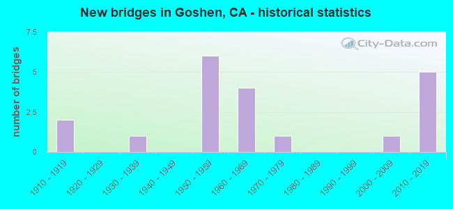
- New bridges - historical statistics
- 21910-1919
- 11930-1939
- 61950-1959
- 41960-1969
- 11970-1979
- 12000-2009
- 52010-2019

- Reconstructed bridges - Historical Statistics
- 92000-2009
- 12010-2019


- Bridge Condition - Deck
- 90.0%Good
- 10.0%Fair

- Bridge Condition - Superstructure
- 90.0%Good
- 10.0%Fair

- Bridge Condition - Substructure
- 80.0%Good
- 20.0%Fair

- Bridge Condition - Channel
- 54.5%Good
- 45.5%Satisfactory

- Bridge Condition - Culverts
- 66.7%Good
- 33.3%Satisfactory
Find on map >> Show street view
Structure Number: 46 0030L, Location: 06-TUL-099-44.62 (Lat: 36.401003, Lng: -119.454364), Route carried "on" structure: State highway 99, Year Built: 1951, Year Reconstructed: 2013, Status: Open, Structure Length: 2.96m (9.71ft), Average Daily Traffic: 24,500 (year 2009), Truck Traffic: 35%, Average Future Daily Traffic: 51,333 (year 2042), Features Intersected: CROSS CREEK
Minimum Vertical Clearance: 30+ m (98+ ft), Kilometerpoint: 44.620, Lanes on structure: 2, Base Highway Network: Yes (, Subroute: 1), Owner: State Highway Agency, Approaching Roadway Width: 18.2m (59.7ft), Material/Design: Concrete continuous, Design/Construction: Culvert, Number Of Spans In Main Unit: 9, Length of Maximum Span: 3.4m (11.2ft), Curb-To-Curb Width: 17.2m (56.4ft), Out-to-Out Width: 18.2m (59.7ft)
Condition: Channel: Satisfactory, Culverts: Good, Operating Rating: 54.1 metric tons, Method Used To Determine Operating Rating: Field evaluation and documented engineering judgment, Inventory Rating: 32.4 metric tons, Method Used To Determine Inventory Rating: Field evaluation and documented engineering judgment, Structural Evaluation: Better than present minimum criteria, Deck Geometry: Superior to present desirable criteria, Waterway Adequacy: Equal to present minimum criteria, Approach Roadway Alignment: Equal to present desirable criteria, Designated Inspection Frequency: Every 24 months, Inspection Date: October 2020, Deck Structure Type: Concrete Cast-file-Place, Wearing Surface/Protective System: Wearing Surface: Bituminous
Find on map >> Show street view
Structure Number: 46 0030R, Location: 06-TUL-099-44.62 (Lat: 36.401069, Lng: -119.454044), Route carried "on" structure: State highway 99, Year Built: 1916, Year Reconstructed: 2013, Status: Open, Structure Length: 3.05m (10.01ft), Average Daily Traffic: 24,500 (year 2009), Truck Traffic: 35%, Average Future Daily Traffic: 51,333 (year 2042), Features Intersected: CROSS CREEK
Minimum Vertical Clearance: 30+ m (98+ ft), Kilometerpoint: 44.620, Lanes on structure: 3, Base Highway Network: Yes (, Subroute: 1), Owner: State Highway Agency, Approaching Roadway Width: 18.9m (62.0ft), Material/Design: Concrete continuous, Design/Construction: Slab, Number Of Spans In Main Unit: 7, Length of Maximum Span: 4.4m (14.4ft), Curb-To-Curb Width: 18.4m (60.4ft), Out-to-Out Width: 19.3m (63.3ft)
Condition: Deck: Good, Superstructure: Good, Substructure: Fair, Channel: Satisfactory, Operating Rating: 40.5 metric tons, Method Used To Determine Operating Rating: Field evaluation and documented engineering judgment, Inventory Rating: 24.3 metric tons, Method Used To Determine Inventory Rating: Field evaluation and documented engineering judgment, Structural Evaluation: Somewhat better than minimum adequacy, Deck Geometry: Superior to present desirable criteria, Waterway Adequacy: Equal to present minimum criteria, Approach Roadway Alignment: Equal to present desirable criteria, Designated Inspection Frequency: Every 24 months, Inspection Date: October 2020, Deck Structure Type: Concrete Cast-file-Place, Wearing Surface/Protective System: Wearing Surface: Bituminous
Find on map >> Show street view
Structure Number: 46 0031L, Location: 06-TUL-099-44.76 (Lat: 36.402633, Lng: -119.455417), Route carried "on" structure: State highway 99, Year Built: 1951, Year Reconstructed: 2013, Status: Open, Structure Length: 1.98m (6.50ft), Average Daily Traffic: 24,500 (year 2009), Truck Traffic: 35%, Average Future Daily Traffic: 51,333 (year 2042), Features Intersected: CROSS CREEK
Minimum Vertical Clearance: 30+ m (98+ ft), Kilometerpoint: 44.760, Lanes on structure: 3, Base Highway Network: Yes (, Subroute: 1), Owner: State Highway Agency, Approaching Roadway Width: 18.1m (59.4ft), Material/Design: Concrete continuous, Design/Construction: Culvert, Number Of Spans In Main Unit: 6, Length of Maximum Span: 3.1m (10.2ft), Curb-To-Curb Width: 17.0m (55.8ft), Out-to-Out Width: 18.0m (59.1ft)
Condition: Channel: Good, Culverts: Satisfactory, Operating Rating: 54.1 metric tons, Method Used To Determine Operating Rating: Field evaluation and documented engineering judgment, Inventory Rating: 32.4 metric tons, Method Used To Determine Inventory Rating: Field evaluation and documented engineering judgment, Structural Evaluation: Equal to present minimum criteria, Deck Geometry: Superior to present desirable criteria, Waterway Adequacy: Equal to present minimum criteria, Approach Roadway Alignment: Equal to present desirable criteria, Designated Inspection Frequency: Every 24 months, Inspection Date: October 2020, Deck Structure Type: Concrete Cast-file-Place, Wearing Surface/Protective System: Wearing Surface: Bituminous
Find on map >> Show street view
Structure Number: 46 0031R, Location: 06-TUL-099-44.76 (Lat: 36.402803, Lng: -119.455178), Route carried "on" structure: State highway 99, Year Built: 1931, Year Reconstructed: 2013, Status: Open, Structure Length: 1.86m (6.10ft), Average Daily Traffic: 24,500 (year 2009), Truck Traffic: 35%, Average Future Daily Traffic: 51,333 (year 2042), Features Intersected: CROSS CREEK
Minimum Vertical Clearance: 30+ m (98+ ft), Kilometerpoint: 44.760, Lanes on structure: 3, Base Highway Network: Yes (, Subroute: 1), Owner: State Highway Agency, Approaching Roadway Width: 19.2m (63.0ft), Material/Design: Concrete continuous, Design/Construction: Culvert, Number Of Spans In Main Unit: 4, Length of Maximum Span: 4.4m (14.4ft), Curb-To-Curb Width: 18.2m (59.7ft), Out-to-Out Width: 19.2m (63.0ft)
Condition: Channel: Good, Culverts: Good, Operating Rating: 40.5 metric tons, Method Used To Determine Operating Rating: Field evaluation and documented engineering judgment, Inventory Rating: 24.3 metric tons, Method Used To Determine Inventory Rating: Field evaluation and documented engineering judgment, Structural Evaluation: Equal to present minimum criteria, Deck Geometry: Superior to present desirable criteria, Waterway Adequacy: Equal to present minimum criteria, Approach Roadway Alignment: Equal to present desirable criteria, Designated Inspection Frequency: Every 24 months, Inspection Date: October 2020, Deck Structure Type: Concrete Cast-file-Place, Wearing Surface/Protective System: Wearing Surface: Bituminous
Find on map >> Show street view
Structure Number: 46 0032L, Location: 06-TUL-099-44.80 (Lat: 36.403172, Lng: -119.455778), Route carried "on" structure: State highway 99, Year Built: 1951, Year Reconstructed: 2013, Status: Open, Structure Length: 2.96m (9.71ft), Average Daily Traffic: 24,500 (year 2009), Truck Traffic: 35%, Average Future Daily Traffic: 51,333 (year 2042), Features Intersected: CROSS CREEK
Minimum Vertical Clearance: 30+ m (98+ ft), Kilometerpoint: 44.800, Lanes on structure: 3, Base Highway Network: Yes (, Subroute: 1), Owner: State Highway Agency, Approaching Roadway Width: 18.1m (59.4ft), Material/Design: Concrete continuous, Design/Construction: Culvert, Number Of Spans In Main Unit: 9, Length of Maximum Span: 3.3m (10.8ft), Curb-To-Curb Width: 17.1m (56.1ft), Out-to-Out Width: 18.0m (59.1ft)
Condition: Channel: Satisfactory, Culverts: Good, Operating Rating: 54.1 metric tons, Method Used To Determine Operating Rating: Field evaluation and documented engineering judgment, Inventory Rating: 32.4 metric tons, Method Used To Determine Inventory Rating: Field evaluation and documented engineering judgment, Structural Evaluation: Better than present minimum criteria, Deck Geometry: Superior to present desirable criteria, Waterway Adequacy: Equal to present minimum criteria, Approach Roadway Alignment: Equal to present desirable criteria, Designated Inspection Frequency: Every 24 months, Inspection Date: October 2020, Deck Structure Type: Concrete Cast-file-Place, Wearing Surface/Protective System: Wearing Surface: Bituminous
Find on map >> Show street view
Structure Number: 46 0032R, Location: 06-TUL-099-44.80 (Lat: 36.403294, Lng: -119.455481), Route carried "on" structure: State highway 99, Year Built: 1971, Year Reconstructed: 2013, Status: Open, Structure Length: 3.78m (12.40ft), Average Daily Traffic: 24,500 (year 2009), Truck Traffic: 35%, Average Future Daily Traffic: 51,333 (year 2042), Design Load: HS 20, Features Intersected: CROSS CREEK
Minimum Vertical Clearance: 30+ m (98+ ft), Kilometerpoint: 44.800, Lanes on structure: 3, Base Highway Network: Yes (, Subroute: 1), Owner: State Highway Agency, Approaching Roadway Width: 17.1m (56.1ft), Material/Design: Concrete continuous, Design/Construction: Slab, Number Of Spans In Main Unit: 5, Length of Maximum Span: 7.9m (25.9ft), Curb-To-Curb Width: 17.1m (56.1ft), Out-to-Out Width: 18.0m (59.1ft)
Condition: Deck: Good, Superstructure: Good, Substructure: Good, Channel: Good, Operating Rating: 59.9 metric tons, Method Used To Determine Operating Rating: Load Factor (LF), Inventory Rating: 36.0 metric tons, Method Used To Determine Inventory Rating: Load Factor (LF), Structural Evaluation: Better than present minimum criteria, Deck Geometry: Superior to present desirable criteria, Waterway Adequacy: Better than present minimum criteria, Approach Roadway Alignment: Equal to present desirable criteria, Designated Inspection Frequency: Every 24 months, Inspection Date: October 2020, Deck Structure Type: Concrete Cast-file-Place, Wearing Surface/Protective System: Wearing Surface: Bituminous
Find on map >> Show street view
Structure Number: 46 0033L, Location: 06-TUL-099-44.89 (Lat: 36.404300, Lng: -119.456514), Route carried "on" structure: State highway 99, Year Built: 1951, Year Reconstructed: 2013, Status: Open, Structure Length: 1.65m (5.41ft), Average Daily Traffic: 24,500 (year 2009), Truck Traffic: 35%, Average Future Daily Traffic: 51,333 (year 2042), Features Intersected: CROSS CREEK
Minimum Vertical Clearance: 30+ m (98+ ft), Kilometerpoint: 44.890, Lanes on structure: 2, Base Highway Network: Yes (, Subroute: 1), Owner: State Highway Agency, Approaching Roadway Width: 17.1m (56.1ft), Material/Design: Concrete continuous, Design/Construction: Culvert, Number Of Spans In Main Unit: 5, Length of Maximum Span: 3.0m (9.8ft), Curb-To-Curb Width: 17.1m (56.1ft), Out-to-Out Width: 18.0m (59.1ft)
Condition: Channel: Satisfactory, Culverts: Satisfactory, Operating Rating: 54.1 metric tons, Method Used To Determine Operating Rating: Field evaluation and documented engineering judgment, Inventory Rating: 32.4 metric tons, Method Used To Determine Inventory Rating: Field evaluation and documented engineering judgment, Structural Evaluation: Equal to present minimum criteria, Deck Geometry: Superior to present desirable criteria, Waterway Adequacy: Equal to present minimum criteria, Approach Roadway Alignment: Equal to present desirable criteria, Designated Inspection Frequency: Every 24 months, Inspection Date: October 2020, Deck Structure Type: Concrete Cast-file-Place, Wearing Surface/Protective System: Wearing Surface: Bituminous
Find on map >> Show street view
Structure Number: 46 0033R, Location: 06-TUL-099-44.89 (Lat: 36.404425, Lng: -119.456253), Route carried "on" structure: State highway 99, Year Built: 1916, Year Reconstructed: 2013, Status: Open, Structure Length: 1.43m (4.69ft), Average Daily Traffic: 24,500 (year 2009), Truck Traffic: 35%, Average Future Daily Traffic: 51,333 (year 2042), Features Intersected: CROSS CREEK
Minimum Vertical Clearance: 30+ m (98+ ft), Kilometerpoint: 44.890, Lanes on structure: 3, Base Highway Network: Yes (, Subroute: 1), Owner: State Highway Agency, Approaching Roadway Width: 19.4m (63.6ft), Material/Design: Concrete continuous, Design/Construction: Slab, Number Of Spans In Main Unit: 3, Length of Maximum Span: 4.3m (14.1ft), Curb-To-Curb Width: 18.4m (60.4ft), Out-to-Out Width: 19.4m (63.6ft)
Condition: Deck: Good, Superstructure: Good, Substructure: Fair, Channel: Satisfactory, Operating Rating: 35.3 metric tons, Method Used To Determine Operating Rating: Load Factor (LF), Inventory Rating: 21.1 metric tons, Method Used To Determine Inventory Rating: Load Factor (LF), Structural Evaluation: Somewhat better than minimum adequacy, Deck Geometry: Superior to present desirable criteria, Waterway Adequacy: Equal to present minimum criteria, Approach Roadway Alignment: Equal to present desirable criteria, Designated Inspection Frequency: Every 24 months, Inspection Date: October 2020, Deck Structure Type: Concrete Cast-file-Place, Wearing Surface/Protective System: Wearing Surface: Bituminous
Find on map >> Show street view
Structure Number: 46 0055, Location: 06-TUL-099-41.13 (Lat: 36.355325, Lng: -119.428031), Route carried "on" structure: State highway 99, Year Built: 1957, Year Reconstructed: 2018, Status: Open, Structure Length: 3.75m (12.30ft), Average Daily Traffic: 24,500 (year 2009), Truck Traffic: 35%, Average Future Daily Traffic: 52,250 (year 2042), Design Load: HS 20, Features Intersected: SJVR
Minimum Vertical Clearance: 30+ m (98+ ft), Kilometerpoint: 41.130, Lanes on structure: 7, Base Highway Network: Yes (, Subroute: 1), Owner: State Highway Agency, Approaching Roadway Width: 42.0m (137.8ft), Skew: 32 degrees, Material/Design: Steel, Design/Construction: Stringer/Multi-beam, Number Of Spans In Main Unit: 3, Length of Maximum Span: 12.2m (40.0ft), Curb-To-Curb Width: 42.8m (140.4ft), Out-to-Out Width: 44.5m (146.0ft)
Condition: Deck: Good, Superstructure: Fair, Substructure: Good, Operating Rating: 54.1 metric tons, Method Used To Determine Operating Rating: Field evaluation and documented engineering judgment, Inventory Rating: 32.4 metric tons, Method Used To Determine Inventory Rating: Field evaluation and documented engineering judgment, Structural Evaluation: Somewhat better than minimum adequacy, Deck Geometry: Superior to present desirable criteria, Underclear: Somewhat better than minimum adequacy, Approach Roadway Alignment: Equal to present desirable criteria, Designated Inspection Frequency: Every 24 months, Inspection Date: October 2020, Deck Structure Type: Concrete Cast-file-Place
Find on map >> Show street view
Structure Number: 46 0127, Location: 06-TUL-099-39.66 (Lat: 36.336711, Lng: -119.415400), Route carried "on" structure: State highway 99, Year Built: 1957, Year Reconstructed: 2012, Status: Open, Structure Length: 0.94m (3.08ft), Average Daily Traffic: 51,000 (year 2009), Truck Traffic: 35%, Average Future Daily Traffic: 104,500 (year 2042), Features Intersected: MILL CREEK DITCH
Minimum Vertical Clearance: 30+ m (98+ ft), Kilometerpoint: 39.660, Lanes on structure: 4, Base Highway Network: Yes (, Subroute: 1), Owner: State Highway Agency, Approaching Roadway Width: 37.7m (123.7ft), Skew: 25 degrees, Material/Design: Concrete continuous, Design/Construction: Culvert, Number Of Spans In Main Unit: 2, Length of Maximum Span: 4.3m (14.1ft), Curb-To-Curb Width: 37.7m (123.7ft), Out-to-Out Width: 39.6m (129.9ft)
Condition: Channel: Good, Culverts: Good, Operating Rating: 54.1 metric tons, Method Used To Determine Operating Rating: Field evaluation and documented engineering judgment, Inventory Rating: 32.4 metric tons, Method Used To Determine Inventory Rating: Field evaluation and documented engineering judgment, Structural Evaluation: Better than present minimum criteria, Deck Geometry: Superior to present desirable criteria, Waterway Adequacy: Better than present minimum criteria, Approach Roadway Alignment: Equal to present desirable criteria, Designated Inspection Frequency: Every 24 months, Inspection Date: October 2020
Find on map >> Show street view
Structure Number: 46 0198, Location: 06-TUL-099-43.41 (Lat: 36.385353, Lng: -119.444575), Route carried "on" structure: County highway , Year Built: 1962, Status: Open, Structure Length: 12.72m (41.73ft), Average Daily Traffic: 2,000 (year 2011), Truck Traffic: 10%, Average Future Daily Traffic: 1,609 (year 2036), Design Load: HS 20+Mod, Features Intersected: STATE ROUTE 99 & UP RR, Facility Carried by Structure: AVE 328 CO HWY J34
Minimum Vertical Clearance: 30+ m (98+ ft), Kilometerpoint: 0.000, Lanes on structure: 2, Lanes under structure: 8, Owner: State Highway Agency, Approaching Roadway Width: 12.5m (41.0ft), Skew: 2 degrees, Material/Design: Steel, Design/Construction: Stringer/Multi-beam, Number Of Spans In Main Unit: 6, Length of Maximum Span: 27.4m (89.9ft), Curb or Sidewalk Widths: Left: 1.5m (4.9ft), Right: 0.0m, Curb-To-Curb Width: 9.8m (32.2ft), Out-to-Out Width: 12.3m (40.4ft)
Condition: Deck: Good, Superstructure: Good, Substructure: Good, Operating Rating: 59.6 metric tons, Method Used To Determine Operating Rating: Load Factor (LF), Inventory Rating: 35.6 metric tons, Method Used To Determine Inventory Rating: Load Factor (LF), Structural Evaluation: Better than present minimum criteria, Deck Geometry: Somewhat better than minimum adequacy, Underclear: Equal to present minimum criteria, Approach Roadway Alignment: Better than present minimum criteria, Designated Inspection Frequency: Every 48 months, Other Special Inspection Frequency: Every 48 months, Inspection Date: October 2018, Other Special Inspection Date: December 2020, Deck Structure Type: Concrete Cast-file-Place, Wearing Surface/Protective System: Wearing Surface: Bituminous
Find on map >> Show street view
Structure Number: 46 0265, Location: 06-TUL-198-R3.30R (Lat: 36.327622, Lng: -119.421486), Route carried "on" structure: County highway , Year Built: 2012, Status: Open, Structure Length: 7.16m (23.49ft), Average Daily Traffic: 5,000 (year 1998), Truck Traffic: 10%, Average Future Daily Traffic: 6,586 (year 2041), Design Load: HL 93, Features Intersected: STATE ROUTE 198, Facility Carried by Structure: ROAD 68
Minimum Vertical Clearance: 30+ m (98+ ft), Kilometerpoint: 0.000, Lanes on structure: 2, Lanes under structure: 4, Owner: State Highway Agency, Approaching Roadway Width: 13.2m (43.3ft), Material/Design: Prestressed concrete continuous, Design/Construction: Box Beam or Girders - Multiple, Number Of Spans In Main Unit: 2, Length of Maximum Span: 35.8m (117.5ft), Curb-To-Curb Width: 12.1m (39.7ft), Out-to-Out Width: 13.2m (43.3ft)
Condition: Deck: Good, Superstructure: Good, Substructure: Good, Operating Rating: 42.1 metric tons, Method Used To Determine Operating Rating: Assigned ratings based on Load and Resistance Factor Design (LRFD) reported by rating factor (RF) using HL93 loadings, Inventory Rating: 32.4 metric tons, Method Used To Determine Inventory Rating: Assigned ratings based on Load and Resistance Factor Design (LRFD) reported by rating factor (RF) using HL93 loadings, Structural Evaluation: Better than present minimum criteria, Deck Geometry: Somewhat better than minimum adequacy, Underclear: Equal to present minimum criteria, Approach Roadway Alignment: Equal to present desirable criteria, Designated Inspection Frequency: Every 24 months, Inspection Date: January 2021, Deck Structure Type: Concrete Cast-file-Place
Find on map >> Show street view
Structure Number: 46 0269, Location: 06-TUL-099-40.85 (Lat: 36.351061, Lng: -119.427525), Route carried "on" structure: County highway , Year Built: 2018, Status: Open, Structure Length: 6.86m (22.51ft), Average Daily Traffic: 6,000 (year 2011), Truck Traffic: 2%, Average Future Daily Traffic: 7,651 (year 2042), Design Load: HL 93, Features Intersected: STATE ROUTE 99, Facility Carried by Structure: BETTY DRIVE
Minimum Vertical Clearance: 30+ m (98+ ft), Kilometerpoint: 0.000, Lanes on structure: 6, Lanes under structure: 6, Base Highway Network: Yes, Owner: State Highway Agency, Approaching Roadway Width: 25.6m (84.0ft), Skew: 21 degrees, Material/Design: Prestressed concrete continuous, Design/Construction: Box Beam or Girders - Multiple, Number Of Spans In Main Unit: 2, Length of Maximum Span: 33.9m (111.2ft), Curb or Sidewalk Widths: Left: 2.1m (6.9ft), Right: 2.1m (6.9ft), Curb-To-Curb Width: 25.6m (84.0ft), Out-to-Out Width: 32.3m (106.0ft)
Condition: Deck: Good, Superstructure: Good, Substructure: Good, Operating Rating: 54.0 metric tons, Method Used To Determine Operating Rating: Field evaluation and documented engineering judgment, Inventory Rating: 32.4 metric tons, Method Used To Determine Inventory Rating: Field evaluation and documented engineering judgment, Structural Evaluation: Better than present minimum criteria, Deck Geometry: Somewhat better than minimum adequacy, Underclear: Equal to present minimum criteria, Approach Roadway Alignment: Equal to present desirable criteria, Designated Inspection Frequency: Every 24 months, Inspection Date: October 2020, Deck Structure Type: Concrete Cast-file-Place
Find on map >> Show street view
Structure Number: 46C0058, Location: 2.05 MI S OF AVE 352 (Lat: 36.403153, Lng: -119.456044), Route carried "on" structure: County highway , Year Built: 1962, Status: Open, Structure Length: 4.11m (13.48ft), Average Daily Traffic: 225 (year 1978), Truck Traffic: 5%, Average Future Daily Traffic: 377 (year 2042), Design Load: HS 20, Features Intersected: CROSS CREEK, Facility Carried by Structure: DIAGONAL 60
Minimum Vertical Clearance: 30+ m (98+ ft), Kilometerpoint: 0.000, Lanes on structure: 2, Owner: County Highway Agency, Approaching Roadway Width: 9.1m (29.9ft), Skew: 1 degrees, Material/Design: Concrete continuous, Design/Construction: Slab, Number Of Spans In Main Unit: 5, Length of Maximum Span: 8.5m (27.9ft), Curb-To-Curb Width: 9.1m (29.9ft), Out-to-Out Width: 9.4m (30.8ft)
Condition: Deck: Good, Superstructure: Good, Substructure: Good, Channel: Good, Operating Rating: 46.3 metric tons, Method Used To Determine Operating Rating: Load Factor (LF), Inventory Rating: 27.9 metric tons, Method Used To Determine Inventory Rating: Load Factor (LF), Structural Evaluation: Better than present minimum criteria, Deck Geometry: Equal to present minimum criteria, Waterway Adequacy: Equal to present desirable criteria, Approach Roadway Alignment: Equal to present desirable criteria, Designated Inspection Frequency: Every 24 months, Inspection Date: December 2021, Deck Structure Type: Concrete Cast-file-Place, Wearing Surface/Protective System: Wearing Surface: Bituminous
Find on map >> Show street view
Structure Number: 46C0059, Location: 1.95 MI S OF AVE 352 (Lat: 36.404231, Lng: -119.456756), Route carried "on" structure: County highway , Year Built: 1962, Status: Open, Structure Length: 2.65m (8.69ft), Average Daily Traffic: 225 (year 1978), Truck Traffic: 5%, Average Future Daily Traffic: 377 (year 2042), Design Load: HS 20, Features Intersected: CROSS CREEK, Facility Carried by Structure: D 60
Minimum Vertical Clearance: 30+ m (98+ ft), Kilometerpoint: 0.000, Lanes on structure: 2, Owner: County Highway Agency, Approaching Roadway Width: 9.1m (29.9ft), Material/Design: Concrete continuous, Design/Construction: Slab, Number Of Spans In Main Unit: 3, Length of Maximum Span: 8.5m (27.9ft), Curb-To-Curb Width: 9.1m (29.9ft), Out-to-Out Width: 9.4m (30.8ft)
Condition: Deck: Good, Superstructure: Good, Substructure: Good, Channel: Good, Operating Rating: 49.6 metric tons, Method Used To Determine Operating Rating: Load Factor (LF), Inventory Rating: 29.8 metric tons, Method Used To Determine Inventory Rating: Load Factor (LF), Structural Evaluation: Better than present minimum criteria, Deck Geometry: Equal to present minimum criteria, Waterway Adequacy: Equal to present desirable criteria, Approach Roadway Alignment: Equal to present desirable criteria, Designated Inspection Frequency: Every 24 months, Inspection Date: December 2021, Deck Structure Type: Concrete Cast-file-Place, Wearing Surface/Protective System: Wearing Surface: Bituminous
Find on map >> Show street view
Structure Number: 46C0451, Location: 0.3 MILES EAST OF SR 99 (Lat: 36.352364, Lng: -119.422525), Route carried "on" structure: Alternate City street , Year Built: 2012, Status: Open, Structure Length: 9.75m (31.99ft), Average Daily Traffic: 6,000 (year 2011), Truck Traffic: 2%, Average Future Daily Traffic: 7,658 (year 2042), Design Load: HL 93, Features Intersected: UP RR AND SJVR, Facility Carried by Structure: BETTY DR/AVE 312
Minimum Vertical Clearance: 30+ m (98+ ft), Kilometerpoint: 0.000, Lanes on structure: 4, Owner: County Highway Agency, Approaching Roadway Width: 21.3m (69.9ft), Skew: 21 degrees, Material/Design: Prestressed concrete continuous, Design/Construction: Box Beam or Girders - Multiple, Number Of Spans In Main Unit: 2, Length of Maximum Span: 48.8m (160.1ft), Curb or Sidewalk Widths: Left: 1.5m (4.9ft), Right: 1.5m (4.9ft), Curb-To-Curb Width: 21.3m (69.9ft), Out-to-Out Width: 26.8m (87.9ft)
Condition: Deck: Fair, Superstructure: Good, Substructure: Good, Operating Rating: 42.1 metric tons, Method Used To Determine Operating Rating: Assigned ratings based on Load and Resistance Factor Design (LRFD) reported by rating factor (RF) using HL93 loadings, Inventory Rating: 32.4 metric tons, Method Used To Determine Inventory Rating: Assigned ratings based on Load and Resistance Factor Design (LRFD) reported by rating factor (RF) using HL93 loadings, Structural Evaluation: Better than present minimum criteria, Deck Geometry: Superior to present desirable criteria, Underclear: Superior to present desirable criteria, Approach Roadway Alignment: Equal to present desirable criteria, Designated Inspection Frequency: Every 24 months, Inspection Date: March 2022, Deck Structure Type: Concrete Cast-file-Place
Find on map >> Show street view
Structure Number: 46 0198, Location: 06-TUL-099-43.41 (Lat: 36.385353, Lng: -119.444575), Route carried "under" structure: State highway 99, Year Built: 1962, Structure Length: 0. m, Average Daily Traffic: 48,500 (year 2009), Features Intersected: STATE ROUTE 99 & UP RR, Facility Carried by Structure: AVE 328 CO HWY J34
Minimum Vertical Clearance: 7.08m (23.23ft), Kilometerpoint: 43.410, Lanes on structure: 2, Lanes under structure: 6, Material/Design: Steel, Design/Construction: Stringer/Multi-beam, Length of Maximum Span: 27.4m (89.9ft)
Find on map >> Show street view
Structure Number: 46 0263, Location: 06-TUL-099-40.65 (Lat: 36.348481, Lng: -119.426461), Route carried "under" structure: State highway 99, Year Built: 2005, Structure Length: 0. m, Average Daily Traffic: 52,000 (year 2009), Truck Traffic: 22%, Features Intersected: ST RTE 99, DOLLARHIDE RD, Facility Carried by Structure: PEDESTRIAN WALKWAY
Minimum Vertical Clearance: 6.17m (20.24ft), Kilometerpoint: 40.650, Lanes under structure: 4, Material/Design: Prestressed concrete continuous, Design/Construction: Box Beam or Girders - Single/Spread, Length of Maximum Span: 36.0m (118.1ft)
Find on map >> Show street view
Structure Number: 46 0265, Location: 06-TUL-198-R3.30R (Lat: 36.327622, Lng: -119.421486), Route carried "under" structure: State highway 198, Year Built: 2012, Structure Length: 0. m, Average Daily Traffic: 9,750 (year 2009), Truck Traffic: 16%, Features Intersected: STATE ROUTE 198, Facility Carried by Structure: ROAD 68
Minimum Vertical Clearance: 6.20m (20.34ft), Kilometerpoint: 3.300, Lanes on structure: 2, Lanes under structure: 4, Material/Design: Prestressed concrete continuous, Design/Construction: Box Beam or Girders - Multiple, Length of Maximum Span: 35.8m (117.5ft)
Find on map >> Show street view
Structure Number: 46 0269, Location: 06-TUL-099-40.85 (Lat: 36.351061, Lng: -119.427525), Route carried "under" structure: State highway 99, Year Built: 2018, Structure Length: 0. m, Average Daily Traffic: 52,000 (year 2009), Truck Traffic: 22%, Features Intersected: STATE ROUTE 99, Facility Carried by Structure: BETTY DRIVE
Minimum Vertical Clearance: 5.86m (19.23ft), Kilometerpoint: 40.850, Lanes on structure: 6, Lanes under structure: 6, Material/Design: Prestressed concrete continuous, Design/Construction: Box Beam or Girders - Multiple, Length of Maximum Span: 33.9m (111.2ft)