Bridge Statistics for Gotha, Florida (FL)
Condition, Traffic, Stress, Structural Evaluation, Project Costs
- National Bridge Inventory (NBI) Statistics
- 11Number of bridges
- 180ft / 54.8mTotal length
- 730,700Total average daily traffic
- 125,311Total average daily truck traffic
- National Bridge Inventory (NBI) Registered Bridges for Gotha
- No street view available for this location
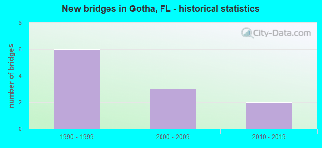
- New bridges - historical statistics
- 61990-1999
- 32000-2009
- 22010-2019


- Bridge Condition - Deck
- 33.3%Very good
- 66.7%Good

- Bridge Condition - Superstructure
- 33.3%Very good
- 66.7%Good

- Bridge Condition - Substructure
- 33.3%Very good
- 66.7%Good
Find on map >> Show street view
Structure Number: 750386, Location: 1.1MI WEST OF SR 50 (Lat: 28.534522, Lng: -81.529144), Route carried "on" structure: Ramp State highway 91, Year Built: 1990, Status: Open, Structure Length: 11.16m (36.61ft), Average Daily Traffic: 19,000 (year 2020), Truck Traffic: 21%, Average Future Daily Traffic: 32,965 (year 2042), Design Load: HS 20+Mod, Features Intersected: SR 408
Minimum Vertical Clearance: 30+ m (98+ ft), Kilometerpoint: 0.595, Lanes on structure: 2, Lanes under structure: 8, Toll: On toll road, Owner: State Toll Authority, Approaching Roadway Width: 12.4m (40.7ft), Skew: 9 degrees, Material/Design: Steel continuous, Design/Construction: Stringer/Multi-beam, Number Of Spans In Main Unit: 2, Length of Maximum Span: 61.0m (200.1ft), Curb-To-Curb Width: 12.4m (40.7ft), Out-to-Out Width: 13.1m (43.0ft)
Condition: Deck: Good, Superstructure: Good, Substructure: Good, Operating Rating: 29.8 metric tons, Method Used To Determine Operating Rating: Load and Resistance Factor (LRFR), Inventory Rating: 23.0 metric tons, Method Used To Determine Inventory Rating: Load and Resistance Factor (LRFR), Structural Evaluation: Somewhat better than minimum adequacy, Deck Geometry: Superior to present desirable criteria, Underclear: Somewhat better than minimum adequacy, Approach Roadway Alignment: Equal to present desirable criteria, Designated Inspection Frequency: Every 24 months, Inspection Date: October 2021, Deck Structure Type: Concrete Cast-file-Place
Find on map >> Show street view
Structure Number: 750387, Location: 0.6 MI E OF SR 91 TPK (Lat: 28.539575, Lng: -81.522908), Route carried "on" structure: County highway , Year Built: 1990, Status: Open, Structure Length: 6.61m (21.69ft), Average Daily Traffic: 5,100 (year 2020), Truck Traffic: 6%, Average Future Daily Traffic: 8,849 (year 2042), Design Load: HS 20, Features Intersected: SR 408 EW EXPRESSWAY, Facility Carried by Structure: HEMPEL AVE 0.3
Minimum Vertical Clearance: 30+ m (98+ ft), Kilometerpoint: 3.600, Lanes on structure: 2, Lanes under structure: 5, Owner: State Toll Authority, Approaching Roadway Width: 8.7m (28.5ft), Skew: 4 degrees, Material/Design: Prestressed concrete, Design/Construction: Stringer/Multi-beam, Number Of Spans In Main Unit: 2, Length of Maximum Span: 33.1m (108.6ft), Curb or Sidewalk Widths: Left: 1.3m (4.3ft), Right: 1.5m (4.9ft), Curb-To-Curb Width: 8.7m (28.5ft), Out-to-Out Width: 13.3m (43.6ft)
Condition: Deck: Good, Superstructure: Good, Substructure: Good, Operating Rating: 55.5 metric tons, Method Used To Determine Operating Rating: Load and Resistance Factor (LRFR), Inventory Rating: 32.3 metric tons, Method Used To Determine Inventory Rating: Load and Resistance Factor (LRFR), Structural Evaluation: Better than present minimum criteria, Deck Geometry: Meets minimum limits, Underclear: Equal to present minimum criteria, Approach Roadway Alignment: Equal to present desirable criteria, Designated Inspection Frequency: Every 24 months, Inspection Date: November 2021, Deck Structure Type: Concrete Cast-file-Place
Find on map >> Show street view
Structure Number: 750389, Location: 0.6 MI S OF SR 50 (Lat: 28.543922, Lng: -81.516181), Route carried "on" structure: Ramp State highway 50, Year Built: 1990, Status: Open, Structure Length: 8.47m (27.79ft), Average Daily Traffic: 5,500 (year 2020), Truck Traffic: 7%, Average Future Daily Traffic: 9,542 (year 2042), Design Load: HS 20, Features Intersected: SR 408 EW EXPRESSWAY
Minimum Vertical Clearance: 30+ m (98+ ft), Kilometerpoint: 0.959, Lanes on structure: 2, Lanes under structure: 4, Owner: State Toll Authority, Approaching Roadway Width: 12.3m (40.4ft), Skew: 4 degrees, Material/Design: Steel continuous, Design/Construction: Stringer/Multi-beam, Number Of Spans In Main Unit: 2, Length of Maximum Span: 50.3m (165.0ft), Curb-To-Curb Width: 12.3m (40.4ft), Out-to-Out Width: 13.2m (43.3ft)
Condition: Deck: Good, Superstructure: Good, Substructure: Good, Operating Rating: 30.2 metric tons, Method Used To Determine Operating Rating: Load and Resistance Factor (LRFR), Inventory Rating: 23.3 metric tons, Method Used To Determine Inventory Rating: Load and Resistance Factor (LRFR), Structural Evaluation: Somewhat better than minimum adequacy, Deck Geometry: Superior to present desirable criteria, Underclear: Somewhat better than minimum adequacy, Approach Roadway Alignment: Equal to present desirable criteria, Designated Inspection Frequency: Every 24 months, Inspection Date: November 2021, Deck Structure Type: Concrete Cast-file-Place
Find on map >> Show street view
Structure Number: 750627, Location: 1.6MI N OF SERVICE PLAZA (Lat: 28.531050, Lng: -81.522831), Route carried "on" structure: State highway 91, Year Built: 2006, Status: Open, Structure Length: 2.35m (7.71ft), Average Daily Traffic: 97,000 (year 2020), Truck Traffic: 21%, Average Future Daily Traffic: 168,295 (year 2042), Design Load: HL 93, Features Intersected: HEMPLE AVENUE
Minimum Vertical Clearance: 30+ m (98+ ft), Kilometerpoint: 26.100, Lanes on structure: 9, Lanes under structure: 2, Base Highway Network: Yes, Toll: On toll road, Owner: State Toll Authority, Approaching Roadway Width: 46.3m (151.9ft), Skew: 33 degrees, Material/Design: Prestressed concrete, Design/Construction: Stringer/Multi-beam, Number Of Spans In Main Unit: 1, Length of Maximum Span: 23.5m (77.1ft), Curb-To-Curb Width: 46.3m (151.9ft), Out-to-Out Width: 47.9m (157.2ft)
Condition: Deck: Very good, Superstructure: Very good, Substructure: Very good, Operating Rating: 57.2 metric tons, Method Used To Determine Operating Rating: Load Factor (LF), Inventory Rating: 45.1 metric tons, Method Used To Determine Inventory Rating: Load Factor (LF), Structural Evaluation: Equal to present desirable criteria, Deck Geometry: Superior to present desirable criteria, Underclear: High priority of corrective action, Approach Roadway Alignment: Equal to present desirable criteria, Designated Inspection Frequency: Every 24 months, Inspection Date: October 2021, Deck Structure Type: Concrete Cast-file-Place
Find on map >> Show street view
Structure Number: 754129, Location: 1.0 Mile South of CR-526 (Lat: 28.530175, Lng: -81.503969), Route carried "on" structure: County highway , Year Built: 2004, Status: Open, Structure Length: 15.67m (51.41ft), Average Daily Traffic: 34,000 (year 2021), Truck Traffic: 5%, Average Future Daily Traffic: 58,990 (year 2042), Design Load: HS 20, Features Intersected: Steer Lake, Facility Carried by Structure: Apopka-Vineland Rd
Minimum Vertical Clearance: 30+ m (98+ ft), Kilometerpoint: 4.076, Lanes on structure: 4, Owner: County Highway Agency, Approaching Roadway Width: 18.7m (61.4ft), Skew: 29 degrees, Material/Design: Prestressed concrete, Design/Construction: Stringer/Multi-beam, Number Of Spans In Main Unit: 7, Length of Maximum Span: 22.3m (73.2ft), Curb or Sidewalk Widths: Left: 1.7m (5.6ft), Right: 1.7m (5.6ft), Curb-To-Curb Width: 19.4m (63.6ft), Out-to-Out Width: 29.2m (95.8ft)
Condition: Deck: Very good, Superstructure: Very good, Substructure: Very good, Channel: Good, Operating Rating: 72.6 metric tons, Method Used To Determine Operating Rating: Load Factor (LF), Inventory Rating: 43.5 metric tons, Method Used To Determine Inventory Rating: Load Factor (LF), Structural Evaluation: Equal to present desirable criteria, Deck Geometry: Better than present minimum criteria, Waterway Adequacy: Superior to present desirable criteria, Approach Roadway Alignment: Equal to present desirable criteria, Designated Inspection Frequency: Every 24 months, Underwater Inspection Frequency: Every 24 months, Inspection Date: July 2021, Underwater Inspection Date: July 2021, Deck Structure Type: Concrete Cast-file-Place
Find on map >> Show street view
Structure Number: 754147, Location: 2.7 MI N OF HIAWASSEE RD (Lat: 28.527700, Lng: -81.516928), Route carried "on" structure: County highway , Year Built: 2010, Status: Open, Structure Length: 10.49m (34.42ft), Average Daily Traffic: 107,000 (year 2016), Truck Traffic: 17%, Average Future Daily Traffic: 185,645 (year 2038), Design Load: HL 93, Features Intersected: SR 91 TPK, Facility Carried by Structure: Gotha Rd 265.2
Minimum Vertical Clearance: 30.45m (99.90ft), Kilometerpoint: 0.000, Lanes on structure: 2, Lanes under structure: 8, Owner: State Toll Authority, Approaching Roadway Width: 12.2m (40.0ft), Skew: 5 degrees, Material/Design: Steel, Design/Construction: Stringer/Multi-beam, Number Of Spans In Main Unit: 2, Length of Maximum Span: 52.4m (171.9ft), Curb or Sidewalk Widths: Left: 1.5m (4.9ft), Right: 1.5m (4.9ft), Curb-To-Curb Width: 12.2m (40.0ft), Out-to-Out Width: 16.8m (55.1ft)
Condition: Deck: Good, Superstructure: Good, Substructure: Good, Operating Rating: 51.0 metric tons, Method Used To Determine Operating Rating: Load and Resistance Factor (LRFR), Inventory Rating: 39.2 metric tons, Method Used To Determine Inventory Rating: Load and Resistance Factor (LRFR), Structural Evaluation: Better than present minimum criteria, Deck Geometry: Somewhat better than minimum adequacy, Underclear: Equal to present minimum criteria, Approach Roadway Alignment: Equal to present desirable criteria, Designated Inspection Frequency: Every 24 months, Inspection Date: October 2021, Deck Structure Type: Concrete Cast-file-Place
Find on map >> Show street view
Structure Number: 750386, Location: 1.1MI WEST OF SR 50 (Lat: 28.534522, Lng: -81.529144), Route carried "under" structure: State highway 91, Year Built: 1990, Structure Length: 0. m, Average Daily Traffic: 135,200 (year 2020), Truck Traffic: 21%, Features Intersected: SR 408
Minimum Vertical Clearance: 4.82m (15.81ft), Kilometerpoint: 26.807, Lanes on structure: 2, Lanes under structure: 8, Toll: On toll road, Material/Design: Steel continuous, Design/Construction: Stringer/Multi-beam, Length of Maximum Span: 61.0m (200.1ft)
Find on map >> Show street view
Structure Number: 750387, Location: 0.6 MI E OF SR 91 TPK (Lat: 28.539575, Lng: -81.522908), Route carried "under" structure: State highway 408, Year Built: 1990, Structure Length: 0. m, Average Daily Traffic: 53,400 (year 2020), Truck Traffic: 12%, Features Intersected: SR 408 EW EXPRESSWAY, Facility Carried by Structure: HEMPEL AVE 0.3
Minimum Vertical Clearance: 5.23m (17.16ft), Kilometerpoint: 0.529, Lanes on structure: 2, Lanes under structure: 5, Toll: On toll road, Material/Design: Prestressed concrete, Design/Construction: Stringer/Multi-beam, Length of Maximum Span: 33.1m (108.6ft)
Find on map >> Show street view
Structure Number: 750389, Location: 0.6 MI S OF SR 50 (Lat: 28.543922, Lng: -81.516181), Route carried "under" structure: State highway 408, Year Built: 1990, Structure Length: 0. m, Average Daily Traffic: 80,500 (year 2020), Truck Traffic: 6%, Features Intersected: SR 408 EW EXPRESSWAY, Facility Carried by Structure: SR 50 CNNCTR 1.5
Minimum Vertical Clearance: 4.98m (16.34ft), Kilometerpoint: 2.422, Lanes on structure: 2, Lanes under structure: 4, Toll: On toll road, Material/Design: Steel continuous, Design/Construction: Stringer/Multi-beam, Length of Maximum Span: 50.3m (165.0ft)
Find on map >> Show street view
Structure Number: 750627, Location: 1.6MI N OF SERVICE PLAZA (Lat: 28.531050, Lng: -81.522831), Route carried "under" structure: County highway , Year Built: 2006, Structure Length: 0. m, Average Daily Traffic: 97,000 (year 2020), Truck Traffic: 21%, Features Intersected: HEMPLE AVENUE, Facility Carried by Structure: SR 91 TPK NS 265.7
Minimum Vertical Clearance: 5.28m (17.32ft), Kilometerpoint: 26.087, Lanes on structure: 9, Lanes under structure: 2, Material/Design: Prestressed concrete, Design/Construction: Stringer/Multi-beam, Length of Maximum Span: 23.5m (77.1ft)
Find on map >> Show street view
Structure Number: 754147, Location: 2.7 MI N OF HIAWASSEE RD (Lat: 28.527700, Lng: -81.516928), Route carried "under" structure: State highway 91, Year Built: 2010, Structure Length: 0. m, Average Daily Traffic: 97,000 (year 2020), Truck Traffic: 21%, Features Intersected: SR 91 TPK, Facility Carried by Structure: Gotha Rd 265.2
Minimum Vertical Clearance: 5.03m (16.50ft), Kilometerpoint: 25.395, Lanes on structure: 2, Lanes under structure: 8, Toll: On toll road, Material/Design: Steel, Design/Construction: Stringer/Multi-beam, Length of Maximum Span: 52.4m (171.9ft)