Bridge Statistics for Gouglersville, Pennsylvania (PA)
Condition, Traffic, Stress, Structural Evaluation, Project Costs
- National Bridge Inventory (NBI) Statistics
- 14Number of bridges
- 82ft / 24.5mTotal length
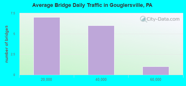
- 211,181Total average daily traffic
- 19,625Total average daily truck traffic
- National Bridge Inventory (NBI) Registered Bridges for Gouglersville
- No street view available for this location
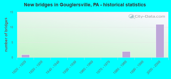
- New bridges - historical statistics
- 11920-1929
- 21980-1989
- 112000-2009
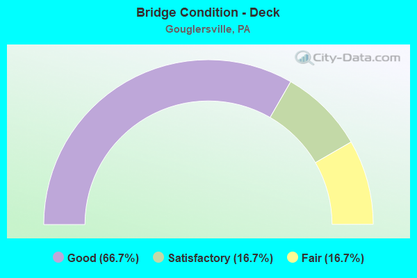
- Bridge Condition - Deck
- 66.7%Good
- 16.7%Satisfactory
- 16.7%Fair
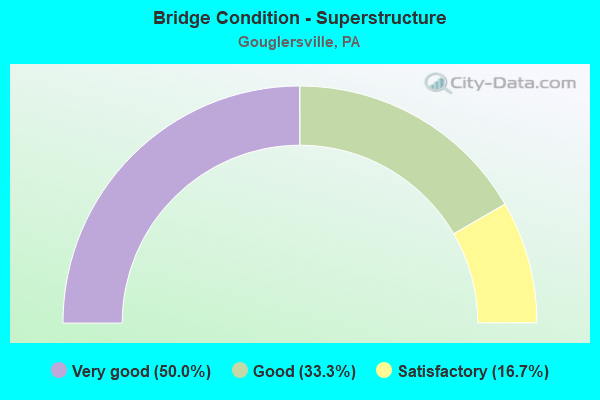
- Bridge Condition - Superstructure
- 50.0%Very good
- 33.3%Good
- 16.7%Satisfactory
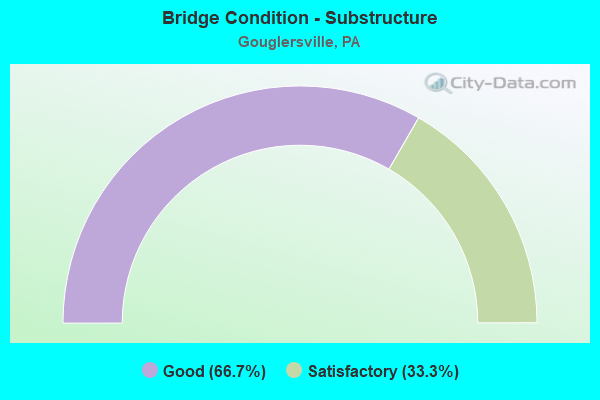
- Bridge Condition - Substructure
- 66.7%Good
- 33.3%Satisfactory
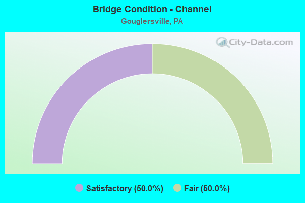
- Bridge Condition - Channel
- 50.0%Satisfactory
- 50.0%Fair
Find on map >> Show street view
Structure Number: 5158, Location: VERMONT&WYOMISSING RDS. (Lat: 40.272828, Lng: -76.001086), Route carried "on" structure: State highway , Year Built: 1985, Status: Open, Structure Length: 0.94m (3.08ft), Average Daily Traffic: 943 (year 2022), Truck Traffic: 3%, Average Future Daily Traffic: 1,932 (year 2032), Design Load: HS 20+Mod, Features Intersected: WYOMISSING CREEK, Facility Carried by Structure: SR 3018 (LR 660)
Minimum Vertical Clearance: 30+ m (98+ ft), Kilometerpoint: 1.891, Lanes on structure: 2, Owner: State Highway Agency, Approaching Roadway Width: 9.8m (32.2ft), Material/Design: Prestressed concrete, Design/Construction: Slab, Number Of Spans In Main Unit: 1, Length of Maximum Span: 8.2m (26.9ft), Curb or Sidewalk Widths: Left: 0.2m (0.7ft), Right: 0.2m (0.7ft), Curb-To-Curb Width: 9.6m (31.5ft), Out-to-Out Width: 10.6m (34.8ft)
Condition: Deck: Good, Superstructure: Very good, Substructure: Good, Channel: Fair, Operating Rating: 89.8 metric tons, Method Used To Determine Operating Rating: Load Factor (LF), Inventory Rating: 51.7 metric tons, Method Used To Determine Inventory Rating: Load Factor (LF), Structural Evaluation: Better than present minimum criteria, Deck Geometry: Equal to present minimum criteria, Waterway Adequacy: Equal to present desirable criteria, Approach Roadway Alignment: Equal to present desirable criteria, Length Of Structure Improvement: 1.60m (5.25ft), Designated Inspection Frequency: Every 48 months, Inspection Date: June 2020, Wearing Surface/Protective System: Wearing Surface: Monolithic Concrete, Deck Protection: Epoxy Coated Reinforcing
Find on map >> Show street view
Structure Number: 546, Location: 1 MI.S.OF GOUGLERSVILLE (Lat: 40.259181, Lng: -76.037531), Route carried "on" structure: City street , Year Built: 1921, Status: Open, Structure Length: 1.10m (3.61ft), Average Daily Traffic: 440 (year 1977), Truck Traffic: 3%, Average Future Daily Traffic: 616 (year 2007), Features Intersected: LITTLE MUDDY CREEK, Facility Carried by Structure: T-597,OLD LANC.PIK
Minimum Vertical Clearance: 30+ m (98+ ft), Kilometerpoint: 0.000, Lanes on structure: 2, Owner: Town or Township Highway Agency, Approaching Roadway Width: 5.5m (18.0ft), Skew: 3 degrees, Material/Design: Concrete, Design/Construction: Tee Beam, Number Of Spans In Main Unit: 1, Length of Maximum Span: 9.8m (32.2ft), Curb-To-Curb Width: 7.1m (23.3ft), Out-to-Out Width: 7.9m (25.9ft)
Condition: Deck: Fair, Superstructure: Satisfactory, Substructure: Satisfactory, Channel: Satisfactory, Operating Rating: 39.0 metric tons, Method Used To Determine Operating Rating: Load Factor (LF), Inventory Rating: 22.7 metric tons, Method Used To Determine Inventory Rating: Load Factor (LF), Structural Evaluation: Equal to present minimum criteria, Deck Geometry: Meets minimum limits, Waterway Adequacy: Equal to present minimum criteria, Approach Roadway Alignment: Better than present minimum criteria, Length Of Structure Improvement: 1.70m (5.58ft), Designated Inspection Frequency: Every 24 months, Inspection Date: October 2021, Deck Structure Type: Concrete Cast-file-Place, Wearing Surface/Protective System: Wearing Surface: Bituminous
Find on map >> Show street view
Structure Number: 43489, Location: US 222 OVER L.MUDDY CR. (Lat: 40.255950, Lng: -76.034481), Route carried "on" structure: US 222, Year Built: 2004, Status: Open, Structure Length: 2.01m (6.59ft), Average Daily Traffic: 55,295 (year 2022), Truck Traffic: 10%, Average Future Daily Traffic: 59,704 (year 2037), Design Load: HL 93, Features Intersected: LITTLE MUDDY CREEK
Minimum Vertical Clearance: 30+ m (98+ ft), Kilometerpoint: 1.445, Lanes on structure: 2, Base Highway Network: Yes, Owner: State Highway Agency, Approaching Roadway Width: 11.0m (36.1ft), Skew: 30 degrees, Material/Design: Prestressed concrete, Design/Construction: Box Beam or Girders - Single/Spread, Number Of Spans In Main Unit: 1, Length of Maximum Span: 19.8m (65.0ft), Curb-To-Curb Width: 24.0m (78.7ft), Out-to-Out Width: 25.8m (84.6ft)
Condition: Deck: Good, Superstructure: Very good, Substructure: Good, Channel: Satisfactory, Operating Rating: 58.3 metric tons, Method Used To Determine Operating Rating: Assigned ratings based on Load and Resistance Factor Design (LRFD) reported by rating factor (RF) using HL93 loadings, Inventory Rating: 35.6 metric tons, Method Used To Determine Inventory Rating: Assigned ratings based on Load and Resistance Factor Design (LRFD) reported by rating factor (RF) using HL93 loadings, Structural Evaluation: Better than present minimum criteria, Deck Geometry: Superior to present desirable criteria, Waterway Adequacy: Superior to present desirable criteria, Approach Roadway Alignment: Equal to present desirable criteria, Designated Inspection Frequency: Every 48 months, Inspection Date: October 2018, Deck Structure Type: Concrete Cast-file-Place, Wearing Surface/Protective System: Wearing Surface: Monolithic Concrete, Deck Protection: Epoxy Coated Reinforcing
Find on map >> Show street view
Structure Number: 43491, Location: SR 3018 OVER US 222 (Lat: 40.273694, Lng: -76.022697), Route carried "on" structure: State highway , Year Built: 2004, Status: Open, Structure Length: 3.20m (10.50ft), Average Daily Traffic: 943 (year 2022), Truck Traffic: 3%, Average Future Daily Traffic: 1,932 (year 2032), Design Load: HL 93, Features Intersected: US 222, Facility Carried by Structure: SR 3018
Minimum Vertical Clearance: 30+ m (98+ ft), Kilometerpoint: 0.000, Lanes on structure: 2, Lanes under structure: 4, Owner: State Highway Agency, Approaching Roadway Width: 16.8m (55.1ft), Skew: 3 degrees, Material/Design: Prestressed concrete, Design/Construction: Box Beam or Girders - Single/Spread, Number Of Spans In Main Unit: 1, Length of Maximum Span: 32.0m (105.0ft), Curb or Sidewalk Widths: Left: 1.5m (4.9ft), Right: 1.5m (4.9ft), Curb-To-Curb Width: 16.8m (55.1ft), Out-to-Out Width: 19.8m (65.0ft)
Condition: Deck: Good, Superstructure: Good, Substructure: Good, Operating Rating: 94.3 metric tons, Method Used To Determine Operating Rating: Load and Resistance Factor (LRFR), Inventory Rating: 47.2 metric tons, Method Used To Determine Inventory Rating: Load and Resistance Factor (LRFR), Structural Evaluation: Better than present minimum criteria, Deck Geometry: Superior to present desirable criteria, Underclear: Meets minimum limits, Approach Roadway Alignment: Equal to present desirable criteria, Designated Inspection Frequency: Every 48 months, Inspection Date: September 2018, Deck Structure Type: Concrete Cast-file-Place, Wearing Surface/Protective System: Wearing Surface: Monolithic Concrete, Deck Protection: Epoxy Coated Reinforcing
Find on map >> Show street view
Structure Number: 43525, Location: T-597/SR 222&GRIZZLY RD (Lat: 40.266869, Lng: -76.031786), Route carried "on" structure: State highway , Year Built: 2004, Status: Open, Structure Length: 7.50m (24.61ft), Average Daily Traffic: 517 (year 2022), Truck Traffic: 3%, Average Future Daily Traffic: 1,660 (year 2032), Design Load: HL 93, Features Intersected: SR 222;GRIZZLY RD., Facility Carried by Structure: T-597
Minimum Vertical Clearance: 30+ m (98+ ft), Kilometerpoint: 0.000, Lanes on structure: 2, Lanes under structure: 6, Base Highway Network: Yes, Owner: State Highway Agency, Approaching Roadway Width: 11.9m (39.0ft), Skew: 4 degrees, Material/Design: Prestressed concrete continuous, Design/Construction: Stringer/Multi-beam, Number Of Spans In Main Unit: 2, Length of Maximum Span: 37.5m (123.0ft), Curb-To-Curb Width: 12.0m (39.4ft), Out-to-Out Width: 12.9m (42.3ft)
Condition: Deck: Good, Superstructure: Very good, Substructure: Good, Operating Rating: 68.9 metric tons, Method Used To Determine Operating Rating: Load and Resistance Factor (LRFR), Inventory Rating: 53.5 metric tons, Method Used To Determine Inventory Rating: Load and Resistance Factor (LRFR), Structural Evaluation: Better than present minimum criteria, Deck Geometry: Better than present minimum criteria, Underclear: High priority of corrective action, Approach Roadway Alignment: Better than present minimum criteria, Designated Inspection Frequency: Every 24 months, Inspection Date: September 2020, Deck Structure Type: Concrete Cast-file-Place, Wearing Surface/Protective System: Wearing Surface: Monolithic Concrete, Deck Protection: Epoxy Coated Reinforcing
Find on map >> Show street view
Structure Number: 43532, Location: T592 OVER SR222&GOOSE LN (Lat: 40.285522, Lng: -76.014733), Route carried "on" structure: State highway , Year Built: 2005, Status: Open, Structure Length: 9.11m (29.89ft), Average Daily Traffic: 1,322 (year 2022), Truck Traffic: 2%, Average Future Daily Traffic: 1,647 (year 2032), Design Load: HL 93, Features Intersected: SR 222;T385 GOOSE LANE, Facility Carried by Structure: T592 OLD LANC.PIKE
Minimum Vertical Clearance: 30+ m (98+ ft), Kilometerpoint: 0.000, Lanes on structure: 2, Lanes under structure: 7, Base Highway Network: Yes, Owner: State Highway Agency, Approaching Roadway Width: 11.9m (39.0ft), Skew: 5 degrees, Material/Design: Prestressed concrete continuous, Design/Construction: Stringer/Multi-beam, Number Of Spans In Main Unit: 3, Length of Maximum Span: 32.0m (105.0ft), Curb or Sidewalk Widths: Left: 1.5m (4.9ft), Right: 0.0m, Curb-To-Curb Width: 12.0m (39.4ft), Out-to-Out Width: 14.3m (46.9ft)
Condition: Deck: Satisfactory, Superstructure: Good, Substructure: Satisfactory, Operating Rating: 71.7 metric tons, Method Used To Determine Operating Rating: Load and Resistance Factor (LRFR), Inventory Rating: 39.0 metric tons, Method Used To Determine Inventory Rating: Load and Resistance Factor (LRFR), Structural Evaluation: Equal to present minimum criteria, Deck Geometry: Equal to present minimum criteria, Underclear: Meets minimum limits, Approach Roadway Alignment: Equal to present desirable criteria, Designated Inspection Frequency: Every 48 months, Inspection Date: October 2018, Deck Structure Type: Concrete Cast-file-Place, Wearing Surface/Protective System: Wearing Surface: Monolithic Concrete, Deck Protection: Epoxy Coated Reinforcing
Find on map >> Show street view
Structure Number: 47963, Location: SE OF GOUGLERSVILLE (Lat: 40.263356, Lng: -75.994467), Route carried "on" structure: City street , Year Built: 1987, Status: Open, Structure Length: 0.64m (2.10ft), Average Daily Traffic: 50 (year 2013), Truck Traffic: 1%, Average Future Daily Traffic: 75 (year 2023), Design Load: HS 20, Features Intersected: WYOMISSING CREEK, Facility Carried by Structure: HUNTERS ROAD
Minimum Vertical Clearance: 30+ m (98+ ft), Kilometerpoint: 0.000, Lanes on structure: 2, Owner: Town or Township Highway Agency, Approaching Roadway Width: 6.1m (20.0ft), Material/Design: Aluminum, Iron, Design/Construction: Culvert, Number Of Spans In Main Unit: 1, Length of Maximum Span: 6.4m (21.0ft)
Condition: Channel: Fair, Culverts: Satisfactory, Operating Rating: 54.4 metric tons, Method Used To Determine Operating Rating: Field evaluation and documented engineering judgment, Inventory Rating: 32.7 metric tons, Method Used To Determine Inventory Rating: Field evaluation and documented engineering judgment, Structural Evaluation: Equal to present minimum criteria, Waterway Adequacy: Superior to present desirable criteria, Approach Roadway Alignment: Equal to present desirable criteria, Designated Inspection Frequency: Every 24 months, Inspection Date: November 2021
Find on map >> Show street view
Structure Number: 43491, Location: SR 3018 OVER US 222 (Lat: 40.273694, Lng: -76.022697), Route carried "under" structure: US 222, Year Built: 2004, Structure Length: 0. m, Average Daily Traffic: 23,673 (year 2022), Truck Traffic: 8%, Features Intersected: US 222, Facility Carried by Structure: SR 3018
Minimum Vertical Clearance: 5.92m (19.42ft), Kilometerpoint: 3.764, Lanes on structure: 2, Lanes under structure: 2, Material/Design: Prestressed concrete, Design/Construction: Box Beam or Girders - Single/Spread, Length of Maximum Span: 32.0m (105.0ft)
Find on map >> Show street view
Structure Number: 43491, Location: SR 3018 OVER US 222 (Lat: 40.273694, Lng: -76.022697), Route carried "under" structure: US 222, Year Built: 2004, Structure Length: 0. m, Average Daily Traffic: 24,415 (year 2022), Truck Traffic: 9%, Features Intersected: US 222, Facility Carried by Structure: SR 3018
Minimum Vertical Clearance: 6.55m (21.49ft), Kilometerpoint: 3.747, Lanes on structure: 2, Lanes under structure: 2, Material/Design: Prestressed concrete, Design/Construction: Box Beam or Girders - Single/Spread, Length of Maximum Span: 32.0m (105.0ft)
Find on map >> Show street view
Structure Number: 43525, Location: T-597/SR 222&GRIZZLY RD (Lat: 40.266869, Lng: -76.031786), Route carried "under" structure: US 222, Year Built: 2004, Structure Length: 0. m, Average Daily Traffic: 27,576 (year 2022), Truck Traffic: 11%, Features Intersected: SR 222;GRIZZLY RD., Facility Carried by Structure: T-597
Minimum Vertical Clearance: 5.61m (18.41ft), Kilometerpoint: 2.681, Lanes on structure: 2, Lanes under structure: 2, Material/Design: Prestressed concrete continuous, Design/Construction: Stringer/Multi-beam, Length of Maximum Span: 37.5m (123.0ft)
Find on map >> Show street view
Structure Number: 43525, Location: T-597/SR 222&GRIZZLY RD (Lat: 40.266869, Lng: -76.031786), Route carried "under" structure: US 222, Year Built: 2004, Structure Length: 0. m, Average Daily Traffic: 27,719 (year 2022), Truck Traffic: 10%, Features Intersected: SR 222;GRIZZLY RD., Facility Carried by Structure: T-597
Minimum Vertical Clearance: 6.77m (22.21ft), Kilometerpoint: 2.704, Lanes on structure: 2, Lanes under structure: 2, Material/Design: Prestressed concrete continuous, Design/Construction: Stringer/Multi-beam, Length of Maximum Span: 37.5m (123.0ft)
Find on map >> Show street view
Structure Number: 43525, Location: T-597/SR 222&GRIZZLY RD (Lat: 40.266869, Lng: -76.031786), Route carried "under" structure: City street , Year Built: 2004, Structure Length: 0. m, Average Daily Traffic: 200 (year 2006), Truck Traffic: 1%, Features Intersected: SR 222;GRIZZLY RD., Facility Carried by Structure: T-597
Minimum Vertical Clearance: 4.79m (15.72ft), Kilometerpoint: 0.000, Lanes on structure: 2, Lanes under structure: 2, Material/Design: Prestressed concrete continuous, Design/Construction: Stringer/Multi-beam, Length of Maximum Span: 37.5m (123.0ft)
Find on map >> Show street view
Structure Number: 43532, Location: T592 OVER SR222&GOOSE LN (Lat: 40.285522, Lng: -76.014733), Route carried "under" structure: US 222, Year Built: 2005, Structure Length: 0. m, Average Daily Traffic: 24,415 (year 2022), Truck Traffic: 9%, Features Intersected: SR 222;T385 GOOSE LANE, Facility Carried by Structure: T592 OLD LANC.PIKE
Minimum Vertical Clearance: 5.49m (18.01ft), Kilometerpoint: 5.274, Lanes on structure: 2, Lanes under structure: 2, Material/Design: Prestressed concrete continuous, Design/Construction: Stringer/Multi-beam, Length of Maximum Span: 32.0m (105.0ft)
Find on map >> Show street view
Structure Number: 43532, Location: T592 OVER SR222&GOOSE LN (Lat: 40.285522, Lng: -76.014733), Route carried "under" structure: US 222, Year Built: 2005, Structure Length: 0. m, Average Daily Traffic: 23,673 (year 2022), Truck Traffic: 8%, Features Intersected: SR 222;T385 GOOSE LANE, Facility Carried by Structure: T592 OLD LANC.PIKE
Minimum Vertical Clearance: 5.12m (16.80ft), Kilometerpoint: 5.258, Lanes on structure: 2, Lanes under structure: 3, Material/Design: Prestressed concrete continuous, Design/Construction: Stringer/Multi-beam, Length of Maximum Span: 32.0m (105.0ft)