Bridge Statistics for Grand Coteau, Louisiana (LA)
Condition, Traffic, Stress, Structural Evaluation, Project Costs
- National Bridge Inventory (NBI) Statistics
- 10Number of bridges
- 102ft / 31.2mTotal length
- 71,330Total average daily traffic
- 11,311Total average daily truck traffic
- National Bridge Inventory (NBI) Registered Bridges for Grand Coteau
- No street view available for this location
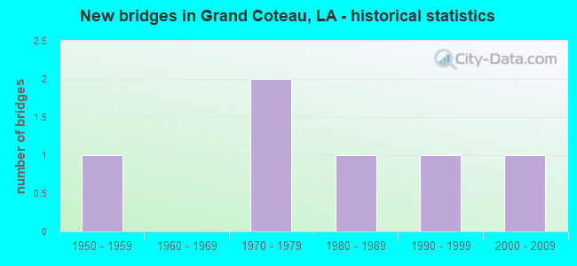
- New bridges - historical statistics
- 11950-1959
- 21970-1979
- 11980-1989
- 11990-1999
- 12000-2009


- Bridge Condition - Deck
- 16.7%Very good
- 66.7%Good
- 16.7%Satisfactory

- Bridge Condition - Superstructure
- 16.7%Very good
- 66.7%Good
- 16.7%Satisfactory

- Bridge Condition - Substructure
- 16.7%Very good
- 66.7%Good
- 16.7%Satisfactory

- Bridge Condition - Channel
- 50.0%Very good
- 50.0%Good
Find on map >> Show street view
Structure Number: 34902210104711, Location: 2.9 MI WEST OF LA 760-2 (Lat: 30.405300, Lng: -91.994400), Route carried "on" structure: State highway 93, Year Built: 1959, Status: Open, Structure Length: 5.49m (18.01ft), Average Daily Traffic: 4,300 (year 2016), Truck Traffic: 13%, Average Future Daily Traffic: 5,330 (year 2036), Design Load: HS 20, Features Intersected: BAYOU BOURBEAU
Minimum Vertical Clearance: 30+ m (98+ ft), Kilometerpoint: 7.553, Lanes on structure: 2, Base Highway Network: Yes (Inventory Route: 221-01-1, Subroute: 10), Owner: State Highway Agency, Approaching Roadway Width: 14.0m (45.9ft), Material/Design: Concrete, Design/Construction: Slab, Number Of Spans In Main Unit: 9, Length of Maximum Span: 6.1m (20.0ft), Curb-To-Curb Width: 8.5m (27.9ft), Out-to-Out Width: 10.3m (33.8ft)
Condition: Deck: Satisfactory, Superstructure: Satisfactory, Substructure: Satisfactory, Channel: Good, Operating Rating: 38.1 metric tons, Method Used To Determine Operating Rating: Load Factor (LF), Inventory Rating: 22.7 metric tons, Method Used To Determine Inventory Rating: Load Factor (LF), Structural Evaluation: Equal to present minimum criteria, Deck Geometry: Meets minimum limits, Waterway Adequacy: Equal to present minimum criteria, Approach Roadway Alignment: Equal to present desirable criteria, Designated Inspection Frequency: Every 24 months, Inspection Date: May 2021, Deck Structure Type: Concrete Cast-file-Place
Find on map >> Show street view
Structure Number: 34904550202591, Location: I-49 OVER LA 93 (Lat: 30.415931, Lng: -92.054100), Route carried "on" structure: Interstate 49, Year Built: 1978, Status: Open, Structure Length: 8.44m (27.69ft), Average Daily Traffic: 19,200 (year 2016), Truck Traffic: 28%, Average Future Daily Traffic: 29,406 (year 2036), Design Load: HS 20, Features Intersected: LA0093
Minimum Vertical Clearance: 30+ m (98+ ft), Kilometerpoint: 4.215, Lanes on structure: 2, Lanes under structure: 4, Base Highway Network: Yes (Inventory Route: 455-02-1, Subroute: 10), Owner: State Highway Agency, Approaching Roadway Width: 13.4m (44.0ft), Skew: 34 degrees, Material/Design: Prestressed concrete, Design/Construction: Stringer/Multi-beam, Number Of Spans In Main Unit: 2, Number Of Approach Spans: 2, Length of Maximum Span: 24.1m (79.1ft), Curb-To-Curb Width: 13.0m (42.7ft), Out-to-Out Width: 13.9m (45.6ft)
Condition: Deck: Good, Superstructure: Good, Substructure: Good, Operating Rating: 89.8 metric tons, Method Used To Determine Operating Rating: Load Factor (LF), Inventory Rating: 35.4 metric tons, Method Used To Determine Inventory Rating: Load Factor (LF), Structural Evaluation: Better than present minimum criteria, Deck Geometry: Superior to present desirable criteria, Underclear: Meets minimum limits, Approach Roadway Alignment: Equal to present desirable criteria, Designated Inspection Frequency: Every 24 months, Inspection Date: May 2020, Deck Structure Type: Concrete Cast-file-Place
Find on map >> Show street view
Structure Number: 34904550202592, Location: I-49 OVER LA 93 (Lat: 30.416600, Lng: -92.054200), Route carried "on" structure: Interstate 49, Year Built: 1978, Status: Open, Structure Length: 8.53m (27.99ft), Average Daily Traffic: 19,200 (year 2016), Truck Traffic: 28%, Average Future Daily Traffic: 29,406 (year 2036), Design Load: HS 20, Features Intersected: LA0093
Minimum Vertical Clearance: 30+ m (98+ ft), Kilometerpoint: 44.408, Lanes on structure: 2, Lanes under structure: 4, Base Highway Network: Yes (Inventory Route: 455-02-2, Subroute: 10), Owner: State Highway Agency, Approaching Roadway Width: 13.4m (44.0ft), Skew: 34 degrees, Material/Design: Prestressed concrete, Design/Construction: Stringer/Multi-beam, Number Of Spans In Main Unit: 2, Number Of Approach Spans: 2, Length of Maximum Span: 24.4m (80.1ft), Curb-To-Curb Width: 13.0m (42.7ft), Out-to-Out Width: 13.9m (45.6ft)
Condition: Deck: Good, Superstructure: Good, Substructure: Good, Operating Rating: 89.8 metric tons, Method Used To Determine Operating Rating: Load Factor (LF), Inventory Rating: 34.5 metric tons, Method Used To Determine Inventory Rating: Load Factor (LF), Structural Evaluation: Better than present minimum criteria, Deck Geometry: Superior to present desirable criteria, Underclear: Meets minimum limits, Approach Roadway Alignment: Equal to present desirable criteria, Designated Inspection Frequency: Every 24 months, Inspection Date: May 2020, Deck Structure Type: Concrete Cast-file-Place
Find on map >> Show street view
Structure Number: 34930228920081, Location: 2.40 Mi NW of LA 1252 (Lat: 30.380469, Lng: -92.013261), Route carried "on" structure: County highway , Year Built: 1987, Status: Open, Structure Length: 1.74m (5.71ft), Average Daily Traffic: 150 (year 2020), Average Future Daily Traffic: 165 (year 2040), Design Load: HS 20, Features Intersected: DRAINAGE BAYOU, Facility Carried by Structure: Odon Meche Rd.
Minimum Vertical Clearance: 30+ m (98+ ft), Kilometerpoint: 0.000, Lanes on structure: 2, Owner: County Highway Agency, Approaching Roadway Width: 9.4m (30.8ft), Material/Design: Concrete, Design/Construction: Slab, Number Of Spans In Main Unit: 3, Length of Maximum Span: 5.8m (19.0ft), Curb-To-Curb Width: 7.3m (24.0ft), Out-to-Out Width: 8.2m (26.9ft)
Condition: Deck: Good, Superstructure: Good, Substructure: Good, Channel: Very good, Operating Rating: 24.0 metric tons, Method Used To Determine Operating Rating: Load and Resistance Factor Rating (LRFR) rating reported by rating factor(RF) method using HL-93 loadings, Inventory Rating: 18.5 metric tons, Method Used To Determine Inventory Rating: Load and Resistance Factor Rating (LRFR) rating reported by rating factor(RF) method using HL-93 loadings, Structural Evaluation: Somewhat better than minimum adequacy, Deck Geometry: Somewhat better than minimum adequacy, Waterway Adequacy: Equal to present desirable criteria, Approach Roadway Alignment: Equal to present minimum criteria, Designated Inspection Frequency: Every 24 months, Inspection Date: April 2021, Deck Structure Type: Concrete Cast-file-Place
Find on map >> Show street view
Structure Number: 34930247915981, Location: 0.53 Mi N of LA 93 (Lat: 30.411889, Lng: -91.998411), Route carried "on" structure: County highway , Year Built: 1997, Status: Open, Structure Length: 4.57m (14.99ft), Average Daily Traffic: 400 (year 2020), Average Future Daily Traffic: 440 (year 2040), Design Load: HS 20, Features Intersected: BAYOU BOURBEUX, Facility Carried by Structure: Hickory Rd.
Minimum Vertical Clearance: 30+ m (98+ ft), Kilometerpoint: 0.000, Lanes on structure: 2, Base Highway Network: Yes, Owner: County Highway Agency, Approaching Roadway Width: 6.1m (20.0ft), Material/Design: Concrete, Design/Construction: Slab, Number Of Spans In Main Unit: 5, Length of Maximum Span: 9.1m (29.9ft), Curb-To-Curb Width: 7.3m (24.0ft), Out-to-Out Width: 7.9m (25.9ft)
Condition: Deck: Good, Superstructure: Good, Substructure: Very good, Channel: Very good, Operating Rating: 41.1 metric tons, Method Used To Determine Operating Rating: Load and Resistance Factor Rating (LRFR) rating reported by rating factor(RF) method using HL-93 loadings, Inventory Rating: 31.8 metric tons, Method Used To Determine Inventory Rating: Load and Resistance Factor Rating (LRFR) rating reported by rating factor(RF) method using HL-93 loadings, Structural Evaluation: Better than present minimum criteria, Deck Geometry: Somewhat better than minimum adequacy, Waterway Adequacy: Equal to present desirable criteria, Approach Roadway Alignment: Equal to present desirable criteria, Designated Inspection Frequency: Every 24 months, Inspection Date: April 2021, Deck Structure Type: Concrete Cast-file-Place
Find on map >> Show street view
Structure Number: 34930265920381, Location: 0.73 Mi SE of I-49 (Lat: 30.441089, Lng: -92.062319), Route carried "on" structure: County highway , Year Built: 2007, Status: Open, Structure Length: 2.44m (8.01ft), Average Daily Traffic: 80 (year 2020), Average Future Daily Traffic: 88 (year 2040), Design Load: HS 20, Features Intersected: Bourbeau Bayou Tributary, Facility Carried by Structure: Jack Fox Rd
Minimum Vertical Clearance: 30+ m (98+ ft), Kilometerpoint: 0.000, Lanes on structure: 2, Owner: County Highway Agency, Approaching Roadway Width: 3.7m (12.1ft), Material/Design: Concrete, Design/Construction: Slab, Number Of Spans In Main Unit: 4, Length of Maximum Span: 6.1m (20.0ft), Curb-To-Curb Width: 6.7m (22.0ft), Out-to-Out Width: 7.3m (24.0ft)
Condition: Deck: Very good, Superstructure: Very good, Substructure: Good, Channel: Good, Operating Rating: 51.5 metric tons, Method Used To Determine Operating Rating: Load and Resistance Factor Rating (LRFR) rating reported by rating factor(RF) method using HL-93 loadings, Inventory Rating: 39.9 metric tons, Method Used To Determine Inventory Rating: Load and Resistance Factor Rating (LRFR) rating reported by rating factor(RF) method using HL-93 loadings, Structural Evaluation: Better than present minimum criteria, Waterway Adequacy: Equal to present desirable criteria, Approach Roadway Alignment: High priority of corrective action, Designated Inspection Frequency: Every 24 months, Inspection Date: January 2021, Deck Structure Type: Concrete Precast Panels
Find on map >> Show street view
Structure Number: 34904550202591, Location: 0.5 MI N OF LA 182 (Lat: 30.416519, Lng: -92.053989), Route carried "under" structure: State highway 93, Structure Length: 0. m, Average Daily Traffic: 7,000 (year 2014), Features Intersected: LA 93 WB UNDER I-49 NB
Minimum Vertical Clearance: 5.21m (17.09ft), Kilometerpoint: 8.106, Lanes on structure: 2, Length of Maximum Span: 0.0m
Find on map >> Show street view
Structure Number: 34904550202591, Location: 0.5 MI N OF LA 182 (Lat: 30.416161, Lng: -92.054181), Route carried "under" structure: State highway 93, Structure Length: 0. m, Average Daily Traffic: 7,000 (year 2014), Features Intersected: LA 93 EB UNDER I-49 NB
Minimum Vertical Clearance: 5.24m (17.19ft), Kilometerpoint: 0.961, Lanes on structure: 2, Length of Maximum Span: 0.0m
Find on map >> Show street view
Structure Number: 34904550202592, Location: 0.5 MI N OF LA 182 (Lat: 30.416019, Lng: -92.054331), Route carried "under" structure: State highway 93, Structure Length: 0. m, Average Daily Traffic: 7,000 (year 2014), Features Intersected: LA 93 EB UNDER I-49 SB
Minimum Vertical Clearance: 4.54m (14.90ft), Kilometerpoint: 0.940, Lanes on structure: 2, Length of Maximum Span: 0.0m
Find on map >> Show street view
Structure Number: 34904550202592, Location: 0.5 MI N OF LA 182 (Lat: 30.416419, Lng: -92.054150), Route carried "under" structure: State highway 93, Structure Length: 0. m, Average Daily Traffic: 7,000 (year 2014), Features Intersected: LA 93 WB UNDER I-49 SB
Minimum Vertical Clearance: 4.72m (15.49ft), Kilometerpoint: 8.126, Lanes on structure: 2, Length of Maximum Span: 0.0m