Bridge Statistics for Grandview Plaza, Kansas (KS)
Condition, Traffic, Stress, Structural Evaluation, Project Costs
- National Bridge Inventory (NBI) Statistics
- 17Number of bridges
- 387ft / 118mTotal length
- $580,000Total costs
- 151,702Total average daily traffic
- 23,041Total average daily truck traffic
- National Bridge Inventory (NBI) Registered Bridges for Grandview Plaza
- No street view available for this location
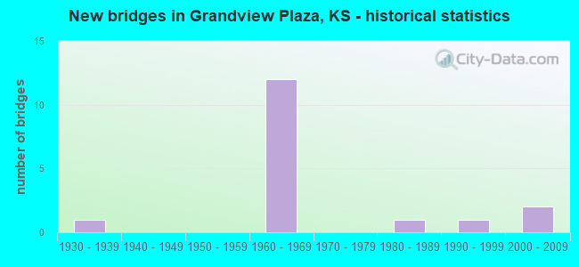
- New bridges - historical statistics
- 11930-1939
- 121960-1969
- 11980-1989
- 11990-1999
- 22000-2009

- Reconstructed bridges - Historical Statistics
- 41980-1989
- 21990-1999


- Bridge Condition - Deck
- 61.5%Good
- 30.8%Satisfactory
- 7.7%Poor

- Bridge Condition - Superstructure
- 15.4%Very good
- 61.5%Good
- 7.7%Satisfactory
- 15.4%Poor

- Bridge Condition - Substructure
- 15.4%Very good
- 46.2%Good
- 30.8%Satisfactory
- 7.7%Poor

- Bridge Condition - Channel
- 44.4%Good
- 33.3%Satisfactory
- 22.2%Fair
Find on map >> Show street view
Structure Number: 310016, Location: 4.8E OF JUNCTION CITY (Lat: 39.029444, Lng: -96.742778), Route carried "on" structure: County highway 1695, Year Built: 2001, Status: Open, Structure Length: 1.13m (3.71ft), Average Daily Traffic: 250 (year 2004), Truck Traffic: 10%, Average Future Daily Traffic: 265 (year 2039), Design Load: HS 20, Features Intersected: TRIB. OF CLARKS CREEK, Facility Carried by Structure: CLARKS CREEK ROAD
Minimum Vertical Clearance: 30.47m (99.97ft), Kilometerpoint: 5.472, Lanes on structure: 2, Owner: County Highway Agency, Approaching Roadway Width: 7.4m (24.3ft), Material/Design: Concrete, Design/Construction: Culvert, Number Of Spans In Main Unit: 3, Length of Maximum Span: 3.7m (12.1ft), Curb-To-Curb Width: 13.1m (43.0ft), Out-to-Out Width: 13.6m (44.6ft)
Condition: Channel: Satisfactory, Culverts: Very good, Operating Rating: 74.7 metric tons, Method Used To Determine Operating Rating: Load Factor (LF), Inventory Rating: 44.6 metric tons, Method Used To Determine Inventory Rating: Load Factor (LF), Structural Evaluation: Equal to present desirable criteria, Deck Geometry: Superior to present desirable criteria, Waterway Adequacy: Equal to present desirable criteria, Approach Roadway Alignment: Better than present minimum criteria, Designated Inspection Frequency: Every 24 months, Inspection Date: Febuary 2021, Wearing Surface/Protective System: Wearing Surface: Bituminous
Find on map >> Show street view
Structure Number: 310879104362, Location: 2.0E OF JUNCTION CITY (Lat: 39.012500, Lng: -96.796944), Route carried "on" structure: County highway , Year Built: 1980, Year Reconstructed: 2002, Status: Open, Structure Length: 1.54m (5.05ft), Average Daily Traffic: 150 (year 2004), Truck Traffic: 10%, Average Future Daily Traffic: 155 (year 2039), Features Intersected: FRANKS CREEK, Facility Carried by Structure: OLD STAGE ROAD
Minimum Vertical Clearance: 30.47m (99.97ft), Kilometerpoint: 0.000, Lanes on structure: 2, Owner: County Highway Agency, Approaching Roadway Width: 7.4m (24.3ft), Material/Design: Steel continuous, Design/Construction: Stringer/Multi-beam, Number Of Spans In Main Unit: 3, Length of Maximum Span: 6.3m (20.7ft), Curb-To-Curb Width: 8.9m (29.2ft), Out-to-Out Width: 9.1m (29.9ft)
Condition: Deck: Good, Superstructure: Satisfactory, Substructure: Satisfactory, Channel: Fair, Operating Rating: 36.9 metric tons, Method Used To Determine Operating Rating: Allowable Stress (AS), Inventory Rating: 27.0 metric tons, Method Used To Determine Inventory Rating: Allowable Stress (AS), Structural Evaluation: Equal to present minimum criteria, Deck Geometry: Equal to present minimum criteria, Waterway Adequacy: Equal to present minimum criteria, Approach Roadway Alignment: Equal to present minimum criteria, Designated Inspection Frequency: Every 24 months, Inspection Date: Febuary 2021, Deck Structure Type: Corrugated Steel, Wearing Surface/Protective System: Wearing Surface: Monolithic Concrete
Find on map >> Show street view
Structure Number: 310885604307, Location: 1.0N 5.0E JUNCTION CITY (Lat: 39.049167, Lng: -96.732222), Route carried "on" structure: County highway , Year Built: 1930, Status: Posted for load, Structure Length: 3.17m (10.40ft), Average Daily Traffic: 50 (year 2009), Truck Traffic: 10%, Average Future Daily Traffic: 55 (year 2039), Features Intersected: CLARKS CREEK, Facility Carried by Structure: ASCHER RD 12.6-L.7
Minimum Vertical Clearance: 30.47m (99.97ft), Kilometerpoint: 0.000, Lanes on structure: 2, Owner: County Highway Agency, Approaching Roadway Width: 6.7m (22.0ft), Material/Design: Concrete, Design/Construction: Arch - Thru, Number Of Spans In Main Unit: 1, Length of Maximum Span: 30.5m (100.1ft), Curb-To-Curb Width: 6.1m (20.0ft), Out-to-Out Width: 7.0m (23.0ft)
Condition: Deck: Poor, Superstructure: Poor, Substructure: Poor, Channel: Fair, Operating Rating: 23.6 metric tons, Method Used To Determine Operating Rating: Allowable Stress (AS), Inventory Rating: 16.3 metric tons, Method Used To Determine Inventory Rating: Allowable Stress (AS), Structural Evaluation: Meets minimum limits, Deck Geometry: Somewhat better than minimum adequacy, Waterway Adequacy: Meets minimum limits, Approach Roadway Alignment: Somewhat better than minimum adequacy, Bridge Posting: Required (Relationship of Operating Rating to Maximum Legal Load: > 39.9% below), Length Of Structure Improvement: 15.24m (50.00ft), Designated Inspection Frequency: Every 24 months, Inspection Date: Febuary 2021, Bridge Improvement Cost: $350,000, Roadway Improvement Cost: $150,000, Total Project Cost: $580,000, Deck Structure Type: Concrete Cast-file-Place, Wearing Surface/Protective System: Wearing Surface: Bituminous
Find on map >> Show street view
Structure Number: 999901800310221, Location: JCT K18/I70 (Lat: 39.059444, Lng: -96.742222), Route carried "on" structure: State highway 18, Year Built: 1964, Year Reconstructed: 1997, Status: Open, Structure Length: 7.04m (23.10ft), Average Daily Traffic: 14,770 (year 2020), Truck Traffic: 5%, Average Future Daily Traffic: 26,676 (year 2041), Design Load: H 20, Features Intersected: I70 HWY, EB/WB
Minimum Vertical Clearance: 30.47m (99.97ft), Kilometerpoint: 24.792, Lanes on structure: 2, Lanes under structure: 4, Base Highway Network: Yes, Owner: State Highway Agency, Approaching Roadway Width: 8.5m (27.9ft), Material/Design: Steel continuous, Design/Construction: Stringer/Multi-beam, Number Of Spans In Main Unit: 4, Length of Maximum Span: 20.7m (67.9ft), Curb-To-Curb Width: 13.4m (44.0ft), Out-to-Out Width: 14.0m (45.9ft)
Condition: Deck: Good, Superstructure: Good, Substructure: Good, Operating Rating: 89.8 metric tons, Method Used To Determine Operating Rating: Load Factor (LF), Inventory Rating: 55.0 metric tons, Method Used To Determine Inventory Rating: Load Factor (LF), Structural Evaluation: Better than present minimum criteria, Deck Geometry: Equal to present minimum criteria, Underclear: Equal to present minimum criteria, Approach Roadway Alignment: Meets minimum limits, Length Of Structure Improvement: 23.10m (75.79ft), Designated Inspection Frequency: Every 24 months, Inspection Date: November 2021, Deck Structure Type: Concrete Cast-file-Place, Wearing Surface/Protective System: Wearing Surface: Low Slump Concrete
Find on map >> Show street view
Structure Number: 9999040B0310701, Location: 0.1 MI WEXIT300 BS (Lat: 39.030000, Lng: -96.786111), Route carried "on" structure: Business US 40, Year Built: 1995, Status: Open, Structure Length: 4.69m (15.39ft), Average Daily Traffic: 2,400 (year 2020), Truck Traffic: 13%, Average Future Daily Traffic: 3,169 (year 2041), Design Load: HS 25 or greater, Features Intersected: FRANKS CREEK
Minimum Vertical Clearance: 30.47m (99.97ft), Kilometerpoint: 6.659, Lanes on structure: 2, Owner: State Highway Agency, Approaching Roadway Width: 9.1m (29.9ft), Skew: 3 degrees, Material/Design: Prestressed concrete continuous, Design/Construction: Stringer/Multi-beam, Number Of Spans In Main Unit: 3, Length of Maximum Span: 15.5m (50.9ft), Curb-To-Curb Width: 12.2m (40.0ft), Out-to-Out Width: 12.8m (42.0ft)
Condition: Deck: Good, Superstructure: Very good, Substructure: Very good, Channel: Good, Operating Rating: 70.9 metric tons, Method Used To Determine Operating Rating: Load Factor (LF), Inventory Rating: 39.5 metric tons, Method Used To Determine Inventory Rating: Load Factor (LF), Structural Evaluation: Equal to present desirable criteria, Deck Geometry: Equal to present minimum criteria, Waterway Adequacy: Better than present minimum criteria, Approach Roadway Alignment: Somewhat better than minimum adequacy, Length Of Structure Improvement: 15.38m (50.46ft), Designated Inspection Frequency: Every 24 months, Inspection Date: November 2021, Wearing Surface/Protective System: Wearing Surface: Monolithic Concrete, Deck Protection: Epoxy Coated Reinforcing
Find on map >> Show street view
Structure Number: 999905700310781, Location: 3.14 MI SE I-70 (Lat: 39.007778, Lng: -96.738889), Route carried "on" structure: State highway 57, Year Built: 2000, Status: Open, Structure Length: 5.98m (19.62ft), Average Daily Traffic: 255 (year 2020), Truck Traffic: 18%, Average Future Daily Traffic: 271 (year 2041), Design Load: HS 20, Features Intersected: CLARK CREEK
Minimum Vertical Clearance: 30.47m (99.97ft), Kilometerpoint: 23.588, Lanes on structure: 2, Owner: State Highway Agency, Approaching Roadway Width: 9.8m (32.2ft), Skew: 2 degrees, Material/Design: Prestressed concrete continuous, Design/Construction: Stringer/Multi-beam, Number Of Spans In Main Unit: 3, Length of Maximum Span: 29.6m (97.1ft), Curb-To-Curb Width: 9.8m (32.2ft), Out-to-Out Width: 10.4m (34.1ft)
Condition: Deck: Satisfactory, Superstructure: Very good, Substructure: Very good, Channel: Good, Operating Rating: 69.1 metric tons, Method Used To Determine Operating Rating: Load Factor (LF), Inventory Rating: 35.7 metric tons, Method Used To Determine Inventory Rating: Load Factor (LF), Structural Evaluation: Equal to present desirable criteria, Deck Geometry: Better than present minimum criteria, Waterway Adequacy: Equal to present desirable criteria, Approach Roadway Alignment: Meets minimum limits, Length Of Structure Improvement: 19.63m (64.40ft), Designated Inspection Frequency: Every 24 months, Inspection Date: November 2021, Deck Structure Type: Concrete Precast Panels, Wearing Surface/Protective System: Wearing Surface: Monolithic Concrete, Deck Protection: Epoxy Coated Reinforcing
Find on map >> Show street view
Structure Number: 999907000310141, Location: 2.05 MI E WJCT 40 BS, WB (Lat: 39.025833, Lng: -96.805278), Route carried "on" structure: Interstate 70, Year Built: 1960, Year Reconstructed: 1992, Status: Open, Structure Length: 27.41m (89.93ft), Average Daily Traffic: 15,585 (year 2020), Truck Traffic: 16%, Average Future Daily Traffic: 25,538 (year 2041), Design Load: HS 20+Mod, Features Intersected: SMOKY HILL RIVER
Minimum Vertical Clearance: 30.47m (99.97ft), Kilometerpoint: 14.738, Lanes on structure: 2, Base Highway Network: Yes, Owner: State Highway Agency, Approaching Roadway Width: 12.2m (40.0ft), Material/Design: Steel continuous, Design/Construction: Stringer/Multi-beam, Number Of Spans In Main Unit: 6, Length of Maximum Span: 48.8m (160.1ft), Curb-To-Curb Width: 15.2m (49.9ft), Out-to-Out Width: 16.1m (52.8ft)
Condition: Deck: Good, Superstructure: Good, Substructure: Good, Channel: Satisfactory, Operating Rating: 82.6 metric tons, Method Used To Determine Operating Rating: Load Factor (LF), Inventory Rating: 49.9 metric tons, Method Used To Determine Inventory Rating: Load Factor (LF), Structural Evaluation: Better than present minimum criteria, Deck Geometry: Superior to present desirable criteria, Waterway Adequacy: Equal to present minimum criteria, Approach Roadway Alignment: Equal to present desirable criteria, Length Of Structure Improvement: 89.93m (295.05ft), Designated Inspection Frequency: Every 24 months, Inspection Date: November 2021, Deck Structure Type: Concrete Cast-file-Place, Wearing Surface/Protective System: Wearing Surface: Epoxy Overlay
Find on map >> Show street view
Structure Number: 999907000310151, Location: 2.04 MI E WJCT 40 BS, EB (Lat: 39.025556, Lng: -96.805278), Route carried "on" structure: Interstate 70, Year Built: 1960, Year Reconstructed: 1992, Status: Open, Structure Length: 27.46m (90.09ft), Average Daily Traffic: 15,585 (year 2020), Truck Traffic: 16%, Average Future Daily Traffic: 25,538 (year 2041), Design Load: HS 20+Mod, Features Intersected: SMOKY HILL RIVER
Minimum Vertical Clearance: 30.47m (99.97ft), Kilometerpoint: 14.725, Lanes on structure: 2, Base Highway Network: Yes, Owner: State Highway Agency, Approaching Roadway Width: 12.2m (40.0ft), Material/Design: Steel continuous, Design/Construction: Stringer/Multi-beam, Number Of Spans In Main Unit: 6, Length of Maximum Span: 48.8m (160.1ft), Curb-To-Curb Width: 12.2m (40.0ft), Out-to-Out Width: 13.0m (42.7ft)
Condition: Deck: Good, Superstructure: Good, Substructure: Good, Channel: Satisfactory, Operating Rating: 82.6 metric tons, Method Used To Determine Operating Rating: Load Factor (LF), Inventory Rating: 49.9 metric tons, Method Used To Determine Inventory Rating: Load Factor (LF), Structural Evaluation: Better than present minimum criteria, Deck Geometry: Better than present minimum criteria, Waterway Adequacy: Equal to present minimum criteria, Approach Roadway Alignment: Equal to present desirable criteria, Length Of Structure Improvement: 90.08m (295.54ft), Designated Inspection Frequency: Every 24 months, Inspection Date: November 2021, Deck Structure Type: Concrete Cast-file-Place, Wearing Surface/Protective System: Wearing Surface: Epoxy Overlay
Find on map >> Show street view
Structure Number: 999907000310161, Location: 2.37 MI E WJCT US40 BS (Lat: 39.026667, Lng: -96.799722), Route carried "on" structure: City street 2217, Year Built: 1960, Year Reconstructed: 2021, Status: Open, Structure Length: 7.33m (24.05ft), Average Daily Traffic: 645 (year 2020), Average Future Daily Traffic: 25,235 (year 2041), Design Load: HS 20, Features Intersected: I70 HWY, EB/WB
Minimum Vertical Clearance: 30.47m (99.97ft), Kilometerpoint: 0.539, Lanes on structure: 2, Lanes under structure: 4, Owner: State Highway Agency, Approaching Roadway Width: 7.3m (24.0ft), Material/Design: Concrete continuous, Design/Construction: Box Beam or Girders - Multiple, Number Of Spans In Main Unit: 4, Length of Maximum Span: 20.7m (67.9ft), Curb-To-Curb Width: 8.5m (27.9ft), Out-to-Out Width: 10.2m (33.5ft)
Condition: Deck: Good, Superstructure: Poor, Substructure: Satisfactory, Operating Rating: 70.7 metric tons, Method Used To Determine Operating Rating: Load Factor (LF), Inventory Rating: 42.4 metric tons, Method Used To Determine Inventory Rating: Load Factor (LF), Structural Evaluation: Meets minimum limits, Deck Geometry: Somewhat better than minimum adequacy, Underclear: Somewhat better than minimum adequacy, Approach Roadway Alignment: Meets minimum limits, Length Of Structure Improvement: 24.05m (78.90ft), Designated Inspection Frequency: Every 12 months, Inspection Date: November 2021, Deck Structure Type: Concrete Cast-file-Place, Wearing Surface/Protective System: Wearing Surface: Low Slump Concrete
Find on map >> Show street view
Structure Number: 999907000310171, Location: 3.13 MI E WJCT 40 BS, WB (Lat: 39.029722, Lng: -96.786389), Route carried "on" structure: Interstate 70, Year Built: 1960, Year Reconstructed: 1985, Status: Open, Structure Length: 8.58m (28.15ft), Average Daily Traffic: 17,507 (year 2020), Truck Traffic: 14%, Average Future Daily Traffic: 28,687 (year 2041), Design Load: HS 20+Mod, Features Intersected: FRANKS CREEK,FRRD CONCTR
Minimum Vertical Clearance: 30.47m (99.97ft), Kilometerpoint: 16.485, Lanes on structure: 2, Lanes under structure: 2, Base Highway Network: Yes, Owner: State Highway Agency, Approaching Roadway Width: 12.2m (40.0ft), Material/Design: Concrete continuous, Design/Construction: Tee Beam, Number Of Spans In Main Unit: 5, Length of Maximum Span: 19.2m (63.0ft), Curb-To-Curb Width: 12.2m (40.0ft), Out-to-Out Width: 13.0m (42.7ft)
Condition: Deck: Satisfactory, Superstructure: Good, Substructure: Satisfactory, Channel: Good, Operating Rating: 48.4 metric tons, Method Used To Determine Operating Rating: Load Factor (LF), Inventory Rating: 31.7 metric tons, Method Used To Determine Inventory Rating: Load Factor (LF), Structural Evaluation: Equal to present minimum criteria, Deck Geometry: Better than present minimum criteria, Underclear: High priority of corrective action, Waterway Adequacy: Better than present minimum criteria, Approach Roadway Alignment: Equal to present desirable criteria, Length Of Structure Improvement: 28.15m (92.36ft), Designated Inspection Frequency: Every 24 months, Inspection Date: November 2021, Deck Structure Type: Concrete Cast-file-Place, Wearing Surface/Protective System: Wearing Surface: Low Slump Concrete
Find on map >> Show street view
Structure Number: 999907000310181, Location: 3.12 MI E WJCT 40 BS, EB (Lat: 39.029444, Lng: -96.786111), Route carried "on" structure: Interstate 70, Year Built: 1960, Year Reconstructed: 1985, Status: Open, Structure Length: 8.58m (28.15ft), Average Daily Traffic: 17,507 (year 2020), Truck Traffic: 14%, Average Future Daily Traffic: 28,687 (year 2041), Design Load: HS 20+Mod, Features Intersected: FRANKS CREEK,FRRD CONCTR
Minimum Vertical Clearance: 30.47m (99.97ft), Kilometerpoint: 16.478, Lanes on structure: 3, Lanes under structure: 2, Base Highway Network: Yes, Owner: State Highway Agency, Approaching Roadway Width: 12.2m (40.0ft), Material/Design: Concrete continuous, Design/Construction: Tee Beam, Number Of Spans In Main Unit: 5, Length of Maximum Span: 19.2m (63.0ft), Curb-To-Curb Width: 13.4m (44.0ft), Out-to-Out Width: 14.2m (46.6ft)
Condition: Deck: Good, Superstructure: Good, Substructure: Good, Channel: Good, Operating Rating: 48.4 metric tons, Method Used To Determine Operating Rating: Load Factor (LF), Inventory Rating: 31.7 metric tons, Method Used To Determine Inventory Rating: Load Factor (LF), Structural Evaluation: Better than present minimum criteria, Deck Geometry: Meets minimum limits, Underclear: High priority of corrective action, Waterway Adequacy: Better than present minimum criteria, Approach Roadway Alignment: Equal to present desirable criteria, Length Of Structure Improvement: 28.15m (92.36ft), Designated Inspection Frequency: Every 24 months, Inspection Date: November 2021, Deck Structure Type: Concrete Cast-file-Place, Wearing Surface/Protective System: Wearing Surface: Low Slump Concrete
Find on map >> Show street view
Structure Number: 999907000310191, Location: JCT K57/I70, WB (Lat: 39.030278, Lng: -96.783611), Route carried "on" structure: Interstate 70, Year Built: 1960, Status: Open, Structure Length: 3.73m (12.24ft), Average Daily Traffic: 14,470 (year 2020), Truck Traffic: 17%, Average Future Daily Traffic: 23,711 (year 2041), Design Load: HS 20+Mod, Features Intersected: US40 BUS,K57HWYS
Minimum Vertical Clearance: 30.47m (99.97ft), Kilometerpoint: 16.700, Lanes on structure: 2, Lanes under structure: 2, Base Highway Network: Yes, Owner: State Highway Agency, Approaching Roadway Width: 12.2m (40.0ft), Material/Design: Concrete continuous, Design/Construction: Slab, Number Of Spans In Main Unit: 3, Length of Maximum Span: 14.6m (47.9ft), Curb-To-Curb Width: 12.2m (40.0ft), Out-to-Out Width: 12.7m (41.7ft)
Condition: Deck: Satisfactory, Superstructure: Good, Substructure: Good, Operating Rating: 59.9 metric tons, Method Used To Determine Operating Rating: Load Factor (LF), Inventory Rating: 36.3 metric tons, Method Used To Determine Inventory Rating: Load Factor (LF), Structural Evaluation: Better than present minimum criteria, Deck Geometry: Better than present minimum criteria, Underclear: Equal to present minimum criteria, Approach Roadway Alignment: Equal to present desirable criteria, Length Of Structure Improvement: 12.25m (40.19ft), Designated Inspection Frequency: Every 24 months, Inspection Date: November 2021, Deck Structure Type: Concrete Cast-file-Place, Wearing Surface/Protective System: Wearing Surface: Low Slump Concrete
Find on map >> Show street view
Structure Number: 999907000310201, Location: JCT K57/I70, EB (Lat: 39.030278, Lng: -96.783611), Route carried "on" structure: Interstate 70, Year Built: 1960, Status: Open, Structure Length: 3.73m (12.24ft), Average Daily Traffic: 14,470 (year 2020), Truck Traffic: 17%, Average Future Daily Traffic: 23,711 (year 2041), Design Load: HS 20+Mod, Features Intersected: K57 HIGHWAY
Minimum Vertical Clearance: 30.47m (99.97ft), Kilometerpoint: 16.710, Lanes on structure: 2, Lanes under structure: 2, Base Highway Network: Yes, Owner: State Highway Agency, Approaching Roadway Width: 12.2m (40.0ft), Material/Design: Concrete continuous, Design/Construction: Slab, Number Of Spans In Main Unit: 3, Length of Maximum Span: 14.6m (47.9ft), Curb-To-Curb Width: 12.2m (40.0ft), Out-to-Out Width: 12.7m (41.7ft)
Condition: Deck: Good, Superstructure: Good, Substructure: Good, Operating Rating: 59.9 metric tons, Method Used To Determine Operating Rating: Load Factor (LF), Inventory Rating: 36.3 metric tons, Method Used To Determine Inventory Rating: Load Factor (LF), Structural Evaluation: Better than present minimum criteria, Deck Geometry: Better than present minimum criteria, Underclear: Equal to present minimum criteria, Approach Roadway Alignment: Equal to present desirable criteria, Length Of Structure Improvement: 12.25m (40.19ft), Designated Inspection Frequency: Every 24 months, Inspection Date: November 2021, Deck Structure Type: Concrete Cast-file-Place, Wearing Surface/Protective System: Wearing Surface: Low Slump Concrete
Find on map >> Show street view
Structure Number: 999907000310211, Location: 1.15 MI NE K57 (Lat: 39.039167, Lng: -96.765833), Route carried "on" structure: County highway 2204, Year Built: 1960, Status: Open, Structure Length: 7.33m (24.05ft), Average Daily Traffic: 1,325 (year 2020), Truck Traffic: 8%, Average Future Daily Traffic: 21,794 (year 2041), Design Load: HS 20, Features Intersected: I70 HWY, NL-SL, Facility Carried by Structure: MARSHALL FLD RD
Minimum Vertical Clearance: 30.47m (99.97ft), Kilometerpoint: 1.931, Lanes on structure: 2, Lanes under structure: 4, Owner: State Highway Agency, Approaching Roadway Width: 8.5m (27.9ft), Material/Design: Concrete continuous, Design/Construction: Box Beam or Girders - Multiple, Number Of Spans In Main Unit: 4, Length of Maximum Span: 20.7m (67.9ft), Curb-To-Curb Width: 8.5m (27.9ft), Out-to-Out Width: 9.4m (30.8ft)
Condition: Deck: Satisfactory, Superstructure: Good, Substructure: Satisfactory, Operating Rating: 71.4 metric tons, Method Used To Determine Operating Rating: Load Factor (LF), Inventory Rating: 42.7 metric tons, Method Used To Determine Inventory Rating: Load Factor (LF), Structural Evaluation: Equal to present minimum criteria, Deck Geometry: Somewhat better than minimum adequacy, Underclear: Somewhat better than minimum adequacy, Approach Roadway Alignment: Meets minimum limits, Length Of Structure Improvement: 24.06m (78.94ft), Designated Inspection Frequency: Every 24 months, Inspection Date: November 2021, Deck Structure Type: Concrete Cast-file-Place, Wearing Surface/Protective System: Wearing Surface: Low Slump Concrete
Find on map >> Show street view
Structure Number: 999901800310221, Location: JCT K18/I70 (Lat: 39.059444, Lng: -96.742222), Route carried "under" structure: Interstate 70, Year Built: 1964, Structure Length: 0. m, Average Daily Traffic: 7,690 (year 2020), Truck Traffic: 27%, Features Intersected: I70 HWY, EB/WB, Facility Carried by Structure: RS1695, K18 HWY
Minimum Vertical Clearance: 5.13m (16.83ft), Kilometerpoint: 21.686, Lanes on structure: 2, Lanes under structure: 4, Material/Design: Steel continuous, Design/Construction: Stringer/Multi-beam, Length of Maximum Span: 20.7m (67.9ft)
Find on map >> Show street view
Structure Number: 999907000310161, Location: 2.37 MI E WJCT US40 BS (Lat: 39.026667, Lng: -96.799722), Route carried "under" structure: Interstate 70, Year Built: 1960, Structure Length: 0. m, Average Daily Traffic: 15,585 (year 2020), Truck Traffic: 16%, Features Intersected: I70 HWY, EB/WB, Facility Carried by Structure: URB2217
Minimum Vertical Clearance: 4.95m (16.24ft), Kilometerpoint: 15.257, Lanes on structure: 2, Lanes under structure: 4, Material/Design: Concrete continuous, Design/Construction: Box Beam or Girders - Multiple, Length of Maximum Span: 20.7m (67.9ft)
Find on map >> Show street view
Structure Number: 999907000310211, Location: 1.15 MI NE K57 (Lat: 39.039167, Lng: -96.765833), Route carried "under" structure: Interstate 70, Year Built: 1960, Structure Length: 0. m, Average Daily Traffic: 13,458 (year 2020), Truck Traffic: 18%, Features Intersected: I70 HWY, NL-SL, Facility Carried by Structure: MARSHALL FLD RD
Minimum Vertical Clearance: 4.93m (16.17ft), Kilometerpoint: 18.567, Lanes on structure: 2, Lanes under structure: 4, Material/Design: Concrete continuous, Design/Construction: Box Beam or Girders - Multiple, Length of Maximum Span: 20.7m (67.9ft)