Bridge Statistics for Grandville, Michigan (MI)
Condition, Traffic, Stress, Structural Evaluation, Project Costs
- National Bridge Inventory (NBI) Statistics
- 38Number of bridges
- 410ft / 125mTotal length
- $93,000Total costs
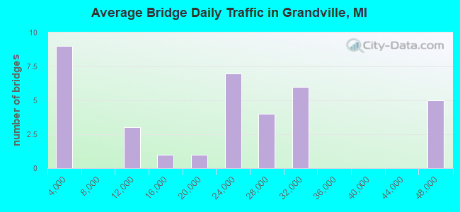
- 749,003Total average daily traffic
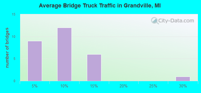
- 51,309Total average daily truck traffic
- National Bridge Inventory (NBI) Registered Bridges for Grandville
- No street view available for this location
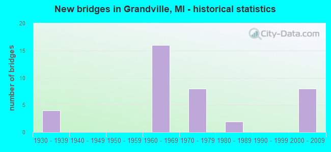
- New bridges - historical statistics
- 41930-1939
- 161960-1969
- 81970-1979
- 21980-1989
- 82000-2009
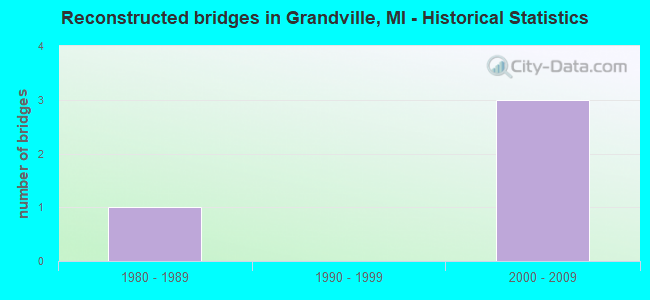
- Reconstructed bridges - Historical Statistics
- 11980-1989
- 01990-1999
- 32000-2009
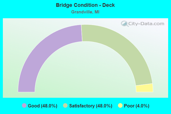
- Bridge Condition - Deck
- 48.0%Good
- 48.0%Satisfactory
- 4.0%Poor
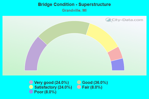
- Bridge Condition - Superstructure
- 24.0%Very good
- 36.0%Good
- 24.0%Satisfactory
- 8.0%Fair
- 8.0%Poor
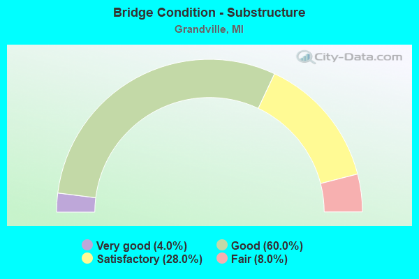
- Bridge Condition - Substructure
- 4.0%Very good
- 60.0%Good
- 28.0%Satisfactory
- 8.0%Fair
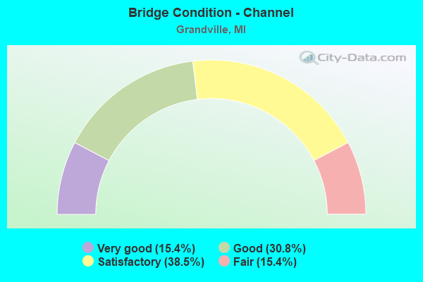
- Bridge Condition - Channel
- 15.4%Very good
- 30.8%Good
- 38.5%Satisfactory
- 15.4%Fair
Find on map >> Show street view
Structure Number: 48, Location: 1.5 MI N OF IRON CO LINE (Lat: 46.440775, Lng: -88.511369), Route carried "on" structure: US 141, Year Built: 1960, Status: Open, Structure Length: 1.06m (3.48ft), Average Daily Traffic: 1,046 (year 2007), Truck Traffic: 27%, Average Future Daily Traffic: 1,088 (year 2018), Design Load: HS 20, Features Intersected: TRACY CREEK
Minimum Vertical Clearance: 30.48m (100.00ft), Kilometerpoint: 2.617, Lanes on structure: 2, Base Highway Network: Yes (Inventory Route: 118, Subroute: 3), Owner: State Highway Agency, Approaching Roadway Width: 12.2m (40.0ft), Material/Design: Steel, Design/Construction: Stringer/Multi-beam, Number Of Spans In Main Unit: 1, Length of Maximum Span: 10.6m (34.8ft), Curb or Sidewalk Widths: Left: 0.4m (1.3ft), Right: 0.4m (1.3ft), Curb-To-Curb Width: 11.6m (38.1ft), Out-to-Out Width: 13.1m (43.0ft)
Condition: Deck: Good, Superstructure: Good, Substructure: Satisfactory, Channel: Good, Operating Rating: 55.1 metric tons, Method Used To Determine Operating Rating: Load Factor (LF) rating reported by rating factor (RF) method using MS18 loading, Inventory Rating: 33.0 metric tons, Method Used To Determine Inventory Rating: Load Factor (LF) rating reported by rating factor (RF) method using MS18 loading, Structural Evaluation: Equal to present minimum criteria, Deck Geometry: Equal to present minimum criteria, Waterway Adequacy: Better than present minimum criteria, Approach Roadway Alignment: Better than present minimum criteria, Designated Inspection Frequency: Every 24 months, Inspection Date: July 2021, Deck Structure Type: Concrete Cast-file-Place, Wearing Surface/Protective System: Wearing Surface: Bituminous
Find on map >> Show street view
Structure Number: 522, Location: IN HERMAN (Lat: 46.667806, Lng: -88.365192), Route carried "on" structure: County highway , Year Built: 1987, Status: Open, Structure Length: 0.67m (2.20ft), Average Daily Traffic: 124 (year 2014), Average Future Daily Traffic: 150 (year 2034), Design Load: HS 20, Features Intersected: DAULTS CREEK, Facility Carried by Structure: KERANEN ROAD
Minimum Vertical Clearance: 30+ m (98+ ft), Kilometerpoint: 0.043, Lanes on structure: 2, Owner: County Highway Agency, Approaching Roadway Width: 7.9m (25.9ft), Material/Design: Steel, Design/Construction: Culvert, Number Of Spans In Main Unit: 3, Length of Maximum Span: 3.6m (11.8ft)
Condition: Channel: Satisfactory, Culverts: Satisfactory, Operating Rating: 33.0 metric tons, Method Used To Determine Operating Rating: Load Factor (LF) rating reported by rating factor (RF) method using MS18 loading, Inventory Rating: 26.2 metric tons, Method Used To Determine Inventory Rating: Load Factor (LF) rating reported by rating factor (RF) method using MS18 loading, Structural Evaluation: Equal to present minimum criteria, Waterway Adequacy: Meets minimum limits, Approach Roadway Alignment: Equal to present minimum criteria, Designated Inspection Frequency: Every 24 months, Inspection Date: September 2021
Find on map >> Show street view
Structure Number: 4799, Location: IN GRANDVILLE (Lat: 42.908625, Lng: -85.776269), Route carried "on" structure: Interstate 196, Year Built: 2007, Status: Open, Structure Length: 3.81m (12.50ft), Average Daily Traffic: 31,705 (year 2007), Truck Traffic: 7%, Average Future Daily Traffic: 48,150 (year 2032), Design Load: HS 25 or greater, Features Intersected: BUCK CR
Minimum Vertical Clearance: 30.48m (100.00ft), Kilometerpoint: 3.782, Lanes on structure: 4, Base Highway Network: Yes (Inventory Route: 40, Subroute: 9), Owner: State Highway Agency, Approaching Roadway Width: 21.3m (69.9ft), Skew: 1 degrees, Material/Design: Prestressed concrete, Design/Construction: Stringer/Multi-beam, Number Of Spans In Main Unit: 1, Length of Maximum Span: 36.9m (121.1ft), Curb-To-Curb Width: 21.5m (70.5ft), Out-to-Out Width: 22.5m (73.8ft)
Condition: Deck: Good, Superstructure: Very good, Substructure: Good, Channel: Good, Operating Rating: 95.9 metric tons, Method Used To Determine Operating Rating: Load Factor (LF) rating reported by rating factor (RF) method using MS18 loading, Inventory Rating: 47.6 metric tons, Method Used To Determine Inventory Rating: Load Factor (LF) rating reported by rating factor (RF) method using MS18 loading, Structural Evaluation: Better than present minimum criteria, Deck Geometry: Better than present minimum criteria, Waterway Adequacy: Equal to present minimum criteria, Approach Roadway Alignment: Equal to present desirable criteria, Designated Inspection Frequency: Every 24 months, Inspection Date: August 2020, Deck Structure Type: Concrete Cast-file-Place, Wearing Surface/Protective System: Wearing Surface: Monolithic Concrete, Deck Protection: Epoxy Coated Reinforcing
Find on map >> Show street view
Structure Number: 48, Location: IN GRANDVILLE (Lat: 42.907967, Lng: -85.775642), Route carried "on" structure: Interstate 196, Year Built: 2007, Status: Open, Structure Length: 3.66m (12.01ft), Average Daily Traffic: 31,705 (year 2007), Truck Traffic: 7%, Average Future Daily Traffic: 48,150 (year 2032), Design Load: HS 25 or greater, Features Intersected: BUCK CREEK
Minimum Vertical Clearance: 30.48m (100.00ft), Kilometerpoint: 3.752, Lanes on structure: 3, Base Highway Network: Yes (Inventory Route: 40, Subroute: 5), Owner: State Highway Agency, Approaching Roadway Width: 17.7m (58.1ft), Material/Design: Prestressed concrete, Design/Construction: Stringer/Multi-beam, Number Of Spans In Main Unit: 1, Length of Maximum Span: 34.7m (113.8ft), Curb-To-Curb Width: 17.7m (58.1ft), Out-to-Out Width: 18.7m (61.4ft)
Condition: Deck: Good, Superstructure: Very good, Substructure: Very good, Channel: Very good, Operating Rating: 84.6 metric tons, Method Used To Determine Operating Rating: Load Factor (LF) rating reported by rating factor (RF) method using MS18 loading, Inventory Rating: 38.9 metric tons, Method Used To Determine Inventory Rating: Load Factor (LF) rating reported by rating factor (RF) method using MS18 loading, Structural Evaluation: Equal to present desirable criteria, Deck Geometry: Better than present minimum criteria, Waterway Adequacy: Somewhat better than minimum adequacy, Approach Roadway Alignment: Equal to present desirable criteria, Designated Inspection Frequency: Every 24 months, Inspection Date: August 2020, Deck Structure Type: Concrete Cast-file-Place, Wearing Surface/Protective System: Wearing Surface: Monolithic Concrete, Deck Protection: Epoxy Coated Reinforcing
Find on map >> Show street view
Structure Number: 4803, Location: IN GRANDVILLE (Lat: 42.906650, Lng: -85.777817), Route carried "on" structure: Interstate 196, Year Built: 2007, Status: Open, Structure Length: 18.02m (59.12ft), Average Daily Traffic: 31,705 (year 2007), Truck Traffic: 10%, Average Future Daily Traffic: 48,150 (year 2032), Design Load: HS 25 or greater, Features Intersected: CSX RR & I-196 RMP
Minimum Vertical Clearance: 30.48m (100.00ft), Kilometerpoint: 3.483, Lanes on structure: 2, Lanes under structure: 1, Base Highway Network: Yes (Inventory Route: 40, Subroute: 5), Owner: State Highway Agency, Approaching Roadway Width: 17.7m (58.1ft), Material/Design: Steel continuous, Design/Construction: Stringer/Multi-beam, Number Of Spans In Main Unit: 4, Length of Maximum Span: 52.6m (172.6ft), Curb-To-Curb Width: 17.7m (58.1ft), Out-to-Out Width: 18.7m (61.4ft)
Condition: Deck: Satisfactory, Superstructure: Good, Substructure: Good, Operating Rating: 95.7 metric tons, Method Used To Determine Operating Rating: Load Factor (LF), Inventory Rating: 57.3 metric tons, Method Used To Determine Inventory Rating: Load Factor (LF), Structural Evaluation: Better than present minimum criteria, Deck Geometry: Superior to present desirable criteria, Underclear: Superior to present desirable criteria, Approach Roadway Alignment: Better than present minimum criteria, Designated Inspection Frequency: Every 24 months, Inspection Date: October 2021, Deck Structure Type: Concrete Cast-file-Place, Wearing Surface/Protective System: Wearing Surface: Monolithic Concrete, Deck Protection: Epoxy Coated Reinforcing
Find on map >> Show street view
Structure Number: 4804, Location: IN GRANDVILLE (Lat: 42.906597, Lng: -85.779797), Route carried "on" structure: Interstate 196, Year Built: 2007, Status: Open, Structure Length: 6.71m (22.01ft), Average Daily Traffic: 31,705 (year 2007), Truck Traffic: 7%, Average Future Daily Traffic: 58,527 (year 2032), Design Load: HS 25 or greater, Features Intersected: CSX RR
Minimum Vertical Clearance: 30.48m (100.00ft), Kilometerpoint: 3.446, Lanes on structure: 3, Base Highway Network: Yes (Inventory Route: 40, Subroute: 9), Owner: State Highway Agency, Approaching Roadway Width: 17.0m (55.8ft), Skew: 3 degrees, Material/Design: Steel continuous, Design/Construction: Stringer/Multi-beam, Number Of Spans In Main Unit: 2, Length of Maximum Span: 32.6m (107.0ft), Curb-To-Curb Width: 19.5m (64.0ft), Out-to-Out Width: 20.5m (67.3ft)
Condition: Deck: Satisfactory, Superstructure: Very good, Substructure: Good, Operating Rating: 84.9 metric tons, Method Used To Determine Operating Rating: Load Factor (LF), Inventory Rating: 50.9 metric tons, Method Used To Determine Inventory Rating: Load Factor (LF), Structural Evaluation: Better than present minimum criteria, Deck Geometry: Superior to present desirable criteria, Underclear: Better than present minimum criteria, Approach Roadway Alignment: Equal to present desirable criteria, Designated Inspection Frequency: Every 24 months, Inspection Date: August 2020, Deck Structure Type: Concrete Cast-file-Place, Wearing Surface/Protective System: Wearing Surface: Monolithic Concrete, Deck Protection: Epoxy Coated Reinforcing
Find on map >> Show street view
Structure Number: 4812, Location: IN GRANDVILLE (Lat: 42.904908, Lng: -85.779839), Route carried "on" structure: Interstate 196, Year Built: 1965, Status: Open, Structure Length: 6.86m (22.51ft), Average Daily Traffic: 31,705 (year 2007), Truck Traffic: 10%, Average Future Daily Traffic: 33,727 (year 2018), Design Load: HS 20+Mod, Features Intersected: CHICAGO DRIVE
Minimum Vertical Clearance: 30.48m (100.00ft), Kilometerpoint: 3.264, Lanes on structure: 3, Lanes under structure: 5, Base Highway Network: Yes (Inventory Route: 40, Subroute: 5), Owner: State Highway Agency, Approaching Roadway Width: 13.7m (44.9ft), Skew: 4 degrees, Material/Design: Steel, Design/Construction: Stringer/Multi-beam, Number Of Spans In Main Unit: 3, Length of Maximum Span: 37.2m (122.0ft), Curb or Sidewalk Widths: Left: 0.1m (0.3ft), Right: 0.1m (0.3ft), Curb-To-Curb Width: 13.8m (45.3ft), Out-to-Out Width: 14.6m (47.9ft)
Condition: Deck: Satisfactory, Superstructure: Satisfactory, Substructure: Satisfactory, Operating Rating: 71.3 metric tons, Method Used To Determine Operating Rating: Load Factor (LF) rating reported by rating factor (RF) method using MS18 loading, Inventory Rating: 42.8 metric tons, Method Used To Determine Inventory Rating: Load Factor (LF) rating reported by rating factor (RF) method using MS18 loading, Structural Evaluation: Equal to present minimum criteria, Deck Geometry: Meets minimum limits, Underclear: Better than present minimum criteria, Approach Roadway Alignment: Equal to present desirable criteria, Designated Inspection Frequency: Every 24 months, Inspection Date: July 2020, Deck Structure Type: Concrete Cast-file-Place, Wearing Surface/Protective System: Wearing Surface: Latex Concrete
Find on map >> Show street view
Structure Number: 4813, Location: IN GRANDVILLE (Lat: 42.904714, Lng: -85.780908), Route carried "on" structure: Interstate 196, Year Built: 1972, Status: Open, Structure Length: 6.15m (20.18ft), Average Daily Traffic: 31,705 (year 2007), Truck Traffic: 10%, Average Future Daily Traffic: 33,727 (year 2018), Design Load: HS 20+Mod, Features Intersected: CHICAGO DRIVE
Minimum Vertical Clearance: 30.48m (100.00ft), Kilometerpoint: 3.182, Lanes on structure: 3, Lanes under structure: 5, Base Highway Network: Yes (Inventory Route: 40, Subroute: 9), Owner: State Highway Agency, Approaching Roadway Width: 14.0m (45.9ft), Skew: 2 degrees, Material/Design: Steel, Design/Construction: Stringer/Multi-beam, Number Of Spans In Main Unit: 3, Length of Maximum Span: 34.4m (112.9ft), Curb-To-Curb Width: 17.9m (58.7ft), Out-to-Out Width: 18.4m (60.4ft)
Condition: Deck: Poor, Superstructure: Poor, Substructure: Good, Operating Rating: 65.4 metric tons, Method Used To Determine Operating Rating: Load Factor (LF) rating reported by rating factor (RF) method using MS18 loading, Inventory Rating: 39.2 metric tons, Method Used To Determine Inventory Rating: Load Factor (LF) rating reported by rating factor (RF) method using MS18 loading, Structural Evaluation: Meets minimum limits, Deck Geometry: Better than present minimum criteria, Underclear: Superior to present desirable criteria, Approach Roadway Alignment: Equal to present desirable criteria, Designated Inspection Frequency: Every 10 months, Other Special Inspection Frequency: Every 24 months, Inspection Date: September 2021, Other Special Inspection Date: July 2021, Bridge Improvement Cost: $201,000, Deck Structure Type: Concrete Cast-file-Place, Wearing Surface/Protective System: Wearing Surface: Latex Concrete
Find on map >> Show street view
Structure Number: 4814, Location: IN GRANDVILLE (Lat: 42.914442, Lng: -85.765356), Route carried "on" structure: Interstate 196, Year Built: 1965, Status: Open, Structure Length: 4.77m (15.65ft), Average Daily Traffic: 47,200 (year 2015), Truck Traffic: 8%, Average Future Daily Traffic: 52,150 (year 2035), Design Load: HS 20+Mod, Features Intersected: M-11
Minimum Vertical Clearance: 30.48m (100.00ft), Kilometerpoint: 4.893, Lanes on structure: 2, Lanes under structure: 4, Base Highway Network: Yes (Inventory Route: 40, Subroute: 9), Owner: State Highway Agency, Approaching Roadway Width: 12.2m (40.0ft), Material/Design: Steel, Design/Construction: Stringer/Multi-beam, Number Of Spans In Main Unit: 3, Length of Maximum Span: 27.8m (91.2ft), Curb-To-Curb Width: 12.0m (39.4ft), Out-to-Out Width: 13.0m (42.7ft)
Condition: Deck: Satisfactory, Superstructure: Good, Substructure: Good, Operating Rating: 71.9 metric tons, Method Used To Determine Operating Rating: Load Factor (LF) rating reported by rating factor (RF) method using MS18 loading, Inventory Rating: 43.1 metric tons, Method Used To Determine Inventory Rating: Load Factor (LF) rating reported by rating factor (RF) method using MS18 loading, Structural Evaluation: Better than present minimum criteria, Deck Geometry: Equal to present minimum criteria, Underclear: Meets minimum limits, Approach Roadway Alignment: Equal to present desirable criteria, Designated Inspection Frequency: Every 24 months, Inspection Date: June 2020, Deck Structure Type: Concrete Cast-file-Place, Wearing Surface/Protective System: Wearing Surface: Latex Concrete
Find on map >> Show street view
Structure Number: 4815, Location: IN GRANDVILLE (M-11 28TH (Lat: 42.914292, Lng: -85.765044), Route carried "on" structure: Interstate 196, Year Built: 1965, Status: Open, Structure Length: 4.77m (15.65ft), Average Daily Traffic: 47,200 (year 2015), Truck Traffic: 8%, Average Future Daily Traffic: 52,150 (year 2035), Design Load: HS 20+Mod, Features Intersected: M-11
Minimum Vertical Clearance: 30.48m (100.00ft), Kilometerpoint: 4.872, Lanes on structure: 3, Lanes under structure: 4, Base Highway Network: Yes (Inventory Route: 40, Subroute: 5), Owner: State Highway Agency, Approaching Roadway Width: 13.7m (44.9ft), Material/Design: Steel, Design/Construction: Stringer/Multi-beam, Number Of Spans In Main Unit: 3, Length of Maximum Span: 27.8m (91.2ft), Curb-To-Curb Width: 13.6m (44.6ft), Out-to-Out Width: 14.5m (47.6ft)
Condition: Deck: Satisfactory, Superstructure: Good, Substructure: Good, Operating Rating: 66.7 metric tons, Method Used To Determine Operating Rating: Load Factor (LF) rating reported by rating factor (RF) method using MS18 loading, Inventory Rating: 39.9 metric tons, Method Used To Determine Inventory Rating: Load Factor (LF) rating reported by rating factor (RF) method using MS18 loading, Structural Evaluation: Better than present minimum criteria, Deck Geometry: High priority of corrective action, Underclear: Meets minimum limits, Approach Roadway Alignment: Better than present minimum criteria, Designated Inspection Frequency: Every 24 months, Inspection Date: June 2020, Deck Structure Type: Concrete Cast-file-Place, Wearing Surface/Protective System: Wearing Surface: Latex Concrete
Find on map >> Show street view
Structure Number: 4816, Location: IN GRANDVILLE (I-196 EB) (Lat: 42.917175, Lng: -85.762547), Route carried "on" structure: Ramp Interstate 196, Year Built: 1965, Status: Open, Structure Length: 8.88m (29.13ft), Average Daily Traffic: 1,400 (year 2012), Truck Traffic: 5%, Average Future Daily Traffic: 1,610 (year 2032), Design Load: HS 20+Mod, Features Intersected: I-196 EB
Minimum Vertical Clearance: 30.48m (100.00ft), Kilometerpoint: 0.359, Lanes on structure: 1, Lanes under structure: 2, Owner: State Highway Agency, Approaching Roadway Width: 12.8m (42.0ft), Skew: 6 degrees, Material/Design: Steel, Design/Construction: Stringer/Multi-beam, Number Of Spans In Main Unit: 3, Length of Maximum Span: 41.3m (135.5ft), Curb-To-Curb Width: 6.4m (21.0ft), Out-to-Out Width: 7.4m (24.3ft)
Condition: Deck: Good, Superstructure: Good, Substructure: Good, Operating Rating: 65.8 metric tons, Method Used To Determine Operating Rating: Load Factor (LF) rating reported by rating factor (RF) method using MS18 loading, Inventory Rating: 39.5 metric tons, Method Used To Determine Inventory Rating: Load Factor (LF) rating reported by rating factor (RF) method using MS18 loading, Structural Evaluation: Better than present minimum criteria, Deck Geometry: Somewhat better than minimum adequacy, Underclear: Meets minimum limits, Approach Roadway Alignment: Equal to present desirable criteria, Length Of Structure Improvement: 8.87m (29.10ft), Designated Inspection Frequency: Every 24 months, Inspection Date: June 2020, Bridge Improvement Cost: $152,000, Roadway Improvement Cost: $8,000, Total Project Cost: $93,000, Deck Structure Type: Concrete Cast-file-Place, Wearing Surface/Protective System: Wearing Surface: Latex Concrete
Find on map >> Show street view
Structure Number: 4833, Location: NE LIMITS OF GRANDVILLE (Lat: 42.927342, Lng: -85.744236), Route carried "on" structure: Interstate 196, Year Built: 1965, Status: Open, Structure Length: 0.98m (3.22ft), Average Daily Traffic: 47,200 (year 2015), Truck Traffic: 8%, Average Future Daily Traffic: 52,150 (year 2035), Design Load: HS 20+Mod, Features Intersected: SERVICE RD
Minimum Vertical Clearance: 30.48m (100.00ft), Kilometerpoint: 7.136, Lanes on structure: 2, Lanes under structure: 1, Base Highway Network: Yes (Inventory Route: 40, Subroute: 5), Owner: State Highway Agency, Approaching Roadway Width: 12.8m (42.0ft), Skew: 2 degrees, Material/Design: Concrete, Design/Construction: Slab, Number Of Spans In Main Unit: 1, Length of Maximum Span: 9.7m (31.8ft), Curb-To-Curb Width: 12.0m (39.4ft), Out-to-Out Width: 13.1m (43.0ft)
Condition: Deck: Good, Superstructure: Good, Substructure: Good, Operating Rating: 72.9 metric tons, Method Used To Determine Operating Rating: Load Factor (LF) rating reported by rating factor (RF) method using MS18 loading, Inventory Rating: 43.7 metric tons, Method Used To Determine Inventory Rating: Load Factor (LF) rating reported by rating factor (RF) method using MS18 loading, Structural Evaluation: Better than present minimum criteria, Deck Geometry: Equal to present minimum criteria, Underclear: High priority of corrective action, Approach Roadway Alignment: Equal to present desirable criteria, Designated Inspection Frequency: Every 24 months, Inspection Date: June 2020, Deck Structure Type: Concrete Cast-file-Place, Wearing Surface/Protective System: Wearing Surface: Monolithic Concrete
Find on map >> Show street view
Structure Number: 4834, Location: NE LIMITS OF GRANDVILLE (Lat: 42.927703, Lng: -85.744253), Route carried "on" structure: Interstate 196, Year Built: 1965, Status: Open, Structure Length: 1.01m (3.31ft), Average Daily Traffic: 47,200 (year 2015), Truck Traffic: 8%, Average Future Daily Traffic: 52,150 (year 2035), Design Load: HS 20+Mod, Features Intersected: SERVICE RD
Minimum Vertical Clearance: 30.48m (100.00ft), Kilometerpoint: 7.209, Lanes on structure: 2, Lanes under structure: 1, Base Highway Network: Yes (Inventory Route: 40, Subroute: 9), Owner: State Highway Agency, Approaching Roadway Width: 12.8m (42.0ft), Skew: 3 degrees, Material/Design: Concrete, Design/Construction: Slab, Number Of Spans In Main Unit: 1, Length of Maximum Span: 10.0m (32.8ft), Curb-To-Curb Width: 12.0m (39.4ft), Out-to-Out Width: 13.1m (43.0ft)
Condition: Deck: Satisfactory, Superstructure: Satisfactory, Substructure: Satisfactory, Operating Rating: 68.4 metric tons, Method Used To Determine Operating Rating: Load Factor (LF) rating reported by rating factor (RF) method using MS18 loading, Inventory Rating: 40.8 metric tons, Method Used To Determine Inventory Rating: Load Factor (LF) rating reported by rating factor (RF) method using MS18 loading, Structural Evaluation: Equal to present minimum criteria, Deck Geometry: Equal to present minimum criteria, Underclear: High priority of corrective action, Approach Roadway Alignment: Equal to present desirable criteria, Designated Inspection Frequency: Every 24 months, Inspection Date: June 2020, Deck Structure Type: Concrete Cast-file-Place, Wearing Surface/Protective System: Wearing Surface: Monolithic Concrete
Find on map >> Show street view
Structure Number: 4836, Location: IN GRANDVILLE (Lat: 42.885008, Lng: -85.777000), Route carried "on" structure: County highway 2001, Year Built: 1972, Status: Open, Structure Length: 7.31m (23.98ft), Average Daily Traffic: 24,200 (year 1988), Average Future Daily Traffic: 22,000 (year 2010), Design Load: H 20, Features Intersected: I-196, Facility Carried by Structure: 44TH ST
Minimum Vertical Clearance: 30.48m (100.00ft), Kilometerpoint: 0.422, Lanes on structure: 6, Lanes under structure: 5, Owner: State Highway Agency, Approaching Roadway Width: 28.0m (91.9ft), Material/Design: Steel, Design/Construction: Stringer/Multi-beam, Number Of Spans In Main Unit: 2, Length of Maximum Span: 36.5m (119.8ft), Curb or Sidewalk Widths: Left: 0.2m (0.7ft), Right: 0.2m (0.7ft), Curb-To-Curb Width: 27.0m (88.6ft), Out-to-Out Width: 28.2m (92.5ft)
Condition: Deck: Satisfactory, Superstructure: Good, Substructure: Satisfactory, Operating Rating: 84.1 metric tons, Method Used To Determine Operating Rating: Load Factor (LF), Inventory Rating: 50.4 metric tons, Method Used To Determine Inventory Rating: Load Factor (LF), Structural Evaluation: Equal to present minimum criteria, Deck Geometry: Better than present minimum criteria, Underclear: Somewhat better than minimum adequacy, Approach Roadway Alignment: Equal to present desirable criteria, Designated Inspection Frequency: Every 24 months, Inspection Date: August 2020, Deck Structure Type: Concrete Cast-file-Place, Wearing Surface/Protective System: Wearing Surface: Monolithic Concrete
Find on map >> Show street view
Structure Number: 4837, Location: IN GRANDVILLE (Lat: 42.899756, Lng: -85.781133), Route carried "on" structure: Interstate 196, Year Built: 1972, Year Reconstructed: 2007, Status: Open, Structure Length: 3.56m (11.68ft), Average Daily Traffic: 22,832 (year 2007), Truck Traffic: 10%, Average Future Daily Traffic: 57,000 (year 2025), Design Load: HS 20, Features Intersected: 36TH ST
Minimum Vertical Clearance: 30.48m (100.00ft), Kilometerpoint: 2.630, Lanes on structure: 2, Lanes under structure: 2, Base Highway Network: Yes (Inventory Route: 40, Subroute: 9), Owner: State Highway Agency, Approaching Roadway Width: 12.2m (40.0ft), Material/Design: Prestressed concrete, Design/Construction: Stringer/Multi-beam, Number Of Spans In Main Unit: 3, Length of Maximum Span: 17.9m (58.7ft), Curb-To-Curb Width: 14.7m (48.2ft), Out-to-Out Width: 15.2m (49.9ft)
Condition: Deck: Good, Superstructure: Satisfactory, Substructure: Good, Operating Rating: 50.9 metric tons, Method Used To Determine Operating Rating: Load Factor (LF), Inventory Rating: 30.5 metric tons, Method Used To Determine Inventory Rating: Load Factor (LF), Structural Evaluation: Equal to present minimum criteria, Deck Geometry: Superior to present desirable criteria, Underclear: Equal to present minimum criteria, Approach Roadway Alignment: Equal to present desirable criteria, Designated Inspection Frequency: Every 24 months, Inspection Date: August 2020, Deck Structure Type: Concrete Cast-file-Place, Wearing Surface/Protective System: Wearing Surface: Latex Concrete
Find on map >> Show street view
Structure Number: 4838, Location: IN GRANDVILLE (Lat: 42.899739, Lng: -85.780700), Route carried "on" structure: Interstate 196, Year Built: 1972, Year Reconstructed: 2007, Status: Open, Structure Length: 3.55m (11.65ft), Average Daily Traffic: 22,832 (year 2007), Truck Traffic: 10%, Average Future Daily Traffic: 57,000 (year 2025), Design Load: HS 20, Features Intersected: 36TH ST
Minimum Vertical Clearance: 30.48m (100.00ft), Kilometerpoint: 2.678, Lanes on structure: 3, Lanes under structure: 2, Base Highway Network: Yes (Inventory Route: 40, Subroute: 5), Owner: State Highway Agency, Approaching Roadway Width: 12.2m (40.0ft), Material/Design: Prestressed concrete, Design/Construction: Stringer/Multi-beam, Number Of Spans In Main Unit: 3, Length of Maximum Span: 17.9m (58.7ft), Curb-To-Curb Width: 17.0m (55.8ft), Out-to-Out Width: 18.0m (59.1ft)
Condition: Deck: Good, Superstructure: Good, Substructure: Good, Operating Rating: 65.6 metric tons, Method Used To Determine Operating Rating: Load Factor (LF), Inventory Rating: 39.3 metric tons, Method Used To Determine Inventory Rating: Load Factor (LF), Structural Evaluation: Better than present minimum criteria, Deck Geometry: Equal to present minimum criteria, Underclear: Equal to present minimum criteria, Approach Roadway Alignment: Equal to present desirable criteria, Designated Inspection Frequency: Every 24 months, Inspection Date: August 2020, Deck Structure Type: Concrete Cast-file-Place, Wearing Surface/Protective System: Wearing Surface: Latex Concrete
Find on map >> Show street view
Structure Number: 4862, Location: IN GRANDVILLE (Lat: 42.914900, Lng: -85.766492), Route carried "on" structure: State highway 11, Year Built: 1930, Year Reconstructed: 1985, Status: Open, Structure Length: 16.76m (54.99ft), Average Daily Traffic: 21,410 (year 2007), Truck Traffic: 8%, Average Future Daily Traffic: 30,419 (year 2018), Design Load: H 15, Features Intersected: GRAND RIVER
Minimum Vertical Clearance: 30.48m (100.00ft), Kilometerpoint: 10.585, Lanes on structure: 4, Base Highway Network: Yes (Inventory Route: 40, Subroute: 8), Owner: State Highway Agency, Approaching Roadway Width: 16.5m (54.1ft), Navigation Control: Yes ( Vertical Clearance: 0.3m (1.0ft), Horizontal Clearance: 20.0m (65.6ft)), Material/Design: Steel, Design/Construction: Stringer/Multi-beam, Number Of Spans In Main Unit: 8, Length of Maximum Span: 22.9m (75.1ft), Curb or Sidewalk Widths: Left: 0.0m, Right: 1.5m (4.9ft), Curb-To-Curb Width: 18.3m (60.0ft), Out-to-Out Width: 20.8m (68.2ft)
Condition: Deck: Good, Superstructure: Fair, Substructure: Satisfactory, Channel: Satisfactory, Operating Rating: 75.2 metric tons, Method Used To Determine Operating Rating: Load Factor (LF), Inventory Rating: 45.0 metric tons, Method Used To Determine Inventory Rating: Load Factor (LF), Structural Evaluation: Somewhat better than minimum adequacy, Deck Geometry: Somewhat better than minimum adequacy, Waterway Adequacy: Equal to present desirable criteria, Approach Roadway Alignment: Better than present minimum criteria, Designated Inspection Frequency: Every 24 months, Underwater Inspection Frequency: Every 60 months, Inspection Date: October 2021, Underwater Inspection Date: June 2020, Deck Structure Type: Concrete Cast-file-Place, Wearing Surface/Protective System: Wearing Surface: Latex Concrete
Find on map >> Show street view
Structure Number: 4863, Location: IN GRANDVILLE (Lat: 42.913578, Lng: -85.750619), Route carried "on" structure: State highway 11, Year Built: 1936, Status: Open, Structure Length: 8.46m (27.76ft), Average Daily Traffic: 22,500 (year 2013), Truck Traffic: 4%, Average Future Daily Traffic: 25,875 (year 2033), Design Load: H 15, Features Intersected: CSX RR & CHICAGO DR
Minimum Vertical Clearance: 30.48m (100.00ft), Kilometerpoint: 12.008, Lanes on structure: 4, Lanes under structure: 4, Base Highway Network: Yes (Inventory Route: 40, Subroute: 8), Owner: State Highway Agency, Approaching Roadway Width: 15.0m (49.2ft), Skew: 4 degrees, Material/Design: Steel, Design/Construction: Stringer/Multi-beam, Number Of Spans In Main Unit: 4, Length of Maximum Span: 26.6m (87.3ft), Curb-To-Curb Width: 15.8m (51.8ft), Out-to-Out Width: 16.9m (55.4ft)
Condition: Deck: Satisfactory, Superstructure: Fair, Substructure: Good, Operating Rating: 66.4 metric tons, Method Used To Determine Operating Rating: Load Factor (LF) rating reported by rating factor (RF) method using MS18 loading, Inventory Rating: 39.9 metric tons, Method Used To Determine Inventory Rating: Load Factor (LF) rating reported by rating factor (RF) method using MS18 loading, Structural Evaluation: Somewhat better than minimum adequacy, Deck Geometry: Meets minimum limits, Underclear: High priority of corrective action, Approach Roadway Alignment: Equal to present desirable criteria, Designated Inspection Frequency: Every 24 months, Inspection Date: March 2021, Deck Structure Type: Concrete Cast-file-Place, Wearing Surface/Protective System: Wearing Surface: Monolithic Concrete
Find on map >> Show street view
Structure Number: 5099, Location: 0.98 MI S OF CHICAGO DR (Lat: 42.902483, Lng: -85.762692), Route carried "on" structure: County highway 2001, Year Built: 1966, Year Reconstructed: 2006, Status: Open, Structure Length: 1.65m (5.41ft), Average Daily Traffic: 10,800 (year 2006), Truck Traffic: 4%, Average Future Daily Traffic: 15,000 (year 2026), Design Load: HS 20+Mod, Features Intersected: BUCK CREEK, Facility Carried by Structure: WILSON AVE
Minimum Vertical Clearance: 30+ m (98+ ft), Kilometerpoint: 14.909, Lanes on structure: 4, Owner: City or Municipal Highway Agency, Approaching Roadway Width: 12.2m (40.0ft), Material/Design: Steel, Design/Construction: Stringer/Multi-beam, Number Of Spans In Main Unit: 2, Length of Maximum Span: 7.9m (25.9ft), Curb or Sidewalk Widths: Left: 3.0m (9.8ft), Right: 3.0m (9.8ft), Curb-To-Curb Width: 15.5m (50.9ft), Out-to-Out Width: 22.6m (74.1ft)
Condition: Deck: Satisfactory, Superstructure: Satisfactory, Substructure: Fair, Channel: Fair, Operating Rating: 58.0 metric tons, Method Used To Determine Operating Rating: Load Factor (LF) rating reported by rating factor (RF) method using MS18 loading, Inventory Rating: 34.7 metric tons, Method Used To Determine Inventory Rating: Load Factor (LF) rating reported by rating factor (RF) method using MS18 loading, Structural Evaluation: Somewhat better than minimum adequacy, Deck Geometry: Meets minimum limits, Waterway Adequacy: Equal to present minimum criteria, Approach Roadway Alignment: Equal to present desirable criteria, Designated Inspection Frequency: Every 24 months, Inspection Date: March 2021, Deck Structure Type: Concrete Cast-file-Place, Wearing Surface/Protective System: Wearing Surface: Bituminous
Find on map >> Show street view
Structure Number: 5218, Location: 0.37 MI S OF CHICAGO DRV (Lat: 42.903758, Lng: -85.772211), Route carried "on" structure: City street , Year Built: 1965, Status: Open, Structure Length: 1.65m (5.41ft), Average Daily Traffic: 12,000 (year 2001), Truck Traffic: 3%, Average Future Daily Traffic: 15,000 (year 2026), Design Load: HS 20+Mod, Features Intersected: BUCK CREEK, Facility Carried by Structure: CANAL AVE
Minimum Vertical Clearance: 30.48m (100.00ft), Kilometerpoint: 5.472, Lanes on structure: 4, Owner: City or Municipal Highway Agency, Approaching Roadway Width: 12.2m (40.0ft), Material/Design: Prestressed concrete, Design/Construction: Box Beam or Girders - Multiple, Number Of Spans In Main Unit: 1, Length of Maximum Span: 15.8m (51.8ft), Curb or Sidewalk Widths: Left: 1.1m (3.6ft), Right: 1.1m (3.6ft), Curb-To-Curb Width: 12.2m (40.0ft), Out-to-Out Width: 15.2m (49.9ft)
Condition: Deck: Satisfactory, Superstructure: Poor, Substructure: Fair, Channel: Satisfactory, Operating Rating: 54.6 metric tons, Method Used To Determine Operating Rating: Field evaluation and documented engineering judgment, Inventory Rating: 32.7 metric tons, Method Used To Determine Inventory Rating: Field evaluation and documented engineering judgment, Structural Evaluation: Meets minimum limits, Deck Geometry: High priority of replacement, Waterway Adequacy: Equal to present desirable criteria, Approach Roadway Alignment: Equal to present desirable criteria, Designated Inspection Frequency: Every 24 months, Inspection Date: March 2021, Deck Structure Type: Concrete Precast Panels, Wearing Surface/Protective System: Wearing Surface: Bituminous
Find on map >> Show street view
Structure Number: 5219, Location: 0.12 MI S OF 34TH ST (Lat: 42.902108, Lng: -85.743853), Route carried "on" structure: City street , Year Built: 1965, Status: Open, Structure Length: 1.92m (6.30ft), Average Daily Traffic: 10,300 (year 2003), Truck Traffic: 3%, Average Future Daily Traffic: 13,400 (year 2023), Design Load: HS 20+Mod, Features Intersected: BUCK CREEK, Facility Carried by Structure: IVANREST AVE
Minimum Vertical Clearance: 30.48m (100.00ft), Kilometerpoint: 8.370, Lanes on structure: 4, Owner: City or Municipal Highway Agency, Approaching Roadway Width: 13.4m (44.0ft), Skew: 2 degrees, Material/Design: Prestressed concrete, Design/Construction: Box Beam or Girders - Multiple, Number Of Spans In Main Unit: 1, Length of Maximum Span: 16.4m (53.8ft), Curb or Sidewalk Widths: Left: 1.9m (6.2ft), Right: 1.2m (3.9ft), Curb-To-Curb Width: 14.3m (46.9ft), Out-to-Out Width: 18.2m (59.7ft)
Condition: Deck: Good, Superstructure: Satisfactory, Substructure: Satisfactory, Channel: Satisfactory, Operating Rating: 56.8 metric tons, Method Used To Determine Operating Rating: Field evaluation and documented engineering judgment, Inventory Rating: 37.5 metric tons, Method Used To Determine Inventory Rating: Field evaluation and documented engineering judgment, Structural Evaluation: Equal to present minimum criteria, Deck Geometry: High priority of replacement, Waterway Adequacy: Equal to present desirable criteria, Approach Roadway Alignment: Equal to present desirable criteria, Designated Inspection Frequency: Every 24 months, Inspection Date: March 2021, Deck Structure Type: Concrete Precast Panels, Wearing Surface/Protective System: Wearing Surface: Bituminous, Membrane: Preformed Fabric
Find on map >> Show street view
Structure Number: 522, Location: IN GRANDVILLE (Lat: 42.905822, Lng: -85.774922), Route carried "on" structure: City street , Year Built: 1933, Status: Open, Structure Length: 1.37m (4.49ft), Average Daily Traffic: 24,000 (year 2004), Truck Traffic: 8%, Average Future Daily Traffic: 31,200 (year 2024), Design Load: HS 20+Mod, Features Intersected: BUCK CR, Facility Carried by Structure: CHICAGO DRIVE
Minimum Vertical Clearance: 30.48m (100.00ft), Kilometerpoint: 0.570, Lanes on structure: 5, Owner: City or Municipal Highway Agency, Approaching Roadway Width: 12.2m (40.0ft), Material/Design: Steel, Design/Construction: Stringer/Multi-beam, Number Of Spans In Main Unit: 1, Length of Maximum Span: 13.2m (43.3ft), Curb or Sidewalk Widths: Left: 0.2m (0.7ft), Right: 1.5m (4.9ft), Curb-To-Curb Width: 20.4m (66.9ft), Out-to-Out Width: 22.5m (73.8ft)
Condition: Deck: Satisfactory, Superstructure: Satisfactory, Substructure: Satisfactory, Channel: Fair, Operating Rating: 50.5 metric tons, Method Used To Determine Operating Rating: Load Factor (LF) rating reported by rating factor (RF) method using MS18 loading, Inventory Rating: 30.1 metric tons, Method Used To Determine Inventory Rating: Load Factor (LF) rating reported by rating factor (RF) method using MS18 loading, Structural Evaluation: Equal to present minimum criteria, Deck Geometry: Somewhat better than minimum adequacy, Waterway Adequacy: Equal to present minimum criteria, Approach Roadway Alignment: Equal to present desirable criteria, Designated Inspection Frequency: Every 24 months, Inspection Date: March 2021, Deck Structure Type: Concrete Cast-file-Place, Wearing Surface/Protective System: Wearing Surface: Bituminous
Find on map >> Show street view
Structure Number: 8847, Location: SECTION 25 GEORGETOWN TWP (Lat: 42.883347, Lng: -85.786856), Route carried "on" structure: County highway 2001, Year Built: 1986, Status: Open, Structure Length: 2.31m (7.58ft), Average Daily Traffic: 24,050 (year 2020), Truck Traffic: 3%, Average Future Daily Traffic: 43,450 (year 2040), Design Load: HS 20, Features Intersected: E BRANCH - RUSH CREEK, Facility Carried by Structure: 44TH STREET
Minimum Vertical Clearance: 30.48m (100.00ft), Kilometerpoint: 3.158, Lanes on structure: 2, Base Highway Network: Yes (Inventory Route: 75, Subroute: 4), Owner: County Highway Agency, Approaching Roadway Width: 19.2m (63.0ft), Material/Design: Prestressed concrete, Design/Construction: Box Beam or Girders - Multiple, Number Of Spans In Main Unit: 2, Length of Maximum Span: 11.5m (37.7ft), Curb or Sidewalk Widths: Left: 0.0m, Right: 2.4m (7.9ft), Curb-To-Curb Width: 20.4m (66.9ft), Out-to-Out Width: 23.8m (78.1ft)
Condition: Deck: Good, Superstructure: Good, Substructure: Good, Channel: Good, Operating Rating: 77.8 metric tons, Method Used To Determine Operating Rating: Load Factor (LF) rating reported by rating factor (RF) method using MS18 loading, Inventory Rating: 46.7 metric tons, Method Used To Determine Inventory Rating: Load Factor (LF) rating reported by rating factor (RF) method using MS18 loading, Structural Evaluation: Better than present minimum criteria, Deck Geometry: Superior to present desirable criteria, Waterway Adequacy: Equal to present desirable criteria, Approach Roadway Alignment: Superior to present desirable criteria, Designated Inspection Frequency: Every 24 months, Inspection Date: September 2020, Deck Structure Type: Concrete Cast-file-Place, Wearing Surface/Protective System: Wearing Surface: Integral Concrete, Deck Protection: Epoxy Coated Reinforcing
Find on map >> Show street view
Structure Number: 13321, Location: N/ I-196, M-21 (Lat: 42.907278, Lng: -85.780889), Route carried "on" structure: City street , Year Built: 2007, Status: Open, Structure Length: 2.32m (7.61ft), Average Daily Traffic: 10 (year 2006), Average Future Daily Traffic: 100 (year 2026), Design Load: HS 20+Mod, Features Intersected: RUSH CREEK, Facility Carried by Structure: WASTE TRTMT DRIVE
Minimum Vertical Clearance: 30.48m (100.00ft), Kilometerpoint: 0.179, Lanes on structure: 2, Owner: City or Municipal Highway Agency, Approaching Roadway Width: 11.9m (39.0ft), Material/Design: Prestressed concrete, Design/Construction: Box Beam or Girders - Multiple, Number Of Spans In Main Unit: 1, Length of Maximum Span: 21.9m (71.9ft), Curb-To-Curb Width: 12.6m (41.3ft), Out-to-Out Width: 13.4m (44.0ft)
Condition: Deck: Good, Superstructure: Very good, Substructure: Good, Channel: Satisfactory, Operating Rating: 83.9 metric tons, Method Used To Determine Operating Rating: Load Factor (LF) rating reported by rating factor (RF) method using MS18 loading, Inventory Rating: 41.5 metric tons, Method Used To Determine Inventory Rating: Load Factor (LF) rating reported by rating factor (RF) method using MS18 loading, Structural Evaluation: Better than present minimum criteria, Deck Geometry: Superior to present desirable criteria, Waterway Adequacy: Superior to present desirable criteria, Approach Roadway Alignment: Equal to present desirable criteria, Designated Inspection Frequency: Every 24 months, Inspection Date: March 2021, Deck Structure Type: Concrete Cast-file-Place, Wearing Surface/Protective System: Wearing Surface: Integral Concrete, Deck Protection: Epoxy Coated Reinforcing
Find on map >> Show street view
Structure Number: 13322, Location: I-196, M-21 INTERCHANGE (Lat: 42.906306, Lng: -85.780847), Route carried "on" structure: Ramp Interstate 196, Year Built: 2007, Status: Open, Structure Length: 2.51m (8.23ft), Truck Traffic: 2%, Average Future Daily Traffic: 20,000 (year 2026), Design Load: HS 25 or greater, Features Intersected: RUSH CREEK
Minimum Vertical Clearance: 30.48m (100.00ft), Kilometerpoint: 0.251, Lanes on structure: 3, Owner: State Highway Agency, Approaching Roadway Width: 17.4m (57.1ft), Skew: 2 degrees, Material/Design: Prestressed concrete, Design/Construction: Box Beam or Girders - Single/Spread, Number Of Spans In Main Unit: 1, Length of Maximum Span: 23.8m (78.1ft), Curb-To-Curb Width: 16.5m (54.1ft), Out-to-Out Width: 17.5m (57.4ft)
Condition: Deck: Satisfactory, Superstructure: Very good, Substructure: Good, Channel: Very good, Operating Rating: 77.4 metric tons, Method Used To Determine Operating Rating: Load Factor (LF), Inventory Rating: 41.3 metric tons, Method Used To Determine Inventory Rating: Load Factor (LF), Structural Evaluation: Better than present minimum criteria, Deck Geometry: Superior to present desirable criteria, Waterway Adequacy: Superior to present desirable criteria, Approach Roadway Alignment: Equal to present desirable criteria, Designated Inspection Frequency: Every 24 months, Inspection Date: August 2020, Deck Structure Type: Concrete Cast-file-Place, Wearing Surface/Protective System: Wearing Surface: Monolithic Concrete, Deck Protection: Epoxy Coated Reinforcing
Find on map >> Show street view
Structure Number: 13323, Location: I-196, M-21 INTERCHANGE (Lat: 42.908281, Lng: -85.775133), Route carried "on" structure: Ramp Interstate 196, Year Built: 2007, Status: Open, Structure Length: 4.11m (13.48ft), Truck Traffic: 7%, Average Future Daily Traffic: 11,098 (year 2032), Design Load: HS 25 or greater, Features Intersected: BUCK CREEK
Minimum Vertical Clearance: 30.48m (100.00ft), Kilometerpoint: 0.457, Lanes on structure: 1, Owner: State Highway Agency, Approaching Roadway Width: 9.1m (29.9ft), Material/Design: Prestressed concrete, Design/Construction: Stringer/Multi-beam, Number Of Spans In Main Unit: 1, Length of Maximum Span: 39.3m (128.9ft), Curb-To-Curb Width: 9.1m (29.9ft), Out-to-Out Width: 10.1m (33.1ft)
Condition: Deck: Good, Superstructure: Very good, Substructure: Good, Channel: Good, Operating Rating: 94.6 metric tons, Method Used To Determine Operating Rating: Load Factor (LF) rating reported by rating factor (RF) method using MS18 loading, Inventory Rating: 42.1 metric tons, Method Used To Determine Inventory Rating: Load Factor (LF) rating reported by rating factor (RF) method using MS18 loading, Structural Evaluation: Better than present minimum criteria, Deck Geometry: Superior to present desirable criteria, Waterway Adequacy: Superior to present desirable criteria, Approach Roadway Alignment: Equal to present desirable criteria, Designated Inspection Frequency: Every 24 months, Inspection Date: August 2020, Deck Structure Type: Concrete Cast-file-Place, Wearing Surface/Protective System: Wearing Surface: Integral Concrete, Deck Protection: Epoxy Coated Reinforcing
Find on map >> Show street view
Structure Number: 4803, Location: IN GRANDVILLE (Lat: 42.906650, Lng: -85.777817), Route carried "under" structure: Ramp Interstate 196, Year Built: 2007, Structure Length: 0. m, Average Daily Traffic: 2,500 (year 1995), Features Intersected: CSX RR & I-196 RMP
Minimum Vertical Clearance: 5.54m (18.18ft), Kilometerpoint: 0.224, Lanes on structure: 2, Lanes under structure: 1, Material/Design: Steel continuous, Design/Construction: Stringer/Multi-beam, Length of Maximum Span: 52.6m (172.6ft)
Find on map >> Show street view
Structure Number: 4812, Location: IN GRANDVILLE (Lat: 42.904908, Lng: -85.779839), Route carried "under" structure: City street , Year Built: 1965, Structure Length: 0. m, Average Daily Traffic: 23,100 (year 1988), Features Intersected: CHICAGO DRIVE, Facility Carried by Structure: I-196 EB
Minimum Vertical Clearance: 5.08m (16.67ft), Kilometerpoint: 0.192, Lanes on structure: 3, Lanes under structure: 5, Material/Design: Steel, Design/Construction: Stringer/Multi-beam, Length of Maximum Span: 37.2m (122.0ft)
Find on map >> Show street view
Structure Number: 4813, Location: IN GRANDVILLE (Lat: 42.904714, Lng: -85.780908), Route carried "under" structure: City street , Year Built: 1972, Structure Length: 0. m, Average Daily Traffic: 9,400 (year 1988), Features Intersected: CHICAGO DRIVE, Facility Carried by Structure: I-196 WB
Minimum Vertical Clearance: 6.10m (20.01ft), Kilometerpoint: 0.101, Lanes on structure: 3, Lanes under structure: 5, Material/Design: Steel, Design/Construction: Stringer/Multi-beam, Length of Maximum Span: 34.4m (112.9ft)
Find on map >> Show street view
Structure Number: 4814, Location: IN GRANDVILLE (Lat: 42.914442, Lng: -85.765356), Route carried "under" structure: State highway 11, Year Built: 1965, Structure Length: 0. m, Average Daily Traffic: 20,290 (year 2012), Truck Traffic: 4%, Features Intersected: M-11, Facility Carried by Structure: I-196 WB
Minimum Vertical Clearance: 4.67m (15.32ft), Kilometerpoint: 10.809, Lanes on structure: 2, Lanes under structure: 4, Material/Design: Steel, Design/Construction: Stringer/Multi-beam, Length of Maximum Span: 27.8m (91.2ft)
Find on map >> Show street view
Structure Number: 4815, Location: IN GRANDVILLE (M-11 28TH (Lat: 42.914292, Lng: -85.765044), Route carried "under" structure: State highway 11, Year Built: 1965, Structure Length: 0. m, Average Daily Traffic: 20,290 (year 2012), Truck Traffic: 4%, Features Intersected: M-11, Facility Carried by Structure: I-196 EB
Minimum Vertical Clearance: 4.82m (15.81ft), Kilometerpoint: 10.839, Lanes on structure: 3, Lanes under structure: 4, Material/Design: Steel, Design/Construction: Stringer/Multi-beam, Length of Maximum Span: 27.8m (91.2ft)
Find on map >> Show street view
Structure Number: 4816, Location: IN GRANDVILLE (I-196 EB) (Lat: 42.917175, Lng: -85.762547), Route carried "under" structure: Interstate 196, Year Built: 1965, Structure Length: 0. m, Average Daily Traffic: 26,625 (year 2007), Truck Traffic: 9%, Features Intersected: I-196 EB
Minimum Vertical Clearance: 5.13m (16.83ft), Kilometerpoint: 5.250, Lanes on structure: 1, Lanes under structure: 2, Material/Design: Steel, Design/Construction: Stringer/Multi-beam, Length of Maximum Span: 41.3m (135.5ft)
Find on map >> Show street view
Structure Number: 4833, Location: NE LIMITS OF GRANDVILLE (Lat: 42.927342, Lng: -85.744236), Route carried "under" structure: City street , Year Built: 1965, Structure Length: 0. m, Average Daily Traffic: 1,000 (year 1988), Features Intersected: SERVICE RD, Facility Carried by Structure: I-196 EB M-21
Minimum Vertical Clearance: 3.23m (10.60ft), Kilometerpoint: 0.000, Lanes on structure: 2, Lanes under structure: 1, Material/Design: Concrete, Design/Construction: Slab, Length of Maximum Span: 9.7m (31.8ft)
Find on map >> Show street view
Structure Number: 4834, Location: NE LIMITS OF GRANDVILLE (Lat: 42.927703, Lng: -85.744253), Route carried "under" structure: City street , Year Built: 1965, Structure Length: 0. m, Average Daily Traffic: 1,000 (year 1988), Features Intersected: SERVICE RD, Facility Carried by Structure: I-196 WB M-21
Minimum Vertical Clearance: 3.58m (11.75ft), Kilometerpoint: 0.000, Lanes on structure: 2, Lanes under structure: 1, Material/Design: Concrete, Design/Construction: Slab, Length of Maximum Span: 10.0m (32.8ft)
Find on map >> Show street view
Structure Number: 4836, Location: IN GRANDVILLE (Lat: 42.885008, Lng: -85.777000), Route carried "under" structure: Interstate 196, Year Built: 1972, Structure Length: 0. m, Average Daily Traffic: 45,664 (year 2007), Truck Traffic: 10%, Features Intersected: I-196, Facility Carried by Structure: 44TH ST
Minimum Vertical Clearance: 5.33m (17.49ft), Kilometerpoint: 1.007, Lanes on structure: 6, Lanes under structure: 5, Material/Design: Steel, Design/Construction: Stringer/Multi-beam, Length of Maximum Span: 36.5m (119.8ft)
Find on map >> Show street view
Structure Number: 4837, Location: IN GRANDVILLE (Lat: 42.899756, Lng: -85.781133), Route carried "under" structure: City street , Year Built: 1972, Structure Length: 0. m, Average Daily Traffic: 2,200 (year 1988), Features Intersected: 36TH ST, Facility Carried by Structure: I-196 WB
Minimum Vertical Clearance: 4.55m (14.93ft), Kilometerpoint: 0.076, Lanes on structure: 2, Lanes under structure: 2, Material/Design: Prestressed concrete, Design/Construction: Stringer/Multi-beam, Length of Maximum Span: 17.9m (58.7ft)
Find on map >> Show street view
Structure Number: 4838, Location: IN GRANDVILLE (Lat: 42.899739, Lng: -85.780700), Route carried "under" structure: City street , Year Built: 1972, Structure Length: 0. m, Average Daily Traffic: 2,200 (year 1988), Features Intersected: 36TH ST, Facility Carried by Structure: I-196 EB
Minimum Vertical Clearance: 4.44m (14.57ft), Kilometerpoint: 0.111, Lanes on structure: 3, Lanes under structure: 2, Material/Design: Prestressed concrete, Design/Construction: Stringer/Multi-beam, Length of Maximum Span: 17.9m (58.7ft)
Find on map >> Show street view
Structure Number: 4863, Location: IN GRANDVILLE (Lat: 42.913578, Lng: -85.750619), Route carried "under" structure: City street 21, Year Built: 1936, Structure Length: 0. m, Average Daily Traffic: 18,200 (year 1991), Truck Traffic: 1%, Features Intersected: CSX RR & CHICAGO DR, Facility Carried by Structure: M-11
Minimum Vertical Clearance: 6.40m (21.00ft), Kilometerpoint: 2.686, Lanes on structure: 4, Lanes under structure: 4, Material/Design: Steel, Design/Construction: Stringer/Multi-beam, Length of Maximum Span: 26.6m (87.3ft)