Bridge Statistics for Granger, Indiana (IN)
Condition, Traffic, Stress, Structural Evaluation, Project Costs
- National Bridge Inventory (NBI) Statistics
- 19Number of bridges
- 154ft / 47.4mTotal length
- $1,742,000Total costs
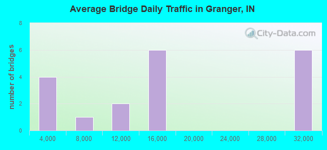
- 289,443Total average daily traffic
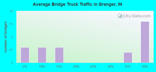
- 81,168Total average daily truck traffic
- National Bridge Inventory (NBI) Registered Bridges for Granger
- No street view available for this location
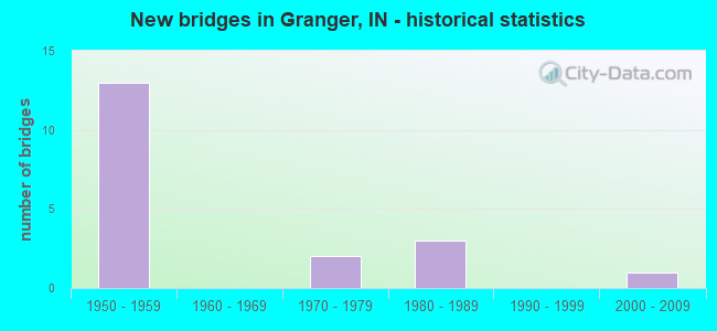
- New bridges - historical statistics
- 131950-1959
- 21970-1979
- 31980-1989
- 12000-2009
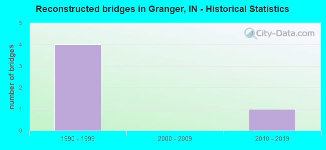
- Reconstructed bridges - Historical Statistics
- 41990-1999
- 02000-2009
- 12010-2019

- Bridge Condition - Deck
- 62.5%Good
- 12.5%Satisfactory
- 25.0%Serious
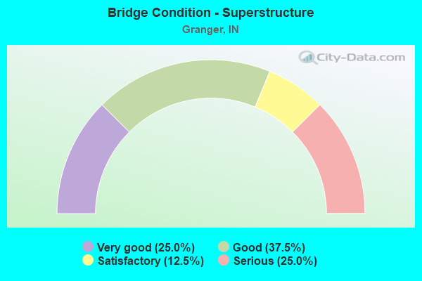
- Bridge Condition - Superstructure
- 25.0%Very good
- 37.5%Good
- 12.5%Satisfactory
- 25.0%Serious
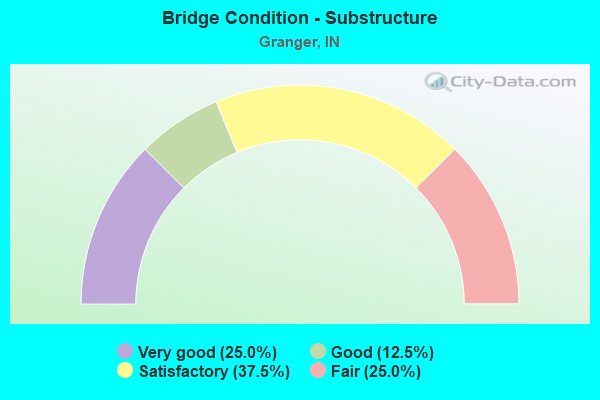
- Bridge Condition - Substructure
- 25.0%Very good
- 12.5%Good
- 37.5%Satisfactory
- 25.0%Fair
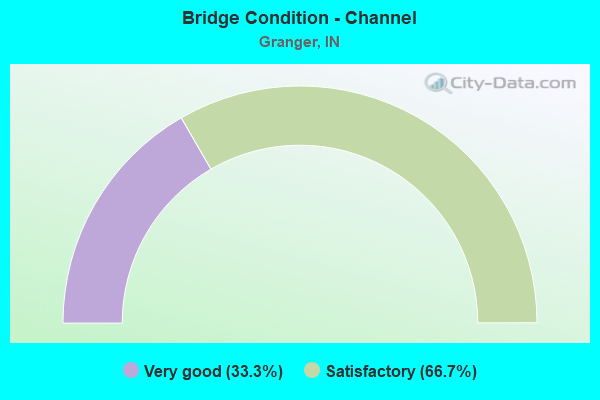
- Bridge Condition - Channel
- 33.3%Very good
- 66.7%Satisfactory
Find on map >> Show street view
Structure Number: 4786, Location: 02.31 E SR 23 (Lat: 41.724311, Lng: -86.154656), Route carried "on" structure: Alternate County highway , Year Built: 1956, Year Reconstructed: 2018, Status: Open, Structure Length: 10.64m (34.91ft), Average Daily Traffic: 9,330 (year 2015), Truck Traffic: 6%, Average Future Daily Traffic: 12,928 (year 2031), Design Load: HS 20+Mod, Features Intersected: I-90 EB/WB, Facility Carried by Structure: CLEVELAND ROAD
Minimum Vertical Clearance: 30+ m (98+ ft), Kilometerpoint: 0.000, Lanes on structure: 2, Lanes under structure: 4, Owner: State Toll Authority, Approaching Roadway Width: 11.0m (36.1ft), Skew: 5 degrees, Material/Design: Steel, Design/Construction: Stringer/Multi-beam, Number Of Spans In Main Unit: 5, Length of Maximum Span: 24.1m (79.1ft), Curb or Sidewalk Widths: Left: 0.2m (0.7ft), Right: 0.2m (0.7ft), Curb-To-Curb Width: 7.9m (25.9ft), Out-to-Out Width: 9.1m (29.9ft)
Condition: Deck: Good, Superstructure: Satisfactory, Substructure: Good, Operating Rating: 79.7 metric tons, Method Used To Determine Operating Rating: Load Factor (LF), Inventory Rating: 47.7 metric tons, Method Used To Determine Inventory Rating: Load Factor (LF), Structural Evaluation: Equal to present minimum criteria, Deck Geometry: High priority of corrective action, Underclear: Somewhat better than minimum adequacy, Approach Roadway Alignment: Equal to present desirable criteria, Designated Inspection Frequency: Every 24 months, Inspection Date: August 2021, Deck Structure Type: Concrete Cast-file-Place, Wearing Surface/Protective System: Wearing Surface: Latex Concrete
Find on map >> Show street view
Structure Number: 47865, Location: 03.18 E SR 23 (Lat: 41.731900, Lng: -86.141350), Route carried "on" structure: Ramp Interstate 90, Year Built: 1982, Status: Open, Structure Length: 7.25m (23.79ft), Average Daily Traffic: 3,850 (year 2015), Truck Traffic: 6%, Average Future Daily Traffic: 1,949 (year 2031), Design Load: HS 20, Features Intersected: I-90 EB/WB
Minimum Vertical Clearance: 30+ m (98+ ft), Kilometerpoint: 133.479, Lanes on structure: 2, Lanes under structure: 5, Base Highway Network: Yes (, Subroute: 1), Toll: On toll road, Owner: State Toll Authority, Approaching Roadway Width: 24.4m (80.1ft), Skew: 31 degrees, Material/Design: Steel continuous, Design/Construction: Stringer/Multi-beam, Number Of Spans In Main Unit: 2, Length of Maximum Span: 38.1m (125.0ft), Curb-To-Curb Width: 18.0m (59.1ft), Out-to-Out Width: 19.0m (62.3ft)
Condition: Deck: Good, Superstructure: Good, Substructure: Satisfactory, Operating Rating: 51.7 metric tons, Method Used To Determine Operating Rating: Load Factor (LF), Inventory Rating: 31.0 metric tons, Method Used To Determine Inventory Rating: Load Factor (LF), Structural Evaluation: Equal to present minimum criteria, Deck Geometry: Superior to present desirable criteria, Underclear: Somewhat better than minimum adequacy, Approach Roadway Alignment: Equal to present desirable criteria, Designated Inspection Frequency: Every 24 months, Inspection Date: August 2021, Deck Structure Type: Concrete Cast-file-Place, Wearing Surface/Protective System: Wearing Surface: Latex Concrete
Find on map >> Show street view
Structure Number: 4787, Location: 03.80 E SR 23 (Lat: 41.733600, Lng: -86.129792), Route carried "on" structure: Interstate 90, Year Built: 1956, Year Reconstructed: 1999, Status: Open, Structure Length: 7.47m (24.51ft), Average Daily Traffic: 14,130 (year 2015), Truck Traffic: 35%, Average Future Daily Traffic: 28,715 (year 2031), Design Load: HS 20, Features Intersected: CURRANT ROAD, GTW RR
Minimum Vertical Clearance: 30+ m (98+ ft), Kilometerpoint: 134.477, Lanes on structure: 2, Lanes under structure: 2, Base Highway Network: Yes (, Subroute: 1), Toll: On toll road, Owner: State Toll Authority, Approaching Roadway Width: 12.8m (42.0ft), Skew: 2 degrees, Material/Design: Steel continuous, Design/Construction: Stringer/Multi-beam, Number Of Spans In Main Unit: 4, Length of Maximum Span: 22.7m (74.5ft), Curb-To-Curb Width: 11.7m (38.4ft), Out-to-Out Width: 12.6m (41.3ft)
Condition: Deck: Good, Superstructure: Very good, Substructure: Very good, Operating Rating: 74.0 metric tons, Method Used To Determine Operating Rating: Load Factor (LF), Inventory Rating: 44.3 metric tons, Method Used To Determine Inventory Rating: Load Factor (LF), Structural Evaluation: Equal to present desirable criteria, Deck Geometry: Equal to present minimum criteria, Underclear: Somewhat better than minimum adequacy, Approach Roadway Alignment: Equal to present desirable criteria, Designated Inspection Frequency: Every 24 months, Inspection Date: August 2021, Deck Structure Type: Concrete Cast-file-Place, Wearing Surface/Protective System: Wearing Surface: Monolithic Concrete, Deck Protection: Epoxy Coated Reinforcing
Find on map >> Show street view
Structure Number: 4788, Location: 03.80 E SR 23 (Lat: 41.733819, Lng: -86.129792), Route carried "on" structure: Interstate 90, Year Built: 1956, Year Reconstructed: 1999, Status: Open, Structure Length: 6.04m (19.82ft), Average Daily Traffic: 14,130 (year 2015), Truck Traffic: 35%, Average Future Daily Traffic: 28,715 (year 2031), Design Load: HS 20, Features Intersected: CURRANT ROAD, GTW RR
Minimum Vertical Clearance: 30+ m (98+ ft), Kilometerpoint: 134.477, Lanes on structure: 2, Lanes under structure: 2, Base Highway Network: Yes (, Subroute: 1), Toll: On toll road, Owner: State Toll Authority, Approaching Roadway Width: 12.8m (42.0ft), Skew: 2 degrees, Material/Design: Steel continuous, Design/Construction: Stringer/Multi-beam, Number Of Spans In Main Unit: 3, Length of Maximum Span: 31.1m (102.0ft), Curb-To-Curb Width: 11.7m (38.4ft), Out-to-Out Width: 12.6m (41.3ft)
Condition: Deck: Good, Superstructure: Very good, Substructure: Very good, Operating Rating: 85.4 metric tons, Method Used To Determine Operating Rating: Load Factor (LF), Inventory Rating: 51.1 metric tons, Method Used To Determine Inventory Rating: Load Factor (LF), Structural Evaluation: Equal to present desirable criteria, Deck Geometry: Equal to present minimum criteria, Underclear: Equal to present minimum criteria, Approach Roadway Alignment: Equal to present desirable criteria, Designated Inspection Frequency: Every 24 months, Inspection Date: August 2021, Deck Structure Type: Concrete Cast-file-Place, Wearing Surface/Protective System: Wearing Surface: Monolithic Concrete, Deck Protection: Epoxy Coated Reinforcing
Find on map >> Show street view
Structure Number: 4789, Location: 04.79 E SR 23 (Lat: 41.733789, Lng: -86.110642), Route carried "on" structure: County highway , Year Built: 1956, Year Reconstructed: 2001, Status: Open, Structure Length: 6.58m (21.59ft), Average Daily Traffic: 7,806 (year 2014), Truck Traffic: 8%, Average Future Daily Traffic: 12,863 (year 2031), Design Load: HS 20, Features Intersected: I-90 EB/WB, Facility Carried by Structure: BITTERSWEET ROAD
Minimum Vertical Clearance: 30+ m (98+ ft), Kilometerpoint: 0.000, Lanes on structure: 2, Lanes under structure: 4, Owner: State Toll Authority, Approaching Roadway Width: 11.0m (36.1ft), Material/Design: Steel, Design/Construction: Stringer/Multi-beam, Number Of Spans In Main Unit: 4, Length of Maximum Span: 20.0m (65.6ft), Curb or Sidewalk Widths: Left: 0.2m (0.7ft), Right: 0.2m (0.7ft), Curb-To-Curb Width: 7.9m (25.9ft), Out-to-Out Width: 9.1m (29.9ft)
Condition: Deck: Satisfactory, Superstructure: Good, Substructure: Satisfactory, Operating Rating: 76.4 metric tons, Method Used To Determine Operating Rating: Load Factor (LF), Inventory Rating: 45.7 metric tons, Method Used To Determine Inventory Rating: Load Factor (LF), Structural Evaluation: Equal to present minimum criteria, Deck Geometry: High priority of corrective action, Underclear: Somewhat better than minimum adequacy, Approach Roadway Alignment: Equal to present desirable criteria, Designated Inspection Frequency: Every 24 months, Inspection Date: August 2021, Deck Structure Type: Concrete Cast-file-Place, Wearing Surface/Protective System: Wearing Surface: Latex Concrete
Find on map >> Show street view
Structure Number: 479, Location: 05.60 W SR 19 (Lat: 41.731281, Lng: -86.081300), Route carried "on" structure: Alternate County highway , Year Built: 1956, Year Reconstructed: 2001, Status: Open, Structure Length: 6.58m (21.59ft), Average Daily Traffic: 1,000 (year 2004), Truck Traffic: 10%, Average Future Daily Traffic: 1,924 (year 2031), Design Load: HS 20, Features Intersected: I-90 EB/WB, Facility Carried by Structure: BEECH ROAD
Minimum Vertical Clearance: 30+ m (98+ ft), Kilometerpoint: 0.000, Lanes on structure: 2, Lanes under structure: 4, Owner: State Toll Authority, Approaching Roadway Width: 11.0m (36.1ft), Material/Design: Steel, Design/Construction: Stringer/Multi-beam, Number Of Spans In Main Unit: 4, Length of Maximum Span: 20.0m (65.6ft), Curb or Sidewalk Widths: Left: 0.2m (0.7ft), Right: 0.2m (0.7ft), Curb-To-Curb Width: 7.9m (25.9ft), Out-to-Out Width: 9.1m (29.9ft)
Condition: Deck: Good, Superstructure: Good, Substructure: Satisfactory, Operating Rating: 68.8 metric tons, Method Used To Determine Operating Rating: Load Factor (LF), Inventory Rating: 41.2 metric tons, Method Used To Determine Inventory Rating: Load Factor (LF), Structural Evaluation: Equal to present minimum criteria, Deck Geometry: Somewhat better than minimum adequacy, Underclear: Somewhat better than minimum adequacy, Approach Roadway Alignment: Equal to present desirable criteria, Designated Inspection Frequency: Every 24 months, Inspection Date: August 2021, Deck Structure Type: Concrete Cast-file-Place, Wearing Surface/Protective System: Wearing Surface: Latex Concrete
Find on map >> Show street view
Structure Number: 7100096, Location: 00.10 N of DOUGLAS Rd (Lat: 41.710811, Lng: -86.216750), Route carried "on" structure: County highway , Year Built: 1979, Status: Posted for load, Structure Length: 0.91m (2.99ft), Average Daily Traffic: 12,798 (year 2020), Truck Traffic: 1%, Average Future Daily Traffic: 21,551 (year 2041), Design Load: HS 20, Features Intersected: JUDAY Creek, Facility Carried by Structure: IRONWOOD Rd
Minimum Vertical Clearance: 30+ m (98+ ft), Kilometerpoint: 0.000, Lanes on structure: 4, Owner: County Highway Agency, Approaching Roadway Width: 17.1m (56.1ft), Skew: 1 degrees, Material/Design: Prestressed concrete, Design/Construction: Box Beam or Girders - Multiple, Number Of Spans In Main Unit: 1, Length of Maximum Span: 7.9m (25.9ft), Curb or Sidewalk Widths: Left: 1.2m (3.9ft), Right: 1.2m (3.9ft), Curb-To-Curb Width: 16.9m (55.4ft), Out-to-Out Width: 19.5m (64.0ft)
Condition: Deck: Serious, Superstructure: Serious, Substructure: Fair, Channel: Satisfactory, Operating Rating: 40.2 metric tons, Method Used To Determine Operating Rating: Load Factor (LF), Inventory Rating: 24.1 metric tons, Method Used To Determine Inventory Rating: Load Factor (LF), Structural Evaluation: High priority of corrective action, Deck Geometry: Somewhat better than minimum adequacy, Waterway Adequacy: Better than present minimum criteria, Approach Roadway Alignment: Equal to present desirable criteria, Length Of Structure Improvement: 1.10m (3.61ft), Designated Inspection Frequency: Every 12 months, Inspection Date: September 2021, Bridge Improvement Cost: $450,000, Roadway Improvement Cost: $278,000, Total Project Cost: $728,000 ( Estimate for 2020), Deck Structure Type: Concrete Precast Panels, Wearing Surface/Protective System: Wearing Surface: Bituminous
Find on map >> Show street view
Structure Number: 7100104, Location: 00.20 E of IRONWOOD Rd (Lat: 41.709061, Lng: -86.213519), Route carried "on" structure: City street , Year Built: 1978, Status: Posted for load, Structure Length: 0.91m (2.99ft), Average Daily Traffic: 11,831 (year 2021), Truck Traffic: 1%, Average Future Daily Traffic: 16,742 (year 2041), Design Load: HS 20, Features Intersected: JUDAY Creek, Facility Carried by Structure: DOUGLAS Rd
Minimum Vertical Clearance: 30+ m (98+ ft), Kilometerpoint: 0.000, Lanes on structure: 2, Owner: County Highway Agency, Approaching Roadway Width: 8.5m (27.9ft), Skew: 3 degrees, Material/Design: Prestressed concrete, Design/Construction: Box Beam or Girders - Multiple, Number Of Spans In Main Unit: 1, Length of Maximum Span: 7.9m (25.9ft), Curb-To-Curb Width: 10.8m (35.4ft), Out-to-Out Width: 11.0m (36.1ft)
Condition: Deck: Serious, Superstructure: Serious, Substructure: Fair, Channel: Satisfactory, Operating Rating: 31.1 metric tons, Method Used To Determine Operating Rating: Load Factor (LF), Inventory Rating: 18.6 metric tons, Method Used To Determine Inventory Rating: Load Factor (LF), Structural Evaluation: High priority of corrective action, Deck Geometry: Meets minimum limits, Waterway Adequacy: Somewhat better than minimum adequacy, Approach Roadway Alignment: Equal to present desirable criteria, Bridge Posting: Required (Relationship of Operating Rating to Maximum Legal Load: 0.1 - 9.9% below), Length Of Structure Improvement: 2.13m (6.99ft), Designated Inspection Frequency: Every 12 months, Inspection Date: September 2021, Bridge Improvement Cost: $708,000, Roadway Improvement Cost: $306,000, Total Project Cost: $1,014,000 ( Estimate for 2020), Deck Structure Type: Concrete Precast Panels, Wearing Surface/Protective System: Wearing Surface: Bituminous
Find on map >> Show street view
Structure Number: 7100129, Location: 00.00 Int of DOUGLAS & FI (Lat: 41.709639, Lng: -86.160700), Route carried "on" structure: Alternate County highway , Year Built: 2006, Status: Open, Structure Length: 1.06m (3.48ft), Average Daily Traffic: 14,492 (year 2019), Truck Traffic: 2%, Average Future Daily Traffic: 31,753 (year 2039), Design Load: HS 20, Features Intersected: JUDAY Creek, Facility Carried by Structure: DOUGLAS Rd
Minimum Vertical Clearance: 30+ m (98+ ft), Kilometerpoint: 0.000, Lanes on structure: 5, Owner: County Highway Agency, Approaching Roadway Width: 22.3m (73.2ft), Skew: 3 degrees, Material/Design: Concrete, Design/Construction: Culvert, Number Of Spans In Main Unit: 1, Length of Maximum Span: 10.6m (34.8ft)
Condition: Channel: Very good, Culverts: Very good, Operating Rating: 32.7 metric tons, Method Used To Determine Operating Rating: Field evaluation and documented engineering judgment, Inventory Rating: 32.7 metric tons, Method Used To Determine Inventory Rating: Field evaluation and documented engineering judgment, Structural Evaluation: Equal to present desirable criteria, Waterway Adequacy: Equal to present desirable criteria, Approach Roadway Alignment: Equal to present desirable criteria, Designated Inspection Frequency: Every 24 months, Inspection Date: September 2020
Find on map >> Show street view
Structure Number: 4786, Location: 02.31 E SR-23 (Lat: 41.724311, Lng: -86.154656), Route carried "under" structure: Interstate 90, Year Built: 1956, Structure Length: 0. m, Average Daily Traffic: 28,960 (year 2015), Truck Traffic: 34%, Features Intersected: I-90 EBL, Facility Carried by Structure: CLEVELAND ROAD
Minimum Vertical Clearance: 4.88m (16.01ft), Kilometerpoint: 132.079, Lanes on structure: 2, Lanes under structure: 4, Material/Design: Steel, Design/Construction: Stringer/Multi-beam, Length of Maximum Span: 24.1m (79.1ft)
Find on map >> Show street view
Structure Number: 4786, Location: 02.31 E SR-23 (Lat: 41.724311, Lng: -86.154656), Route carried "under" structure: Interstate 90, Year Built: 1956, Structure Length: 0. m, Average Daily Traffic: 28,960 (year 2015), Truck Traffic: 34%, Features Intersected: I-90 WBL, Facility Carried by Structure: CLEVELAND ROAD
Minimum Vertical Clearance: 4.88m (16.01ft), Kilometerpoint: 132.079, Lanes on structure: 2, Lanes under structure: 4, Material/Design: Steel, Design/Construction: Stringer/Multi-beam, Length of Maximum Span: 24.1m (79.1ft)
Find on map >> Show street view
Structure Number: 47865, Location: 03.18 E SR 23 (Lat: 41.731900, Lng: -86.141350), Route carried "under" structure: Interstate 90, Year Built: 1982, Structure Length: 0. m, Average Daily Traffic: 28,260 (year 2015), Truck Traffic: 35%, Features Intersected: I-90 EBL
Minimum Vertical Clearance: 4.90m (16.08ft), Kilometerpoint: 133.479, Lanes on structure: 2, Lanes under structure: 5, Toll: On toll road, Material/Design: Steel continuous, Design/Construction: Stringer/Multi-beam, Length of Maximum Span: 38.1m (125.0ft)
Find on map >> Show street view
Structure Number: 47865, Location: 03.18 E SR 23 (Lat: 41.731900, Lng: -86.141350), Route carried "under" structure: Interstate 90, Year Built: 1982, Structure Length: 0. m, Average Daily Traffic: 28,260 (year 2015), Truck Traffic: 35%, Features Intersected: I-90 WBL
Minimum Vertical Clearance: 4.90m (16.08ft), Kilometerpoint: 133.479, Lanes on structure: 2, Lanes under structure: 5, Toll: On toll road, Material/Design: Steel continuous, Design/Construction: Stringer/Multi-beam, Length of Maximum Span: 38.1m (125.0ft)
Find on map >> Show street view
Structure Number: 4787, Location: 03.80 E SR 23 (Lat: 41.733600, Lng: -86.129792), Route carried "under" structure: City street , Year Built: 1956, Structure Length: 0. m, Average Daily Traffic: 428 (year 2004), Truck Traffic: 10%, Features Intersected: CURRANT RD, Facility Carried by Structure: I-90 EB
Minimum Vertical Clearance: 6.86m (22.51ft), Kilometerpoint: 0.000, Lanes on structure: 2, Lanes under structure: 2, Toll: On toll road, Material/Design: Steel continuous, Design/Construction: Stringer/Multi-beam, Length of Maximum Span: 22.7m (74.5ft)
Find on map >> Show street view
Structure Number: 4788, Location: 03.80 E SR 23 (Lat: 41.733819, Lng: -86.129792), Route carried "under" structure: County highway , Year Built: 1956, Structure Length: 0. m, Average Daily Traffic: 428 (year 2004), Truck Traffic: 10%, Features Intersected: CURRANT RD, Facility Carried by Structure: I-90 WB
Minimum Vertical Clearance: 5.63m (18.47ft), Kilometerpoint: 0.000, Lanes on structure: 2, Lanes under structure: 2, Toll: On toll road, Material/Design: Steel continuous, Design/Construction: Stringer/Multi-beam, Length of Maximum Span: 31.1m (102.0ft)
Find on map >> Show street view
Structure Number: 4789, Location: 04.79 E SR 23 (Lat: 41.733789, Lng: -86.110642), Route carried "under" structure: Interstate 90, Year Built: 1956, Structure Length: 0. m, Average Daily Traffic: 14,130 (year 2015), Truck Traffic: 35%, Features Intersected: I-90 EB, Facility Carried by Structure: BITTERSWEET ROAD
Minimum Vertical Clearance: 4.93m (16.17ft), Kilometerpoint: 136.070, Lanes on structure: 2, Lanes under structure: 2, Toll: On toll road, Material/Design: Steel, Design/Construction: Stringer/Multi-beam, Length of Maximum Span: 20.0m (65.6ft)
Find on map >> Show street view
Structure Number: 4789, Location: 04.79 E SR 23 (Lat: 41.733789, Lng: -86.110642), Route carried "under" structure: Interstate 90, Year Built: 1956, Structure Length: 0. m, Average Daily Traffic: 14,130 (year 2015), Truck Traffic: 35%, Features Intersected: I-90 WB, Facility Carried by Structure: BITTERSWEET ROAD
Minimum Vertical Clearance: 4.93m (16.17ft), Kilometerpoint: 136.070, Lanes on structure: 2, Lanes under structure: 2, Toll: On toll road, Material/Design: Steel, Design/Construction: Stringer/Multi-beam, Length of Maximum Span: 20.0m (65.6ft)
Find on map >> Show street view
Structure Number: 479, Location: 05.60 W SR 19 (Lat: 41.731281, Lng: -86.081300), Route carried "under" structure: Interstate 90, Year Built: 1956, Structure Length: 0. m, Average Daily Traffic: 28,260 (year 2015), Truck Traffic: 35%, Features Intersected: I-90 WBL, Facility Carried by Structure: BEECH ROAD
Minimum Vertical Clearance: 4.95m (16.24ft), Kilometerpoint: 138.532, Lanes on structure: 2, Lanes under structure: 4, Material/Design: Steel, Design/Construction: Stringer/Multi-beam, Length of Maximum Span: 20.0m (65.6ft)
Find on map >> Show street view
Structure Number: 479, Location: 05.60 W SR 19 (Lat: 41.731281, Lng: -86.081300), Route carried "under" structure: Interstate 90, Year Built: 1956, Structure Length: 0. m, Average Daily Traffic: 28,260 (year 2015), Truck Traffic: 35%, Features Intersected: I-90 EBL, Facility Carried by Structure: BEECH ROAD
Minimum Vertical Clearance: 4.95m (16.24ft), Kilometerpoint: 138.532, Lanes on structure: 2, Lanes under structure: 4, Material/Design: Steel, Design/Construction: Stringer/Multi-beam, Length of Maximum Span: 20.0m (65.6ft)