Bridge Statistics for Grants Pass, Oregon (OR)
Condition, Traffic, Stress, Structural Evaluation, Project Costs
- National Bridge Inventory (NBI) Statistics
- 43Number of bridges
- 541ft / 165mTotal length
- $11,865,000Total costs
- 625,755Total average daily traffic
- 106,805Total average daily truck traffic
- National Bridge Inventory (NBI) Registered Bridges for Grants Pass
- No street view available for this location
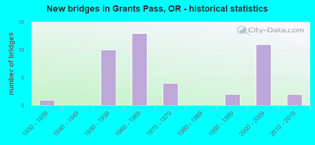
- New bridges - historical statistics
- 11930-1939
- 101950-1959
- 131960-1969
- 41970-1979
- 21990-1999
- 112000-2009
- 22010-2019
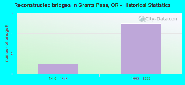
- Reconstructed bridges - Historical Statistics
- 11980-1989
- 51990-1999
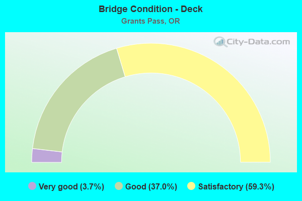
- Bridge Condition - Deck
- 3.7%Very good
- 37.0%Good
- 59.3%Satisfactory
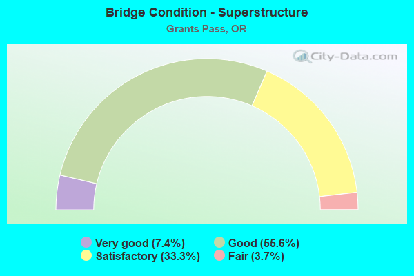
- Bridge Condition - Superstructure
- 7.4%Very good
- 55.6%Good
- 33.3%Satisfactory
- 3.7%Fair
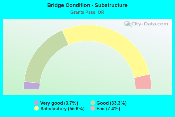
- Bridge Condition - Substructure
- 3.7%Very good
- 33.3%Good
- 55.6%Satisfactory
- 7.4%Fair
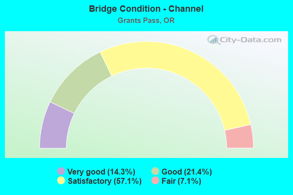
- Bridge Condition - Channel
- 14.3%Very good
- 21.4%Good
- 57.1%Satisfactory
- 7.1%Fair
Find on map >> Show street view
Structure Number: 1418 025X00014, Location: CAVEMAN B 6ST G PASS (Lat: 42.430269, Lng: -123.331631), Route carried "on" structure: US 199, Year Built: 1931, Status: Open, Structure Length: 16.76m (54.99ft), Average Daily Traffic: 20,302 (year 2020), Truck Traffic: 3%, Average Future Daily Traffic: 24,800 (year 2040), Design Load: H 15, Features Intersected: ROGUE RIVER
Minimum Vertical Clearance: 4.67m (15.32ft), Kilometerpoint: 0.225, Lanes on structure: 2, Base Highway Network: Yes, Owner: State Highway Agency, Approaching Roadway Width: 8.2m (26.9ft), Material/Design: Concrete continuous, Design/Construction: Arch - Thru, Number Of Spans In Main Unit: 3, Number Of Approach Spans: 2, Length of Maximum Span: 45.7m (149.9ft), Curb or Sidewalk Widths: Left: 1.5m (4.9ft), Right: 1.5m (4.9ft), Curb-To-Curb Width: 8.2m (26.9ft), Out-to-Out Width: 12.0m (39.4ft)
Condition: Deck: Satisfactory, Superstructure: Satisfactory, Substructure: Fair, Channel: Satisfactory, Operating Rating: 21.7 metric tons, Method Used To Determine Operating Rating: Load and Resistance Factor Rating (LRFR) rating reported by rating factor(RF) method using HL-93 loadings, Inventory Rating: 16.8 metric tons, Method Used To Determine Inventory Rating: Load and Resistance Factor Rating (LRFR) rating reported by rating factor(RF) method using HL-93 loadings, Structural Evaluation: Meets minimum limits, Deck Geometry: High priority of corrective action, Waterway Adequacy: Equal to present desirable criteria, Approach Roadway Alignment: Equal to present desirable criteria, Length Of Structure Improvement: 18.40m (60.37ft), Designated Inspection Frequency: Every 24 months, Underwater Inspection Frequency: Every 24 months, Inspection Date: August 2020, Underwater Inspection Date: July 2021, Bridge Improvement Cost: $1,937,000, Roadway Improvement Cost: $194,000, Total Project Cost: $3,100,000, Deck Structure Type: Concrete Cast-file-Place, Wearing Surface/Protective System: Wearing Surface: Epoxy Overlay
Find on map >> Show street view
Structure Number: 8019A001F06017, Location: 015 MI N G PASS NCL (Lat: 42.477828, Lng: -123.352156), Route carried "on" structure: County highway , Year Built: 1957, Year Reconstructed: 1992, Status: Open, Structure Length: 8.29m (27.20ft), Average Daily Traffic: 900 (year 2010), Truck Traffic: 1%, Average Future Daily Traffic: 1,290 (year 2030), Design Load: HS 20, Features Intersected: I-5 (HWY 001), Facility Carried by Structure: FT RD(HIGHLAND AV)
Minimum Vertical Clearance: 30+ m (98+ ft), Kilometerpoint: 96.834, Lanes on structure: 2, Lanes under structure: 4, Owner: State Highway Agency, Approaching Roadway Width: 7.9m (25.9ft), Skew: 9 degrees, Material/Design: Concrete continuous, Design/Construction: Box Beam or Girders - Multiple, Number Of Spans In Main Unit: 4, Length of Maximum Span: 20.4m (66.9ft), Curb-To-Curb Width: 7.9m (25.9ft), Out-to-Out Width: 9.4m (30.8ft)
Condition: Deck: Satisfactory, Superstructure: Fair, Substructure: Satisfactory, Operating Rating: 39.9 metric tons, Method Used To Determine Operating Rating: Load Factor (LF), Inventory Rating: 23.6 metric tons, Method Used To Determine Inventory Rating: Load Factor (LF), Structural Evaluation: Somewhat better than minimum adequacy, Deck Geometry: Somewhat better than minimum adequacy, Underclear: Meets minimum limits, Approach Roadway Alignment: Equal to present minimum criteria, Length Of Structure Improvement: 9.10m (29.86ft), Designated Inspection Frequency: Every 24 months, Inspection Date: Febuary 2020, Bridge Improvement Cost: $958,000, Roadway Improvement Cost: $96,000, Total Project Cost: $1,533,000, Deck Structure Type: Concrete Cast-file-Place, Wearing Surface/Protective System: Wearing Surface: Latex Concrete
Find on map >> Show street view
Structure Number: 8100 001F06163, Location: 3.2 MI N OF G PASS NCL (Lat: 42.497450, Lng: -123.361911), Route carried "on" structure: County highway , Year Built: 1957, Status: Open, Structure Length: 2.74m (8.99ft), Average Daily Traffic: 4,500 (year 2020), Truck Traffic: 1%, Average Future Daily Traffic: 5,065 (year 2025), Design Load: HS 20, Features Intersected: LOUSE CREEK, Facility Carried by Structure: HIGHLAND AVENUE
Minimum Vertical Clearance: 30+ m (98+ ft), Kilometerpoint: 4.957, Lanes on structure: 2, Owner: County Highway Agency, Approaching Roadway Width: 7.9m (25.9ft), Material/Design: Concrete continuous, Design/Construction: Tee Beam, Number Of Spans In Main Unit: 3, Length of Maximum Span: 11.0m (36.1ft), Curb-To-Curb Width: 7.9m (25.9ft), Out-to-Out Width: 9.4m (30.8ft)
Condition: Deck: Good, Superstructure: Satisfactory, Substructure: Good, Channel: Good, Operating Rating: 35.0 metric tons, Method Used To Determine Operating Rating: Load and Resistance Factor Rating (LRFR) rating reported by rating factor(RF) method using HL-93 loadings, Inventory Rating: 26.9 metric tons, Method Used To Determine Inventory Rating: Load and Resistance Factor Rating (LRFR) rating reported by rating factor(RF) method using HL-93 loadings, Structural Evaluation: Equal to present minimum criteria, Deck Geometry: High priority of corrective action, Waterway Adequacy: Equal to present desirable criteria, Approach Roadway Alignment: Equal to present minimum criteria, Length Of Structure Improvement: 2.70m (8.86ft), Designated Inspection Frequency: Every 24 months, Inspection Date: October 2020, Bridge Improvement Cost: $288,000, Roadway Improvement Cost: $29,000, Total Project Cost: $461,000, Deck Structure Type: Concrete Cast-file-Place, Wearing Surface/Protective System: Wearing Surface: Bituminous
Find on map >> Show street view
Structure Number: 8100A001C06146, Location: 299 MI N OF G PASS (Lat: 42.497281, Lng: -123.362333), Route carried "on" structure: Ramp State highway 5, Year Built: 1972, Status: Open, Structure Length: 2.80m (9.19ft), Average Daily Traffic: 401 (year 2020), Truck Traffic: 19%, Average Future Daily Traffic: 420 (year 2030), Design Load: HS 20, Features Intersected: LOUSE CR
Minimum Vertical Clearance: 30+ m (98+ ft), Kilometerpoint: 98.910, Lanes on structure: 1, Owner: State Highway Agency, Approaching Roadway Width: 7.9m (25.9ft), Material/Design: Prestressed concrete, Design/Construction: Stringer/Multi-beam, Number Of Spans In Main Unit: 1, Length of Maximum Span: 28.0m (91.9ft), Curb-To-Curb Width: 7.9m (25.9ft), Out-to-Out Width: 9.0m (29.5ft)
Condition: Deck: Good, Superstructure: Good, Substructure: Good, Channel: Very good, Operating Rating: 39.9 metric tons, Method Used To Determine Operating Rating: Load and Resistance Factor Rating (LRFR) rating reported by rating factor(RF) method using HL-93 loadings, Inventory Rating: 30.8 metric tons, Method Used To Determine Inventory Rating: Load and Resistance Factor Rating (LRFR) rating reported by rating factor(RF) method using HL-93 loadings, Structural Evaluation: Better than present minimum criteria, Deck Geometry: Equal to present desirable criteria, Waterway Adequacy: Equal to present desirable criteria, Approach Roadway Alignment: Equal to present desirable criteria, Designated Inspection Frequency: Every 24 months, Inspection Date: Febuary 2020, Deck Structure Type: Concrete Cast-file-Place, Wearing Surface/Protective System: Wearing Surface: Bituminous, Membrane: Preformed Fabric
Find on map >> Show street view
Structure Number: 8333 001 0554, Location: 24.9 MI N OF MEDFORD NCL (Lat: 42.437703, Lng: -123.286589), Route carried "on" structure: Interstate 5, Year Built: 1960, Year Reconstructed: 1999, Status: Open, Structure Length: 6.22m (20.41ft), Average Daily Traffic: 26,177 (year 2020), Truck Traffic: 17%, Average Future Daily Traffic: 38,300 (year 2040), Design Load: HS 20, Features Intersected: FOOTHILL BLVD
Minimum Vertical Clearance: 30+ m (98+ ft), Kilometerpoint: 89.158, Lanes on structure: 5, Lanes under structure: 2, Base Highway Network: Yes, Owner: State Highway Agency, Approaching Roadway Width: 27.2m (89.2ft), Skew: 34 degrees, Material/Design: Concrete continuous, Design/Construction: Tee Beam, Number Of Spans In Main Unit: 3, Length of Maximum Span: 24.4m (80.1ft), Curb-To-Curb Width: 27.2m (89.2ft), Out-to-Out Width: 28.7m (94.2ft)
Condition: Deck: Satisfactory, Superstructure: Satisfactory, Substructure: Satisfactory, Operating Rating: 16.8 metric tons, Method Used To Determine Operating Rating: Load and Resistance Factor Rating (LRFR) rating reported by rating factor(RF) method using HL-93 loadings, Inventory Rating: 13.3 metric tons, Method Used To Determine Inventory Rating: Load and Resistance Factor Rating (LRFR) rating reported by rating factor(RF) method using HL-93 loadings, Structural Evaluation: High priority of corrective action, Deck Geometry: Superior to present desirable criteria, Underclear: Somewhat better than minimum adequacy, Approach Roadway Alignment: Equal to present desirable criteria, Designated Inspection Frequency: Every 24 months, Inspection Date: Febuary 2020, Deck Structure Type: Concrete Cast-file-Place, Wearing Surface/Protective System: Wearing Surface: Epoxy Overlay
Find on map >> Show street view
Structure Number: 8335N001 0541, Location: 23.6 MI N MEDFORD NCL (Lat: 42.435431, Lng: -123.261603), Route carried "on" structure: Interstate 5, Year Built: 1960, Year Reconstructed: 1999, Status: Open, Structure Length: 10.39m (34.09ft), Average Daily Traffic: 13,088 (year 2020), Truck Traffic: 17%, Average Future Daily Traffic: 19,150 (year 2040), Design Load: HS 20, Features Intersected: FOOTHILL BLVD
Minimum Vertical Clearance: 30+ m (98+ ft), Kilometerpoint: 87.066, Lanes on structure: 2, Lanes under structure: 2, Base Highway Network: Yes, Owner: State Highway Agency, Approaching Roadway Width: 10.4m (34.1ft), Material/Design: Concrete continuous, Design/Construction: Box Beam or Girders - Multiple, Number Of Spans In Main Unit: 3, Number Of Approach Spans: 3, Length of Maximum Span: 30.5m (100.1ft), Curb-To-Curb Width: 10.4m (34.1ft), Out-to-Out Width: 11.3m (37.1ft)
Condition: Deck: Satisfactory, Superstructure: Satisfactory, Substructure: Satisfactory, Operating Rating: 19.4 metric tons, Method Used To Determine Operating Rating: Load and Resistance Factor Rating (LRFR) rating reported by rating factor(RF) method using HL-93 loadings, Inventory Rating: 14.9 metric tons, Method Used To Determine Inventory Rating: Load and Resistance Factor Rating (LRFR) rating reported by rating factor(RF) method using HL-93 loadings, Structural Evaluation: High priority of corrective action, Deck Geometry: Meets minimum limits, Underclear: Somewhat better than minimum adequacy, Approach Roadway Alignment: Equal to present desirable criteria, Designated Inspection Frequency: Every 24 months, Inspection Date: Febuary 2020, Deck Structure Type: Concrete Cast-file-Place, Wearing Surface/Protective System: Wearing Surface: Latex Concrete
Find on map >> Show street view
Structure Number: 8335S001 0541, Location: 23.6 MI N MEDFORD NCL (Lat: 42.435244, Lng: -123.261489), Route carried "on" structure: Interstate 5, Year Built: 1960, Status: Open, Structure Length: 10.39m (34.09ft), Average Daily Traffic: 13,088 (year 2020), Truck Traffic: 17%, Average Future Daily Traffic: 19,150 (year 2040), Design Load: HS 20, Features Intersected: FOOTHILL BLVD
Minimum Vertical Clearance: 30+ m (98+ ft), Kilometerpoint: 87.066, Lanes on structure: 2, Lanes under structure: 2, Base Highway Network: Yes, Owner: State Highway Agency, Approaching Roadway Width: 10.7m (35.1ft), Material/Design: Concrete continuous, Design/Construction: Box Beam or Girders - Multiple, Number Of Spans In Main Unit: 3, Number Of Approach Spans: 3, Length of Maximum Span: 30.5m (100.1ft), Curb-To-Curb Width: 10.7m (35.1ft), Out-to-Out Width: 11.7m (38.4ft)
Condition: Deck: Satisfactory, Superstructure: Satisfactory, Substructure: Satisfactory, Operating Rating: 29.8 metric tons, Method Used To Determine Operating Rating: Load and Resistance Factor Rating (LRFR) rating reported by rating factor(RF) method using HL-93 loadings, Inventory Rating: 23.0 metric tons, Method Used To Determine Inventory Rating: Load and Resistance Factor Rating (LRFR) rating reported by rating factor(RF) method using HL-93 loadings, Structural Evaluation: Somewhat better than minimum adequacy, Deck Geometry: Meets minimum limits, Underclear: Somewhat better than minimum adequacy, Approach Roadway Alignment: Equal to present desirable criteria, Designated Inspection Frequency: Every 24 months, Inspection Date: Febuary 2020, Deck Structure Type: Concrete Cast-file-Place, Wearing Surface/Protective System: Wearing Surface: Epoxy Overlay
Find on map >> Show street view
Structure Number: 8338 001 0575, Location: .08 MI S OF JCT HWY 25 (Lat: 42.458533, Lng: -123.312311), Route carried "on" structure: Interstate 5, Year Built: 1960, Year Reconstructed: 1999, Status: Open, Structure Length: 5.12m (16.80ft), Average Daily Traffic: 29,317 (year 2020), Truck Traffic: 17%, Average Future Daily Traffic: 39,700 (year 2040), Design Load: HS 20, Features Intersected: HILLCREST DR
Minimum Vertical Clearance: 30+ m (98+ ft), Kilometerpoint: 92.537, Lanes on structure: 4, Lanes under structure: 2, Base Highway Network: Yes, Owner: State Highway Agency, Approaching Roadway Width: 25.4m (83.3ft), Skew: 33 degrees, Material/Design: Concrete continuous, Design/Construction: Tee Beam, Number Of Spans In Main Unit: 3, Length of Maximum Span: 18.3m (60.0ft), Curb-To-Curb Width: 25.4m (83.3ft), Out-to-Out Width: 26.8m (87.9ft)
Condition: Deck: Satisfactory, Superstructure: Satisfactory, Substructure: Satisfactory, Operating Rating: 45.4 metric tons, Method Used To Determine Operating Rating: Load Factor (LF), Inventory Rating: 27.2 metric tons, Method Used To Determine Inventory Rating: Load Factor (LF), Structural Evaluation: Equal to present minimum criteria, Deck Geometry: Superior to present desirable criteria, Underclear: High priority of replacement, Approach Roadway Alignment: Equal to present desirable criteria, Length Of Structure Improvement: 5.60m (18.37ft), Designated Inspection Frequency: Every 24 months, Inspection Date: Febuary 2020, Bridge Improvement Cost: $591,000, Roadway Improvement Cost: $59,000, Total Project Cost: $946,000, Deck Structure Type: Concrete Cast-file-Place, Wearing Surface/Protective System: Wearing Surface: Latex Concrete
Find on map >> Show street view
Structure Number: 8432 025X00024, Location: 7 ST IN GRANTS PASS (Lat: 42.430169, Lng: -123.330131), Route carried "on" structure: US 199, Year Built: 1960, Status: Open, Structure Length: 18.44m (60.50ft), Average Daily Traffic: 20,316 (year 2020), Truck Traffic: 3%, Average Future Daily Traffic: 24,700 (year 2040), Design Load: HS 20, Features Intersected: ROGUE RIVER
Minimum Vertical Clearance: 30+ m (98+ ft), Kilometerpoint: 0.386, Lanes on structure: 2, Lanes under structure: 2, Base Highway Network: Yes, Owner: State Highway Agency, Approaching Roadway Width: 9.1m (29.9ft), Material/Design: Steel continuous, Design/Construction: Stringer/Multi-beam, Number Of Spans In Main Unit: 3, Number Of Approach Spans: 3, Length of Maximum Span: 54.9m (180.1ft), Curb or Sidewalk Widths: Left: 1.5m (4.9ft), Right: 1.5m (4.9ft), Curb-To-Curb Width: 9.1m (29.9ft), Out-to-Out Width: 12.9m (42.3ft)
Condition: Deck: Satisfactory, Superstructure: Satisfactory, Substructure: Satisfactory, Channel: Good, Operating Rating: 24.9 metric tons, Method Used To Determine Operating Rating: Load and Resistance Factor Rating (LRFR) rating reported by rating factor(RF) method using HL-93 loadings, Inventory Rating: 19.4 metric tons, Method Used To Determine Inventory Rating: Load and Resistance Factor Rating (LRFR) rating reported by rating factor(RF) method using HL-93 loadings, Structural Evaluation: Meets minimum limits, Deck Geometry: Meets minimum limits, Underclear: High priority of corrective action, Waterway Adequacy: Superior to present desirable criteria, Approach Roadway Alignment: Equal to present desirable criteria, Length Of Structure Improvement: 18.40m (60.37ft), Designated Inspection Frequency: Every 24 months, Underwater Inspection Frequency: Every 36 months, Inspection Date: August 2020, Underwater Inspection Date: August 2020, Bridge Improvement Cost: $1,937,000, Roadway Improvement Cost: $194,000, Total Project Cost: $3,100,000, Deck Structure Type: Concrete Cast-file-Place, Wearing Surface/Protective System: Wearing Surface: Latex Concrete
Find on map >> Show street view
Structure Number: 8461A060 00021, Location: 00.3 S ROGUE R - HWY 025 (Lat: 42.425272, Lng: -123.329925), Route carried "on" structure: State highway 99, Year Built: 1959, Status: Open, Structure Length: 1.52m (4.99ft), Average Daily Traffic: 5,489 (year 2020), Truck Traffic: 6%, Average Future Daily Traffic: 7,300 (year 2040), Design Load: HS 20, Features Intersected: HWY 025 & 272 NB LEGS
Minimum Vertical Clearance: 30+ m (98+ ft), Kilometerpoint: 0.338, Lanes on structure: 6, Lanes under structure: 2, Base Highway Network: Yes, Owner: State Highway Agency, Approaching Roadway Width: 25.0m (82.0ft), Material/Design: Concrete, Design/Construction: Frame, Number Of Spans In Main Unit: 1, Length of Maximum Span: 15.2m (49.9ft), Curb-To-Curb Width: 25.0m (82.0ft), Out-to-Out Width: 50.9m (167.0ft)
Condition: Deck: Good, Superstructure: Good, Substructure: Satisfactory, Operating Rating: 88.9 metric tons, Method Used To Determine Operating Rating: Load Factor (LF), Inventory Rating: 69.9 metric tons, Method Used To Determine Inventory Rating: Load Factor (LF), Structural Evaluation: Equal to present minimum criteria, Deck Geometry: Somewhat better than minimum adequacy, Underclear: High priority of corrective action, Approach Roadway Alignment: Equal to present desirable criteria, Length Of Structure Improvement: 1.50m (4.92ft), Designated Inspection Frequency: Every 24 months, Inspection Date: December 2021, Bridge Improvement Cost: $160,000, Roadway Improvement Cost: $16,000, Total Project Cost: $256,000, Deck Structure Type: Concrete Cast-file-Place, Wearing Surface/Protective System: Wearing Surface: Bituminous
Find on map >> Show street view
Structure Number: 8461B272 00006, Location: 00.2 S ROGUE R & HWY 025 (Lat: 42.424511, Lng: -123.331939), Route carried "on" structure: State highway 238, Year Built: 1959, Status: Open, Structure Length: 3.05m (10.01ft), Average Daily Traffic: 28,455 (year 2020), Truck Traffic: 5%, Average Future Daily Traffic: 34,900 (year 2040), Design Load: HS 20, Features Intersected: US 199 (HWY 025) NB
Minimum Vertical Clearance: 30+ m (98+ ft), Kilometerpoint: 0.097, Lanes on structure: 4, Lanes under structure: 1, Base Highway Network: Yes, Owner: State Highway Agency, Approaching Roadway Width: 14.6m (47.9ft), Material/Design: Concrete continuous, Design/Construction: Tee Beam, Number Of Spans In Main Unit: 3, Length of Maximum Span: 12.2m (40.0ft), Curb or Sidewalk Widths: Left: 0.0m, Right: 1.5m (4.9ft), Curb-To-Curb Width: 14.6m (47.9ft), Out-to-Out Width: 17.2m (56.4ft)
Condition: Deck: Good, Superstructure: Satisfactory, Substructure: Good, Operating Rating: 39.0 metric tons, Method Used To Determine Operating Rating: Load Factor (LF), Inventory Rating: 23.6 metric tons, Method Used To Determine Inventory Rating: Load Factor (LF), Structural Evaluation: Somewhat better than minimum adequacy, Deck Geometry: High priority of replacement, Underclear: High priority of corrective action, Approach Roadway Alignment: Equal to present desirable criteria, Length Of Structure Improvement: 3.00m (9.84ft), Designated Inspection Frequency: Every 24 months, Inspection Date: October 2021, Bridge Improvement Cost: $320,000, Roadway Improvement Cost: $32,000, Total Project Cost: $512,000, Deck Structure Type: Concrete Cast-file-Place, Wearing Surface/Protective System: Wearing Surface: Bituminous
Find on map >> Show street view
Structure Number: 8500 001 05818, Location: 0.13 MI N OF G PASS SCL (Lat: 42.464600, Lng: -123.322800), Route carried "on" structure: Interstate 5, Year Built: 1959, Year Reconstructed: 1999, Status: Open, Structure Length: 5.79m (19.00ft), Average Daily Traffic: 29,317 (year 2020), Truck Traffic: 17%, Average Future Daily Traffic: 39,700 (year 2040), Design Load: HS 20, Features Intersected: SCOVILLE RD
Minimum Vertical Clearance: 30+ m (98+ ft), Kilometerpoint: 93.632, Lanes on structure: 5, Lanes under structure: 2, Base Highway Network: Yes, Owner: State Highway Agency, Approaching Roadway Width: 26.8m (87.9ft), Skew: 33 degrees, Material/Design: Prestressed concrete, Design/Construction: Stringer/Multi-beam, Number Of Spans In Main Unit: 3, Length of Maximum Span: 23.5m (77.1ft), Curb-To-Curb Width: 26.8m (87.9ft), Out-to-Out Width: 27.7m (90.9ft)
Condition: Deck: Satisfactory, Superstructure: Good, Substructure: Satisfactory, Operating Rating: 36.9 metric tons, Method Used To Determine Operating Rating: Load and Resistance Factor Rating (LRFR) rating reported by rating factor(RF) method using HL-93 loadings, Inventory Rating: 28.5 metric tons, Method Used To Determine Inventory Rating: Load and Resistance Factor Rating (LRFR) rating reported by rating factor(RF) method using HL-93 loadings, Structural Evaluation: Equal to present minimum criteria, Deck Geometry: Superior to present desirable criteria, Underclear: Meets minimum limits, Approach Roadway Alignment: Equal to present desirable criteria, Length Of Structure Improvement: 5.70m (18.70ft), Designated Inspection Frequency: Every 24 months, Inspection Date: Febuary 2020, Bridge Improvement Cost: $602,000, Roadway Improvement Cost: $60,000, Total Project Cost: $963,000, Deck Structure Type: Concrete Cast-file-Place, Wearing Surface/Protective System: Wearing Surface: Latex Concrete
Find on map >> Show street view
Structure Number: 8501 001 05806, Location: 0.11 MI N OF G PASS SCL (Lat: 42.463700, Lng: -123.320800), Route carried "on" structure: Interstate 5, Year Built: 1960, Year Reconstructed: 1999, Status: Open, Structure Length: 5.91m (19.39ft), Average Daily Traffic: 29,317 (year 2020), Truck Traffic: 17%, Average Future Daily Traffic: 39,700 (year 2040), Design Load: HS 20, Features Intersected: US 199, OR 99 (HWY 025)
Minimum Vertical Clearance: 30+ m (98+ ft), Kilometerpoint: 93.439, Lanes on structure: 4, Lanes under structure: 2, Base Highway Network: Yes, Owner: State Highway Agency, Approaching Roadway Width: 23.6m (77.4ft), Skew: 34 degrees, Material/Design: Prestressed concrete, Design/Construction: Stringer/Multi-beam, Number Of Spans In Main Unit: 3, Length of Maximum Span: 21.3m (69.9ft), Curb-To-Curb Width: 23.6m (77.4ft), Out-to-Out Width: 25.0m (82.0ft)
Condition: Deck: Satisfactory, Superstructure: Good, Substructure: Good, Operating Rating: 23.3 metric tons, Method Used To Determine Operating Rating: Load and Resistance Factor Rating (LRFR) rating reported by rating factor(RF) method using HL-93 loadings, Inventory Rating: 18.1 metric tons, Method Used To Determine Inventory Rating: Load and Resistance Factor Rating (LRFR) rating reported by rating factor(RF) method using HL-93 loadings, Structural Evaluation: Meets minimum limits, Deck Geometry: Superior to present desirable criteria, Underclear: Meets minimum limits, Approach Roadway Alignment: Equal to present desirable criteria, Length Of Structure Improvement: 5.90m (19.36ft), Designated Inspection Frequency: Every 24 months, Inspection Date: Febuary 2020, Bridge Improvement Cost: $621,000, Roadway Improvement Cost: $62,000, Total Project Cost: $994,000, Deck Structure Type: Concrete Cast-file-Place, Wearing Surface/Protective System: Wearing Surface: Latex Concrete
Find on map >> Show street view
Structure Number: 16844 025Y00067, Location: 1.5 MI S OF G PASS INTCH (Lat: 42.429400, Lng: -123.318611), Route carried "on" structure: Spur US 199, Year Built: 1990, Status: Open, Structure Length: 14.94m (49.02ft), Average Daily Traffic: 24,780 (year 2020), Truck Traffic: 5%, Average Future Daily Traffic: 31,900 (year 2040), Design Load: HS 25 or greater, Features Intersected: ROGUE RIVER, Facility Carried by Structure: HWY 482 SPUR
Minimum Vertical Clearance: 30+ m (98+ ft), Kilometerpoint: 0.225, Lanes on structure: 4, Base Highway Network: Yes, Owner: State Highway Agency, Approaching Roadway Width: 23.8m (78.1ft), Material/Design: Prestressed concrete continuous, Design/Construction: Box Beam or Girders - Multiple, Number Of Spans In Main Unit: 2, Length of Maximum Span: 74.7m (245.1ft), Curb or Sidewalk Widths: Left: 1.8m (5.9ft), Right: 1.8m (5.9ft), Curb-To-Curb Width: 23.8m (78.1ft), Out-to-Out Width: 28.4m (93.2ft)
Condition: Deck: Satisfactory, Superstructure: Good, Substructure: Good, Channel: Fair, Operating Rating: 45.4 metric tons, Method Used To Determine Operating Rating: Load and Resistance Factor Rating (LRFR) rating reported by rating factor(RF) method using HL-93 loadings, Inventory Rating: 35.0 metric tons, Method Used To Determine Inventory Rating: Load and Resistance Factor Rating (LRFR) rating reported by rating factor(RF) method using HL-93 loadings, Structural Evaluation: Better than present minimum criteria, Deck Geometry: Superior to present desirable criteria, Waterway Adequacy: Equal to present desirable criteria, Approach Roadway Alignment: Equal to present desirable criteria, Designated Inspection Frequency: Every 24 months, Underwater Inspection Frequency: Every 36 months, Inspection Date: August 2020, Underwater Inspection Date: August 2020, Deck Structure Type: Concrete Cast-file-Place, Wearing Surface/Protective System: Wearing Surface: Monolithic Concrete, Deck Protection: Epoxy Coated Reinforcing
Find on map >> Show street view
Structure Number: 16845 025Y00015, Location: 1 MI E OF S G PASS INTCHE (Lat: 42.434619, Lng: -123.312269), Route carried "on" structure: Spur US 199, Year Built: 1990, Status: Open, Structure Length: 8.84m (29.00ft), Average Daily Traffic: 28,776 (year 2020), Truck Traffic: 5%, Average Future Daily Traffic: 36,000 (year 2040), Design Load: HS 25 or greater, Features Intersected: CORP, Facility Carried by Structure: HWY 482 SPUR
Minimum Vertical Clearance: 30+ m (98+ ft), Kilometerpoint: 1.094, Lanes on structure: 4, Base Highway Network: Yes, Owner: State Highway Agency, Approaching Roadway Width: 21.9m (71.9ft), Material/Design: Prestressed concrete, Design/Construction: Stringer/Multi-beam, Number Of Spans In Main Unit: 3, Length of Maximum Span: 39.6m (129.9ft), Curb-To-Curb Width: 21.9m (71.9ft), Out-to-Out Width: 22.8m (74.8ft)
Condition: Deck: Satisfactory, Superstructure: Good, Substructure: Satisfactory, Operating Rating: 25.3 metric tons, Method Used To Determine Operating Rating: Load and Resistance Factor Rating (LRFR) rating reported by rating factor(RF) method using HL-93 loadings, Inventory Rating: 19.4 metric tons, Method Used To Determine Inventory Rating: Load and Resistance Factor Rating (LRFR) rating reported by rating factor(RF) method using HL-93 loadings, Structural Evaluation: Meets minimum limits, Deck Geometry: Superior to present desirable criteria, Underclear: Equal to present minimum criteria, Approach Roadway Alignment: Equal to present desirable criteria, Designated Inspection Frequency: Every 24 months, Inspection Date: August 2020, Deck Structure Type: Concrete Cast-file-Place, Wearing Surface/Protective System: Wearing Surface: Monolithic Concrete, Deck Protection: Epoxy Coated Reinforcing
Find on map >> Show street view
Structure Number: 20459 001 05706, Location: 001 MI FROM GRANTS PASS (Lat: 42.453008, Lng: -123.307800), Route carried "on" structure: Interstate 5, Year Built: 2008, Status: Open, Structure Length: 7.74m (25.39ft), Average Daily Traffic: 14,658 (year 2020), Truck Traffic: 17%, Average Future Daily Traffic: 19,850 (year 2040), Design Load: HL 93, Features Intersected: BEACON DR
Minimum Vertical Clearance: 30+ m (98+ ft), Kilometerpoint: 91.829, Lanes on structure: 2, Lanes under structure: 2, Base Highway Network: Yes, Owner: State Highway Agency, Approaching Roadway Width: 13.4m (44.0ft), Skew: 4 degrees, Material/Design: Prestressed concrete continuous, Design/Construction: Stringer/Multi-beam, Number Of Spans In Main Unit: 3, Length of Maximum Span: 35.4m (116.1ft), Curb-To-Curb Width: 13.4m (44.0ft), Out-to-Out Width: 14.4m (47.2ft)
Condition: Deck: Satisfactory, Superstructure: Good, Substructure: Satisfactory, Operating Rating: 40.2 metric tons, Method Used To Determine Operating Rating: Load and Resistance Factor Rating (LRFR) rating reported by rating factor(RF) method using HL-93 loadings, Inventory Rating: 31.1 metric tons, Method Used To Determine Inventory Rating: Load and Resistance Factor Rating (LRFR) rating reported by rating factor(RF) method using HL-93 loadings, Structural Evaluation: Equal to present minimum criteria, Deck Geometry: Superior to present desirable criteria, Underclear: Meets minimum limits, Approach Roadway Alignment: Equal to present desirable criteria, Designated Inspection Frequency: Every 24 months, Inspection Date: Febuary 2020, Deck Structure Type: Concrete Cast-file-Place, Wearing Surface/Protective System: Wearing Surface: Monolithic Concrete
Find on map >> Show street view
Structure Number: 20460 001 05706, Location: 001 MI FROM GRANTS PASS (Lat: 42.453008, Lng: -123.307800), Route carried "on" structure: Interstate 5, Year Built: 2008, Status: Open, Structure Length: 7.74m (25.39ft), Average Daily Traffic: 14,658 (year 2020), Truck Traffic: 17%, Average Future Daily Traffic: 19,850 (year 2040), Design Load: HL 93, Features Intersected: BEACON DR
Minimum Vertical Clearance: 30+ m (98+ ft), Kilometerpoint: 91.829, Lanes on structure: 2, Lanes under structure: 2, Base Highway Network: Yes, Owner: State Highway Agency, Approaching Roadway Width: 13.4m (44.0ft), Skew: 4 degrees, Material/Design: Prestressed concrete continuous, Design/Construction: Stringer/Multi-beam, Number Of Spans In Main Unit: 3, Length of Maximum Span: 35.4m (116.1ft), Curb-To-Curb Width: 13.4m (44.0ft), Out-to-Out Width: 13.8m (45.3ft)
Condition: Deck: Satisfactory, Superstructure: Very good, Substructure: Satisfactory, Operating Rating: 40.2 metric tons, Method Used To Determine Operating Rating: Load and Resistance Factor Rating (LRFR) rating reported by rating factor(RF) method using HL-93 loadings, Inventory Rating: 31.1 metric tons, Method Used To Determine Inventory Rating: Load and Resistance Factor Rating (LRFR) rating reported by rating factor(RF) method using HL-93 loadings, Structural Evaluation: Equal to present minimum criteria, Deck Geometry: Superior to present desirable criteria, Underclear: Meets minimum limits, Approach Roadway Alignment: Equal to present desirable criteria, Designated Inspection Frequency: Every 24 months, Inspection Date: Febuary 2020, Deck Structure Type: Concrete Cast-file-Place, Wearing Surface/Protective System: Wearing Surface: Monolithic Concrete
Find on map >> Show street view
Structure Number: 20549 001 06145, Location: 3.0 MI N OF G PASS NCL (Lat: 42.497183, Lng: -123.362872), Route carried "on" structure: Interstate 5, Year Built: 2008, Status: Open, Structure Length: 5.61m (18.41ft), Average Daily Traffic: 10,726 (year 2020), Truck Traffic: 34%, Average Future Daily Traffic: 15,100 (year 2040), Design Load: HL 93, Features Intersected: LOUSE CR, FRONTAGE RD
Minimum Vertical Clearance: 30+ m (98+ ft), Kilometerpoint: 98.894, Lanes on structure: 2, Lanes under structure: 2, Base Highway Network: Yes, Owner: State Highway Agency, Approaching Roadway Width: 12.8m (42.0ft), Material/Design: Prestressed concrete, Design/Construction: Box Beam or Girders - Multiple, Number Of Spans In Main Unit: 2, Length of Maximum Span: 28.0m (91.9ft), Curb-To-Curb Width: 12.8m (42.0ft), Out-to-Out Width: 13.8m (45.3ft)
Condition: Deck: Satisfactory, Superstructure: Good, Substructure: Good, Channel: Very good, Operating Rating: 66.4 metric tons, Method Used To Determine Operating Rating: Load and Resistance Factor Rating (LRFR) rating reported by rating factor(RF) method using HL-93 loadings, Inventory Rating: 51.2 metric tons, Method Used To Determine Inventory Rating: Load and Resistance Factor Rating (LRFR) rating reported by rating factor(RF) method using HL-93 loadings, Structural Evaluation: Better than present minimum criteria, Deck Geometry: Equal to present desirable criteria, Underclear: High priority of corrective action, Waterway Adequacy: Equal to present desirable criteria, Approach Roadway Alignment: Equal to present desirable criteria, Designated Inspection Frequency: Every 24 months, Inspection Date: Febuary 2020, Deck Structure Type: Concrete Cast-file-Place, Wearing Surface/Protective System: Wearing Surface: Monolithic Concrete, Deck Protection: Epoxy Coated Reinforcing
Find on map >> Show street view
Structure Number: 20550 001 06145, Location: 3.0 MI N OF G PASS NCL (Lat: 42.497133, Lng: -123.363286), Route carried "on" structure: Interstate 5, Year Built: 2008, Status: Open, Structure Length: 5.61m (18.41ft), Average Daily Traffic: 10,726 (year 2020), Truck Traffic: 34%, Average Future Daily Traffic: 15,100 (year 2040), Design Load: HL 93, Features Intersected: LOUSE CR, FRONTAGE RD
Minimum Vertical Clearance: 30+ m (98+ ft), Kilometerpoint: 98.894, Lanes on structure: 2, Lanes under structure: 2, Base Highway Network: Yes, Owner: State Highway Agency, Approaching Roadway Width: 12.8m (42.0ft), Skew: 8 degrees, Material/Design: Prestressed concrete, Design/Construction: Box Beam or Girders - Multiple, Number Of Spans In Main Unit: 2, Length of Maximum Span: 28.0m (91.9ft), Curb-To-Curb Width: 12.8m (42.0ft), Out-to-Out Width: 13.8m (45.3ft)
Condition: Deck: Satisfactory, Superstructure: Good, Substructure: Good, Channel: Good, Operating Rating: 66.4 metric tons, Method Used To Determine Operating Rating: Load and Resistance Factor Rating (LRFR) rating reported by rating factor(RF) method using HL-93 loadings, Inventory Rating: 51.2 metric tons, Method Used To Determine Inventory Rating: Load and Resistance Factor Rating (LRFR) rating reported by rating factor(RF) method using HL-93 loadings, Structural Evaluation: Better than present minimum criteria, Deck Geometry: Equal to present desirable criteria, Underclear: High priority of corrective action, Waterway Adequacy: Equal to present desirable criteria, Approach Roadway Alignment: Equal to present desirable criteria, Designated Inspection Frequency: Every 24 months, Inspection Date: Febuary 2020, Deck Structure Type: Concrete Cast-file-Place, Wearing Surface/Protective System: Wearing Surface: Monolithic Concrete, Deck Protection: Epoxy Coated Reinforcing
Find on map >> Show street view
Structure Number: 20551 001 05578, Location: 25.3 MI N OF MEDFORD NCL (Lat: 42.438114, Lng: -123.294019), Route carried "on" structure: Interstate 5, Year Built: 2008, Status: Open, Structure Length: 8.84m (29.00ft), Average Daily Traffic: 26,177 (year 2020), Truck Traffic: 17%, Average Future Daily Traffic: 38,300 (year 2040), Design Load: HL 93, Features Intersected: HWY 482 SPUR
Minimum Vertical Clearance: 30+ m (98+ ft), Kilometerpoint: 89.769, Lanes on structure: 5, Lanes under structure: 2, Base Highway Network: Yes, Owner: State Highway Agency, Approaching Roadway Width: 29.2m (95.8ft), Skew: 34 degrees, Material/Design: Prestressed concrete continuous, Design/Construction: Box Beam or Girders - Single/Spread, Number Of Spans In Main Unit: 3, Length of Maximum Span: 39.6m (129.9ft), Curb-To-Curb Width: 29.2m (95.8ft), Out-to-Out Width: 30.9m (101.4ft)
Condition: Deck: Satisfactory, Superstructure: Satisfactory, Substructure: Satisfactory, Operating Rating: 53.8 metric tons, Method Used To Determine Operating Rating: Load and Resistance Factor Rating (LRFR) rating reported by rating factor(RF) method using HL-93 loadings, Inventory Rating: 41.5 metric tons, Method Used To Determine Inventory Rating: Load and Resistance Factor Rating (LRFR) rating reported by rating factor(RF) method using HL-93 loadings, Structural Evaluation: Equal to present minimum criteria, Deck Geometry: Superior to present desirable criteria, Underclear: Somewhat better than minimum adequacy, Approach Roadway Alignment: Equal to present desirable criteria, Designated Inspection Frequency: Every 24 months, Inspection Date: Febuary 2020, Deck Structure Type: Concrete Cast-file-Place, Wearing Surface/Protective System: Wearing Surface: Monolithic Concrete, Deck Protection: Epoxy Coated Reinforcing
Find on map >> Show street view
Structure Number: 20723 250000077, Location: 0.68 MI E OF AGNESS RD (Lat: 42.437319, Lng: -123.288033), Route carried "on" structure: County highway C2500, Year Built: 2008, Status: Open, Structure Length: 1.68m (5.51ft), Average Daily Traffic: 7,139 (year 2020), Truck Traffic: 10%, Average Future Daily Traffic: 7,889 (year 2025), Design Load: HL 93, Features Intersected: JONES CREEK, Facility Carried by Structure: FOOTHILL BLVD.
Minimum Vertical Clearance: 30+ m (98+ ft), Kilometerpoint: 1.159, Lanes on structure: 2, Owner: County Highway Agency, Approaching Roadway Width: 12.5m (41.0ft), Skew: 3 degrees, Material/Design: Prestressed concrete, Design/Construction: Slab, Number Of Spans In Main Unit: 1, Length of Maximum Span: 16.8m (55.1ft), Curb-To-Curb Width: 12.5m (41.0ft), Out-to-Out Width: 13.5m (44.3ft)
Condition: Deck: Good, Superstructure: Good, Substructure: Good, Channel: Satisfactory, Operating Rating: 83.5 metric tons, Method Used To Determine Operating Rating: Load Factor (LF), Inventory Rating: 49.9 metric tons, Method Used To Determine Inventory Rating: Load Factor (LF), Structural Evaluation: Better than present minimum criteria, Deck Geometry: Somewhat better than minimum adequacy, Waterway Adequacy: Equal to present desirable criteria, Approach Roadway Alignment: Equal to present desirable criteria, Designated Inspection Frequency: Every 24 months, Inspection Date: October 2020, Deck Structure Type: Concrete Precast Panels, Wearing Surface/Protective System: Wearing Surface: Bituminous, Deck Protection: Epoxy Coated Reinforcing
Find on map >> Show street view
Structure Number: 22628, Location: SOUTH OF REDWOOD AVE. AND (Lat: 42.418700, Lng: -123.385600), Route carried "on" structure: City street , Year Built: 2016, Status: Open, Structure Length: 1.30m (4.27ft), Average Daily Traffic: 150 (year 2020), Truck Traffic: 1%, Average Future Daily Traffic: 175 (year 2025), Design Load: HL 93, Features Intersected: Sand Creek, Facility Carried by Structure: Elmer Nelson Way
Minimum Vertical Clearance: 30+ m (98+ ft), Kilometerpoint: 0.000, Lanes on structure: 2, Owner: City or Municipal Highway Agency, Approaching Roadway Width: 9.8m (32.2ft), Skew: 2 degrees, Material/Design: Prestressed concrete, Design/Construction: Slab, Number Of Spans In Main Unit: 1, Length of Maximum Span: 12.2m (40.0ft), Curb or Sidewalk Widths: Left: 1.4m (4.6ft), Right: 1.4m (4.6ft), Curb-To-Curb Width: 9.8m (32.2ft), Out-to-Out Width: 13.4m (44.0ft)
Condition: Deck: Very good, Superstructure: Very good, Substructure: Satisfactory, Channel: Satisfactory, Operating Rating: 53.1 metric tons, Method Used To Determine Operating Rating: Load and Resistance Factor Rating (LRFR) rating reported by rating factor(RF) method using HL-93 loadings, Inventory Rating: 41.1 metric tons, Method Used To Determine Inventory Rating: Load and Resistance Factor Rating (LRFR) rating reported by rating factor(RF) method using HL-93 loadings, Structural Evaluation: Equal to present minimum criteria, Deck Geometry: Better than present minimum criteria, Waterway Adequacy: Equal to present desirable criteria, Approach Roadway Alignment: Equal to present desirable criteria, Designated Inspection Frequency: Every 24 months, Inspection Date: October 2020, Deck Structure Type: Concrete Cast-file-Place, Wearing Surface/Protective System: Wearing Surface: Bituminous
Find on map >> Show street view
Structure Number: 22629, Location: 0.03 Mi E. NW Prosp Ave. (Lat: 42.451200, Lng: -123.329500), Route carried "on" structure: City street , Year Built: 2016, Status: Open, Structure Length: 1.23m (4.04ft), Average Daily Traffic: 124 (year 2020), Truck Traffic: 1%, Average Future Daily Traffic: 134 (year 2025), Design Load: HL 93, Features Intersected: Gilbert Creek, Facility Carried by Structure: NW Savage St.
Minimum Vertical Clearance: 30+ m (98+ ft), Kilometerpoint: 0.000, Lanes on structure: 2, Owner: City or Municipal Highway Agency, Approaching Roadway Width: 11.0m (36.1ft), Material/Design: Prestressed concrete, Design/Construction: Slab, Number Of Spans In Main Unit: 1, Length of Maximum Span: 11.3m (37.1ft), Curb or Sidewalk Widths: Left: 1.7m (5.6ft), Right: 1.7m (5.6ft), Curb-To-Curb Width: 11.0m (36.1ft), Out-to-Out Width: 14.9m (48.9ft)
Condition: Deck: Good, Superstructure: Good, Substructure: Very good, Channel: Satisfactory, Operating Rating: 89.7 metric tons, Method Used To Determine Operating Rating: Load and Resistance Factor Rating (LRFR) rating reported by rating factor(RF) method using HL-93 loadings, Inventory Rating: 69.0 metric tons, Method Used To Determine Inventory Rating: Load and Resistance Factor Rating (LRFR) rating reported by rating factor(RF) method using HL-93 loadings, Structural Evaluation: Better than present minimum criteria, Deck Geometry: Equal to present desirable criteria, Waterway Adequacy: Equal to present desirable criteria, Approach Roadway Alignment: Equal to present desirable criteria, Designated Inspection Frequency: Every 24 months, Inspection Date: October 2020, Deck Structure Type: Concrete Cast-file-Place, Wearing Surface/Protective System: Wearing Surface: Bituminous, Membrane: Preformed Fabric
Find on map >> Show street view
Structure Number: 23530523530001, Location: T35S-R5W-S25 JOSEPHINE CO (Lat: 42.495942, Lng: -123.352381), Route carried "on" structure: County highway C2353, Year Built: 1973, Status: Open, Structure Length: 0.91m (2.99ft), Average Daily Traffic: 71 (year 2020), Average Future Daily Traffic: 86 (year 2025), Design Load: HS 20, Features Intersected: LOUSE CREEK, Facility Carried by Structure: SOLDIER CREEK ROAD
Minimum Vertical Clearance: 30+ m (98+ ft), Kilometerpoint: 0.097, Lanes on structure: 2, Owner: County Highway Agency, Approaching Roadway Width: 9.4m (30.8ft), Material/Design: Prestressed concrete, Design/Construction: Slab, Number Of Spans In Main Unit: 1, Length of Maximum Span: 8.2m (26.9ft), Curb-To-Curb Width: 9.6m (31.5ft), Out-to-Out Width: 9.8m (32.2ft)
Condition: Deck: Good, Superstructure: Good, Substructure: Fair, Channel: Satisfactory, Operating Rating: 47.2 metric tons, Method Used To Determine Operating Rating: Load Factor (LF), Inventory Rating: 28.1 metric tons, Method Used To Determine Inventory Rating: Load Factor (LF), Structural Evaluation: Somewhat better than minimum adequacy, Deck Geometry: Better than present minimum criteria, Waterway Adequacy: Equal to present minimum criteria, Approach Roadway Alignment: Equal to present desirable criteria, Designated Inspection Frequency: Every 24 months, Inspection Date: October 2020, Deck Structure Type: Other, Wearing Surface/Protective System: Wearing Surface: Bituminous
Find on map >> Show street view
Structure Number: 320010320000089, Location: T36S-R5W-S29 JOSEPHINE CO (Lat: 42.411903, Lng: -123.309800), Route carried "on" structure: County highway C3200, Year Built: 1966, Status: Open, Structure Length: 0.79m (2.59ft), Average Daily Traffic: 5,391 (year 2020), Truck Traffic: 10%, Average Future Daily Traffic: 6,141 (year 2025), Design Load: HS 20, Features Intersected: SOUTH HIGHLINE CANAL, Facility Carried by Structure: CLOVERLAWN DRIVE
Minimum Vertical Clearance: 30+ m (98+ ft), Kilometerpoint: 1.336, Lanes on structure: 2, Owner: County Highway Agency, Approaching Roadway Width: 8.8m (28.9ft), Skew: 1 degrees, Material/Design: Prestressed concrete, Design/Construction: Slab, Number Of Spans In Main Unit: 1, Length of Maximum Span: 7.3m (24.0ft), Curb-To-Curb Width: 8.8m (28.9ft), Out-to-Out Width: 9.8m (32.2ft)
Condition: Deck: Good, Superstructure: Good, Substructure: Satisfactory, Channel: Satisfactory, Operating Rating: 46.0 metric tons, Method Used To Determine Operating Rating: Load and Resistance Factor Rating (LRFR) rating reported by rating factor(RF) method using HL-93 loadings, Inventory Rating: 27.9 metric tons, Method Used To Determine Inventory Rating: Load and Resistance Factor Rating (LRFR) rating reported by rating factor(RF) method using HL-93 loadings, Structural Evaluation: Equal to present minimum criteria, Deck Geometry: High priority of replacement, Waterway Adequacy: Equal to present desirable criteria, Approach Roadway Alignment: Equal to present desirable criteria, Designated Inspection Frequency: Every 24 months, Underwater Inspection Frequency: Every 60 months, Inspection Date: October 2020, Underwater Inspection Date: September 2021, Deck Structure Type: Other, Wearing Surface/Protective System: Wearing Surface: Bituminous
Find on map >> Show street view
Structure Number: 33C33 230000272, Location: T35S-R5W-S29 JOSEPHINE CO (Lat: 42.502697, Lng: -123.322347), Route carried "on" structure: County highway A3350, Year Built: 1975, Status: Open, Structure Length: 1.28m (4.20ft), Average Daily Traffic: 984 (year 2020), Truck Traffic: 10%, Average Future Daily Traffic: 1,159 (year 2025), Design Load: HS 20, Features Intersected: LOUSE CREEK, Facility Carried by Structure: GRANITE HILL ROAD
Minimum Vertical Clearance: 30+ m (98+ ft), Kilometerpoint: 4.216, Lanes on structure: 2, Owner: County Highway Agency, Approaching Roadway Width: 9.1m (29.9ft), Skew: 4 degrees, Material/Design: Prestressed concrete, Design/Construction: Slab, Number Of Spans In Main Unit: 1, Length of Maximum Span: 11.9m (39.0ft), Curb or Sidewalk Widths: Left: 0.2m (0.7ft), Right: 0.2m (0.7ft), Curb-To-Curb Width: 8.8m (28.9ft), Out-to-Out Width: 9.7m (31.8ft)
Condition: Deck: Good, Superstructure: Good, Substructure: Satisfactory, Channel: Satisfactory, Operating Rating: 54.4 metric tons, Method Used To Determine Operating Rating: Load Factor (LF), Inventory Rating: 32.7 metric tons, Method Used To Determine Inventory Rating: Load Factor (LF), Structural Evaluation: Equal to present minimum criteria, Deck Geometry: Somewhat better than minimum adequacy, Waterway Adequacy: Equal to present desirable criteria, Approach Roadway Alignment: Equal to present minimum criteria, Designated Inspection Frequency: Every 24 months, Inspection Date: October 2020, Deck Structure Type: Other, Wearing Surface/Protective System: Wearing Surface: Bituminous
Find on map >> Show street view
Structure Number: 35120535120001, Location: JOSEPHINE CO (Lat: 42.425400, Lng: -123.339900), Route carried "on" structure: County highway C3512, Year Built: 1971, Status: Open, Structure Length: 0.76m (2.49ft), Average Daily Traffic: 1,067 (year 2020), Truck Traffic: 10%, Average Future Daily Traffic: 1,242 (year 2025), Design Load: HS 20, Features Intersected: IRRIGATION CANAL, Facility Carried by Structure: RINGUETTE STREET
Minimum Vertical Clearance: 30+ m (98+ ft), Kilometerpoint: 0.193, Lanes on structure: 2, Owner: County Highway Agency, Approaching Roadway Width: 11.0m (36.1ft), Skew: 2 degrees, Material/Design: Prestressed concrete, Design/Construction: Slab, Number Of Spans In Main Unit: 1, Length of Maximum Span: 7.3m (24.0ft), Curb-To-Curb Width: 11.1m (36.4ft), Out-to-Out Width: 11.9m (39.0ft)
Condition: Deck: Good, Superstructure: Good, Substructure: Good, Channel: Satisfactory, Operating Rating: 44.5 metric tons, Method Used To Determine Operating Rating: Allowable Stress (AS), Inventory Rating: 27.2 metric tons, Method Used To Determine Inventory Rating: Allowable Stress (AS), Structural Evaluation: Equal to present minimum criteria, Deck Geometry: Equal to present minimum criteria, Waterway Adequacy: High priority of corrective action, Approach Roadway Alignment: Equal to present desirable criteria, Designated Inspection Frequency: Every 24 months, Inspection Date: October 2020, Deck Structure Type: Concrete Precast Panels, Wearing Surface/Protective System: Wearing Surface: Bituminous
Find on map >> Show street view
Structure Number: 8019A001F06017, Location: 015 MI N G PASS NCL (Lat: 42.477828, Lng: -123.352156), Route carried "under" structure: Interstate 5, Year Built: 1957, Structure Length: 0. m, Average Daily Traffic: 21,452 (year 2020), Truck Traffic: 34%, Features Intersected: I-5 (HWY 001), Facility Carried by Structure: FT RD(HIGHLAND AV)
Minimum Vertical Clearance: 5.82m (19.09ft), Kilometerpoint: 96.834, Lanes on structure: 2, Lanes under structure: 4, Material/Design: Concrete continuous, Design/Construction: Box Beam or Girders - Multiple, Length of Maximum Span: 20.4m (66.9ft)
Find on map >> Show street view
Structure Number: 8333 001 0554, Location: 24.9 MI N OF MEDFORD NCL (Lat: 42.437703, Lng: -123.286589), Route carried "under" structure: County highway , Year Built: 1960, Structure Length: 0. m, Average Daily Traffic: 28,100 (year 2010), Truck Traffic: 28%, Features Intersected: FOOTHILL BLVD, Facility Carried by Structure: I-5 (HWY 001)
Minimum Vertical Clearance: 5.11m (16.77ft), Kilometerpoint: 0.000, Lanes on structure: 5, Lanes under structure: 2, Material/Design: Concrete continuous, Design/Construction: Tee Beam, Length of Maximum Span: 24.4m (80.1ft)
Find on map >> Show street view
Structure Number: 8335N001 0541, Location: 23.6 MI N MEDFORD NCL (Lat: 42.435431, Lng: -123.261603), Route carried "under" structure: County highway , Year Built: 1960, Structure Length: 0. m, Average Daily Traffic: 900 (year 2010), Truck Traffic: 5%, Features Intersected: FOOTHILL BLVD, Facility Carried by Structure: I-5 (HWY 001) NB
Minimum Vertical Clearance: 7.42m (24.34ft), Kilometerpoint: 0.000, Lanes on structure: 2, Lanes under structure: 2, Material/Design: Concrete continuous, Design/Construction: Box Beam or Girders - Multiple, Length of Maximum Span: 30.5m (100.1ft)
Find on map >> Show street view
Structure Number: 8335S001 0541, Location: 23.6 MI N MEDFORD NCL (Lat: 42.435244, Lng: -123.261489), Route carried "under" structure: County highway , Year Built: 1960, Structure Length: 0. m, Average Daily Traffic: 900 (year 2010), Truck Traffic: 5%, Features Intersected: FOOTHILL BLVD, Facility Carried by Structure: I-5 (HWY 001) SB
Minimum Vertical Clearance: 7.42m (24.34ft), Kilometerpoint: 0.000, Lanes on structure: 2, Lanes under structure: 2, Material/Design: Concrete continuous, Design/Construction: Box Beam or Girders - Multiple, Length of Maximum Span: 30.5m (100.1ft)
Find on map >> Show street view
Structure Number: 8338 001 0575, Location: .08 MI S OF JCT HWY 25 (Lat: 42.458533, Lng: -123.312311), Route carried "under" structure: City street , Year Built: 1960, Structure Length: 0. m, Average Daily Traffic: 22,800 (year 2010), Truck Traffic: 28%, Features Intersected: HILLCREST DR, Facility Carried by Structure: I-5 (HWY 001)
Minimum Vertical Clearance: 5.23m (17.16ft), Kilometerpoint: 0.000, Lanes on structure: 4, Lanes under structure: 2, Material/Design: Concrete continuous, Design/Construction: Tee Beam, Length of Maximum Span: 18.3m (60.0ft)
Find on map >> Show street view
Structure Number: 8432 025X00024, Location: 7 ST IN GRANTS PASS (Lat: 42.430169, Lng: -123.330131), Route carried "under" structure: ServiceCity street , Year Built: 1960, Structure Length: 0. m, Average Daily Traffic: 18,600 (year 2010), Features Intersected: ROGUE RIVER, Facility Carried by Structure: US199 (HWY 025)NB
Minimum Vertical Clearance: 3.66m (12.01ft), Kilometerpoint: 0.386, Lanes on structure: 2, Lanes under structure: 2, Material/Design: Steel continuous, Design/Construction: Stringer/Multi-beam, Length of Maximum Span: 54.9m (180.1ft)
Find on map >> Show street view
Structure Number: 8461A060 00021, Location: 00.3 S ROGUE R - HWY 025 (Lat: 42.425272, Lng: -123.329925), Route carried "under" structure: State highway 238, Year Built: 1959, Structure Length: 0. m, Average Daily Traffic: 8,532 (year 2020), Truck Traffic: 5%, Features Intersected: HWY 025 & 272 NB LEGS, Facility Carried by Structure: OR 99 (HWY 060)
Minimum Vertical Clearance: 4.57m (14.99ft), Kilometerpoint: 0.338, Lanes on structure: 6, Lanes under structure: 1, Material/Design: Concrete, Design/Construction: Frame, Length of Maximum Span: 15.2m (49.9ft)
Find on map >> Show street view
Structure Number: 8461A060 00021, Location: 00.3 S ROGUE R - HWY 025 (Lat: 42.425272, Lng: -123.329925), Route carried "under" structure: State highway 199, Year Built: 1959, Structure Length: 0. m, Average Daily Traffic: 32,044 (year 2020), Truck Traffic: 18%, Features Intersected: HWY 025 & 272 NB LEGS, Facility Carried by Structure: OR 99 (HWY 060)
Minimum Vertical Clearance: 5.21m (17.09ft), Kilometerpoint: 0.338, Lanes on structure: 6, Lanes under structure: 1, Material/Design: Concrete, Design/Construction: Frame, Length of Maximum Span: 15.2m (49.9ft)
Find on map >> Show street view
Structure Number: 8461B272 00006, Location: 00.2 S ROGUE R & HWY 025 (Lat: 42.424511, Lng: -123.331939), Route carried "under" structure: US 199, Year Built: 1959, Structure Length: 0. m, Average Daily Traffic: 32,044 (year 2020), Truck Traffic: 18%, Features Intersected: US 199 (HWY 025) NB, Facility Carried by Structure: OR 238 (HWY 272)
Minimum Vertical Clearance: 4.72m (15.49ft), Kilometerpoint: 0.354, Lanes on structure: 4, Lanes under structure: 1, Material/Design: Concrete continuous, Design/Construction: Tee Beam, Length of Maximum Span: 12.2m (40.0ft)
Find on map >> Show street view
Structure Number: 8500 001 05818, Location: 0.13 MI N OF G PASS SCL (Lat: 42.464600, Lng: -123.322800), Route carried "under" structure: City street , Year Built: 1959, Structure Length: 0. m, Average Daily Traffic: 31,100 (year 2010), Truck Traffic: 28%, Features Intersected: SCOVILLE RD, Facility Carried by Structure: I-5 (HWY 001)
Minimum Vertical Clearance: 5.00m (16.40ft), Kilometerpoint: 0.000, Lanes on structure: 5, Lanes under structure: 2, Material/Design: Prestressed concrete, Design/Construction: Stringer/Multi-beam, Length of Maximum Span: 23.5m (77.1ft)
Find on map >> Show street view
Structure Number: 8501 001 05806, Location: 0.11 MI N OF G PASS SCL (Lat: 42.463700, Lng: -123.320800), Route carried "under" structure: Ramp State highway 99, Year Built: 1960, Structure Length: 0. m, Average Daily Traffic: 6,350 (year 2020), Truck Traffic: 3%, Features Intersected: US 199, OR 99 (HWY 025), Facility Carried by Structure: I-5 (HWY 001)
Minimum Vertical Clearance: 5.00m (16.40ft), Kilometerpoint: 0.000, Lanes on structure: 4, Lanes under structure: 2, Material/Design: Prestressed concrete, Design/Construction: Stringer/Multi-beam, Length of Maximum Span: 21.3m (69.9ft)
Find on map >> Show street view
Structure Number: 20459 001 05706, Location: 001 MI FROM GRANTS PASS (Lat: 42.453008, Lng: -123.307800), Route carried "under" structure: City street , Year Built: 2008, Structure Length: 0. m, Average Daily Traffic: 100 (year 2010), Features Intersected: BEACON DR, Facility Carried by Structure: I-5 (HWY 001)
Minimum Vertical Clearance: 4.80m (15.75ft), Kilometerpoint: 0.000, Lanes on structure: 2, Lanes under structure: 2, Material/Design: Prestressed concrete continuous, Design/Construction: Stringer/Multi-beam, Length of Maximum Span: 35.4m (116.1ft)
Find on map >> Show street view
Structure Number: 20460 001 05706, Location: 001 MI FROM GRANTS PASS (Lat: 42.453008, Lng: -123.307800), Route carried "under" structure: City street , Year Built: 2008, Structure Length: 0. m, Average Daily Traffic: 100 (year 2010), Features Intersected: BEACON DR, Facility Carried by Structure: I-5 (HWY 001)
Minimum Vertical Clearance: 4.80m (15.75ft), Kilometerpoint: 0.000, Lanes on structure: 2, Lanes under structure: 2, Material/Design: Prestressed concrete continuous, Design/Construction: Stringer/Multi-beam, Length of Maximum Span: 35.4m (116.1ft)
Find on map >> Show street view
Structure Number: 20549 001 06145, Location: 3.0 MI N OF G PASS NCL (Lat: 42.497183, Lng: -123.362872), Route carried "under" structure: ServiceInterstate 5, Year Built: 2008, Structure Length: 0. m, Average Daily Traffic: 7,087 (year 2020), Truck Traffic: 19%, Features Intersected: LOUSE CR, FRONTAGE RD
Minimum Vertical Clearance: 5.33m (17.49ft), Kilometerpoint: 99.586, Lanes on structure: 2, Lanes under structure: 2, Material/Design: Prestressed concrete, Design/Construction: Box Beam or Girders - Multiple, Length of Maximum Span: 28.0m (91.9ft)
Find on map >> Show street view
Structure Number: 20550 001 06145, Location: 3.0 MI N OF G PASS NCL (Lat: 42.497133, Lng: -123.363286), Route carried "under" structure: ServiceInterstate 5, Year Built: 2008, Structure Length: 0. m, Average Daily Traffic: 21,452 (year 2020), Truck Traffic: 34%, Features Intersected: LOUSE CR, FRONTAGE RD
Minimum Vertical Clearance: 30.45m (99.90ft), Kilometerpoint: 99.586, Lanes on structure: 2, Lanes under structure: 2, Material/Design: Prestressed concrete, Design/Construction: Box Beam or Girders - Multiple, Length of Maximum Span: 28.0m (91.9ft)
Find on map >> Show street view
Structure Number: 20551 001 05578, Location: 25.3 MI N OF MEDFORD NCL (Lat: 42.438114, Lng: -123.294019), Route carried "under" structure: US , Year Built: 2008, Structure Length: 0. m, Average Daily Traffic: 28,100 (year 2010), Truck Traffic: 28%, Features Intersected: HWY 482 SPUR, Facility Carried by Structure: I-5 (HWY 001)
Minimum Vertical Clearance: 5.33m (17.49ft), Kilometerpoint: 2.784, Lanes on structure: 5, Lanes under structure: 2, Material/Design: Prestressed concrete continuous, Design/Construction: Box Beam or Girders - Single/Spread, Length of Maximum Span: 39.6m (129.9ft)