Bridge Statistics for Gray, Maine (ME)
Condition, Traffic, Stress, Structural Evaluation, Project Costs
- National Bridge Inventory (NBI) Statistics
- 12Number of bridges
- 72ft / 21.8mTotal length
- 1,468,611Total average daily traffic
- 73,430Total average daily truck traffic
- 94,524Total future (year 2036) average daily traffic
- National Bridge Inventory (NBI) Registered Bridges for Gray
- No street view available for this location
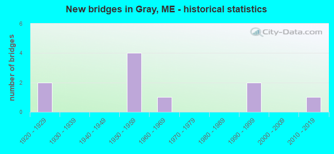
- New bridges - historical statistics
- 21920-1929
- 41950-1959
- 11960-1969
- 21990-1999
- 12010-2019

- Reconstructed bridges - Historical Statistics
- 21980-1989
- 11990-1999
- 12000-2009


- Bridge Condition - Deck
- 57.1%Good
- 42.9%Fair

- Bridge Condition - Superstructure
- 28.6%Good
- 28.6%Satisfactory
- 42.9%Fair

- Bridge Condition - Substructure
- 42.9%Good
- 28.6%Satisfactory
- 14.3%Fair
- 14.3%Poor

- Bridge Condition - Channel
- 10.0%Very good
- 20.0%Good
- 30.0%Satisfactory
- 40.0%Fair

- Bridge Condition - Culverts
- 20.0%Very good
- 40.0%Good
- 20.0%Satisfactory
- 20.0%Fair
Find on map >> Show street view
Location: 0.5 MI NW RT 4 (Lat: 86.334542, Lng: -511.601947), Route carried "under" structure: Spur US 71500, Year Built: 3030, Status: Open, Structure Length: 1.10m (3.61ft), Average Daily Traffic: 902,000 (year 0165), Truck Traffic: 5%, Average Future Daily Traffic: 2,477 (year 2036), Design Load: H 10, Features Intersected: 28870COLLYER BROOK, Facility Carried by Structure: WEYMOUTH RD
Lanes on structure: 92, Toll: , Approaching Roadway Width: 201.60m (661.42ft), Material/Design: Concrete, Design/Construction: Culvert, Number Of Spans In Main Unit: 3, Length of Maximum Span: 3.7m (12.1ft)
Condition: Channel: Very good, Culverts: Very good, Operating Rating: 8.4 metric tons, Method Used To Determine Operating Rating: Load and Resistance Factor Rating (LRFR) rating reported by rating factor(RF) method using HL-93 loadings, Inventory Rating: 6.5 metric tons, Method Used To Determine Inventory Rating: Load and Resistance Factor Rating (LRFR) rating reported by rating factor(RF) method using HL-93 loadings, Structural Evaluation: High priority of corrective action, Waterway Adequacy: Equal to present minimum criteria, Approach Roadway Alignment: Equal to present desirable criteria, Designated Inspection Frequency: Every 24 months, Inspection Date: October 2021
Find on map >> Show street view
Location: .6 MI SE RTE 202 (Lat: 88.334542, Lng: -122.351950), Route carried "under" structure: US 31500, Year Built: 3030, Status: Open, Structure Length: 0.87m (2.85ft), Average Daily Traffic: 502,000 (year 0090), Truck Traffic: 5%, Average Future Daily Traffic: 1,445 (year 2036), Design Load: HS 15, Features Intersected: 28870PLEASANT RIVER, Facility Carried by Structure: LAWRENCE RD
Lanes on structure: 92, Lanes under structure: 1, Toll: , Owner: Town or Township Highway Agency, Approaching Roadway Width: 201.60m (661.42ft), Material/Design: Aluminum, Iron, Design/Construction: Culvert, Number Of Spans In Main Unit: 1, Length of Maximum Span: 8.7m (28.5ft)
Condition: Channel: Fair, Culverts: Good, Operating Rating: 77.8 metric tons, Method Used To Determine Operating Rating: Load and Resistance Factor Rating (LRFR) rating reported by rating factor(RF) method using HL-93 loadings, Inventory Rating: 59.9 metric tons, Method Used To Determine Inventory Rating: Load and Resistance Factor Rating (LRFR) rating reported by rating factor(RF) method using HL-93 loadings, Structural Evaluation: Better than present minimum criteria, Waterway Adequacy: Equal to present minimum criteria, Approach Roadway Alignment: Equal to present minimum criteria, Designated Inspection Frequency: Every 24 months, Inspection Date: April 2021
Find on map >> Show street view
Structure Number: 149, Location: 0.070 mi W or SR 100&26 (Lat: 43.849731, Lng: -70.323239), Route carried "on" structure: Interstate 95, Year Built: 1956, Year Reconstructed: 1991, Status: Open, Structure Length: 2.96m (9.71ft), Average Daily Traffic: 14,400 (year 2016), Truck Traffic: 5%, Average Future Daily Traffic: 20,160 (year 2036), Design Load: HL 93, Features Intersected: EAGLES NEST ROAD
Minimum Vertical Clearance: 30+ m (98+ ft), Kilometerpoint: 391.281, Lanes on structure: 2, Lanes under structure: 2, Base Highway Network: Yes, Toll: On Interstate toll segment, Owner: State Toll Authority, Approaching Roadway Width: 9.8m (32.2ft), Material/Design: Steel continuous, Design/Construction: Stringer/Multi-beam, Number Of Spans In Main Unit: 3, Length of Maximum Span: 11.9m (39.0ft), Curb or Sidewalk Widths: Left: 0.2m (0.7ft), Right: 0.2m (0.7ft), Curb-To-Curb Width: 9.8m (32.2ft), Out-to-Out Width: 10.9m (35.8ft)
Condition: Deck: Good, Superstructure: Good, Substructure: Good, Operating Rating: 41.1 metric tons, Method Used To Determine Operating Rating: Load and Resistance Factor Rating (LRFR) rating reported by rating factor(RF) method using HL-93 loadings, Inventory Rating: 31.8 metric tons, Method Used To Determine Inventory Rating: Load and Resistance Factor Rating (LRFR) rating reported by rating factor(RF) method using HL-93 loadings, Structural Evaluation: Better than present minimum criteria, Deck Geometry: High priority of replacement, Underclear: Meets minimum limits, Approach Roadway Alignment: Equal to present desirable criteria, Designated Inspection Frequency: Every 24 months, Inspection Date: May 2021, Deck Structure Type: Concrete Cast-file-Place, Wearing Surface/Protective System: Wearing Surface: Bituminous, Membrane: Epoxy, Deck Protection: Epoxy Coated Reinforcing
Find on map >> Show street view
Structure Number: 2386, Location: 1.2 MI S OF JCT ROUTE 115 (Lat: 43.870911, Lng: -70.325961), Route carried "on" structure: State highway 26, Year Built: 1922, Status: Open, Structure Length: 0.73m (2.40ft), Average Daily Traffic: 6,340 (year 2016), Truck Traffic: 5%, Average Future Daily Traffic: 8,876 (year 2036), Design Load: H 20, Features Intersected: PLEASANT RIVER
Minimum Vertical Clearance: 30+ m (98+ ft), Kilometerpoint: 24.784, Lanes on structure: 2, Base Highway Network: Yes, Owner: State Highway Agency, Approaching Roadway Width: 9.8m (32.2ft), Material/Design: Concrete, Design/Construction: Frame, Number Of Spans In Main Unit: 1, Length of Maximum Span: 6.1m (20.0ft), Curb or Sidewalk Widths: Left: 0.2m (0.7ft), Right: 0.2m (0.7ft), Curb-To-Curb Width: 9.8m (32.2ft), Out-to-Out Width: 10.7m (35.1ft)
Condition: Deck: Fair, Superstructure: Fair, Substructure: Satisfactory, Channel: Fair, Operating Rating: 48.0 metric tons, Method Used To Determine Operating Rating: Load and Resistance Factor Rating (LRFR) rating reported by rating factor(RF) method using HL-93 loadings, Inventory Rating: 36.9 metric tons, Method Used To Determine Inventory Rating: Load and Resistance Factor Rating (LRFR) rating reported by rating factor(RF) method using HL-93 loadings, Structural Evaluation: Somewhat better than minimum adequacy, Deck Geometry: Meets minimum limits, Waterway Adequacy: Equal to present desirable criteria, Approach Roadway Alignment: Equal to present desirable criteria, Designated Inspection Frequency: Every 24 months, Inspection Date: October 2021, Deck Structure Type: Concrete Cast-file-Place, Wearing Surface/Protective System: Wearing Surface: Bituminous
Find on map >> Show street view
Structure Number: 25, Location: 0.2 MI E OF JCT RTE 11 (Lat: 47.251889, Lng: -68.593189), Route carried "on" structure: State highway 1, Year Built: 1953, Year Reconstructed: 1989, Status: Open, Structure Length: 6.42m (21.06ft), Average Daily Traffic: 8,100 (year 2016), Truck Traffic: 5%, Average Future Daily Traffic: 11,340 (year 2036), Design Load: H 20, Features Intersected: FISH RIVER
Minimum Vertical Clearance: 30+ m (98+ ft), Kilometerpoint: 845.728, Lanes on structure: 2, Base Highway Network: Yes, Owner: State Highway Agency, Approaching Roadway Width: 13.4m (44.0ft), Material/Design: Steel, Design/Construction: Stringer/Multi-beam, Number Of Spans In Main Unit: 3, Length of Maximum Span: 22.9m (75.1ft), Curb or Sidewalk Widths: Left: 1.5m (4.9ft), Right: 1.5m (4.9ft), Curb-To-Curb Width: 8.5m (27.9ft), Out-to-Out Width: 12.2m (40.0ft)
Condition: Deck: Fair, Superstructure: Fair, Substructure: Fair, Channel: Fair, Operating Rating: 42.8 metric tons, Method Used To Determine Operating Rating: Load and Resistance Factor Rating (LRFR) rating reported by rating factor(RF) method using HL-93 loadings, Inventory Rating: 33.0 metric tons, Method Used To Determine Inventory Rating: Load and Resistance Factor Rating (LRFR) rating reported by rating factor(RF) method using HL-93 loadings, Structural Evaluation: Somewhat better than minimum adequacy, Deck Geometry: Meets minimum limits, Waterway Adequacy: Somewhat better than minimum adequacy, Approach Roadway Alignment: Equal to present desirable criteria, Designated Inspection Frequency: Every 24 months, Underwater Inspection Frequency: Every 60 months, Inspection Date: September 2021, Underwater Inspection Date: July 2020, Deck Structure Type: Concrete Cast-file-Place, Wearing Surface/Protective System: Wearing Surface: Integral Concrete, Membrane: Built-up
Find on map >> Show street view
Structure Number: 2618, Location: 0.7MI S OF NEW GLOUCESTER (Lat: 43.918200, Lng: -70.316961), Route carried "on" structure: State highway 202, Year Built: 1922, Status: Open, Structure Length: 0.98m (3.22ft), Average Daily Traffic: 10,140 (year 2016), Truck Traffic: 5%, Average Future Daily Traffic: 14,196 (year 2036), Design Load: H 20, Features Intersected: COLLYER BROOK
Minimum Vertical Clearance: 30+ m (98+ ft), Kilometerpoint: 95.177, Lanes on structure: 2, Base Highway Network: Yes, Owner: State Highway Agency, Approaching Roadway Width: 10.4m (34.1ft), Material/Design: Concrete, Design/Construction: Tee Beam, Number Of Spans In Main Unit: 1, Length of Maximum Span: 7.7m (25.3ft), Curb or Sidewalk Widths: Left: 0.2m (0.7ft), Right: 0.2m (0.7ft), Curb-To-Curb Width: 9.9m (32.5ft), Out-to-Out Width: 10.8m (35.4ft)
Condition: Deck: Fair, Superstructure: Fair, Substructure: Poor, Channel: Good, Operating Rating: 24.3 metric tons, Method Used To Determine Operating Rating: Load and Resistance Factor Rating (LRFR) rating reported by rating factor(RF) method using HL-93 loadings, Inventory Rating: 18.8 metric tons, Method Used To Determine Inventory Rating: Load and Resistance Factor Rating (LRFR) rating reported by rating factor(RF) method using HL-93 loadings, Structural Evaluation: Meets minimum limits, Deck Geometry: Meets minimum limits, Waterway Adequacy: Equal to present desirable criteria, Approach Roadway Alignment: Equal to present desirable criteria, Designated Inspection Frequency: Every 24 months, Inspection Date: April 2021, Deck Structure Type: Concrete Cast-file-Place, Wearing Surface/Protective System: Wearing Surface: Bituminous
Find on map >> Show street view
Structure Number: 287, Location: 1.3 MI W OF JCT US2 & 17 (Lat: 44.575350, Lng: -70.323269), Route carried "on" structure: State highway 2, Year Built: 1991, Status: Open, Structure Length: 1.16m (3.81ft), Average Daily Traffic: 3,767 (year 2016), Truck Traffic: 5%, Average Future Daily Traffic: 5,274 (year 2036), Design Load: HS 25 or greater, Features Intersected: SEVEN MILE STREAM
Minimum Vertical Clearance: 30+ m (98+ ft), Kilometerpoint: 82.656, Lanes on structure: 2, Base Highway Network: Yes, Owner: State Highway Agency, Approaching Roadway Width: 11.0m (36.1ft), Skew: 4 degrees, Material/Design: Concrete, Design/Construction: Culvert, Number Of Spans In Main Unit: 1, Length of Maximum Span: 10.3m (33.8ft)
Condition: Channel: Good, Culverts: Satisfactory, Operating Rating: 43.7 metric tons, Method Used To Determine Operating Rating: Load and Resistance Factor Rating (LRFR) rating reported by rating factor(RF) method using HL-93 loadings, Inventory Rating: 34.0 metric tons, Method Used To Determine Inventory Rating: Load and Resistance Factor Rating (LRFR) rating reported by rating factor(RF) method using HL-93 loadings, Structural Evaluation: Equal to present minimum criteria, Waterway Adequacy: Superior to present desirable criteria, Approach Roadway Alignment: Equal to present desirable criteria, Designated Inspection Frequency: Every 24 months, Inspection Date: August 2021
Find on map >> Show street view
Structure Number: 291, Location: 0.8 MI W OF JCT RTE 17 (Lat: 44.574861, Lng: -70.313539), Route carried "on" structure: State highway 2, Year Built: 1991, Status: Open, Structure Length: 1.16m (3.81ft), Average Daily Traffic: 3,662 (year 2016), Truck Traffic: 5%, Average Future Daily Traffic: 5,127 (year 2036), Design Load: HS 25 or greater, Features Intersected: SEVEN MILE STREAM
Minimum Vertical Clearance: 30+ m (98+ ft), Kilometerpoint: 83.364, Lanes on structure: 2, Base Highway Network: Yes, Owner: State Highway Agency, Approaching Roadway Width: 12.2m (40.0ft), Skew: 4 degrees, Material/Design: Concrete, Design/Construction: Frame, Number Of Spans In Main Unit: 1, Length of Maximum Span: 10.3m (33.8ft), Curb or Sidewalk Widths: Left: 0.1m (0.3ft), Right: 0.1m (0.3ft), Curb-To-Curb Width: 12.8m (42.0ft), Out-to-Out Width: 13.7m (44.9ft)
Condition: Deck: Good, Superstructure: Good, Substructure: Good, Channel: Satisfactory, Operating Rating: 51.2 metric tons, Method Used To Determine Operating Rating: Load and Resistance Factor Rating (LRFR) rating reported by rating factor(RF) method using HL-93 loadings, Inventory Rating: 39.5 metric tons, Method Used To Determine Inventory Rating: Load and Resistance Factor Rating (LRFR) rating reported by rating factor(RF) method using HL-93 loadings, Structural Evaluation: Better than present minimum criteria, Deck Geometry: Equal to present minimum criteria, Waterway Adequacy: Superior to present desirable criteria, Approach Roadway Alignment: Equal to present desirable criteria, Designated Inspection Frequency: Every 24 months, Inspection Date: October 2021, Deck Structure Type: Concrete Cast-file-Place, Wearing Surface/Protective System: Wearing Surface: Bituminous, Membrane: Preformed Fabric
Find on map >> Show street view
Structure Number: 375, Location: 1.4 MI S RTES 202/4/1153 (Lat: 43.865831, Lng: -70.338039), Route carried "on" structure: City street , Year Built: 2012, Status: Open, Structure Length: 0.66m (2.17ft), Average Daily Traffic: 1,300 (year 2016), Truck Traffic: 5%, Average Future Daily Traffic: 1,950 (year 2036), Design Load: HS 25 or greater, Features Intersected: PLEASANT RIVER, Facility Carried by Structure: CENTER RD
Minimum Vertical Clearance: 30+ m (98+ ft), Kilometerpoint: 5.423, Lanes on structure: 2, Owner: Town or Township Highway Agency, Approaching Roadway Width: 6.7m (22.0ft), Material/Design: Aluminum, Iron, Design/Construction: Culvert, Number Of Spans In Main Unit: 1, Length of Maximum Span: 6.6m (21.7ft)
Condition: Channel: Satisfactory, Culverts: Good, Operating Rating: 37.0 metric tons, Method Used To Determine Operating Rating: Load Factor (LF), Inventory Rating: 29.7 metric tons, Method Used To Determine Inventory Rating: Load Factor (LF), Structural Evaluation: Better than present minimum criteria, Waterway Adequacy: Equal to present minimum criteria, Approach Roadway Alignment: Equal to present desirable criteria, Designated Inspection Frequency: Every 24 months, Inspection Date: August 2021
Find on map >> Show street view
Structure Number: 529, Location: 3.2 MI S OF JCT RTE 10 (Lat: 46.599800, Lng: -67.934619), Route carried "on" structure: City street , Year Built: 1951, Status: Open, Structure Length: 0.84m (2.76ft), Average Daily Traffic: 80 (year 2016), Truck Traffic: 5%, Average Future Daily Traffic: 128 (year 2036), Design Load: H 15, Features Intersected: CLARK BROOK, Facility Carried by Structure: EGYPT ROAD
Minimum Vertical Clearance: 30+ m (98+ ft), Kilometerpoint: 4.603, Lanes on structure: 2, Owner: State Highway Agency, Approaching Roadway Width: 7.3m (24.0ft), Material/Design: Steel, Design/Construction: Culvert, Number Of Spans In Main Unit: 2, Length of Maximum Span: 3.6m (11.8ft)
Condition: Channel: Satisfactory, Culverts: Fair, Operating Rating: 97.2 metric tons, Method Used To Determine Operating Rating: Load and Resistance Factor Rating (LRFR) rating reported by rating factor(RF) method using HL-93 loadings, Inventory Rating: 97.2 metric tons, Method Used To Determine Inventory Rating: Load and Resistance Factor Rating (LRFR) rating reported by rating factor(RF) method using HL-93 loadings, Structural Evaluation: Somewhat better than minimum adequacy, Waterway Adequacy: Equal to present desirable criteria, Approach Roadway Alignment: Equal to present minimum criteria, Designated Inspection Frequency: Every 24 months, Inspection Date: October 2020
Find on map >> Show street view
Structure Number: 5781, Location: 1.0 MI W NEW GLOUCESTER (Lat: 43.890931, Lng: -70.277219), Route carried "on" structure: County highway , Year Built: 1963, Year Reconstructed: 2011, Status: Open, Structure Length: 2.67m (8.76ft), Average Daily Traffic: 2,422 (year 2016), Truck Traffic: 5%, Average Future Daily Traffic: 3,391 (year 2036), Design Load: H 20, Features Intersected: ROYAL RIVER, Facility Carried by Structure: DEPOT ROAD
Minimum Vertical Clearance: 30+ m (98+ ft), Kilometerpoint: 2.575, Lanes on structure: 2, Owner: State Highway Agency, Approaching Roadway Width: 9.8m (32.2ft), Skew: 2 degrees, Material/Design: Steel, Design/Construction: Stringer/Multi-beam, Number Of Spans In Main Unit: 1, Length of Maximum Span: 25.9m (85.0ft), Curb-To-Curb Width: 9.1m (29.9ft), Out-to-Out Width: 10.1m (33.1ft)
Condition: Deck: Good, Superstructure: Satisfactory, Substructure: Satisfactory, Channel: Fair, Operating Rating: 63.2 metric tons, Method Used To Determine Operating Rating: Load and Resistance Factor Rating (LRFR) rating reported by rating factor(RF) method using HL-93 loadings, Inventory Rating: 48.6 metric tons, Method Used To Determine Inventory Rating: Load and Resistance Factor Rating (LRFR) rating reported by rating factor(RF) method using HL-93 loadings, Structural Evaluation: Equal to present minimum criteria, Deck Geometry: Meets minimum limits, Waterway Adequacy: Equal to present desirable criteria, Approach Roadway Alignment: Equal to present minimum criteria, Designated Inspection Frequency: Every 24 months, Inspection Date: October 2021, Deck Structure Type: Concrete Cast-file-Place, Wearing Surface/Protective System: Wearing Surface: Integral Concrete
Find on map >> Show street view
Structure Number: 6493, Location: .092 mi W of SR 100 (Lat: 43.861619, Lng: -70.324731), Route carried "on" structure: Interstate 95, Year Built: 1956, Year Reconstructed: 1999, Status: Open, Structure Length: 2.29m (7.51ft), Average Daily Traffic: 14,400 (year 2016), Truck Traffic: 5%, Average Future Daily Traffic: 20,160 (year 2036), Design Load: HL 93, Features Intersected: HUNTS HILL ROAD
Minimum Vertical Clearance: 30+ m (98+ ft), Kilometerpoint: 0.000, Lanes on structure: 2, Lanes under structure: 2, Toll: On Interstate toll segment, Owner: State Toll Authority, Approaching Roadway Width: 11.6m (38.1ft), Skew: 3 degrees, Material/Design: Steel, Design/Construction: Stringer/Multi-beam, Number Of Spans In Main Unit: 1, Length of Maximum Span: 22.9m (75.1ft), Curb-To-Curb Width: 11.6m (38.1ft), Out-to-Out Width: 12.5m (41.0ft)
Condition: Deck: Good, Superstructure: Satisfactory, Substructure: Good, Operating Rating: 61.2 metric tons, Method Used To Determine Operating Rating: Load and Resistance Factor Rating (LRFR) rating reported by rating factor(RF) method using HL-93 loadings, Inventory Rating: 47.3 metric tons, Method Used To Determine Inventory Rating: Load and Resistance Factor Rating (LRFR) rating reported by rating factor(RF) method using HL-93 loadings, Structural Evaluation: Equal to present minimum criteria, Deck Geometry: Equal to present minimum criteria, Underclear: Meets minimum limits, Approach Roadway Alignment: Equal to present desirable criteria, Designated Inspection Frequency: Every 24 months, Inspection Date: May 2021, Deck Structure Type: Concrete Cast-file-Place, Wearing Surface/Protective System: Wearing Surface: Bituminous, Membrane: Preformed Fabric, Deck Protection: Epoxy Coated Reinforcing