Bridge Statistics for Greater Carrollwood, Florida (FL)
Condition, Traffic, Stress, Structural Evaluation, Project Costs
- National Bridge Inventory (NBI) Statistics
- 13Number of bridges
- 141ft / 43.0mTotal length
- 273,466Total average daily traffic
- 12,126Total average daily truck traffic
- National Bridge Inventory (NBI) Registered Bridges for Greater Carrollwood
- No street view available for this location
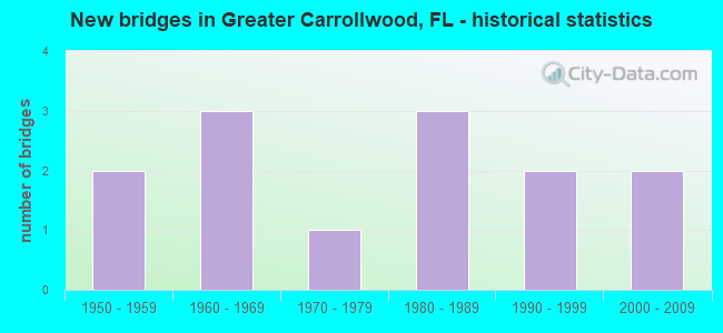
- New bridges - historical statistics
- 21950-1959
- 31960-1969
- 11970-1979
- 31980-1989
- 21990-1999
- 22000-2009

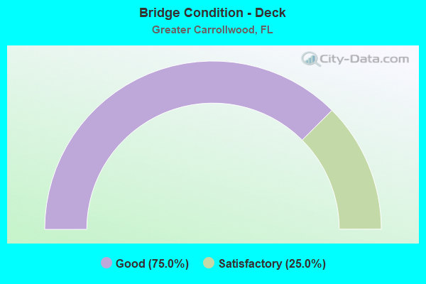
- Bridge Condition - Deck
- 75.0%Good
- 25.0%Satisfactory
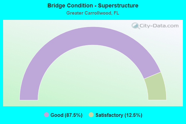
- Bridge Condition - Superstructure
- 87.5%Good
- 12.5%Satisfactory
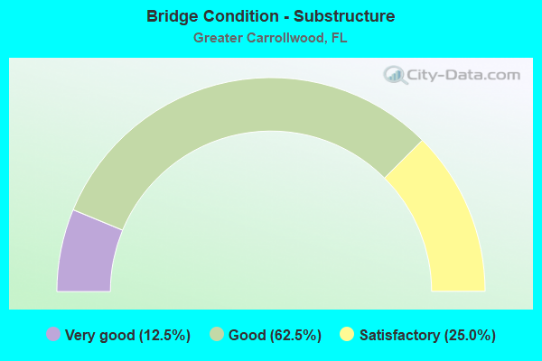
- Bridge Condition - Substructure
- 12.5%Very good
- 62.5%Good
- 25.0%Satisfactory
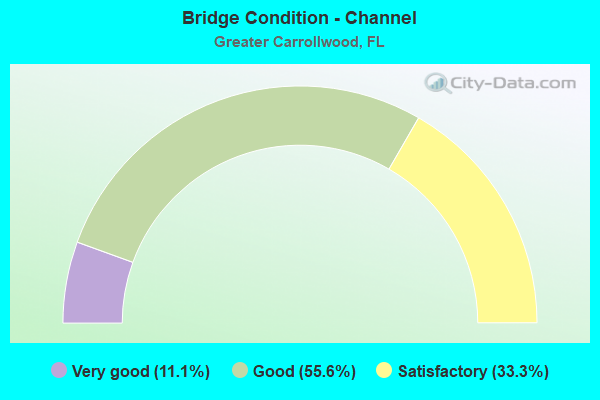
- Bridge Condition - Channel
- 11.1%Very good
- 55.6%Good
- 33.3%Satisfactory
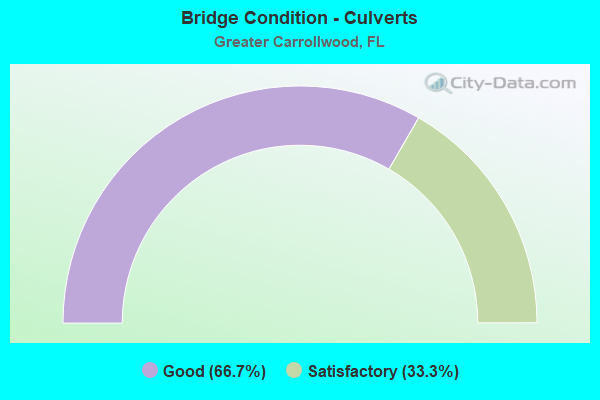
- Bridge Condition - Culverts
- 66.7%Good
- 33.3%Satisfactory
Find on map >> Show street view
Structure Number: 100085, Location: 2.8MI NORTH OF US-92 (Lat: 28.036450, Lng: -82.505011), Route carried "on" structure: State highway 597, Year Built: 1965, Year Reconstructed: 1988, Status: Open, Structure Length: 7.90m (25.92ft), Average Daily Traffic: 31,000 (year 2021), Truck Traffic: 3%, Average Future Daily Traffic: 53,785 (year 2041), Design Load: HS 20+Mod, Features Intersected: SR-580 AND CSX RR
Minimum Vertical Clearance: 30+ m (98+ ft), Kilometerpoint: 4.472, Lanes on structure: 4, Lanes under structure: 5, Base Highway Network: Yes, Owner: State Highway Agency, Approaching Roadway Width: 20.1m (65.9ft), Material/Design: Prestressed concrete, Design/Construction: Stringer/Multi-beam, Number Of Spans In Main Unit: 5, Length of Maximum Span: 16.2m (53.1ft), Curb-To-Curb Width: 19.5m (64.0ft), Out-to-Out Width: 20.4m (66.9ft)
Condition: Deck: Satisfactory, Superstructure: Good, Substructure: Good, Operating Rating: 68.0 metric tons, Method Used To Determine Operating Rating: Load Factor (LF), Inventory Rating: 60.8 metric tons, Method Used To Determine Inventory Rating: Load Factor (LF), Structural Evaluation: Better than present minimum criteria, Deck Geometry: Better than present minimum criteria, Underclear: High priority of corrective action, Approach Roadway Alignment: Equal to present desirable criteria, Designated Inspection Frequency: Every 24 months, Inspection Date: June 2021, Deck Structure Type: Concrete Cast-file-Place
Find on map >> Show street view
Structure Number: 100112, Location: 2.8MI NORTH OF US-92 (Lat: 28.036428, Lng: -82.504789), Route carried "on" structure: State highway 597, Year Built: 1956, Year Reconstructed: 1987, Status: Open, Structure Length: 7.90m (25.92ft), Average Daily Traffic: 31,000 (year 2021), Truck Traffic: 3%, Average Future Daily Traffic: 53,785 (year 2041), Design Load: HS 20+Mod, Features Intersected: SR-580 AND CSX RR
Minimum Vertical Clearance: 30+ m (98+ ft), Kilometerpoint: 4.472, Lanes on structure: 4, Lanes under structure: 5, Base Highway Network: Yes, Owner: State Highway Agency, Approaching Roadway Width: 19.5m (64.0ft), Material/Design: Prestressed concrete, Design/Construction: Stringer/Multi-beam, Number Of Spans In Main Unit: 5, Length of Maximum Span: 17.1m (56.1ft), Curb-To-Curb Width: 19.5m (64.0ft), Out-to-Out Width: 20.4m (66.9ft)
Condition: Deck: Good, Superstructure: Good, Substructure: Good, Operating Rating: 56.2 metric tons, Method Used To Determine Operating Rating: Load Factor (LF), Inventory Rating: 33.6 metric tons, Method Used To Determine Inventory Rating: Load Factor (LF), Structural Evaluation: Better than present minimum criteria, Deck Geometry: Better than present minimum criteria, Underclear: High priority of corrective action, Approach Roadway Alignment: Equal to present desirable criteria, Designated Inspection Frequency: Every 24 months, Inspection Date: June 2021, Deck Structure Type: Concrete Cast-file-Place
Find on map >> Show street view
Structure Number: 100249, Location: 0.2MI N OF LINEBAUGH AVE. (Lat: 28.042925, Lng: -82.512306), Route carried "on" structure: County highway 587, Year Built: 1970, Year Reconstructed: 1988, Status: Open, Structure Length: 1.35m (4.43ft), Average Daily Traffic: 33,600 (year 2021), Truck Traffic: 10%, Average Future Daily Traffic: 42,000 (year 2041), Design Load: HS 20, Features Intersected: SWEETWATER CREEK, Facility Carried by Structure: GUNN HIGHWAY
Minimum Vertical Clearance: 30+ m (98+ ft), Kilometerpoint: 0.000, Lanes on structure: 5, Owner: County Highway Agency, Approaching Roadway Width: 22.0m (72.2ft), Skew: 9 degrees, Material/Design: Concrete, Design/Construction: Culvert, Number Of Spans In Main Unit: 3, Length of Maximum Span: 4.8m (15.7ft)
Condition: Channel: Satisfactory, Culverts: Satisfactory, Operating Rating: 87.5 metric tons, Method Used To Determine Operating Rating: Load Factor (LF), Inventory Rating: 52.5 metric tons, Method Used To Determine Inventory Rating: Load Factor (LF), Structural Evaluation: Equal to present minimum criteria, Waterway Adequacy: Equal to present desirable criteria, Approach Roadway Alignment: Equal to present desirable criteria, Designated Inspection Frequency: Every 24 months, Inspection Date: April 2021
Find on map >> Show street view
Structure Number: 104209, Location: 0.1MI W OF DALE MABRY HWY (Lat: 28.051133, Lng: -82.505619), Route carried "on" structure: County highway , Year Built: 1965, Status: Open, Structure Length: 2.39m (7.84ft), Average Daily Traffic: 3,600 (year 2021), Truck Traffic: 1%, Average Future Daily Traffic: 4,500 (year 2041), Features Intersected: SWEETWATER CREEK, Facility Carried by Structure: HUDSON LANE
Minimum Vertical Clearance: 30+ m (98+ ft), Kilometerpoint: 0.000, Lanes on structure: 2, Owner: County Highway Agency, Approaching Roadway Width: 6.2m (20.3ft), Skew: 1 degrees, Material/Design: Prestressed concrete, Design/Construction: Channel Beam, Number Of Spans In Main Unit: 3, Length of Maximum Span: 8.0m (26.2ft), Curb or Sidewalk Widths: Left: 1.2m (3.9ft), Right: 0.0m, Curb-To-Curb Width: 7.0m (23.0ft), Out-to-Out Width: 9.2m (30.2ft)
Condition: Deck: Good, Superstructure: Good, Substructure: Satisfactory, Channel: Satisfactory, Operating Rating: 55.6 metric tons, Method Used To Determine Operating Rating: Load Factor (LF), Inventory Rating: 33.4 metric tons, Method Used To Determine Inventory Rating: Load Factor (LF), Structural Evaluation: Equal to present minimum criteria, Deck Geometry: High priority of replacement, Waterway Adequacy: Equal to present desirable criteria, Approach Roadway Alignment: Equal to present desirable criteria, Designated Inspection Frequency: Every 24 months, Inspection Date: April 2021, Deck Structure Type: Other, Wearing Surface/Protective System: Wearing Surface: Bituminous
Find on map >> Show street view
Structure Number: 104245, Location: 0.9MI S OF EHRLICH RD. (Lat: 28.074642, Lng: -82.530414), Route carried "on" structure: County highway , Year Built: 1980, Status: Open, Structure Length: 3.66m (12.01ft), Average Daily Traffic: 5,500 (year 2021), Truck Traffic: 1%, Average Future Daily Traffic: 6,875 (year 2041), Features Intersected: BRUSHY CREEK, Facility Carried by Structure: WEST VILLAGE DR.
Minimum Vertical Clearance: 30+ m (98+ ft), Kilometerpoint: 0.000, Lanes on structure: 2, Owner: County Highway Agency, Approaching Roadway Width: 10.4m (34.1ft), Material/Design: Prestressed concrete, Design/Construction: Slab, Number Of Spans In Main Unit: 4, Length of Maximum Span: 9.1m (29.9ft), Curb or Sidewalk Widths: Left: 2.1m (6.9ft), Right: 0.0m, Curb-To-Curb Width: 10.4m (34.1ft), Out-to-Out Width: 13.7m (44.9ft)
Condition: Deck: Satisfactory, Superstructure: Satisfactory, Substructure: Satisfactory, Channel: Good, Operating Rating: 49.0 metric tons, Method Used To Determine Operating Rating: Allowable Stress (AS), Inventory Rating: 34.9 metric tons, Method Used To Determine Inventory Rating: Allowable Stress (AS), Structural Evaluation: Equal to present minimum criteria, Deck Geometry: Meets minimum limits, Waterway Adequacy: Equal to present desirable criteria, Approach Roadway Alignment: Better than present minimum criteria, Designated Inspection Frequency: Every 24 months, Inspection Date: April 2021, Deck Structure Type: Concrete Precast Panels, Wearing Surface/Protective System: Wearing Surface: Integral Concrete
Find on map >> Show street view
Structure Number: 104256, Location: 0.6MI NORTH OF GUNN HWY (Lat: 28.070256, Lng: -82.541625), Route carried "on" structure: County highway , Year Built: 1985, Status: Open, Structure Length: 6.90m (22.64ft), Average Daily Traffic: 9,270 (year 2021), Truck Traffic: 5%, Average Future Daily Traffic: 11,588 (year 2041), Design Load: HS 20, Features Intersected: BRUSHY CREEK, Facility Carried by Structure: LYNN TURNER ROAD
Minimum Vertical Clearance: 30+ m (98+ ft), Kilometerpoint: 8.674, Lanes on structure: 2, Owner: County Highway Agency, Approaching Roadway Width: 8.1m (26.6ft), Material/Design: Prestressed concrete, Design/Construction: Stringer/Multi-beam, Number Of Spans In Main Unit: 4, Length of Maximum Span: 17.3m (56.8ft), Curb or Sidewalk Widths: Left: 1.2m (3.9ft), Right: 1.2m (3.9ft), Curb-To-Curb Width: 8.8m (28.9ft), Out-to-Out Width: 13.0m (42.7ft)
Condition: Deck: Good, Superstructure: Good, Substructure: Good, Channel: Good, Operating Rating: 41.5 metric tons, Method Used To Determine Operating Rating: Load Factor (LF), Inventory Rating: 33.7 metric tons, Method Used To Determine Inventory Rating: Load Factor (LF), Structural Evaluation: Better than present minimum criteria, Deck Geometry: Meets minimum limits, Waterway Adequacy: Equal to present desirable criteria, Approach Roadway Alignment: Equal to present desirable criteria, Designated Inspection Frequency: Every 24 months, Inspection Date: April 2021, Deck Structure Type: Concrete Cast-file-Place
Find on map >> Show street view
Structure Number: 104264, Location: 1.2MI W OF DALE MABRY HWY (Lat: 28.084611, Lng: -82.524750), Route carried "on" structure: County highway , Year Built: 1988, Status: Open, Structure Length: 2.60m (8.53ft), Average Daily Traffic: 35,500 (year 2021), Truck Traffic: 5%, Average Future Daily Traffic: 44,375 (year 2041), Design Load: HS 20, Features Intersected: BRUSHY CREEK, Facility Carried by Structure: EHRLICH RD
Minimum Vertical Clearance: 30+ m (98+ ft), Kilometerpoint: 4.632, Lanes on structure: 4, Owner: County Highway Agency, Approaching Roadway Width: 18.0m (59.1ft), Skew: 21 degrees, Material/Design: Concrete continuous, Design/Construction: Slab, Number Of Spans In Main Unit: 4, Length of Maximum Span: 6.5m (21.3ft), Curb or Sidewalk Widths: Left: 0.0m, Right: 1.6m (5.2ft), Curb-To-Curb Width: 20.2m (66.3ft), Out-to-Out Width: 27.4m (89.9ft)
Condition: Deck: Good, Superstructure: Good, Substructure: Good, Channel: Satisfactory, Operating Rating: 79.1 metric tons, Method Used To Determine Operating Rating: Load Factor (LF), Inventory Rating: 47.5 metric tons, Method Used To Determine Inventory Rating: Load Factor (LF), Structural Evaluation: Better than present minimum criteria, Deck Geometry: Better than present minimum criteria, Waterway Adequacy: Equal to present desirable criteria, Approach Roadway Alignment: Equal to present desirable criteria, Designated Inspection Frequency: Every 24 months, Inspection Date: April 2021, Deck Structure Type: Concrete Cast-file-Place, Wearing Surface/Protective System: Wearing Surface: Monolithic Concrete
Find on map >> Show street view
Structure Number: 104282, Location: 0.1 MI S OF GUNN HWY (Lat: 28.042900, Lng: -82.514439), Route carried "on" structure: County highway , Year Built: 1991, Status: Open, Structure Length: 2.30m (7.55ft), Average Daily Traffic: 1,500 (year 2021), Truck Traffic: 1%, Average Future Daily Traffic: 1,875 (year 2041), Design Load: HS 20+Mod, Features Intersected: SWEETWATER CREEK, Facility Carried by Structure: MULLIS CITY WAY
Minimum Vertical Clearance: 30+ m (98+ ft), Kilometerpoint: 0.000, Lanes on structure: 5, Owner: County Highway Agency, Approaching Roadway Width: 22.5m (73.8ft), Skew: 26 degrees, Material/Design: Concrete, Design/Construction: Culvert, Number Of Spans In Main Unit: 3, Length of Maximum Span: 7.8m (25.6ft)
Condition: Channel: Good, Culverts: Good, Inventory Rating: 58.2 metric tons, Method Used To Determine Inventory Rating: Load Factor (LF), Structural Evaluation: Better than present minimum criteria, Waterway Adequacy: Better than present minimum criteria, Approach Roadway Alignment: Better than present minimum criteria, Designated Inspection Frequency: Every 24 months, Inspection Date: April 2021
Find on map >> Show street view
Structure Number: 104292, Location: 0.8MI W OF GUNN HWY (Lat: 28.040167, Lng: -82.522006), Route carried "on" structure: County highway , Year Built: 2001, Status: Open, Structure Length: 3.72m (12.20ft), Average Daily Traffic: 23,448 (year 2021), Truck Traffic: 3%, Average Future Daily Traffic: 29,310 (year 2041), Design Load: HS 20+Mod, Features Intersected: SWEETWATER CREEK, Facility Carried by Structure: LINEBAUGH AVE (EB)
Minimum Vertical Clearance: 30+ m (98+ ft), Kilometerpoint: 6.181, Lanes on structure: 2, Owner: County Highway Agency, Approaching Roadway Width: 8.7m (28.5ft), Skew: 4 degrees, Material/Design: Concrete continuous, Design/Construction: Slab, Number Of Spans In Main Unit: 3, Length of Maximum Span: 12.7m (41.7ft), Curb-To-Curb Width: 11.0m (36.1ft), Out-to-Out Width: 12.1m (39.7ft)
Condition: Deck: Good, Superstructure: Good, Substructure: Good, Channel: Good, Operating Rating: 58.3 metric tons, Method Used To Determine Operating Rating: Load Factor (LF), Inventory Rating: 35.0 metric tons, Method Used To Determine Inventory Rating: Load Factor (LF), Structural Evaluation: Better than present minimum criteria, Deck Geometry: Equal to present minimum criteria, Waterway Adequacy: Superior to present desirable criteria, Approach Roadway Alignment: Equal to present desirable criteria, Designated Inspection Frequency: Every 24 months, Inspection Date: October 2021, Deck Structure Type: Concrete Cast-file-Place
Find on map >> Show street view
Structure Number: 104293, Location: 0.8 MI W OF GUNN HWY (Lat: 28.040358, Lng: -82.526194), Route carried "on" structure: County highway , Year Built: 2001, Status: Open, Structure Length: 3.69m (12.11ft), Average Daily Traffic: 23,448 (year 2021), Truck Traffic: 3%, Average Future Daily Traffic: 29,310 (year 2041), Design Load: HS 20+Mod, Features Intersected: SWEETWATER CREEK, Facility Carried by Structure: LINEBAUGH AVE (WB)
Minimum Vertical Clearance: 30.45m (99.90ft), Kilometerpoint: 6.199, Lanes on structure: 2, Owner: County Highway Agency, Approaching Roadway Width: 7.5m (24.6ft), Skew: 4 degrees, Material/Design: Concrete continuous, Design/Construction: Slab, Number Of Spans In Main Unit: 3, Length of Maximum Span: 12.7m (41.7ft), Curb or Sidewalk Widths: Left: 1.5m (4.9ft), Right: 0.0m, Curb-To-Curb Width: 9.2m (30.2ft), Out-to-Out Width: 12.0m (39.4ft)
Condition: Deck: Good, Superstructure: Good, Substructure: Very good, Channel: Good, Operating Rating: 58.3 metric tons, Method Used To Determine Operating Rating: Load Factor (LF), Inventory Rating: 35.0 metric tons, Method Used To Determine Inventory Rating: Load Factor (LF), Structural Evaluation: Better than present minimum criteria, Deck Geometry: Meets minimum limits, Waterway Adequacy: Superior to present desirable criteria, Approach Roadway Alignment: Equal to present desirable criteria, Designated Inspection Frequency: Every 24 months, Inspection Date: October 2021, Deck Structure Type: Concrete Cast-file-Place, Wearing Surface/Protective System: Wearing Surface: Epoxy Overlay
Find on map >> Show street view
Structure Number: 104295, Location: 0.2 MI W OF N DALE MABRY (Lat: 28.047450, Lng: -82.507728), Route carried "on" structure: County highway , Year Built: 1994, Status: Open, Structure Length: 0.64m (2.10ft), Average Daily Traffic: 100 (year 2021), Truck Traffic: 1%, Average Future Daily Traffic: 125 (year 2041), Design Load: HS 20+Mod, Features Intersected: SWEETWATER CREEK, Facility Carried by Structure: FLOYD ROAD
Minimum Vertical Clearance: 30+ m (98+ ft), Kilometerpoint: 0.000, Lanes on structure: 2, Owner: County Highway Agency, Approaching Roadway Width: 6.3m (20.7ft), Material/Design: Concrete, Design/Construction: Culvert, Number Of Spans In Main Unit: 2, Length of Maximum Span: 3.2m (10.5ft)
Condition: Channel: Very good, Culverts: Good, Inventory Rating: 58.2 metric tons, Method Used To Determine Inventory Rating: Load Factor (LF), Structural Evaluation: Better than present minimum criteria, Waterway Adequacy: Equal to present desirable criteria, Approach Roadway Alignment: Equal to present desirable criteria, Designated Inspection Frequency: Every 24 months, Inspection Date: April 2021
Find on map >> Show street view
Structure Number: 100085, Location: 2.8MI NORTH OF US-92 (Lat: 28.036450, Lng: -82.505011), Route carried "under" structure: State highway 580, Year Built: 1965, Structure Length: 0. m, Average Daily Traffic: 31,000 (year 2021), Truck Traffic: 3%, Features Intersected: SR-580 AND CSX RR, Facility Carried by Structure: SR-597 DALE MABRY
Minimum Vertical Clearance: 6.92m (22.70ft), Kilometerpoint: 4.472, Lanes on structure: 4, Lanes under structure: 5, Material/Design: Prestressed concrete, Design/Construction: Stringer/Multi-beam, Length of Maximum Span: 16.2m (53.1ft)
Find on map >> Show street view
Structure Number: 100112, Location: 2.8MI NORTH OF US-92 (Lat: 28.036428, Lng: -82.504789), Route carried "under" structure: State highway 580, Year Built: 1956, Structure Length: 0. m, Average Daily Traffic: 44,500 (year 2021), Truck Traffic: 5%, Features Intersected: SR-580 AND CSX RR, Facility Carried by Structure: SR-597 DALE MABRY
Minimum Vertical Clearance: 6.92m (22.70ft), Kilometerpoint: 0.000, Lanes on structure: 4, Lanes under structure: 5, Material/Design: Prestressed concrete, Design/Construction: Stringer/Multi-beam, Length of Maximum Span: 17.1m (56.1ft)