Bridge Statistics for Green Island, New York (NY)
Condition, Traffic, Stress, Structural Evaluation, Project Costs
- National Bridge Inventory (NBI) Statistics
- 21Number of bridges
- 223ft / 68.5mTotal length
- $109,205,000Total costs
- 578,920Total average daily traffic
- 31,244Total average daily truck traffic
- National Bridge Inventory (NBI) Registered Bridges for Green Island
- No street view available for this location
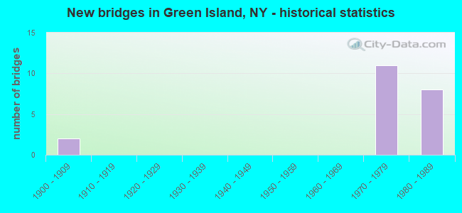
- New bridges - historical statistics
- 21900-1909
- 111970-1979
- 81980-1989


- Bridge Condition - Deck
- 10.0%Very good
- 40.0%Good
- 50.0%Satisfactory

- Bridge Condition - Superstructure
- 10.0%Very good
- 50.0%Good
- 20.0%Satisfactory
- 20.0%Fair

- Bridge Condition - Substructure
- 10.0%Very good
- 40.0%Good
- 30.0%Satisfactory
- 20.0%Fair

- Bridge Condition - Channel
- 33.3%Good
- 33.3%Satisfactory
- 33.3%Fair
Find on map >> Show street view
Structure Number: 106931, Location: .2MI S.JCT787 < ALT RTE 7 (Lat: 42.738081, Lng: -73.698389), Route carried "on" structure: ServiceOther road , Year Built: 1971, Status: Open, Structure Length: 1.07m (3.51ft), Average Daily Traffic: 1 (year 2009), Truck Traffic: 10%, Average Future Daily Traffic: 1 (year 2029), Design Load: HS 20, Features Intersected: 6TH BR.MOHAWK RIV, Facility Carried by Structure: PUMP HOUSE ACCESS
Minimum Vertical Clearance: 30+ m (98+ ft), Kilometerpoint: 0.000, Lanes on structure: 1, Owner: State Highway Agency, Approaching Roadway Width: 3.0m (9.8ft), Skew: 3 degrees, Material/Design: Concrete continuous, Design/Construction: Culvert, Number Of Spans In Main Unit: 2, Length of Maximum Span: 2.7m (8.9ft)
Condition: Channel: Fair, Culverts: Good, Structural Evaluation: Better than present minimum criteria, Waterway Adequacy: Somewhat better than minimum adequacy, Approach Roadway Alignment: High priority of corrective action, Length Of Structure Improvement: 1.06m (3.48ft), Designated Inspection Frequency: Every 24 months, Inspection Date: April 2021, Bridge Improvement Cost: $106,000, Roadway Improvement Cost: $62,000, Total Project Cost: $169,000 ( Estimate for 2021)
Find on map >> Show street view
Structure Number: 107086A, Location: VILLAGE OF GREEN ISLAND (Lat: 42.741822, Lng: -73.694264), Route carried "on" structure: Ramp Other road 787, Year Built: 1981, Status: Open, Structure Length: 5.46m (17.91ft), Average Daily Traffic: 16,839 (year 2017), Truck Traffic: 18%, Average Future Daily Traffic: 26,684 (year 2040), Design Load: HS 20, Features Intersected: FORMER D&HRR
Minimum Vertical Clearance: 30+ m (98+ ft), Kilometerpoint: 14.948, Lanes on structure: 2, Owner: State Highway Agency, Approaching Roadway Width: 11.0m (36.1ft), Skew: 2 degrees, Material/Design: Steel continuous, Design/Construction: Stringer/Multi-beam, Number Of Spans In Main Unit: 2, Length of Maximum Span: 32.9m (107.9ft), Curb-To-Curb Width: 11.1m (36.4ft), Out-to-Out Width: 12.0m (39.4ft)
Condition: Deck: Good, Superstructure: Good, Substructure: Good, Operating Rating: 87.8 metric tons, Method Used To Determine Operating Rating: Field evaluation and documented engineering judgment, Inventory Rating: 32.7 metric tons, Method Used To Determine Inventory Rating: Field evaluation and documented engineering judgment, Structural Evaluation: Better than present minimum criteria, Deck Geometry: Equal to present desirable criteria, Approach Roadway Alignment: Equal to present desirable criteria, Length Of Structure Improvement: 5.45m (17.88ft), Designated Inspection Frequency: Every 24 months, Inspection Date: July 2020, Bridge Improvement Cost: $1,447,000, Roadway Improvement Cost: $847,000, Total Project Cost: $2,294,000 ( Estimate for 2021), Deck Structure Type: Concrete Cast-file-Place, Wearing Surface/Protective System: Wearing Surface: Integral Concrete, Deck Protection: Epoxy Coated Reinforcing
Find on map >> Show street view
Structure Number: 107086B, Location: VILLAGE OF GREEN ISLAND (Lat: 42.741175, Lng: -73.694497), Route carried "on" structure: Ramp Other road 787, Year Built: 1981, Status: Open, Structure Length: 7.56m (24.80ft), Average Daily Traffic: 39,377 (year 2019), Truck Traffic: 18%, Average Future Daily Traffic: 62,400 (year 2040), Design Load: HS 20, Features Intersected: FORMER D&H RR
Minimum Vertical Clearance: 30+ m (98+ ft), Kilometerpoint: 14.948, Lanes on structure: 2, Base Highway Network: Yes, Owner: State Highway Agency, Approaching Roadway Width: 11.0m (36.1ft), Material/Design: Steel continuous, Design/Construction: Stringer/Multi-beam, Number Of Spans In Main Unit: 3, Length of Maximum Span: 35.0m (114.8ft), Curb-To-Curb Width: 10.9m (35.8ft), Out-to-Out Width: 12.0m (39.4ft)
Condition: Deck: Good, Superstructure: Good, Substructure: Good, Operating Rating: 86.9 metric tons, Method Used To Determine Operating Rating: Field evaluation and documented engineering judgment, Inventory Rating: 32.7 metric tons, Method Used To Determine Inventory Rating: Field evaluation and documented engineering judgment, Structural Evaluation: Better than present minimum criteria, Deck Geometry: Better than present minimum criteria, Approach Roadway Alignment: Equal to present desirable criteria, Length Of Structure Improvement: 7.55m (24.77ft), Designated Inspection Frequency: Every 24 months, Inspection Date: July 2020, Bridge Improvement Cost: $1,965,000, Roadway Improvement Cost: $1,151,000, Total Project Cost: $3,116,000 ( Estimate for 2021), Deck Structure Type: Concrete Cast-file-Place, Wearing Surface/Protective System: Wearing Surface: Integral Concrete, Deck Protection: Epoxy Coated Reinforcing
Find on map >> Show street view
Structure Number: 1072479, Location: .4 MI W JCT SH 7 & I787 (Lat: 42.745422, Lng: -73.704400), Route carried "on" structure: Alternate State highway 7, Year Built: 1983, Status: Open, Structure Length: 4.27m (14.01ft), Average Daily Traffic: 51,411 (year 2020), Truck Traffic: 8%, Average Future Daily Traffic: 59,575 (year 2040), Design Load: HS 20+Mod, Features Intersected: DELAWARE & HUDSON
Minimum Vertical Clearance: 30+ m (98+ ft), Kilometerpoint: 11.408, Lanes on structure: 5, Base Highway Network: Yes, Owner: State Highway Agency, Approaching Roadway Width: 38.4m (126.0ft), Skew: 31 degrees, Material/Design: Prestressed concrete, Design/Construction: Box Beam or Girders - Multiple, Number Of Spans In Main Unit: 3, Length of Maximum Span: 14.6m (47.9ft), Curb-To-Curb Width: 38.9m (127.6ft), Out-to-Out Width: 45.2m (148.3ft)
Condition: Deck: Satisfactory, Superstructure: Good, Substructure: Good, Operating Rating: 69.7 metric tons, Method Used To Determine Operating Rating: Load and Resistance Factor Rating (LRFR) rating reported by rating factor(RF) method using HL-93 loadings, Inventory Rating: 48.6 metric tons, Method Used To Determine Inventory Rating: Load and Resistance Factor Rating (LRFR) rating reported by rating factor(RF) method using HL-93 loadings, Structural Evaluation: Better than present minimum criteria, Deck Geometry: Superior to present desirable criteria, Underclear: Equal to present minimum criteria, Approach Roadway Alignment: Equal to present desirable criteria, Length Of Structure Improvement: 4.26m (13.98ft), Designated Inspection Frequency: Every 24 months, Inspection Date: September 2020, Bridge Improvement Cost: $5,737,000, Roadway Improvement Cost: $3,359,000, Total Project Cost: $9,096,000 ( Estimate for 2021), Deck Structure Type: Concrete Cast-file-Place, Wearing Surface/Protective System: Wearing Surface: Bituminous, Deck Protection: Epoxy Coated Reinforcing
Find on map >> Show street view
Structure Number: 1072489, Location: 0.2 MI W JCT RTS 7A+I787 (Lat: 42.743956, Lng: -73.701147), Route carried "on" structure: Alternate State highway 7, Year Built: 1983, Status: Open, Structure Length: 3.57m (11.71ft), Average Daily Traffic: 51,411 (year 2020), Truck Traffic: 8%, Average Future Daily Traffic: 59,575 (year 2040), Design Load: HS 20+Mod, Features Intersected: RTE 32
Minimum Vertical Clearance: 30+ m (98+ ft), Kilometerpoint: 11.730, Lanes on structure: 7, Lanes under structure: 2, Base Highway Network: Yes, Owner: State Highway Agency, Approaching Roadway Width: 45.4m (149.0ft), Skew: 33 degrees, Material/Design: Steel, Design/Construction: Stringer/Multi-beam, Number Of Spans In Main Unit: 1, Length of Maximum Span: 34.7m (113.8ft), Curb-To-Curb Width: 45.4m (149.0ft), Out-to-Out Width: 49.0m (160.8ft)
Condition: Deck: Very good, Superstructure: Good, Substructure: Very good, Inventory Rating: 64.4 metric tons, Method Used To Determine Inventory Rating: Load Factor (LF), Structural Evaluation: Better than present minimum criteria, Deck Geometry: Superior to present desirable criteria, Underclear: Equal to present minimum criteria, Approach Roadway Alignment: Equal to present desirable criteria, Length Of Structure Improvement: 3.56m (11.68ft), Designated Inspection Frequency: Every 24 months, Inspection Date: April 2020, Bridge Improvement Cost: $4,910,000, Roadway Improvement Cost: $2,875,000, Total Project Cost: $7,786,000 ( Estimate for 2021), Deck Structure Type: Concrete Cast-file-Place, Wearing Surface/Protective System: Wearing Surface: Epoxy Overlay, Deck Protection: Epoxy Coated Reinforcing
Find on map >> Show street view
Structure Number: 109225, Location: SH 7 WB OFF TO I787 SB (Lat: 42.744164, Lng: -73.697433), Route carried "on" structure: Ramp Interstate 787, Year Built: 1971, Status: Open, Structure Length: 4.33m (14.21ft), Average Daily Traffic: 40,877 (year 1989), Truck Traffic: 9%, Average Future Daily Traffic: 57,228 (year 2009), Design Load: HS 20, Features Intersected: 787I 787I 1101 4006 NB,
Minimum Vertical Clearance: 30+ m (98+ ft), Kilometerpoint: 15.012, Lanes on structure: 2, Lanes under structure: 4, Base Highway Network: Yes, Owner: State Highway Agency, Approaching Roadway Width: 13.1m (43.0ft), Skew: 1 degrees, Material/Design: Steel, Design/Construction: Stringer/Multi-beam, Number Of Spans In Main Unit: 1, Length of Maximum Span: 41.7m (136.8ft), Curb-To-Curb Width: 12.5m (41.0ft), Out-to-Out Width: 13.4m (44.0ft)
Condition: Deck: Satisfactory, Superstructure: Satisfactory, Substructure: Satisfactory, Inventory Rating: 32.7 metric tons, Method Used To Determine Inventory Rating: Field evaluation and documented engineering judgment, Structural Evaluation: Equal to present minimum criteria, Deck Geometry: Superior to present desirable criteria, Underclear: Meets minimum limits, Approach Roadway Alignment: Equal to present desirable criteria, Length Of Structure Improvement: 4.32m (14.17ft), Designated Inspection Frequency: Every 24 months, Inspection Date: November 2021, Bridge Improvement Cost: $1,773,000, Roadway Improvement Cost: $1,038,000, Total Project Cost: $2,812,000 ( Estimate for 2021), Deck Structure Type: Concrete Cast-file-Place, Wearing Surface/Protective System: Wearing Surface: Monolithic Concrete
Find on map >> Show street view
Structure Number: 1092269, Location: JCT ALT RT 7 & I787 (Lat: 42.742367, Lng: -73.697581), Route carried "on" structure: State highway 7, Year Built: 1971, Status: Open, Structure Length: 5.18m (16.99ft), Average Daily Traffic: 51,411 (year 2020), Truck Traffic: 8%, Average Future Daily Traffic: 59,575 (year 2040), Design Load: HS 20, Features Intersected: 787I 787I 1101 4004 NB,
Minimum Vertical Clearance: 30+ m (98+ ft), Kilometerpoint: 12.035, Lanes on structure: 7, Lanes under structure: 6, Base Highway Network: Yes, Owner: State Highway Agency, Approaching Roadway Width: 48.5m (159.1ft), Skew: 21 degrees, Material/Design: Steel, Design/Construction: Stringer/Multi-beam, Number Of Spans In Main Unit: 1, Length of Maximum Span: 50.9m (167.0ft), Curb-To-Curb Width: 45.6m (149.6ft), Out-to-Out Width: 48.3m (158.5ft)
Condition: Deck: Satisfactory, Superstructure: Fair, Substructure: Satisfactory, Inventory Rating: 71.7 metric tons, Method Used To Determine Inventory Rating: Load Factor (LF), Structural Evaluation: Somewhat better than minimum adequacy, Deck Geometry: Superior to present desirable criteria, Underclear: Meets minimum limits, Approach Roadway Alignment: Equal to present desirable criteria, Length Of Structure Improvement: 5.18m (16.99ft), Designated Inspection Frequency: Every 24 months, Inspection Date: November 2021, Bridge Improvement Cost: $7,397,000, Roadway Improvement Cost: $4,332,000, Total Project Cost: $11,728,000 ( Estimate for 2021), Deck Structure Type: Concrete Cast-file-Place, Wearing Surface/Protective System: Wearing Surface: Monolithic Concrete
Find on map >> Show street view
Structure Number: 1092281, Location: ALT RT 7 & I787 ON RAMPSB (Lat: 42.743419, Lng: -73.699567), Route carried "on" structure: State highway 7, Year Built: 1970, Status: Open, Structure Length: 2.90m (9.51ft), Average Daily Traffic: 25,706 (year 2020), Truck Traffic: 8%, Average Future Daily Traffic: 29,787 (year 2040), Design Load: HS 20, Features Intersected: RTE I787
Minimum Vertical Clearance: 30+ m (98+ ft), Kilometerpoint: 11.874, Lanes on structure: 2, Lanes under structure: 1, Base Highway Network: Yes, Owner: State Highway Agency, Approaching Roadway Width: 17.1m (56.1ft), Skew: 1 degrees, Material/Design: Steel, Design/Construction: Stringer/Multi-beam, Number Of Spans In Main Unit: 1, Length of Maximum Span: 27.7m (90.9ft), Curb-To-Curb Width: 12.5m (41.0ft), Out-to-Out Width: 13.4m (44.0ft)
Condition: Deck: Satisfactory, Superstructure: Fair, Substructure: Good, Operating Rating: 77.8 metric tons, Method Used To Determine Operating Rating: Load and Resistance Factor Rating (LRFR) rating reported by rating factor(RF) method using HL-93 loadings, Inventory Rating: 59.9 metric tons, Method Used To Determine Inventory Rating: Load and Resistance Factor Rating (LRFR) rating reported by rating factor(RF) method using HL-93 loadings, Structural Evaluation: Somewhat better than minimum adequacy, Deck Geometry: Better than present minimum criteria, Underclear: Somewhat better than minimum adequacy, Approach Roadway Alignment: Equal to present desirable criteria, Length Of Structure Improvement: 2.89m (9.48ft), Designated Inspection Frequency: Every 24 months, Inspection Date: May 2020, Bridge Improvement Cost: $1,296,000, Roadway Improvement Cost: $759,000, Total Project Cost: $2,054,000 ( Estimate for 2021), Deck Structure Type: Concrete Cast-file-Place, Wearing Surface/Protective System: Wearing Surface: Monolithic Concrete
Find on map >> Show street view
Structure Number: 1092282, Location: ALT RT 7 & I787 ON RAMPSB (Lat: 42.743297, Lng: -73.699728), Route carried "on" structure: State highway 7, Year Built: 1970, Status: Open, Structure Length: 2.90m (9.51ft), Average Daily Traffic: 25,706 (year 2020), Truck Traffic: 8%, Average Future Daily Traffic: 29,787 (year 2040), Design Load: HS 20, Features Intersected: RTE I787
Minimum Vertical Clearance: 30+ m (98+ ft), Kilometerpoint: 11.874, Lanes on structure: 3, Lanes under structure: 1, Base Highway Network: Yes, Owner: State Highway Agency, Approaching Roadway Width: 17.1m (56.1ft), Skew: 31 degrees, Material/Design: Steel, Design/Construction: Stringer/Multi-beam, Number Of Spans In Main Unit: 1, Length of Maximum Span: 27.7m (90.9ft), Curb-To-Curb Width: 21.0m (68.9ft), Out-to-Out Width: 22.7m (74.5ft)
Condition: Deck: Good, Superstructure: Satisfactory, Substructure: Fair, Operating Rating: 82.6 metric tons, Method Used To Determine Operating Rating: Load and Resistance Factor Rating (LRFR) rating reported by rating factor(RF) method using HL-93 loadings, Inventory Rating: 63.8 metric tons, Method Used To Determine Inventory Rating: Load and Resistance Factor Rating (LRFR) rating reported by rating factor(RF) method using HL-93 loadings, Structural Evaluation: Somewhat better than minimum adequacy, Deck Geometry: Superior to present desirable criteria, Underclear: Somewhat better than minimum adequacy, Approach Roadway Alignment: Equal to present desirable criteria, Length Of Structure Improvement: 2.89m (9.48ft), Designated Inspection Frequency: Every 24 months, Inspection Date: May 2020, Bridge Improvement Cost: $2,194,000, Roadway Improvement Cost: $1,285,000, Total Project Cost: $3,479,000 ( Estimate for 2021), Deck Structure Type: Concrete Cast-file-Place, Wearing Surface/Protective System: Wearing Surface: Monolithic Concrete
Find on map >> Show street view
Structure Number: 109589, Location: IN VIL. OF GREEN ISLAND (Lat: 42.736603, Lng: -73.692569), Route carried "on" structure: Spur City street 915, Year Built: 1982, Status: Open, Structure Length: 11.67m (38.29ft), Average Daily Traffic: 12,689 (year 2020), Truck Traffic: 3%, Average Future Daily Traffic: 15,414 (year 2040), Design Load: HS 20, Features Intersected: W CHANNEL HUDSON R
Minimum Vertical Clearance: 30+ m (98+ ft), Kilometerpoint: 0.048, Lanes on structure: 4, Base Highway Network: Yes, Owner: State Highway Agency, Approaching Roadway Width: 15.5m (50.9ft), Skew: 1 degrees, Material/Design: Steel continuous, Design/Construction: Stringer/Multi-beam, Number Of Spans In Main Unit: 2, Length of Maximum Span: 57.6m (189.0ft), Curb or Sidewalk Widths: Left: 1.5m (4.9ft), Right: 1.7m (5.6ft), Curb-To-Curb Width: 15.5m (50.9ft), Out-to-Out Width: 19.7m (64.6ft)
Condition: Deck: Satisfactory, Superstructure: Very good, Substructure: Fair, Channel: Good, Inventory Rating: 67.1 metric tons, Method Used To Determine Inventory Rating: Load Factor (LF), Structural Evaluation: Somewhat better than minimum adequacy, Deck Geometry: Meets minimum limits, Waterway Adequacy: Equal to present minimum criteria, Approach Roadway Alignment: Equal to present desirable criteria, Length Of Structure Improvement: 11.67m (38.29ft), Designated Inspection Frequency: Every 24 months, Inspection Date: June 2020, Bridge Improvement Cost: $5,364,000, Roadway Improvement Cost: $3,141,000, Total Project Cost: $8,506,000 ( Estimate for 2021), Deck Structure Type: Concrete Cast-file-Place, Wearing Surface/Protective System: Wearing Surface: Integral Concrete, Deck Protection: Epoxy Coated Reinforcing
Find on map >> Show street view
Structure Number: 109591, Location: IN VIL. OF GREEN ISLAND (Lat: 42.735103, Lng: -73.688908), Route carried "on" structure: Spur City street 915, Year Built: 1982, Status: Open, Structure Length: 19.57m (64.21ft), Average Daily Traffic: 10,344 (year 2008), Truck Traffic: 6%, Average Future Daily Traffic: 12,565 (year 2040), Design Load: HS 20, Features Intersected: PARKING LT ACCESS, E CHA
Minimum Vertical Clearance: 10.36m (33.99ft), Kilometerpoint: 0.000, Lanes on structure: 4, Lanes under structure: 2, Base Highway Network: Yes, Owner: State Highway Agency, Approaching Roadway Width: 17.1m (56.1ft), Navigation Control: Yes ( Vertical Clearance: 18.2m (59.7ft), Horizontal Clearance: 56.0m (183.7ft)), Material/Design: Steel, Design/Construction: Movable - Lift, Number Of Spans In Main Unit: 5, Length of Maximum Span: 60.9m (199.8ft), Curb or Sidewalk Widths: Left: 0.0m, Right: 1.8m (5.9ft), Curb-To-Curb Width: 17.1m (56.1ft), Out-to-Out Width: 19.7m (64.6ft)
Condition: Deck: Good, Superstructure: Good, Substructure: Satisfactory, Channel: Satisfactory, Operating Rating: 41.8 metric tons, Method Used To Determine Operating Rating: Load and Resistance Factor Rating (LRFR) rating reported by rating factor(RF) method using HL-93 loadings, Inventory Rating: 32.4 metric tons, Method Used To Determine Inventory Rating: Load and Resistance Factor Rating (LRFR) rating reported by rating factor(RF) method using HL-93 loadings, Structural Evaluation: Equal to present minimum criteria, Deck Geometry: Somewhat better than minimum adequacy, Underclear: High priority of corrective action, Waterway Adequacy: Equal to present desirable criteria, Approach Roadway Alignment: Equal to present desirable criteria, Length Of Structure Improvement: 19.56m (64.17ft), Designated Inspection Frequency: Every 24 months, Critical Feature Inspection Frequency: Every 24 months, Underwater Inspection Frequency: Every 60 months, Inspection Date: July 2020, Critical Feature Inspection Date: July 2020, Underwater Inspection Date: August 2017, Bridge Improvement Cost: $36,683,000, Roadway Improvement Cost: $21,482,000, Total Project Cost: $58,165,000 ( Estimate for 2021), Deck Structure Type: Concrete Cast-file-Place, Wearing Surface/Protective System: Wearing Surface: Integral Concrete, Deck Protection: Epoxy Coated Reinforcing
Find on map >> Show street view
Structure Number: 1070869, Location: RTE.787I AND HUDSON RIVER (Lat: 42.740858, Lng: -73.691156), Route carried "under" structure: City street , Year Built: 1981, Structure Length: 0. m, Average Daily Traffic: 100 (year 2021), Features Intersected: HUDSON AVENUE, HUDSON RI, Facility Carried by Structure: RTE I787
Minimum Vertical Clearance: 10.06m (33.01ft), Kilometerpoint: 0.000, Lanes on structure: 8, Lanes under structure: 2, Material/Design: Steel continuous, Design/Construction: Stringer/Multi-beam, Length of Maximum Span: 115.8m (379.9ft)
Find on map >> Show street view
Structure Number: 1072489, Location: 0.2 MI W JCT RTS 7A+I787 (Lat: 42.743956, Lng: -73.701147), Route carried "under" structure: State highway 32, Year Built: 1983, Structure Length: 0. m, Average Daily Traffic: 6,283 (year 1999), Features Intersected: RTE 32, Facility Carried by Structure: RTE 7
Minimum Vertical Clearance: 4.88m (16.01ft), Kilometerpoint: 0.724, Lanes on structure: 7, Lanes under structure: 2, Material/Design: Steel, Design/Construction: Stringer/Multi-beam, Length of Maximum Span: 34.7m (113.8ft)
Find on map >> Show street view
Structure Number: 109225, Location: SH 7 WB OFF TO I787 SB (Lat: 42.744164, Lng: -73.697433), Route carried "under" structure: Interstate 787, Year Built: 1971, Structure Length: 0. m, Average Daily Traffic: 71,733 (year 2002), Features Intersected: 787I 787I 1101 4006 NB,
Minimum Vertical Clearance: 5.56m (18.24ft), Kilometerpoint: 15.012, Lanes on structure: 2, Lanes under structure: 2, Material/Design: Steel, Design/Construction: Stringer/Multi-beam, Length of Maximum Span: 41.7m (136.8ft)
Find on map >> Show street view
Structure Number: 1092269, Location: JCT ALT RT 7 & I787 (Lat: 42.742367, Lng: -73.697581), Route carried "under" structure: Interstate 787, Year Built: 1971, Structure Length: 0. m, Average Daily Traffic: 71,733 (year 2002), Features Intersected: 787I 787I 1101 4004 NB,, Facility Carried by Structure: RTE 7
Minimum Vertical Clearance: 5.13m (16.83ft), Kilometerpoint: 14.883, Lanes on structure: 7, Lanes under structure: 3, Material/Design: Steel, Design/Construction: Stringer/Multi-beam, Length of Maximum Span: 50.9m (167.0ft)
Find on map >> Show street view
Structure Number: 1092281, Location: ALT RT 7 & I787 ON RAMPSB (Lat: 42.743419, Lng: -73.699567), Route carried "under" structure: Interstate 787, Year Built: 1970, Structure Length: 0. m, Average Daily Traffic: 9,500 (year 1981), Features Intersected: RTE I787, Facility Carried by Structure: RTE 7
Minimum Vertical Clearance: 5.00m (16.40ft), Kilometerpoint: 14.803, Lanes on structure: 2, Lanes under structure: 1, Material/Design: Steel, Design/Construction: Stringer/Multi-beam, Length of Maximum Span: 27.7m (90.9ft)
Find on map >> Show street view
Structure Number: 1092282, Location: ALT RT 7 & I787 ON RAMPSB (Lat: 42.743297, Lng: -73.699728), Route carried "under" structure: Interstate 787, Year Built: 1970, Structure Length: 0. m, Average Daily Traffic: 9,500 (year 1981), Features Intersected: RTE I787, Facility Carried by Structure: RTE 7
Minimum Vertical Clearance: 6.05m (19.85ft), Kilometerpoint: 14.803, Lanes on structure: 3, Lanes under structure: 1, Material/Design: Steel, Design/Construction: Stringer/Multi-beam, Length of Maximum Span: 27.7m (90.9ft)
Find on map >> Show street view
Structure Number: 7022491, Location: .1 MI W INT 787I & D&H RR (Lat: 42.739172, Lng: -73.700486), Route carried "under" structure: State highway 32, Year Built: 1900, Structure Length: 0. m, Average Daily Traffic: 6,283 (year 1999), Features Intersected: RTE 32, Facility Carried by Structure: DELAWARE & HUDSON
Minimum Vertical Clearance: 4.31m (14.14ft), Kilometerpoint: 0.290, Lanes under structure: 2, Material/Design: Steel, Design/Construction: Girder and Floorbeam System, Length of Maximum Span: 22.8m (74.8ft)
Find on map >> Show street view
Structure Number: 7022492, Location: .1 MI W INT 787I & D&H RR (Lat: 42.739253, Lng: -73.700489), Route carried "under" structure: State highway 32, Year Built: 1900, Structure Length: 0. m, Average Daily Traffic: 6,283 (year 1999), Features Intersected: RTE 32, Facility Carried by Structure: DELAWARE & HUDSON
Minimum Vertical Clearance: 5.00m (16.40ft), Kilometerpoint: 0.290, Lanes under structure: 2, Material/Design: Steel, Design/Construction: Girder and Floorbeam System, Length of Maximum Span: 22.8m (74.8ft)
Find on map >> Show street view
Structure Number: 70923, Location: I787 & D&H RAILROAD (Lat: 42.738914, Lng: -73.698894), Route carried "under" structure: Interstate 787, Year Built: 1971, Structure Length: 0. m, Average Daily Traffic: 71,733 (year 2002), Features Intersected: 787I 787I 1101 4002, RTE, Facility Carried by Structure: FORMER D&HRR
Minimum Vertical Clearance: 5.13m (16.83ft), Kilometerpoint: 14.417, Lanes under structure: 4, Material/Design: Steel, Design/Construction: Girder and Floorbeam System, Length of Maximum Span: 23.7m (77.8ft)
Find on map >> Show street view
Structure Number: 70923, Location: I787 & D&H RAILROAD (Lat: 42.738914, Lng: -73.698894), Route carried "under" structure: Interstate , Year Built: 1971, Structure Length: 0. m, Features Intersected: 787I 787I 1101 4002, RTE, Facility Carried by Structure: FORMER D&HRR
Minimum Vertical Clearance: 4.90m (16.08ft), Kilometerpoint: 14.417, Lanes under structure: 4, Material/Design: Steel, Design/Construction: Girder and Floorbeam System, Length of Maximum Span: 23.7m (77.8ft)