Bridge Statistics for Green Ridge, Missouri (MO)
Condition, Traffic, Stress, Structural Evaluation, Project Costs
- National Bridge Inventory (NBI) Statistics
- 12Number of bridges
- 59ft / 17.8mTotal length
- $1,438,000Total costs
- 6,738Total average daily traffic
- 967Total average daily truck traffic
- 10,818Total future (year 2040) average daily traffic
- National Bridge Inventory (NBI) Registered Bridges for Green Ridge
- No street view available for this location
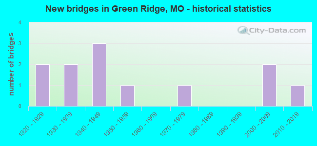
- New bridges - historical statistics
- 21920-1929
- 21930-1939
- 31940-1949
- 11950-1959
- 11970-1979
- 22000-2009
- 12010-2019

- Bridge Condition - Deck
- 20.0%Very good
- 60.0%Good
- 20.0%Serious

- Bridge Condition - Superstructure
- 20.0%Good
- 40.0%Satisfactory
- 40.0%Serious

- Bridge Condition - Substructure
- 20.0%Excellent
- 20.0%Good
- 20.0%Satisfactory
- 20.0%Fair
- 20.0%Poor

- Bridge Condition - Channel
- 16.7%Good
- 41.7%Satisfactory
- 33.3%Fair
- 8.3%Poor

- Bridge Condition - Culverts
- 28.6%Very good
- 42.9%Satisfactory
- 14.3%Fair
- 14.3%Poor
Find on map >> Show street view
Structure Number: 21975, Location: S 5 T 44 N R 22 W (Lat: 38.610339, Lng: -93.374889), Route carried "on" structure: County highway 333, Year Built: 1977, Status: Open, Structure Length: 3.96m (12.99ft), Average Daily Traffic: 35 (year 2020), Truck Traffic: 10%, Average Future Daily Traffic: 60 (year 2040), Features Intersected: SMALL CR, Facility Carried by Structure: DOVE RD
Minimum Vertical Clearance: 30+ m (98+ ft), Kilometerpoint: 0.483, Lanes on structure: 2, Owner: County Highway Agency, Approaching Roadway Width: 6.7m (22.0ft), Material/Design: Prestressed concrete, Design/Construction: Tee Beam, Number Of Spans In Main Unit: 3, Length of Maximum Span: 13.1m (43.0ft), Curb-To-Curb Width: 7.4m (24.3ft), Out-to-Out Width: 8.2m (26.9ft)
Condition: Deck: Good, Superstructure: Satisfactory, Substructure: Satisfactory, Channel: Fair, Operating Rating: 49.5 metric tons, Method Used To Determine Operating Rating: Allowable Stress (AS), Inventory Rating: 16.2 metric tons, Method Used To Determine Inventory Rating: Allowable Stress (AS), Structural Evaluation: Somewhat better than minimum adequacy, Deck Geometry: Equal to present minimum criteria, Waterway Adequacy: Equal to present desirable criteria, Approach Roadway Alignment: Equal to present desirable criteria, Designated Inspection Frequency: Every 24 months, Inspection Date: Febuary 2022, Deck Structure Type: Concrete Cast-file-Place, Wearing Surface/Protective System: Wearing Surface: Monolithic Concrete
Find on map >> Show street view
Structure Number: 22016, Location: S 12 T 44 N R 23 W (Lat: 38.597039, Lng: -93.413528), Route carried "on" structure: County highway 336, Year Built: 1935, Status: Open, Structure Length: 0.70m (2.30ft), Average Daily Traffic: 40 (year 2020), Truck Traffic: 10%, Average Future Daily Traffic: 68 (year 2040), Features Intersected: SMALL CR, Facility Carried by Structure: WHITE RD
Minimum Vertical Clearance: 30+ m (98+ ft), Kilometerpoint: 0.322, Lanes on structure: 2, Owner: County Highway Agency, Approaching Roadway Width: 6.1m (20.0ft), Material/Design: Concrete, Design/Construction: Culvert, Number Of Spans In Main Unit: 2, Length of Maximum Span: 3.4m (11.2ft), Curb-To-Curb Width: 5.8m (19.0ft), Out-to-Out Width: 6.3m (20.7ft)
Condition: Channel: Satisfactory, Culverts: Poor, Operating Rating: 49.5 metric tons, Method Used To Determine Operating Rating: Allowable Stress (AS), Inventory Rating: 22.5 metric tons, Method Used To Determine Inventory Rating: Allowable Stress (AS), Structural Evaluation: Meets minimum limits, Deck Geometry: Meets minimum limits, Waterway Adequacy: Better than present minimum criteria, Approach Roadway Alignment: Equal to present desirable criteria, Length Of Structure Improvement: 0.13m (0.43ft), Designated Inspection Frequency: Every 24 months, Inspection Date: Febuary 2022, Bridge Improvement Cost: $85,000, Roadway Improvement Cost: $9,000, Total Project Cost: $128,000 ( Estimate for 2022)
Find on map >> Show street view
Structure Number: 22039, Location: S 17 T 44 N R 22 W (Lat: 38.583850, Lng: -93.361950), Route carried "on" structure: County highway 337, Year Built: 1925, Status: Open, Structure Length: 0.76m (2.49ft), Average Daily Traffic: 35 (year 2020), Truck Traffic: 10%, Average Future Daily Traffic: 60 (year 2040), Features Intersected: SMALL CR, Facility Carried by Structure: BRYSON RD
Minimum Vertical Clearance: 30+ m (98+ ft), Kilometerpoint: 1.127, Lanes on structure: 1, Owner: County Highway Agency, Approaching Roadway Width: 5.2m (17.1ft), Material/Design: Concrete, Design/Construction: Culvert, Number Of Spans In Main Unit: 2, Length of Maximum Span: 3.7m (12.1ft), Curb-To-Curb Width: 5.1m (16.7ft), Out-to-Out Width: 5.5m (18.0ft)
Condition: Channel: Fair, Culverts: Satisfactory, Operating Rating: 49.5 metric tons, Method Used To Determine Operating Rating: Allowable Stress (AS), Inventory Rating: 16.2 metric tons, Method Used To Determine Inventory Rating: Allowable Stress (AS), Structural Evaluation: Somewhat better than minimum adequacy, Deck Geometry: High priority of corrective action, Waterway Adequacy: Better than present minimum criteria, Approach Roadway Alignment: Equal to present minimum criteria, Length Of Structure Improvement: 0.14m (0.46ft), Designated Inspection Frequency: Every 24 months, Inspection Date: Febuary 2022, Bridge Improvement Cost: $85,000, Roadway Improvement Cost: $9,000, Total Project Cost: $128,000 ( Estimate for 2022)
Find on map >> Show street view
Structure Number: 22443, Location: S 4 T 44 N R 22 W (Lat: 38.626839, Lng: -93.350628), Route carried "on" structure: County highway 356, Year Built: 1955, Status: Closed, Structure Length: 1.80m (5.91ft), Average Daily Traffic: 25 (year 2020), Truck Traffic: 10%, Average Future Daily Traffic: 43 (year 2040), Features Intersected: BASIN FK, Facility Carried by Structure: HARDING RD
Minimum Vertical Clearance: 30+ m (98+ ft), Kilometerpoint: 1.127, Lanes on structure: 1, Owner: County Highway Agency, Approaching Roadway Width: 6.1m (20.0ft), Material/Design: Steel, Design/Construction: Girder and Floorbeam System, Number Of Spans In Main Unit: 2, Length of Maximum Span: 8.5m (27.9ft), Curb-To-Curb Width: 4.6m (15.1ft), Out-to-Out Width: 4.8m (15.7ft)
Condition: Deck: Good, Superstructure: Serious, Substructure: Poor, Channel: Poor, Deck Geometry: Better than present minimum criteria, Waterway Adequacy: Equal to present minimum criteria, Approach Roadway Alignment: Equal to present minimum criteria, Bridge Posting: Required (Relationship of Operating Rating to Maximum Legal Load: > 39.9% below), Length Of Structure Improvement: 0.25m (0.82ft), Designated Inspection Frequency: Every 24 months, Critical Feature Inspection Frequency: Every 24 months, Underwater Inspection Frequency: Every 60 months, Inspection Date: Febuary 2022, Critical Feature Inspection Date: Febuary 2020, Underwater Inspection Date: August 2020, Bridge Improvement Cost: $182,000, Roadway Improvement Cost: $18,000, Total Project Cost: $273,000 ( Estimate for 2022), Deck Structure Type: Corrugated Steel, Wearing Surface/Protective System: Wearing Surface: Wood or Timber
Find on map >> Show street view
Structure Number: 24046, Location: S 13 T 44 N R 23 W (Lat: 38.594319, Lng: -93.416539), Route carried "on" structure: County highway 453, Year Built: 1925, Year Reconstructed: 1987, Status: Posted for load, Structure Length: 0.91m (2.99ft), Average Daily Traffic: 10 (year 2020), Truck Traffic: 10%, Average Future Daily Traffic: 17 (year 2040), Features Intersected: TRIB OF BASIN FK, Facility Carried by Structure: REED RD
Minimum Vertical Clearance: 30+ m (98+ ft), Kilometerpoint: 0.161, Lanes on structure: 1, Owner: County Highway Agency, Approaching Roadway Width: 5.2m (17.1ft), Material/Design: Steel, Design/Construction: Stringer/Multi-beam, Number Of Spans In Main Unit: 1, Length of Maximum Span: 8.5m (27.9ft), Curb-To-Curb Width: 5.2m (17.1ft), Out-to-Out Width: 5.5m (18.0ft)
Condition: Deck: Very good, Superstructure: Satisfactory, Substructure: Good, Channel: Satisfactory, Operating Rating: 7.2 metric tons, Method Used To Determine Operating Rating: Allowable Stress (AS), Inventory Rating: 4.5 metric tons, Method Used To Determine Inventory Rating: Allowable Stress (AS), Structural Evaluation: High priority of replacement, Deck Geometry: High priority of corrective action, Waterway Adequacy: Equal to present minimum criteria, Approach Roadway Alignment: Equal to present minimum criteria, Bridge Posting: Required (Relationship of Operating Rating to Maximum Legal Load: > 39.9% below), Length Of Structure Improvement: 0.16m (0.52ft), Designated Inspection Frequency: Every 24 months, Inspection Date: Febuary 2022, Bridge Improvement Cost: $115,000, Roadway Improvement Cost: $12,000, Total Project Cost: $173,000 ( Estimate for 2022), Deck Structure Type: Wood or Timber, Wearing Surface/Protective System: Wearing Surface: Wood or Timber
Find on map >> Show street view
Structure Number: 28941, Location: S 25 T 45 N R 22 W (Lat: 38.655167, Lng: -93.360028), Route carried "on" structure: County highway 375, Year Built: 2002, Status: Open, Structure Length: 0.79m (2.59ft), Average Daily Traffic: 40 (year 2020), Truck Traffic: 10%, Average Future Daily Traffic: 68 (year 2040), Features Intersected: BR OF CAMP CR, Facility Carried by Structure: CAMP BRANCH RD
Minimum Vertical Clearance: 30+ m (98+ ft), Kilometerpoint: 6.116, Lanes on structure: 2, Owner: County Highway Agency, Approaching Roadway Width: 7.3m (24.0ft), Material/Design: Aluminum, Iron, Design/Construction: Culvert, Number Of Spans In Main Unit: 1, Length of Maximum Span: 7.9m (25.9ft)
Condition: Channel: Satisfactory, Culverts: Very good, Operating Rating: 54.0 metric tons, Method Used To Determine Operating Rating: Load Factor (LF), Inventory Rating: 32.4 metric tons, Method Used To Determine Inventory Rating: Load Factor (LF), Structural Evaluation: Equal to present desirable criteria, Waterway Adequacy: Better than present minimum criteria, Approach Roadway Alignment: Equal to present desirable criteria, Designated Inspection Frequency: Every 24 months, Inspection Date: Febuary 2022
Find on map >> Show street view
Structure Number: 28958, Location: S 28 T 45 N R 23 W (Lat: 38.655347, Lng: -93.460556), Route carried "on" structure: County highway 383, Year Built: 2002, Status: Open, Structure Length: 2.34m (7.68ft), Average Daily Traffic: 150 (year 2020), Truck Traffic: 10%, Average Future Daily Traffic: 255 (year 2040), Design Load: HS 20, Features Intersected: ELK FK MUDDY RVR, Facility Carried by Structure: HICKORY POINT RD
Minimum Vertical Clearance: 30+ m (98+ ft), Kilometerpoint: 0.000, Lanes on structure: 2, Owner: County Highway Agency, Approaching Roadway Width: 7.3m (24.0ft), Material/Design: Prestressed concrete, Design/Construction: Stringer/Multi-beam, Number Of Spans In Main Unit: 1, Length of Maximum Span: 22.9m (75.1ft), Curb-To-Curb Width: 7.3m (24.0ft), Out-to-Out Width: 8.0m (26.2ft)
Condition: Deck: Good, Superstructure: Good, Substructure: Excellent, Channel: Good, Operating Rating: 54.0 metric tons, Method Used To Determine Operating Rating: Load Factor (LF), Inventory Rating: 32.4 metric tons, Method Used To Determine Inventory Rating: Load Factor (LF), Structural Evaluation: Better than present minimum criteria, Deck Geometry: Somewhat better than minimum adequacy, Waterway Adequacy: Equal to present minimum criteria, Approach Roadway Alignment: Equal to present desirable criteria, Designated Inspection Frequency: Every 24 months, Inspection Date: Febuary 2022, Deck Structure Type: Concrete Cast-file-Place, Wearing Surface/Protective System: Wearing Surface: Integral Concrete
Find on map >> Show street view
Structure Number: 32992, Location: S 34 T 45 N R 23 W (Lat: 38.633589, Lng: -93.452514), Route carried "on" structure: County highway 328, Year Built: 2010, Status: Open, Structure Length: 0.79m (2.59ft), Average Daily Traffic: 20 (year 2020), Truck Traffic: 10%, Average Future Daily Traffic: 34 (year 2040), Features Intersected: ELK CR, Facility Carried by Structure: EASTER RD
Minimum Vertical Clearance: 30+ m (98+ ft), Kilometerpoint: 0.000, Lanes on structure: 2, Owner: County Highway Agency, Approaching Roadway Width: 6.1m (20.0ft), Material/Design: Aluminum, Iron, Design/Construction: Culvert, Number Of Spans In Main Unit: 1, Length of Maximum Span: 7.9m (25.9ft), Curb-To-Curb Width: 7.3m (24.0ft), Out-to-Out Width: 7.3m (24.0ft)
Condition: Channel: Satisfactory, Culverts: Very good, Operating Rating: 54.0 metric tons, Method Used To Determine Operating Rating: Load Factor (LF), Inventory Rating: 32.4 metric tons, Method Used To Determine Inventory Rating: Load Factor (LF), Structural Evaluation: Equal to present desirable criteria, Deck Geometry: Equal to present minimum criteria, Waterway Adequacy: Better than present minimum criteria, Approach Roadway Alignment: Equal to present desirable criteria, Designated Inspection Frequency: Every 24 months, Inspection Date: Febuary 2022
Find on map >> Show street view
Structure Number: 6232, Location: S 12 T 44 N R 23 W (Lat: 38.609922, Lng: -93.415961), Route carried "on" structure: State highway 127, Year Built: 1949, Status: Open, Structure Length: 0.65m (2.13ft), Average Daily Traffic: 1,625 (year 2021), Truck Traffic: 17%, Average Future Daily Traffic: 2,600 (year 2041), Design Load: H 15, Features Intersected: FLAT CR
Minimum Vertical Clearance: 30+ m (98+ ft), Kilometerpoint: 73.000, Lanes on structure: 2, Owner: State Highway Agency, Approaching Roadway Width: 7.3m (24.0ft), Skew: 1 degrees, Material/Design: Concrete continuous, Design/Construction: Culvert, Number Of Spans In Main Unit: 2, Length of Maximum Span: 3.0m (9.8ft), Curb-To-Curb Width: 8.2m (26.9ft), Out-to-Out Width: 8.8m (28.9ft)
Condition: Channel: Fair, Culverts: Satisfactory, Operating Rating: 66.6 metric tons, Method Used To Determine Operating Rating: Load Factor (LF), Inventory Rating: 39.6 metric tons, Method Used To Determine Inventory Rating: Load Factor (LF), Structural Evaluation: Equal to present minimum criteria, Deck Geometry: Meets minimum limits, Waterway Adequacy: Equal to present minimum criteria, Approach Roadway Alignment: Equal to present desirable criteria, Designated Inspection Frequency: Every 24 months, Inspection Date: January 2022
Find on map >> Show street view
Structure Number: 8736, Location: S 14 T 44 N R 23 W (Lat: 38.589156, Lng: -93.417097), Route carried "on" structure: State highway 127, Year Built: 1933, Status: Open, Structure Length: 0.80m (2.62ft), Average Daily Traffic: 1,625 (year 2021), Truck Traffic: 17%, Average Future Daily Traffic: 2,600 (year 2041), Design Load: H 10, Features Intersected: FLAT CR
Minimum Vertical Clearance: 30+ m (98+ ft), Kilometerpoint: 75.306, Lanes on structure: 2, Owner: State Highway Agency, Approaching Roadway Width: 7.3m (24.0ft), Skew: 2 degrees, Material/Design: Concrete continuous, Design/Construction: Culvert, Number Of Spans In Main Unit: 2, Length of Maximum Span: 3.7m (12.1ft), Curb-To-Curb Width: 8.5m (27.9ft), Out-to-Out Width: 9.1m (29.9ft)
Condition: Channel: Satisfactory, Culverts: Satisfactory, Operating Rating: 38.7 metric tons, Method Used To Determine Operating Rating: Load Factor (LF), Inventory Rating: 23.4 metric tons, Method Used To Determine Inventory Rating: Load Factor (LF), Structural Evaluation: Equal to present minimum criteria, Deck Geometry: Somewhat better than minimum adequacy, Waterway Adequacy: Equal to present minimum criteria, Approach Roadway Alignment: Equal to present desirable criteria, Designated Inspection Frequency: Every 24 months, Inspection Date: January 2022
Find on map >> Show street view
Structure Number: 9669, Location: S 12 T 44 N R 23 W (Lat: 38.607192, Lng: -93.416086), Route carried "on" structure: State highway 127, Year Built: 1941, Status: Open, Structure Length: 3.44m (11.29ft), Average Daily Traffic: 1,625 (year 2021), Truck Traffic: 17%, Average Future Daily Traffic: 2,600 (year 2041), Design Load: H 10, Features Intersected: BASIN FK CR
Minimum Vertical Clearance: 30+ m (98+ ft), Kilometerpoint: 73.290, Lanes on structure: 2, Owner: State Highway Agency, Approaching Roadway Width: 6.7m (22.0ft), Material/Design: Concrete, Design/Construction: Tee Beam, Number Of Spans In Main Unit: 3, Length of Maximum Span: 11.4m (37.4ft), Curb-To-Curb Width: 6.7m (22.0ft), Out-to-Out Width: 7.9m (25.9ft)
Condition: Deck: Serious, Superstructure: Serious, Substructure: Fair, Channel: Good, Operating Rating: 26.1 metric tons, Method Used To Determine Operating Rating: Load Factor (LF), Inventory Rating: 15.3 metric tons, Method Used To Determine Inventory Rating: Load Factor (LF), Structural Evaluation: High priority of corrective action, Deck Geometry: High priority of corrective action, Waterway Adequacy: Equal to present minimum criteria, Approach Roadway Alignment: Equal to present desirable criteria, Length Of Structure Improvement: 0.43m (1.41ft), Designated Inspection Frequency: Every 12 months, Inspection Date: January 2022, Bridge Improvement Cost: $491,000, Roadway Improvement Cost: $49,000, Total Project Cost: $736,000 ( Estimate for 2022), Deck Structure Type: Concrete Cast-file-Place, Wearing Surface/Protective System: Wearing Surface: Bituminous
Find on map >> Show street view
Structure Number: 9722, Location: S 32 T 45 N R 22 W (Lat: 38.630661, Lng: -93.377133), Route carried "on" structure: State highway B, Year Built: 1947, Status: Open, Structure Length: 0.83m (2.72ft), Average Daily Traffic: 1,508 (year 2021), Truck Traffic: 7%, Average Future Daily Traffic: 2,413 (year 2041), Design Load: H 10, Features Intersected: REED BR
Minimum Vertical Clearance: 30+ m (98+ ft), Kilometerpoint: 20.331, Lanes on structure: 2, Owner: State Highway Agency, Approaching Roadway Width: 7.3m (24.0ft), Skew: 2 degrees, Material/Design: Concrete continuous, Design/Construction: Culvert, Number Of Spans In Main Unit: 2, Length of Maximum Span: 3.7m (12.1ft), Curb-To-Curb Width: 7.3m (24.0ft), Out-to-Out Width: 7.9m (25.9ft)
Condition: Channel: Fair, Culverts: Fair, Operating Rating: 36.9 metric tons, Method Used To Determine Operating Rating: Load Factor (LF), Inventory Rating: 22.5 metric tons, Method Used To Determine Inventory Rating: Load Factor (LF), Structural Evaluation: Somewhat better than minimum adequacy, Deck Geometry: Meets minimum limits, Waterway Adequacy: Somewhat better than minimum adequacy, Approach Roadway Alignment: Equal to present desirable criteria, Designated Inspection Frequency: Every 24 months, Inspection Date: January 2022