Bridge Statistics for Greenleaf, Idaho (ID)
Condition, Traffic, Stress, Structural Evaluation, Project Costs
- National Bridge Inventory (NBI) Statistics
- 20Number of bridges
- 98ft / 30.4mTotal length
- $2,874,000Total costs
- 9,290Total average daily traffic
- 860Total average daily truck traffic
- 13,935Total future (year 2039) average daily traffic
- National Bridge Inventory (NBI) Registered Bridges for Greenleaf
- No street view available for this location
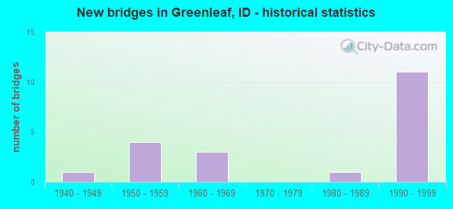
- New bridges - historical statistics
- 11940-1949
- 41950-1959
- 31960-1969
- 11980-1989
- 111990-1999

- Reconstructed bridges - Historical Statistics
- 21960-1969
- 21970-1979


- Bridge Condition - Deck
- 50.0%Good
- 45.0%Satisfactory
- 5.0%Fair

- Bridge Condition - Superstructure
- 5.0%Very good
- 30.0%Good
- 55.0%Satisfactory
- 5.0%Fair
- 5.0%Poor

- Bridge Condition - Substructure
- 15.0%Very good
- 55.0%Good
- 30.0%Satisfactory

- Bridge Condition - Channel
- 5.0%Excellent
- 25.0%Very good
- 70.0%Good
Find on map >> Show street view
Structure Number: 19681, Location: 7.9 E. HOMEDALE (Lat: 43.617639, Lng: -116.776972), Route carried "on" structure: County highway 3724, Year Built: 1991, Status: Open, Structure Length: 2.38m (7.81ft), Average Daily Traffic: 2,300 (year 2019), Truck Traffic: 8%, Average Future Daily Traffic: 3,450 (year 2039), Design Load: HS 20, Features Intersected: GOLDEN GATE LOW LINE CNL
Minimum Vertical Clearance: 30+ m (98+ ft), Kilometerpoint: 11.838, Lanes on structure: 2, Owner: Local Agency, Approaching Roadway Width: 8.5m (27.9ft), Skew: 1 degrees, Material/Design: Prestressed concrete, Design/Construction: Stringer/Multi-beam, Number Of Spans In Main Unit: 1, Length of Maximum Span: 23.5m (77.1ft), Curb or Sidewalk Widths: Left: 0.4m (1.3ft), Right: 0.4m (1.3ft), Curb-To-Curb Width: 8.5m (27.9ft), Out-to-Out Width: 10.0m (32.8ft)
Condition: Deck: Satisfactory, Superstructure: Very good, Substructure: Very good, Channel: Very good, Operating Rating: 61.7 metric tons, Method Used To Determine Operating Rating: Load Factor (LF), Inventory Rating: 35.4 metric tons, Method Used To Determine Inventory Rating: Load Factor (LF), Structural Evaluation: Equal to present desirable criteria, Deck Geometry: Meets minimum limits, Waterway Adequacy: Superior to present desirable criteria, Approach Roadway Alignment: Equal to present desirable criteria, Designated Inspection Frequency: Every 24 months, Inspection Date: March 2020, Deck Structure Type: Concrete Cast-file-Place, Wearing Surface/Protective System: Wearing Surface: Bituminous
Find on map >> Show street view
Structure Number: 197, Location: 3.0 S. NOTUS (Lat: 43.681778, Lng: -116.802861), Route carried "on" structure: County highway 3740, Year Built: 1940, Year Reconstructed: 1972, Status: Open, Structure Length: 0.73m (2.40ft), Average Daily Traffic: 1,600 (year 2019), Truck Traffic: 10%, Average Future Daily Traffic: 2,400 (year 2039), Design Load: H 15, Features Intersected: RIVERSIDE CANAL
Minimum Vertical Clearance: 30+ m (98+ ft), Kilometerpoint: 1.373, Lanes on structure: 2, Owner: Local Agency, Approaching Roadway Width: 8.8m (28.9ft), Material/Design: Prestressed concrete, Design/Construction: Stringer/Multi-beam, Number Of Spans In Main Unit: 1, Length of Maximum Span: 7.0m (23.0ft), Curb-To-Curb Width: 9.5m (31.2ft), Out-to-Out Width: 9.9m (32.5ft)
Condition: Deck: Good, Superstructure: Good, Substructure: Satisfactory, Channel: Good, Operating Rating: 34.5 metric tons, Method Used To Determine Operating Rating: Field evaluation and documented engineering judgment, Inventory Rating: 20.9 metric tons, Method Used To Determine Inventory Rating: Field evaluation and documented engineering judgment, Structural Evaluation: Somewhat better than minimum adequacy, Deck Geometry: Somewhat better than minimum adequacy, Waterway Adequacy: Better than present minimum criteria, Approach Roadway Alignment: Equal to present desirable criteria, Length Of Structure Improvement: 1.34m (4.40ft), Designated Inspection Frequency: Every 24 months, Inspection Date: October 2020, Bridge Improvement Cost: $63,000, Roadway Improvement Cost: $6,000, Total Project Cost: $95,000, Deck Structure Type: Concrete Cast-file-Place, Wearing Surface/Protective System: Wearing Surface: Bituminous
Find on map >> Show street view
Structure Number: 26746, Location: 3.0 S. 5.0 E. WILDER (Lat: 43.633139, Lng: -116.812611), Route carried "on" structure: County highway 3717, Year Built: 1995, Status: Open, Structure Length: 1.86m (6.10ft), Average Daily Traffic: 1,900 (year 2019), Truck Traffic: 10%, Average Future Daily Traffic: 2,850 (year 2039), Design Load: HS 20, Features Intersected: LOWLINE CANAL
Minimum Vertical Clearance: 30+ m (98+ ft), Kilometerpoint: 0.026, Lanes on structure: 2, Owner: Local Agency, Approaching Roadway Width: 4.6m (15.1ft), Material/Design: Concrete, Design/Construction: Channel Beam, Number Of Spans In Main Unit: 3, Length of Maximum Span: 5.5m (18.0ft), Curb or Sidewalk Widths: Left: 0.2m (0.7ft), Right: 0.2m (0.7ft), Curb-To-Curb Width: 10.2m (33.5ft), Out-to-Out Width: 10.9m (35.8ft)
Condition: Deck: Good, Superstructure: Good, Substructure: Good, Channel: Good, Operating Rating: 47.2 metric tons, Method Used To Determine Operating Rating: Field evaluation and documented engineering judgment, Inventory Rating: 28.1 metric tons, Method Used To Determine Inventory Rating: Field evaluation and documented engineering judgment, Structural Evaluation: Better than present minimum criteria, Deck Geometry: Somewhat better than minimum adequacy, Waterway Adequacy: Better than present minimum criteria, Approach Roadway Alignment: Better than present minimum criteria, Designated Inspection Frequency: Every 24 months, Inspection Date: November 2021, Deck Structure Type: Concrete Precast Panels, Wearing Surface/Protective System: Wearing Surface: Bituminous
Find on map >> Show street view
Structure Number: 2679, Location: 5.2 N. 1.5 E. MARSING (Lat: 43.621194, Lng: -116.782639), Route carried "on" structure: County highway , Year Built: 1956, Status: Open, Structure Length: 2.38m (7.81ft), Average Daily Traffic: 1,000 (year 2019), Truck Traffic: 5%, Average Future Daily Traffic: 1,500 (year 2039), Design Load: H 15, Features Intersected: GOLDEN GATE LOW LINE CNL, Facility Carried by Structure: PRIDE LANE
Minimum Vertical Clearance: 30+ m (98+ ft), Kilometerpoint: 164.562, Lanes on structure: 2, Owner: Local Agency, Approaching Roadway Width: 7.0m (23.0ft), Skew: 3 degrees, Material/Design: Concrete, Design/Construction: Stringer/Multi-beam, Number Of Spans In Main Unit: 3, Length of Maximum Span: 7.6m (24.9ft), Curb or Sidewalk Widths: Left: 0.3m (1.0ft), Right: 0.3m (1.0ft), Curb-To-Curb Width: 7.3m (24.0ft), Out-to-Out Width: 8.1m (26.6ft)
Condition: Deck: Satisfactory, Superstructure: Satisfactory, Substructure: Satisfactory, Channel: Very good, Operating Rating: 59.9 metric tons, Method Used To Determine Operating Rating: Load Factor (LF), Inventory Rating: 35.4 metric tons, Method Used To Determine Inventory Rating: Load Factor (LF), Structural Evaluation: Equal to present minimum criteria, Deck Geometry: Meets minimum limits, Waterway Adequacy: Equal to present desirable criteria, Approach Roadway Alignment: Equal to present desirable criteria, Length Of Structure Improvement: 3.14m (10.30ft), Designated Inspection Frequency: Every 48 months, Inspection Date: March 2021, Bridge Improvement Cost: $646,000, Roadway Improvement Cost: $65,000, Total Project Cost: $969,000 ( Estimate for 2021), Deck Structure Type: Concrete Cast-file-Place, Wearing Surface/Protective System: Wearing Surface: Bituminous
Find on map >> Show street view
Structure Number: 26815, Location: 2.0 S. 4.8 E. WILDER (Lat: 43.647556, Lng: -116.816556), Route carried "on" structure: County highway 3792, Year Built: 1950, Year Reconstructed: 1970, Status: Open, Structure Length: 1.22m (4.00ft), Average Daily Traffic: 260 (year 2019), Truck Traffic: 8%, Average Future Daily Traffic: 390 (year 2039), Design Load: HS 20, Features Intersected: DEER FLAT LOW LINE CANAL
Minimum Vertical Clearance: 30+ m (98+ ft), Kilometerpoint: 0.492, Lanes on structure: 2, Owner: Local Agency, Approaching Roadway Width: 7.6m (24.9ft), Skew: 2 degrees, Material/Design: Prestressed concrete, Design/Construction: Tee Beam, Number Of Spans In Main Unit: 1, Length of Maximum Span: 11.9m (39.0ft), Curb-To-Curb Width: 8.1m (26.6ft), Out-to-Out Width: 8.8m (28.9ft)
Condition: Deck: Satisfactory, Superstructure: Satisfactory, Substructure: Satisfactory, Channel: Very good, Operating Rating: 34.5 metric tons, Method Used To Determine Operating Rating: Field evaluation and documented engineering judgment, Inventory Rating: 20.9 metric tons, Method Used To Determine Inventory Rating: Field evaluation and documented engineering judgment, Structural Evaluation: Equal to present minimum criteria, Deck Geometry: Somewhat better than minimum adequacy, Waterway Adequacy: Equal to present desirable criteria, Approach Roadway Alignment: Better than present minimum criteria, Designated Inspection Frequency: Every 24 months, Inspection Date: November 2021, Deck Structure Type: Concrete Cast-file-Place, Wearing Surface/Protective System: Wearing Surface: Bituminous
Find on map >> Show street view
Structure Number: 26875, Location: 2.0 S. 5.0 E. WILDER (Lat: 43.647611, Lng: -116.811750), Route carried "on" structure: County highway 3792, Year Built: 1950, Year Reconstructed: 1970, Status: Open, Structure Length: 1.43m (4.69ft), Average Daily Traffic: 260 (year 2019), Truck Traffic: 8%, Average Future Daily Traffic: 390 (year 2039), Design Load: HS 20, Features Intersected: GOLDEN GATE CANAL
Minimum Vertical Clearance: 30+ m (98+ ft), Kilometerpoint: 0.879, Lanes on structure: 2, Owner: Local Agency, Approaching Roadway Width: 7.3m (24.0ft), Material/Design: Prestressed concrete, Design/Construction: Stringer/Multi-beam, Number Of Spans In Main Unit: 1, Length of Maximum Span: 14.0m (45.9ft), Curb-To-Curb Width: 8.0m (26.2ft), Out-to-Out Width: 8.6m (28.2ft)
Condition: Deck: Good, Superstructure: Satisfactory, Substructure: Good, Channel: Good, Operating Rating: 34.5 metric tons, Method Used To Determine Operating Rating: Field evaluation and documented engineering judgment, Inventory Rating: 20.9 metric tons, Method Used To Determine Inventory Rating: Field evaluation and documented engineering judgment, Structural Evaluation: Equal to present minimum criteria, Deck Geometry: Somewhat better than minimum adequacy, Waterway Adequacy: Better than present minimum criteria, Approach Roadway Alignment: Somewhat better than minimum adequacy, Length Of Structure Improvement: 2.04m (6.69ft), Designated Inspection Frequency: Every 24 months, Inspection Date: November 2021, Bridge Improvement Cost: $332,000, Roadway Improvement Cost: $33,000, Total Project Cost: $498,000 ( Estimate for 2021), Deck Structure Type: Concrete Cast-file-Place, Wearing Surface/Protective System: Wearing Surface: Bituminous
Find on map >> Show street view
Structure Number: 2695, Location: 1.2 N. 3.4 E. WILDER (Lat: 43.695194, Lng: -116.844361), Route carried "on" structure: County highway , Year Built: 1990, Status: Posted for load, Structure Length: 0.88m (2.89ft), Average Daily Traffic: 20 (year 2019), Truck Traffic: 5%, Average Future Daily Traffic: 30 (year 2039), Design Load: H 15, Features Intersected: DIXIE SLOUGH, Facility Carried by Structure: TUCKER ROAD
Minimum Vertical Clearance: 30+ m (98+ ft), Kilometerpoint: 168.353, Lanes on structure: 2, Owner: Local Agency, Approaching Roadway Width: 5.5m (18.0ft), Material/Design: Steel, Design/Construction: Stringer/Multi-beam, Number Of Spans In Main Unit: 1, Length of Maximum Span: 8.2m (26.9ft), Curb or Sidewalk Widths: Left: 0.1m (0.3ft), Right: 0.1m (0.3ft), Curb-To-Curb Width: 6.7m (22.0ft), Out-to-Out Width: 7.6m (24.9ft)
Condition: Deck: Satisfactory, Superstructure: Satisfactory, Substructure: Satisfactory, Channel: Good, Operating Rating: 20.9 metric tons, Method Used To Determine Operating Rating: Load Factor (LF), Inventory Rating: 15.4 metric tons, Method Used To Determine Inventory Rating: Load Factor (LF), Structural Evaluation: Meets minimum limits, Deck Geometry: Somewhat better than minimum adequacy, Waterway Adequacy: Better than present minimum criteria, Approach Roadway Alignment: Equal to present desirable criteria, Length Of Structure Improvement: 1.52m (4.99ft), Designated Inspection Frequency: Every 24 months, Inspection Date: October 2020, Bridge Improvement Cost: $231,000, Roadway Improvement Cost: $23,000, Total Project Cost: $347,000, Deck Structure Type: Wood or Timber, Wearing Surface/Protective System: Wearing Surface: Gravel
Find on map >> Show street view
Structure Number: 26956, Location: 1.1 N. 3.3 E. WILDER (Lat: 43.694839, Lng: -116.845600), Route carried "on" structure: County highway , Year Built: 1999, Status: Open, Structure Length: 0.91m (2.99ft), Average Daily Traffic: 20 (year 2019), Truck Traffic: 5%, Average Future Daily Traffic: 30 (year 2039), Design Load: HS 20, Features Intersected: RIVERSIDE CANAL, Facility Carried by Structure: TUCKER ROAD
Minimum Vertical Clearance: 30+ m (98+ ft), Kilometerpoint: 168.259, Lanes on structure: 2, Owner: Local Agency, Approaching Roadway Width: 6.1m (20.0ft), Material/Design: Concrete, Design/Construction: Frame, Number Of Spans In Main Unit: 1, Length of Maximum Span: 9.1m (29.9ft), Curb or Sidewalk Widths: Left: 0.2m (0.7ft), Right: 0.2m (0.7ft), Curb-To-Curb Width: 9.1m (29.9ft), Out-to-Out Width: 9.8m (32.2ft)
Condition: Deck: Satisfactory, Superstructure: Satisfactory, Substructure: Satisfactory, Channel: Good, Operating Rating: 47.2 metric tons, Method Used To Determine Operating Rating: Field evaluation and documented engineering judgment, Inventory Rating: 28.1 metric tons, Method Used To Determine Inventory Rating: Field evaluation and documented engineering judgment, Structural Evaluation: Equal to present minimum criteria, Deck Geometry: Better than present minimum criteria, Waterway Adequacy: Equal to present desirable criteria, Approach Roadway Alignment: Equal to present minimum criteria, Designated Inspection Frequency: Every 24 months, Inspection Date: October 2021, Deck Structure Type: Concrete Precast Panels, Wearing Surface/Protective System: Wearing Surface: Gravel
Find on map >> Show street view
Structure Number: 26961, Location: 7.0 S. 0.3 E. NOTUS (Lat: 43.620417, Lng: -116.792678), Route carried "on" structure: County highway , Year Built: 1992, Status: Open, Structure Length: 1.77m (5.81ft), Average Daily Traffic: 100 (year 2019), Truck Traffic: 5%, Average Future Daily Traffic: 150 (year 2039), Design Load: H 20, Features Intersected: LOW LINE CANAL, Facility Carried by Structure: BEET ROAD
Minimum Vertical Clearance: 30+ m (98+ ft), Kilometerpoint: 162.991, Lanes on structure: 2, Owner: Local Agency, Approaching Roadway Width: 5.2m (17.1ft), Material/Design: Wood or Timber, Design/Construction: Stringer/Multi-beam, Number Of Spans In Main Unit: 2, Length of Maximum Span: 8.5m (27.9ft), Curb-To-Curb Width: 9.2m (30.2ft), Out-to-Out Width: 9.4m (30.8ft)
Condition: Deck: Satisfactory, Superstructure: Satisfactory, Substructure: Good, Channel: Good, Operating Rating: 30.8 metric tons, Method Used To Determine Operating Rating: Allowable Stress (AS), Inventory Rating: 22.7 metric tons, Method Used To Determine Inventory Rating: Allowable Stress (AS), Structural Evaluation: Equal to present minimum criteria, Deck Geometry: Better than present minimum criteria, Waterway Adequacy: Equal to present desirable criteria, Approach Roadway Alignment: Equal to present desirable criteria, Designated Inspection Frequency: Every 24 months, Inspection Date: March 2021, Deck Structure Type: Wood or Timber, Wearing Surface/Protective System: Wearing Surface: Bituminous
Find on map >> Show street view
Structure Number: 2701, Location: 2.0 S. 3.2 E. WILDER (Lat: 43.647250, Lng: -116.848972), Route carried "on" structure: County highway 3792, Year Built: 1950, Year Reconstructed: 1972, Status: Posted for load, Structure Length: 1.13m (3.71ft), Average Daily Traffic: 190 (year 2019), Average Future Daily Traffic: 285 (year 2039), Design Load: H 10, Features Intersected: DEER FLAT CANAL
Minimum Vertical Clearance: 30+ m (98+ ft), Kilometerpoint: 169.264, Lanes on structure: 2, Owner: Local Agency, Approaching Roadway Width: 7.0m (23.0ft), Material/Design: Wood or Timber, Design/Construction: Stringer/Multi-beam, Number Of Spans In Main Unit: 2, Length of Maximum Span: 5.2m (17.1ft), Curb-To-Curb Width: 7.2m (23.6ft), Out-to-Out Width: 7.3m (24.0ft)
Condition: Deck: Satisfactory, Superstructure: Poor, Substructure: Satisfactory, Channel: Good, Operating Rating: 26.3 metric tons, Method Used To Determine Operating Rating: Allowable Stress (AS), Inventory Rating: 18.1 metric tons, Method Used To Determine Inventory Rating: Allowable Stress (AS), Structural Evaluation: Meets minimum limits, Deck Geometry: Meets minimum limits, Waterway Adequacy: Equal to present desirable criteria, Approach Roadway Alignment: Equal to present desirable criteria, Bridge Posting: Required (Relationship of Operating Rating to Maximum Legal Load: 10.0 - 19.9% below), Length Of Structure Improvement: 1.80m (5.91ft), Designated Inspection Frequency: Every 12 months, Inspection Date: November 2021, Bridge Improvement Cost: $292,000, Roadway Improvement Cost: $29,000, Total Project Cost: $438,000 ( Estimate for 2019), Deck Structure Type: Wood or Timber, Wearing Surface/Protective System: Wearing Surface: Bituminous
Find on map >> Show street view
Structure Number: 27061, Location: 2.0 S. 2.7 E. WILDER (Lat: 43.647167, Lng: -116.857333), Route carried "on" structure: County highway 3792, Year Built: 1989, Status: Posted for load, Structure Length: 1.46m (4.79ft), Average Daily Traffic: 190 (year 2019), Average Future Daily Traffic: 285 (year 2039), Design Load: HS 15, Features Intersected: DEER FLAT CANAL
Minimum Vertical Clearance: 30+ m (98+ ft), Kilometerpoint: 168.548, Lanes on structure: 2, Owner: Local Agency, Approaching Roadway Width: 4.9m (16.1ft), Material/Design: Wood or Timber, Design/Construction: Stringer/Multi-beam, Number Of Spans In Main Unit: 3, Length of Maximum Span: 4.8m (15.7ft), Curb or Sidewalk Widths: Left: 0.1m (0.3ft), Right: 0.1m (0.3ft), Curb-To-Curb Width: 6.6m (21.7ft), Out-to-Out Width: 6.9m (22.6ft)
Condition: Deck: Fair, Superstructure: Fair, Substructure: Good, Channel: Very good, Operating Rating: 22.7 metric tons, Method Used To Determine Operating Rating: Load Factor (LF), Inventory Rating: 17.2 metric tons, Method Used To Determine Inventory Rating: Load Factor (LF), Structural Evaluation: Somewhat better than minimum adequacy, Deck Geometry: Meets minimum limits, Waterway Adequacy: Equal to present desirable criteria, Approach Roadway Alignment: Better than present minimum criteria, Length Of Structure Improvement: 2.16m (7.09ft), Designated Inspection Frequency: Every 24 months, Inspection Date: November 2021, Bridge Improvement Cost: $351,000, Roadway Improvement Cost: $35,000, Total Project Cost: $527,000 ( Estimate for 2019), Deck Structure Type: Wood or Timber, Wearing Surface/Protective System: Wearing Surface: Bituminous
Find on map >> Show street view
Structure Number: 27071, Location: 2.2 S. 3.0 E. WILDER (Lat: 43.645139, Lng: -116.852528), Route carried "on" structure: County highway , Year Built: 1992, Status: Open, Structure Length: 1.62m (5.31ft), Average Daily Traffic: 30 (year 2019), Truck Traffic: 10%, Average Future Daily Traffic: 45 (year 2039), Design Load: HS 20, Features Intersected: DEER FLAT CANAL, Facility Carried by Structure: VAN SLYKE ROAD
Minimum Vertical Clearance: 30+ m (98+ ft), Kilometerpoint: 164.048, Lanes on structure: 2, Owner: Local Agency, Approaching Roadway Width: 8.5m (27.9ft), Skew: 1 degrees, Material/Design: Concrete, Design/Construction: Stringer/Multi-beam, Number Of Spans In Main Unit: 3, Length of Maximum Span: 5.2m (17.1ft), Curb or Sidewalk Widths: Left: 0.2m (0.7ft), Right: 0.2m (0.7ft), Curb-To-Curb Width: 8.0m (26.2ft), Out-to-Out Width: 8.5m (27.9ft)
Condition: Deck: Good, Superstructure: Good, Substructure: Very good, Channel: Good, Operating Rating: 54.4 metric tons, Method Used To Determine Operating Rating: Field evaluation and documented engineering judgment, Inventory Rating: 32.7 metric tons, Method Used To Determine Inventory Rating: Field evaluation and documented engineering judgment, Structural Evaluation: Better than present minimum criteria, Deck Geometry: Equal to present minimum criteria, Waterway Adequacy: Equal to present desirable criteria, Approach Roadway Alignment: Equal to present desirable criteria, Designated Inspection Frequency: Every 24 months, Inspection Date: November 2020, Deck Structure Type: Concrete Precast Panels, Wearing Surface/Protective System: Wearing Surface: Bituminous
Find on map >> Show street view
Structure Number: 27086, Location: 2.0 S. 2.5 E. WILDER (Lat: 43.647139, Lng: -116.861556), Route carried "on" structure: County highway 3792, Year Built: 1997, Status: Open, Structure Length: 1.55m (5.09ft), Average Daily Traffic: 190 (year 2019), Average Future Daily Traffic: 285 (year 2039), Design Load: HS 20, Features Intersected: DEER FLAT CANAL
Minimum Vertical Clearance: 30+ m (98+ ft), Kilometerpoint: 168.204, Lanes on structure: 2, Owner: Local Agency, Approaching Roadway Width: 5.8m (19.0ft), Skew: 1 degrees, Material/Design: Concrete, Design/Construction: Channel Beam, Number Of Spans In Main Unit: 3, Length of Maximum Span: 4.9m (16.1ft), Curb or Sidewalk Widths: Left: 0.2m (0.7ft), Right: 0.2m (0.7ft), Curb-To-Curb Width: 9.1m (29.9ft), Out-to-Out Width: 9.6m (31.5ft)
Condition: Deck: Satisfactory, Superstructure: Satisfactory, Substructure: Good, Channel: Good, Operating Rating: 54.4 metric tons, Method Used To Determine Operating Rating: Field evaluation and documented engineering judgment, Inventory Rating: 32.7 metric tons, Method Used To Determine Inventory Rating: Field evaluation and documented engineering judgment, Structural Evaluation: Equal to present minimum criteria, Deck Geometry: Equal to present minimum criteria, Waterway Adequacy: Better than present minimum criteria, Approach Roadway Alignment: Equal to present desirable criteria, Designated Inspection Frequency: Every 24 months, Inspection Date: Febuary 2020, Deck Structure Type: Concrete Precast Panels, Wearing Surface/Protective System: Wearing Surface: Bituminous
Find on map >> Show street view
Structure Number: 2717, Location: 1.9 S. 4.5 E. WILDER (Lat: 43.649889, Lng: -116.822639), Route carried "on" structure: County highway 3717, Year Built: 1961, Status: Open, Structure Length: 1.58m (5.18ft), Average Daily Traffic: 440 (year 2019), Truck Traffic: 23%, Average Future Daily Traffic: 660 (year 2039), Design Load: H 15, Features Intersected: DEER FLAT LOW LINE CANAL
Minimum Vertical Clearance: 30+ m (98+ ft), Kilometerpoint: 163.989, Lanes on structure: 2, Owner: Local Agency, Approaching Roadway Width: 7.3m (24.0ft), Material/Design: Concrete, Design/Construction: Stringer/Multi-beam, Number Of Spans In Main Unit: 2, Length of Maximum Span: 7.6m (24.9ft), Curb or Sidewalk Widths: Left: 0.3m (1.0ft), Right: 0.3m (1.0ft), Curb-To-Curb Width: 7.4m (24.3ft), Out-to-Out Width: 8.1m (26.6ft)
Condition: Deck: Good, Superstructure: Satisfactory, Substructure: Good, Channel: Good, Operating Rating: 64.4 metric tons, Method Used To Determine Operating Rating: Load Factor (LF), Inventory Rating: 38.1 metric tons, Method Used To Determine Inventory Rating: Load Factor (LF), Structural Evaluation: Equal to present minimum criteria, Deck Geometry: Meets minimum limits, Waterway Adequacy: Equal to present desirable criteria, Approach Roadway Alignment: Equal to present desirable criteria, Designated Inspection Frequency: Every 48 months, Inspection Date: November 2019, Deck Structure Type: Concrete Cast-file-Place, Wearing Surface/Protective System: Wearing Surface: Bituminous
Find on map >> Show street view
Structure Number: 27206, Location: 0.8 S. 3.0 E. WILDER (Lat: 43.664472, Lng: -116.852500), Route carried "on" structure: County highway , Year Built: 1994, Status: Open, Structure Length: 1.19m (3.90ft), Average Daily Traffic: 80 (year 2019), Truck Traffic: 5%, Average Future Daily Traffic: 120 (year 2039), Design Load: HS 20, Features Intersected: GOLDEN GATE CANAL, Facility Carried by Structure: VAN SLYKE ROAD
Minimum Vertical Clearance: 30+ m (98+ ft), Kilometerpoint: 166.158, Lanes on structure: 2, Owner: Local Agency, Approaching Roadway Width: 6.7m (22.0ft), Skew: 1 degrees, Material/Design: Concrete, Design/Construction: Channel Beam, Number Of Spans In Main Unit: 2, Length of Maximum Span: 5.8m (19.0ft), Curb or Sidewalk Widths: Left: 0.2m (0.7ft), Right: 0.2m (0.7ft), Curb-To-Curb Width: 8.0m (26.2ft), Out-to-Out Width: 8.5m (27.9ft)
Condition: Deck: Good, Superstructure: Good, Substructure: Good, Channel: Very good, Operating Rating: 54.4 metric tons, Method Used To Determine Operating Rating: Field evaluation and documented engineering judgment, Inventory Rating: 32.7 metric tons, Method Used To Determine Inventory Rating: Field evaluation and documented engineering judgment, Structural Evaluation: Better than present minimum criteria, Deck Geometry: Equal to present minimum criteria, Waterway Adequacy: Better than present minimum criteria, Approach Roadway Alignment: Equal to present desirable criteria, Designated Inspection Frequency: Every 24 months, Inspection Date: October 2020, Deck Structure Type: Concrete Precast Panels, Wearing Surface/Protective System: Wearing Surface: Bituminous
Find on map >> Show street view
Structure Number: 27245, Location: 1.1 S. 4.5 E. WILDER (Lat: 43.660972, Lng: -116.822694), Route carried "on" structure: County highway 3717, Year Built: 1967, Status: Open, Structure Length: 1.62m (5.31ft), Average Daily Traffic: 440 (year 2019), Truck Traffic: 23%, Average Future Daily Traffic: 660 (year 2039), Design Load: H 15, Features Intersected: GOLDEN GATE CANAL
Minimum Vertical Clearance: 30+ m (98+ ft), Kilometerpoint: 164.935, Lanes on structure: 2, Owner: Local Agency, Approaching Roadway Width: 5.8m (19.0ft), Material/Design: Concrete, Design/Construction: Stringer/Multi-beam, Number Of Spans In Main Unit: 2, Length of Maximum Span: 7.9m (25.9ft), Curb or Sidewalk Widths: Left: 0.3m (1.0ft), Right: 0.3m (1.0ft), Curb-To-Curb Width: 7.4m (24.3ft), Out-to-Out Width: 8.1m (26.6ft)
Condition: Deck: Good, Superstructure: Satisfactory, Substructure: Good, Channel: Good, Operating Rating: 62.6 metric tons, Method Used To Determine Operating Rating: Load Factor (LF), Inventory Rating: 37.2 metric tons, Method Used To Determine Inventory Rating: Load Factor (LF), Structural Evaluation: Equal to present minimum criteria, Waterway Adequacy: Equal to present desirable criteria, Approach Roadway Alignment: Equal to present desirable criteria, Designated Inspection Frequency: Every 48 months, Inspection Date: November 2019, Deck Structure Type: Concrete Cast-file-Place, Wearing Surface/Protective System: Wearing Surface: Bituminous
Find on map >> Show street view
Structure Number: 2729, Location: 1.1 S. 4.0 E. WILDER (Lat: 43.660694, Lng: -116.832611), Route carried "on" structure: County highway , Year Built: 1965, Status: Open, Structure Length: 1.34m (4.40ft), Average Daily Traffic: 70 (year 2019), Truck Traffic: 10%, Average Future Daily Traffic: 105 (year 2039), Design Load: HS 20, Features Intersected: GOLDEN GATE CANAL, Facility Carried by Structure: TUCKER ROAD
Minimum Vertical Clearance: 30+ m (98+ ft), Kilometerpoint: 163.229, Lanes on structure: 2, Owner: Local Agency, Approaching Roadway Width: 6.1m (20.0ft), Skew: 3 degrees, Material/Design: Prestressed concrete, Design/Construction: Tee Beam, Number Of Spans In Main Unit: 2, Length of Maximum Span: 6.4m (21.0ft), Curb-To-Curb Width: 7.9m (25.9ft), Out-to-Out Width: 8.5m (27.9ft)
Condition: Deck: Good, Superstructure: Satisfactory, Substructure: Good, Channel: Good, Operating Rating: 34.5 metric tons, Method Used To Determine Operating Rating: Field evaluation and documented engineering judgment, Inventory Rating: 20.9 metric tons, Method Used To Determine Inventory Rating: Field evaluation and documented engineering judgment, Structural Evaluation: Equal to present minimum criteria, Deck Geometry: Equal to present minimum criteria, Waterway Adequacy: Better than present minimum criteria, Approach Roadway Alignment: Better than present minimum criteria, Designated Inspection Frequency: Every 24 months, Inspection Date: March 2020, Deck Structure Type: Concrete Cast-file-Place, Wearing Surface/Protective System: Wearing Surface: Bituminous
Find on map >> Show street view
Structure Number: 27346, Location: 3.5 S. 5.5 E. WILDER (Lat: 43.624889, Lng: -116.799833), Route carried "on" structure: County highway , Year Built: 1996, Status: Open, Structure Length: 1.89m (6.20ft), Average Daily Traffic: 50 (year 2019), Truck Traffic: 5%, Average Future Daily Traffic: 75 (year 2039), Design Load: HS 20, Features Intersected: LOWLINE CANAL, Facility Carried by Structure: LONKEY LANE
Minimum Vertical Clearance: 30+ m (98+ ft), Kilometerpoint: 162.761, Lanes on structure: 2, Owner: Local Agency, Approaching Roadway Width: 6.4m (21.0ft), Skew: 2 degrees, Material/Design: Concrete, Design/Construction: Channel Beam, Number Of Spans In Main Unit: 3, Length of Maximum Span: 6.1m (20.0ft), Curb or Sidewalk Widths: Left: 0.2m (0.7ft), Right: 0.2m (0.7ft), Curb-To-Curb Width: 9.1m (29.9ft), Out-to-Out Width: 9.6m (31.5ft)
Condition: Deck: Good, Superstructure: Good, Substructure: Very good, Channel: Excellent, Operating Rating: 54.4 metric tons, Method Used To Determine Operating Rating: Field evaluation and documented engineering judgment, Inventory Rating: 32.7 metric tons, Method Used To Determine Inventory Rating: Field evaluation and documented engineering judgment, Structural Evaluation: Better than present minimum criteria, Deck Geometry: Better than present minimum criteria, Waterway Adequacy: Superior to present desirable criteria, Approach Roadway Alignment: Equal to present desirable criteria, Designated Inspection Frequency: Every 24 months, Inspection Date: October 2020, Deck Structure Type: Concrete Precast Panels, Wearing Surface/Protective System: Wearing Surface: Bituminous
Find on map >> Show street view
Structure Number: 27356, Location: 1.0 S. 4.0 E. WILDER (Lat: 43.649200, Lng: -116.832564), Route carried "on" structure: County highway , Year Built: 1997, Status: Open, Structure Length: 1.68m (5.51ft), Average Daily Traffic: 70 (year 2019), Truck Traffic: 10%, Average Future Daily Traffic: 105 (year 2039), Design Load: HS 20, Features Intersected: LOW LINE CANAL, Facility Carried by Structure: TUCKER ROAD
Minimum Vertical Clearance: 30+ m (98+ ft), Kilometerpoint: 161.956, Lanes on structure: 2, Owner: Local Agency, Approaching Roadway Width: 5.8m (19.0ft), Skew: 2 degrees, Material/Design: Concrete, Design/Construction: Stringer/Multi-beam, Number Of Spans In Main Unit: 3, Length of Maximum Span: 5.2m (17.1ft), Curb or Sidewalk Widths: Left: 0.2m (0.7ft), Right: 0.2m (0.7ft), Curb-To-Curb Width: 9.1m (29.9ft), Out-to-Out Width: 9.6m (31.5ft)
Condition: Deck: Satisfactory, Superstructure: Satisfactory, Substructure: Good, Channel: Good, Operating Rating: 54.4 metric tons, Method Used To Determine Operating Rating: Field evaluation and documented engineering judgment, Inventory Rating: 32.7 metric tons, Method Used To Determine Inventory Rating: Field evaluation and documented engineering judgment, Structural Evaluation: Equal to present minimum criteria, Deck Geometry: Better than present minimum criteria, Waterway Adequacy: Superior to present desirable criteria, Approach Roadway Alignment: Better than present minimum criteria, Designated Inspection Frequency: Every 24 months, Inspection Date: March 2021, Deck Structure Type: Concrete Precast Panels, Wearing Surface/Protective System: Wearing Surface: Bituminous
Find on map >> Show street view
Structure Number: 27386, Location: 1.0 S. 3.8 E. WILDER (Lat: 43.661944, Lng: -116.837028), Route carried "on" structure: County highway , Year Built: 1994, Status: Open, Structure Length: 1.77m (5.81ft), Average Daily Traffic: 80 (year 2019), Truck Traffic: 5%, Average Future Daily Traffic: 120 (year 2039), Design Load: HS 20, Features Intersected: GOLDEN GATE CANAL, Facility Carried by Structure: LOW PLEASANT RD
Minimum Vertical Clearance: 30+ m (98+ ft), Kilometerpoint: 170.967, Lanes on structure: 2, Owner: Local Agency, Approaching Roadway Width: 4.9m (16.1ft), Skew: 4 degrees, Material/Design: Concrete, Design/Construction: Channel Beam, Number Of Spans In Main Unit: 3, Length of Maximum Span: 5.8m (19.0ft), Curb or Sidewalk Widths: Left: 0.2m (0.7ft), Right: 0.2m (0.7ft), Curb-To-Curb Width: 8.0m (26.2ft), Out-to-Out Width: 8.5m (27.9ft)
Condition: Deck: Good, Superstructure: Good, Substructure: Good, Channel: Good, Operating Rating: 54.4 metric tons, Method Used To Determine Operating Rating: Field evaluation and documented engineering judgment, Inventory Rating: 32.7 metric tons, Method Used To Determine Inventory Rating: Field evaluation and documented engineering judgment, Structural Evaluation: Better than present minimum criteria, Deck Geometry: Equal to present minimum criteria, Waterway Adequacy: Better than present minimum criteria, Approach Roadway Alignment: Equal to present desirable criteria, Designated Inspection Frequency: Every 24 months, Inspection Date: October 2020, Deck Structure Type: Concrete Precast Panels, Wearing Surface/Protective System: Wearing Surface: Bituminous