Bridge Statistics for Greens Fork, Indiana (IN)
Condition, Traffic, Stress, Structural Evaluation, Project Costs
- National Bridge Inventory (NBI) Statistics
- 22Number of bridges
- 279ft / 84.9mTotal length
- 120,295Total average daily traffic
- 39,115Total average daily truck traffic
- National Bridge Inventory (NBI) Registered Bridges for Greens Fork
- No street view available for this location
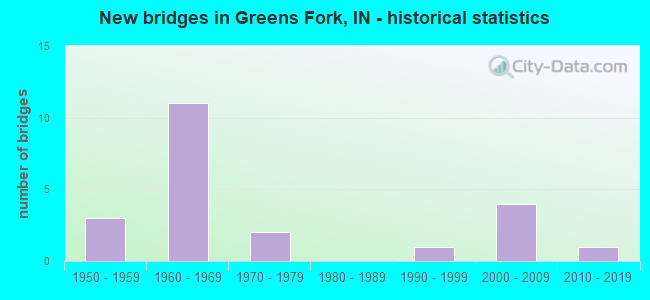
- New bridges - historical statistics
- 31950-1959
- 111960-1969
- 21970-1979
- 11990-1999
- 42000-2009
- 12010-2019

- Reconstructed bridges - Historical Statistics
- 11970-1979
- 21980-1989
- 21990-1999


- Bridge Condition - Deck
- 18.8%Very good
- 12.5%Good
- 43.8%Satisfactory
- 18.8%Fair
- 6.3%Poor

- Bridge Condition - Superstructure
- 12.5%Very good
- 43.8%Good
- 37.5%Satisfactory
- 6.3%Fair

- Bridge Condition - Substructure
- 25.0%Very good
- 37.5%Good
- 31.3%Satisfactory
- 6.3%Fair

- Bridge Condition - Channel
- 6.3%Very good
- 25.0%Good
- 50.0%Satisfactory
- 18.8%Fair

- Bridge Condition - Culverts
- 50.0%Very good
- 50.0%Poor
Find on map >> Show street view
Structure Number: 1299, Location: 03.17 E SR 1 (Lat: 39.899781, Lng: -85.087719), Route carried "on" structure: State highway 38, Year Built: 1950, Status: Open, Structure Length: 1.98m (6.50ft), Average Daily Traffic: 7,301 (year 2004), Truck Traffic: 10%, Average Future Daily Traffic: 12,120 (year 2029), Design Load: HS 20, Features Intersected: MORGAN CREEK
Minimum Vertical Clearance: 30+ m (98+ ft), Kilometerpoint: 10.171, Lanes on structure: 2, Owner: State Highway Agency, Approaching Roadway Width: 8.5m (27.9ft), Material/Design: Concrete, Design/Construction: Culvert, Number Of Spans In Main Unit: 1, Length of Maximum Span: 19.8m (65.0ft), Curb or Sidewalk Widths: Left: 0.3m (1.0ft), Right: 0.3m (1.0ft), Curb-To-Curb Width: 8.5m (27.9ft), Out-to-Out Width: 9.9m (32.5ft)
Condition: Channel: Satisfactory, Culverts: Poor, Operating Rating: 97.3 metric tons, Method Used To Determine Operating Rating: Load and Resistance Factor (LRFR), Inventory Rating: 96.0 metric tons, Method Used To Determine Inventory Rating: Load and Resistance Factor (LRFR), Structural Evaluation: Meets minimum limits, Deck Geometry: High priority of replacement, Waterway Adequacy: Superior to present desirable criteria, Approach Roadway Alignment: Equal to present desirable criteria, Designated Inspection Frequency: Every 12 months, Inspection Date: August 2021
Find on map >> Show street view
Structure Number: 13, Location: 05.55 E SR 1 (Lat: 39.893019, Lng: -85.044169), Route carried "on" structure: State highway 38, Year Built: 1957, Year Reconstructed: 2003, Status: Open, Structure Length: 5.96m (19.55ft), Average Daily Traffic: 7,301 (year 2004), Truck Traffic: 10%, Average Future Daily Traffic: 15,000 (year 2030), Design Load: HS 20+Mod, Features Intersected: GREENS FORK
Minimum Vertical Clearance: 30+ m (98+ ft), Kilometerpoint: 14.001, Lanes on structure: 2, Owner: State Highway Agency, Approaching Roadway Width: 9.8m (32.2ft), Material/Design: Steel continuous, Design/Construction: Stringer/Multi-beam, Number Of Spans In Main Unit: 3, Length of Maximum Span: 21.9m (71.9ft), Curb-To-Curb Width: 10.8m (35.4ft), Out-to-Out Width: 11.7m (38.4ft)
Condition: Deck: Satisfactory, Superstructure: Good, Substructure: Good, Channel: Satisfactory, Operating Rating: 51.2 metric tons, Method Used To Determine Operating Rating: Load Factor (LF), Inventory Rating: 30.7 metric tons, Method Used To Determine Inventory Rating: Load Factor (LF), Structural Evaluation: Better than present minimum criteria, Deck Geometry: Meets minimum limits, Waterway Adequacy: Equal to present minimum criteria, Approach Roadway Alignment: Equal to present desirable criteria, Designated Inspection Frequency: Every 24 months, Inspection Date: August 2020, Deck Structure Type: Concrete Cast-file-Place, Wearing Surface/Protective System: Wearing Surface: Latex Concrete
Find on map >> Show street view
Structure Number: 434, Location: 03.81 E SR 1 (Lat: 39.853089, Lng: -85.073039), Route carried "on" structure: Interstate 70, Year Built: 1962, Year Reconstructed: 1987, Status: Open, Structure Length: 8.66m (28.41ft), Average Daily Traffic: 20,025 (year 2004), Truck Traffic: 10%, Average Future Daily Traffic: 37,000 (year 2031), Design Load: HS 20+Mod, Features Intersected: GREENS FORK
Minimum Vertical Clearance: 30+ m (98+ ft), Kilometerpoint: 226.483, Lanes on structure: 2, Base Highway Network: Yes (, Subroute: 1), Owner: State Highway Agency, Approaching Roadway Width: 11.6m (38.1ft), Skew: 2 degrees, Material/Design: Steel continuous, Design/Construction: Stringer/Multi-beam, Number Of Spans In Main Unit: 5, Length of Maximum Span: 18.3m (60.0ft), Curb-To-Curb Width: 11.9m (39.0ft), Out-to-Out Width: 12.8m (42.0ft)
Condition: Deck: Satisfactory, Superstructure: Good, Substructure: Satisfactory, Channel: Satisfactory, Operating Rating: 47.3 metric tons, Method Used To Determine Operating Rating: Load and Resistance Factor Rating (LRFR) rating reported by rating factor(RF) method using HL-93 loadings, Inventory Rating: 36.6 metric tons, Method Used To Determine Inventory Rating: Load and Resistance Factor Rating (LRFR) rating reported by rating factor(RF) method using HL-93 loadings, Structural Evaluation: Equal to present minimum criteria, Deck Geometry: Equal to present minimum criteria, Waterway Adequacy: Superior to present desirable criteria, Approach Roadway Alignment: Equal to present desirable criteria, Designated Inspection Frequency: Every 24 months, Inspection Date: December 2021, Deck Structure Type: Concrete Cast-file-Place, Wearing Surface/Protective System: Wearing Surface: Monolithic Concrete, Deck Protection: Epoxy Coated Reinforcing
Find on map >> Show street view
Structure Number: 4341, Location: 03.81 E SR 1 (Lat: 39.853319, Lng: -85.072900), Route carried "on" structure: Interstate 70, Year Built: 1962, Year Reconstructed: 1987, Status: Open, Structure Length: 8.66m (28.41ft), Average Daily Traffic: 20,025 (year 2004), Truck Traffic: 10%, Average Future Daily Traffic: 37,000 (year 2031), Design Load: HS 20+Mod, Features Intersected: GREENS FORK
Minimum Vertical Clearance: 30+ m (98+ ft), Kilometerpoint: 226.483, Lanes on structure: 2, Base Highway Network: Yes (, Subroute: 1), Owner: State Highway Agency, Approaching Roadway Width: 11.6m (38.1ft), Skew: 2 degrees, Material/Design: Steel continuous, Design/Construction: Stringer/Multi-beam, Number Of Spans In Main Unit: 5, Length of Maximum Span: 18.3m (60.0ft), Curb-To-Curb Width: 11.9m (39.0ft), Out-to-Out Width: 12.8m (42.0ft)
Condition: Deck: Satisfactory, Superstructure: Good, Substructure: Satisfactory, Channel: Fair, Operating Rating: 47.3 metric tons, Method Used To Determine Operating Rating: Load and Resistance Factor Rating (LRFR) rating reported by rating factor(RF) method using HL-93 loadings, Inventory Rating: 36.6 metric tons, Method Used To Determine Inventory Rating: Load and Resistance Factor Rating (LRFR) rating reported by rating factor(RF) method using HL-93 loadings, Structural Evaluation: Equal to present minimum criteria, Deck Geometry: Equal to present minimum criteria, Waterway Adequacy: Superior to present desirable criteria, Approach Roadway Alignment: Equal to present desirable criteria, Designated Inspection Frequency: Every 24 months, Inspection Date: December 2021, Deck Structure Type: Concrete Cast-file-Place, Wearing Surface/Protective System: Wearing Surface: Monolithic Concrete, Deck Protection: Epoxy Coated Reinforcing
Find on map >> Show street view
Structure Number: 4342, Location: 03.94 E SR 1 (Lat: 39.853119, Lng: -85.070531), Route carried "on" structure: Alternate County highway , Year Built: 1962, Year Reconstructed: 1990, Status: Open, Structure Length: 6.39m (20.96ft), Average Daily Traffic: 206 (year 2015), Truck Traffic: 10%, Average Future Daily Traffic: 400 (year 2031), Design Load: HS 20, Features Intersected: I-70 EB/WB, Facility Carried by Structure: WASHINGTON ROAD
Minimum Vertical Clearance: 30+ m (98+ ft), Kilometerpoint: 0.000, Lanes on structure: 2, Lanes under structure: 4, Owner: State Highway Agency, Approaching Roadway Width: 6.1m (20.0ft), Material/Design: Steel continuous, Design/Construction: Stringer/Multi-beam, Number Of Spans In Main Unit: 2, Number Of Approach Spans: 2, Length of Maximum Span: 19.8m (65.0ft), Curb-To-Curb Width: 8.0m (26.2ft), Out-to-Out Width: 8.9m (29.2ft)
Condition: Deck: Poor, Superstructure: Good, Substructure: Satisfactory, Operating Rating: 61.7 metric tons, Method Used To Determine Operating Rating: Load Factor (LF), Inventory Rating: 37.0 metric tons, Method Used To Determine Inventory Rating: Load Factor (LF), Structural Evaluation: Equal to present minimum criteria, Deck Geometry: Somewhat better than minimum adequacy, Underclear: High priority of corrective action, Approach Roadway Alignment: Equal to present desirable criteria, Designated Inspection Frequency: Every 12 months, Inspection Date: December 2021, Deck Structure Type: Concrete Cast-file-Place, Wearing Surface/Protective System: Wearing Surface: Latex Concrete
Find on map >> Show street view
Structure Number: 4343, Location: 05.48 E SR 1 (Lat: 39.858381, Lng: -85.042819), Route carried "on" structure: County highway , Year Built: 1962, Year Reconstructed: 1983, Status: Open, Structure Length: 6.58m (21.59ft), Average Daily Traffic: 314 (year 2004), Truck Traffic: 10%, Average Future Daily Traffic: 500 (year 2031), Design Load: HS 20, Features Intersected: I-70 EB/WB, Facility Carried by Structure: MINERAL SPRINGS RD
Minimum Vertical Clearance: 30+ m (98+ ft), Kilometerpoint: 0.000, Lanes on structure: 2, Lanes under structure: 4, Owner: State Highway Agency, Approaching Roadway Width: 6.1m (20.0ft), Skew: 1 degrees, Material/Design: Steel continuous, Design/Construction: Stringer/Multi-beam, Number Of Spans In Main Unit: 2, Number Of Approach Spans: 2, Length of Maximum Span: 20.4m (66.9ft), Curb or Sidewalk Widths: Left: 0.5m (1.6ft), Right: 0.5m (1.6ft), Curb-To-Curb Width: 7.3m (24.0ft), Out-to-Out Width: 8.9m (29.2ft)
Condition: Deck: Fair, Superstructure: Satisfactory, Substructure: Satisfactory, Operating Rating: 55.0 metric tons, Method Used To Determine Operating Rating: Load Factor (LF), Inventory Rating: 32.9 metric tons, Method Used To Determine Inventory Rating: Load Factor (LF), Structural Evaluation: Equal to present minimum criteria, Deck Geometry: Somewhat better than minimum adequacy, Underclear: Meets minimum limits, Approach Roadway Alignment: Equal to present desirable criteria, Designated Inspection Frequency: Every 24 months, Inspection Date: December 2021, Deck Structure Type: Concrete Cast-file-Place, Wearing Surface/Protective System: Wearing Surface: Latex Concrete
Find on map >> Show street view
Structure Number: 8900055, Location: 00.50 E of DOUGHERTY Rd (Lat: 39.849181, Lng: -85.080289), Route carried "on" structure: County highway , Year Built: 1971, Status: Open, Structure Length: 5.05m (16.57ft), Average Daily Traffic: 330 (year 2016), Truck Traffic: 5%, Average Future Daily Traffic: 445 (year 2036), Design Load: HS 20, Features Intersected: GREENS FORK, Facility Carried by Structure: KEPLER RD
Minimum Vertical Clearance: 30+ m (98+ ft), Kilometerpoint: 0.000, Lanes on structure: 2, Owner: County Highway Agency, Approaching Roadway Width: 6.1m (20.0ft), Skew: 1 degrees, Material/Design: Prestressed concrete, Design/Construction: Box Beam or Girders - Multiple, Number Of Spans In Main Unit: 3, Length of Maximum Span: 16.2m (53.1ft), Curb-To-Curb Width: 8.6m (28.2ft), Out-to-Out Width: 9.4m (30.8ft)
Condition: Deck: Satisfactory, Superstructure: Satisfactory, Substructure: Good, Channel: Satisfactory, Operating Rating: 47.3 metric tons, Method Used To Determine Operating Rating: Load Factor (LF), Inventory Rating: 28.4 metric tons, Method Used To Determine Inventory Rating: Load Factor (LF), Structural Evaluation: Equal to present minimum criteria, Deck Geometry: Equal to present minimum criteria, Waterway Adequacy: Better than present minimum criteria, Approach Roadway Alignment: Equal to present desirable criteria, Designated Inspection Frequency: Every 24 months, Inspection Date: May 2020, Deck Structure Type: Concrete Precast Panels, Wearing Surface/Protective System: Wearing Surface: Bituminous
Find on map >> Show street view
Structure Number: 8900056, Location: 00.10 W of WASHINGTON Rd (Lat: 39.856861, Lng: -85.071881), Route carried "on" structure: Alternate County highway , Year Built: 2005, Status: Open, Structure Length: 5.43m (17.81ft), Average Daily Traffic: 46 (year 2016), Average Future Daily Traffic: 63 (year 2036), Design Load: HS 20, Features Intersected: GREENS FORK, Facility Carried by Structure: MOYER RD
Minimum Vertical Clearance: 30+ m (98+ ft), Kilometerpoint: 0.000, Lanes on structure: 2, Owner: County Highway Agency, Approaching Roadway Width: 6.1m (20.0ft), Skew: 1 degrees, Material/Design: Prestressed concrete continuous, Design/Construction: Stringer/Multi-beam, Number Of Spans In Main Unit: 3, Length of Maximum Span: 18.1m (59.4ft), Curb-To-Curb Width: 8.4m (27.6ft), Out-to-Out Width: 8.6m (28.2ft)
Condition: Deck: Very good, Superstructure: Satisfactory, Substructure: Very good, Channel: Satisfactory, Operating Rating: 74.8 metric tons, Method Used To Determine Operating Rating: Load Factor (LF), Inventory Rating: 40.5 metric tons, Method Used To Determine Inventory Rating: Load Factor (LF), Structural Evaluation: Equal to present minimum criteria, Deck Geometry: Equal to present minimum criteria, Waterway Adequacy: Equal to present desirable criteria, Approach Roadway Alignment: Equal to present desirable criteria, Designated Inspection Frequency: Every 24 months, Inspection Date: April 2020, Deck Structure Type: Concrete Cast-file-Place, Wearing Surface/Protective System: Wearing Surface: Monolithic Concrete, Deck Protection: Epoxy Coated Reinforcing
Find on map >> Show street view
Structure Number: 8900057, Location: 00.60 E of JACKSONBURG Rd (Lat: 39.860089, Lng: -85.095639), Route carried "on" structure: Alternate County highway , Year Built: 2003, Status: Open, Structure Length: 0.78m (2.56ft), Average Daily Traffic: 81 (year 2016), Average Future Daily Traffic: 110 (year 2036), Features Intersected: DRY Branch CREEK, Facility Carried by Structure: MOYER RD
Minimum Vertical Clearance: 30+ m (98+ ft), Kilometerpoint: 0.000, Lanes on structure: 2, Owner: County Highway Agency, Approaching Roadway Width: 6.1m (20.0ft), Material/Design: Concrete, Design/Construction: Culvert, Number Of Spans In Main Unit: 1, Length of Maximum Span: 7.3m (24.0ft), Curb-To-Curb Width: 7.9m (25.9ft), Out-to-Out Width: 7.9m (25.9ft)
Condition: Channel: Good, Culverts: Very good, Operating Rating: 54.5 metric tons, Method Used To Determine Operating Rating: Field evaluation and documented engineering judgment, Inventory Rating: 32.7 metric tons, Method Used To Determine Inventory Rating: Field evaluation and documented engineering judgment, Structural Evaluation: Equal to present desirable criteria, Deck Geometry: Equal to present minimum criteria, Waterway Adequacy: Better than present minimum criteria, Approach Roadway Alignment: Equal to present desirable criteria, Designated Inspection Frequency: Every 24 months, Inspection Date: April 2020
Find on map >> Show street view
Structure Number: 8900123, Location: 00.10 E of LEWIS Rd (Lat: 39.932361, Lng: -85.018431), Route carried "on" structure: Alternate County highway , Year Built: 1966, Status: Open, Structure Length: 6.28m (20.60ft), Average Daily Traffic: 153 (year 2016), Truck Traffic: 5%, Average Future Daily Traffic: 207 (year 2036), Features Intersected: GREENS FORK, Facility Carried by Structure: CLYDE OLER RD
Minimum Vertical Clearance: 30+ m (98+ ft), Kilometerpoint: 0.000, Lanes on structure: 2, Owner: County Highway Agency, Approaching Roadway Width: 5.8m (19.0ft), Skew: 5 degrees, Material/Design: Prestressed concrete, Design/Construction: Stringer/Multi-beam, Number Of Spans In Main Unit: 3, Length of Maximum Span: 19.5m (64.0ft), Curb-To-Curb Width: 7.6m (24.9ft), Out-to-Out Width: 8.8m (28.9ft)
Condition: Deck: Satisfactory, Superstructure: Satisfactory, Substructure: Good, Channel: Fair, Operating Rating: 58.4 metric tons, Method Used To Determine Operating Rating: Load Factor (LF), Inventory Rating: 34.9 metric tons, Method Used To Determine Inventory Rating: Load Factor (LF), Structural Evaluation: Equal to present minimum criteria, Deck Geometry: Somewhat better than minimum adequacy, Waterway Adequacy: Equal to present minimum criteria, Approach Roadway Alignment: Equal to present desirable criteria, Designated Inspection Frequency: Every 24 months, Inspection Date: May 2020, Deck Structure Type: Concrete Cast-file-Place, Wearing Surface/Protective System: Wearing Surface: Bituminous, Membrane: Other
Find on map >> Show street view
Structure Number: 8900125, Location: 00.30 W of SUGAR GROVE Rd (Lat: 39.917511, Lng: -85.075781), Route carried "on" structure: Alternate County highway , Year Built: 1996, Status: Open, Structure Length: 3.08m (10.10ft), Average Daily Traffic: 112 (year 2016), Truck Traffic: 5%, Average Future Daily Traffic: 151 (year 2036), Design Load: HS 20, Features Intersected: MORGAN CREEK, Facility Carried by Structure: FOX RD
Minimum Vertical Clearance: 30+ m (98+ ft), Kilometerpoint: 0.000, Lanes on structure: 2, Owner: County Highway Agency, Approaching Roadway Width: 5.8m (19.0ft), Skew: 4 degrees, Material/Design: Prestressed concrete continuous, Design/Construction: Box Beam or Girders - Single/Spread, Number Of Spans In Main Unit: 3, Length of Maximum Span: 12.8m (42.0ft), Curb-To-Curb Width: 8.0m (26.2ft), Out-to-Out Width: 8.1m (26.6ft)
Condition: Deck: Good, Superstructure: Good, Substructure: Good, Channel: Good, Operating Rating: 54.9 metric tons, Method Used To Determine Operating Rating: Load Factor (LF), Inventory Rating: 33.0 metric tons, Method Used To Determine Inventory Rating: Load Factor (LF), Structural Evaluation: Better than present minimum criteria, Deck Geometry: Somewhat better than minimum adequacy, Waterway Adequacy: Better than present minimum criteria, Approach Roadway Alignment: Equal to present desirable criteria, Designated Inspection Frequency: Every 24 months, Inspection Date: May 2020, Deck Structure Type: Concrete Cast-file-Place, Wearing Surface/Protective System: Wearing Surface: Monolithic Concrete, Deck Protection: Epoxy Coated Reinforcing
Find on map >> Show street view
Structure Number: 8900127, Location: 00.10 E of CARLOS Rd (Lat: 39.910531, Lng: -85.033081), Route carried "on" structure: Alternate County highway , Year Built: 1975, Status: Open, Structure Length: 6.84m (22.44ft), Average Daily Traffic: 363 (year 2016), Truck Traffic: 5%, Average Future Daily Traffic: 490 (year 2036), Design Load: HS 20, Features Intersected: GREENS FORK, Facility Carried by Structure: SMOKY ROW RD
Minimum Vertical Clearance: 30+ m (98+ ft), Kilometerpoint: 0.000, Lanes on structure: 2, Owner: County Highway Agency, Approaching Roadway Width: 5.8m (19.0ft), Material/Design: Prestressed concrete continuous, Design/Construction: Box Beam or Girders - Single/Spread, Number Of Spans In Main Unit: 4, Length of Maximum Span: 16.5m (54.1ft), Curb-To-Curb Width: 8.5m (27.9ft), Out-to-Out Width: 8.5m (27.9ft)
Condition: Deck: Fair, Superstructure: Good, Substructure: Good, Channel: Satisfactory, Operating Rating: 54.5 metric tons, Method Used To Determine Operating Rating: Field evaluation and documented engineering judgment, Inventory Rating: 32.7 metric tons, Method Used To Determine Inventory Rating: Field evaluation and documented engineering judgment, Structural Evaluation: Better than present minimum criteria, Deck Geometry: Equal to present minimum criteria, Waterway Adequacy: Better than present minimum criteria, Approach Roadway Alignment: Equal to present minimum criteria, Designated Inspection Frequency: Every 24 months, Inspection Date: May 2020, Deck Structure Type: Concrete Cast-file-Place, Wearing Surface/Protective System: Wearing Surface: Bituminous, Membrane: Other
Find on map >> Show street view
Structure Number: 890013, Location: 00.20 W of LEWIS Rd (Lat: 39.932361, Lng: -85.022869), Route carried "on" structure: Alternate County highway , Year Built: 1960, Status: Open, Structure Length: 0.72m (2.36ft), Average Daily Traffic: 146 (year 2016), Truck Traffic: 5%, Average Future Daily Traffic: 197 (year 2036), Design Load: H 20, Features Intersected: BRANCH OF GREENS FORK, Facility Carried by Structure: CLYDE OLER RD
Minimum Vertical Clearance: 30+ m (98+ ft), Kilometerpoint: 0.000, Lanes on structure: 2, Owner: County Highway Agency, Approaching Roadway Width: 6.1m (20.0ft), Skew: 4 degrees, Material/Design: Concrete, Design/Construction: Slab, Number Of Spans In Main Unit: 1, Length of Maximum Span: 6.1m (20.0ft), Curb-To-Curb Width: 7.9m (25.9ft), Out-to-Out Width: 7.9m (25.9ft)
Condition: Deck: Satisfactory, Superstructure: Satisfactory, Substructure: Good, Channel: Satisfactory, Operating Rating: 44.4 metric tons, Method Used To Determine Operating Rating: Load Factor (LF), Inventory Rating: 26.4 metric tons, Method Used To Determine Inventory Rating: Load Factor (LF), Structural Evaluation: Equal to present minimum criteria, Deck Geometry: Somewhat better than minimum adequacy, Waterway Adequacy: Better than present minimum criteria, Approach Roadway Alignment: Equal to present desirable criteria, Designated Inspection Frequency: Every 24 months, Inspection Date: May 2020, Deck Structure Type: Concrete Cast-file-Place, Wearing Surface/Protective System: Wearing Surface: Bituminous
Find on map >> Show street view
Structure Number: 8900134, Location: 00.30 S of CLYDE OLER Rd (Lat: 39.927431, Lng: -85.071631), Route carried "on" structure: County highway , Year Built: 1960, Status: Open, Structure Length: 2.83m (9.28ft), Average Daily Traffic: 293 (year 2016), Truck Traffic: 5%, Average Future Daily Traffic: 395 (year 2036), Design Load: H 20, Features Intersected: MORGAN CREEK, Facility Carried by Structure: SUGAR GROVE RD
Minimum Vertical Clearance: 30+ m (98+ ft), Kilometerpoint: 0.000, Lanes on structure: 2, Owner: County Highway Agency, Approaching Roadway Width: 6.4m (21.0ft), Skew: 2 degrees, Material/Design: Concrete continuous, Design/Construction: Slab, Number Of Spans In Main Unit: 3, Length of Maximum Span: 10.4m (34.1ft), Curb or Sidewalk Widths: Left: 0.3m (1.0ft), Right: 0.3m (1.0ft), Curb-To-Curb Width: 7.3m (24.0ft), Out-to-Out Width: 8.5m (27.9ft)
Condition: Deck: Satisfactory, Superstructure: Satisfactory, Substructure: Satisfactory, Channel: Fair, Operating Rating: 52.6 metric tons, Method Used To Determine Operating Rating: Load Factor (LF), Inventory Rating: 31.3 metric tons, Method Used To Determine Inventory Rating: Load Factor (LF), Structural Evaluation: Equal to present minimum criteria, Deck Geometry: Somewhat better than minimum adequacy, Waterway Adequacy: Equal to present minimum criteria, Approach Roadway Alignment: Equal to present desirable criteria, Designated Inspection Frequency: Every 24 months, Inspection Date: May 2020, Deck Structure Type: Concrete Cast-file-Place, Wearing Surface/Protective System: Wearing Surface: Bituminous
Find on map >> Show street view
Structure Number: 8900137, Location: 00.40 N of CLYDE OLER Rd (Lat: 39.938419, Lng: -85.053050), Route carried "on" structure: Alternate County highway , Year Built: 2001, Status: Open, Structure Length: 2.83m (9.28ft), Average Daily Traffic: 24 (year 2016), Average Future Daily Traffic: 33 (year 2036), Features Intersected: MORGAN CREEK, Facility Carried by Structure: DINGLE RD
Minimum Vertical Clearance: 30+ m (98+ ft), Kilometerpoint: 0.000, Lanes on structure: 2, Owner: County Highway Agency, Approaching Roadway Width: 6.1m (20.0ft), Skew: 2 degrees, Material/Design: Concrete continuous, Design/Construction: Slab, Number Of Spans In Main Unit: 3, Length of Maximum Span: 10.1m (33.1ft), Curb-To-Curb Width: 7.9m (25.9ft), Out-to-Out Width: 8.1m (26.6ft)
Condition: Deck: Good, Superstructure: Good, Substructure: Very good, Channel: Good, Operating Rating: 54.5 metric tons, Method Used To Determine Operating Rating: Field evaluation and documented engineering judgment, Inventory Rating: 32.7 metric tons, Method Used To Determine Inventory Rating: Field evaluation and documented engineering judgment, Structural Evaluation: Better than present minimum criteria, Deck Geometry: Equal to present minimum criteria, Waterway Adequacy: Better than present minimum criteria, Approach Roadway Alignment: Equal to present desirable criteria, Designated Inspection Frequency: Every 24 months, Inspection Date: May 2020, Deck Structure Type: Concrete Cast-file-Place, Wearing Surface/Protective System: Wearing Surface: Monolithic Concrete, Deck Protection: Epoxy Coated Reinforcing
Find on map >> Show street view
Structure Number: 8900202, Location: 00.70 of SMOKY ROW Rd (Lat: 39.901431, Lng: -85.042519), Route carried "on" structure: County highway , Year Built: 1952, Status: Open, Structure Length: 0.71m (2.33ft), Average Daily Traffic: 139 (year 2016), Truck Traffic: 5%, Average Future Daily Traffic: 188 (year 2036), Features Intersected: NO NAME CREEK, Facility Carried by Structure: MINERAL SPRINGS RD
Minimum Vertical Clearance: 30+ m (98+ ft), Kilometerpoint: 0.000, Lanes on structure: 2, Owner: County Highway Agency, Approaching Roadway Width: 5.8m (19.0ft), Material/Design: Concrete, Design/Construction: Slab, Number Of Spans In Main Unit: 1, Length of Maximum Span: 6.1m (20.0ft), Curb or Sidewalk Widths: Left: 0.2m (0.7ft), Right: 0.2m (0.7ft), Curb-To-Curb Width: 7.4m (24.3ft), Out-to-Out Width: 8.4m (27.6ft)
Condition: Deck: Fair, Superstructure: Fair, Substructure: Fair, Channel: Satisfactory, Operating Rating: 54.5 metric tons, Method Used To Determine Operating Rating: Field evaluation and documented engineering judgment, Inventory Rating: 32.7 metric tons, Method Used To Determine Inventory Rating: Field evaluation and documented engineering judgment, Structural Evaluation: Somewhat better than minimum adequacy, Deck Geometry: Somewhat better than minimum adequacy, Waterway Adequacy: Better than present minimum criteria, Approach Roadway Alignment: Equal to present minimum criteria, Designated Inspection Frequency: Every 24 months, Inspection Date: May 2020, Deck Structure Type: Concrete Cast-file-Place, Wearing Surface/Protective System: Wearing Surface: Bituminous
Find on map >> Show street view
Structure Number: 8900252, Location: 00.50 E of SUGAR GROVE Rd (Lat: 39.871869, Lng: -85.062339), Route carried "on" structure: Alternate County highway , Year Built: 2009, Status: Open, Structure Length: 6.62m (21.72ft), Average Daily Traffic: 69 (year 2016), Average Future Daily Traffic: 94 (year 2036), Features Intersected: GREENS FORK, Facility Carried by Structure: TED DAVIS RD
Minimum Vertical Clearance: 30+ m (98+ ft), Kilometerpoint: 0.000, Lanes on structure: 2, Owner: County Highway Agency, Approaching Roadway Width: 6.7m (22.0ft), Skew: 3 degrees, Material/Design: Steel continuous, Design/Construction: Stringer/Multi-beam, Number Of Spans In Main Unit: 3, Length of Maximum Span: 25.3m (83.0ft), Curb-To-Curb Width: 9.1m (29.9ft), Out-to-Out Width: 9.3m (30.5ft)
Condition: Deck: Very good, Superstructure: Very good, Substructure: Very good, Channel: Good, Operating Rating: 80.7 metric tons, Method Used To Determine Operating Rating: Load Factor (LF), Inventory Rating: 48.3 metric tons, Method Used To Determine Inventory Rating: Load Factor (LF), Structural Evaluation: Equal to present desirable criteria, Deck Geometry: Better than present minimum criteria, Waterway Adequacy: Equal to present desirable criteria, Approach Roadway Alignment: Equal to present desirable criteria, Designated Inspection Frequency: Every 24 months, Inspection Date: May 2020, Deck Structure Type: Concrete Cast-file-Place, Wearing Surface/Protective System: Wearing Surface: Monolithic Concrete, Deck Protection: Epoxy Coated Reinforcing
Find on map >> Show street view
Structure Number: 8900262, Location: 00.50 N SR 38 (Lat: 39.898281, Lng: -85.042469), Route carried "on" structure: County highway , Year Built: 2015, Status: Open, Structure Length: 5.50m (18.04ft), Average Daily Traffic: 117 (year 2016), Truck Traffic: 5%, Average Future Daily Traffic: 158 (year 2036), Design Load: HL 93, Features Intersected: GREENS FORK, Facility Carried by Structure: MINERAL SPRINGS RD
Minimum Vertical Clearance: 30+ m (98+ ft), Kilometerpoint: 0.000, Lanes on structure: 2, Owner: County Highway Agency, Approaching Roadway Width: 6.1m (20.0ft), Skew: 3 degrees, Material/Design: Prestressed concrete continuous, Design/Construction: Stringer/Multi-beam, Number Of Spans In Main Unit: 2, Length of Maximum Span: 28.4m (93.2ft), Curb-To-Curb Width: 7.9m (25.9ft), Out-to-Out Width: 8.1m (26.6ft)
Condition: Deck: Very good, Superstructure: Very good, Substructure: Very good, Channel: Very good, Operating Rating: 54.5 metric tons, Method Used To Determine Operating Rating: Field evaluation and documented engineering judgment, Inventory Rating: 32.7 metric tons, Method Used To Determine Inventory Rating: Field evaluation and documented engineering judgment, Structural Evaluation: Equal to present desirable criteria, Deck Geometry: Somewhat better than minimum adequacy, Waterway Adequacy: Equal to present desirable criteria, Approach Roadway Alignment: Equal to present desirable criteria, Designated Inspection Frequency: Every 24 months, Inspection Date: May 2020, Deck Structure Type: Concrete Cast-file-Place, Wearing Surface/Protective System: Wearing Surface: Monolithic Concrete, Deck Protection: Epoxy Coated Reinforcing
Find on map >> Show street view
Structure Number: 4342, Location: 03.94 E SR 1 (Lat: 39.853119, Lng: -85.070531), Route carried "under" structure: Interstate 70, Year Built: 1962, Structure Length: 0. m, Average Daily Traffic: 15,300 (year 2006), Truck Traffic: 53%, Features Intersected: I-70 EB, Facility Carried by Structure: WASHINGTON ROAD
Minimum Vertical Clearance: 5.16m (16.93ft), Kilometerpoint: 226.692, Lanes on structure: 2, Lanes under structure: 4, Material/Design: Steel continuous, Design/Construction: Stringer/Multi-beam, Length of Maximum Span: 19.8m (65.0ft)
Find on map >> Show street view
Structure Number: 4342, Location: 03.94 E SR 1 (Lat: 39.853119, Lng: -85.070531), Route carried "under" structure: Interstate 70, Year Built: 1962, Structure Length: 0. m, Average Daily Traffic: 15,300 (year 2006), Truck Traffic: 53%, Features Intersected: I-70 WB, Facility Carried by Structure: WASHINGTON ROAD
Minimum Vertical Clearance: 5.18m (16.99ft), Kilometerpoint: 226.692, Lanes on structure: 2, Lanes under structure: 4, Material/Design: Steel continuous, Design/Construction: Stringer/Multi-beam, Length of Maximum Span: 19.8m (65.0ft)
Find on map >> Show street view
Structure Number: 4343, Location: 05.48 E SR 1 (Lat: 39.858381, Lng: -85.042819), Route carried "under" structure: Interstate 70, Year Built: 1962, Structure Length: 0. m, Average Daily Traffic: 16,325 (year 2014), Truck Traffic: 53%, Features Intersected: I-70 EB, Facility Carried by Structure: MINERAL SPRINGS RD
Minimum Vertical Clearance: 5.03m (16.50ft), Kilometerpoint: 229.171, Lanes on structure: 2, Lanes under structure: 2, Material/Design: Steel continuous, Design/Construction: Stringer/Multi-beam, Length of Maximum Span: 20.4m (66.9ft)
Find on map >> Show street view
Structure Number: 4343, Location: 05.48 E SR 1 (Lat: 39.858381, Lng: -85.042819), Route carried "under" structure: Interstate 70, Year Built: 1962, Structure Length: 0. m, Average Daily Traffic: 16,325 (year 2014), Truck Traffic: 53%, Features Intersected: I-70 WB, Facility Carried by Structure: MINERAL SPRINGS RD
Minimum Vertical Clearance: 5.03m (16.50ft), Kilometerpoint: 229.171, Lanes on structure: 2, Lanes under structure: 2, Material/Design: Steel continuous, Design/Construction: Stringer/Multi-beam, Length of Maximum Span: 20.4m (66.9ft)