Bridge Statistics for Greensboro, Alabama (AL)
Condition, Traffic, Stress, Structural Evaluation, Project Costs
- National Bridge Inventory (NBI) Statistics
- 37Number of bridges
- 512ft / 156mTotal length
- $47,519,000Total costs
- 63,867Total average daily traffic
- 9,343Total average daily truck traffic
- 85,642Total future (year 2030) average daily traffic
- National Bridge Inventory (NBI) Registered Bridges for Greensboro
- No street view available for this location
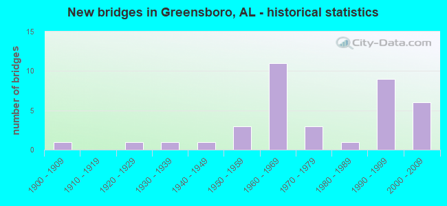
- New bridges - historical statistics
- 11900-1909
- 11920-1929
- 11930-1939
- 11940-1949
- 31950-1959
- 111960-1969
- 31970-1979
- 11980-1989
- 91990-1999
- 62000-2009

- Reconstructed bridges - Historical Statistics
- 11920-1929
- 01930-1939
- 01940-1949
- 01950-1959
- 01960-1969
- 01970-1979
- 11980-1989
- 21990-1999


- Bridge Condition - Deck
- 23.8%Very good
- 23.8%Good
- 42.9%Satisfactory
- 9.5%Fair

- Bridge Condition - Superstructure
- 4.8%Excellent
- 14.3%Very good
- 33.3%Good
- 38.1%Satisfactory
- 9.5%Fair

- Bridge Condition - Substructure
- 4.8%Excellent
- 9.5%Very good
- 33.3%Good
- 42.9%Satisfactory
- 4.8%Fair
- 4.8%Poor

- Bridge Condition - Channel
- 18.9%Very good
- 43.2%Good
- 27.0%Satisfactory
- 10.8%Fair

- Bridge Condition - Culverts
- 12.5%Very good
- 62.5%Good
- 25.0%Satisfactory
Find on map >> Show street view
Structure Number: 251, Location: 3.1 MI.S. GREENSBORO (Lat: 32.661667, Lng: -87.545000), Route carried "on" structure: County highway , Year Built: 1900, Year Reconstructed: 1925, Status: Open, Structure Length: 0.85m (2.79ft), Average Daily Traffic: 100 (year 1991), Average Future Daily Traffic: 300 (year 2033), Design Load: H 15, Features Intersected: TRIB. TO WHITSITT CREEK, Facility Carried by Structure: HORSESHOE BEND RD
Minimum Vertical Clearance: 30+ m (98+ ft), Kilometerpoint: 0.010, Lanes on structure: 2, Owner: County Highway Agency, Approaching Roadway Width: 8.5m (27.9ft), Skew: 4 degrees, Material/Design: Concrete, Design/Construction: Culvert, Number Of Spans In Main Unit: 2, Length of Maximum Span: 4.3m (14.1ft)
Condition: Channel: Satisfactory, Culverts: Satisfactory, Operating Rating: 43.1 metric tons, Method Used To Determine Operating Rating: Load Factor (LF), Inventory Rating: 32.7 metric tons, Method Used To Determine Inventory Rating: Load Factor (LF), Structural Evaluation: Equal to present minimum criteria, Waterway Adequacy: Equal to present minimum criteria, Approach Roadway Alignment: Better than present minimum criteria, Length Of Structure Improvement: 1.51m (4.95ft), Designated Inspection Frequency: Every 24 months, Inspection Date: May 2021, Bridge Improvement Cost: $306,000, Roadway Improvement Cost: $31,000, Total Project Cost: $337,000 ( Estimate for 2022)
Find on map >> Show street view
Structure Number: 1733, Location: 1.5 MI. W. OF GROVEHILL (Lat: 31.705253, Lng: -87.809622), Route carried "on" structure: County highway , Year Built: 1938, Status: Open, Structure Length: 0.67m (2.20ft), Average Daily Traffic: 1,900 (year 2000), Truck Traffic: 27%, Average Future Daily Traffic: 2,820 (year 2038), Design Load: H 15, Features Intersected: BOB BRANCH, Facility Carried by Structure: ???????
Minimum Vertical Clearance: 30+ m (98+ ft), Kilometerpoint: 66.239, Lanes on structure: 2, Owner: County Highway Agency, Approaching Roadway Width: 8.8m (28.9ft), Material/Design: Concrete, Design/Construction: Culvert, Number Of Spans In Main Unit: 2, Length of Maximum Span: 3.0m (9.8ft)
Condition: Channel: Satisfactory, Culverts: Satisfactory, Operating Rating: 76.1 metric tons, Method Used To Determine Operating Rating: Load Factor (LF), Inventory Rating: 45.6 metric tons, Method Used To Determine Inventory Rating: Load Factor (LF), Structural Evaluation: Equal to present minimum criteria, Waterway Adequacy: Equal to present desirable criteria, Approach Roadway Alignment: Better than present minimum criteria, Length Of Structure Improvement: 1.30m (4.27ft), Designated Inspection Frequency: Every 24 months, Inspection Date: November 2021, Bridge Improvement Cost: $488,000, Roadway Improvement Cost: $49,000, Total Project Cost: $537,000 ( Estimate for 2022), Deck Structure Type: Concrete Cast-file-Place, Wearing Surface/Protective System: Wearing Surface: Bituminous
Find on map >> Show street view
Structure Number: 3232, Location: 3.5 MI S JCT AL 69 (Lat: 32.636917, Lng: -87.604167), Route carried "on" structure: State highway 25, Year Built: 1948, Status: Open, Structure Length: 2.56m (8.40ft), Average Daily Traffic: 1,634 (year 2020), Truck Traffic: 17%, Average Future Daily Traffic: 2,201 (year 2038), Design Load: H 15, Features Intersected: LITTLE PRAIRIE CREEK
Minimum Vertical Clearance: 30+ m (98+ ft), Kilometerpoint: 77.286, Lanes on structure: 2, Owner: State Highway Agency, Approaching Roadway Width: 9.8m (32.2ft), Material/Design: Concrete, Design/Construction: Tee Beam, Number Of Spans In Main Unit: 3, Length of Maximum Span: 9.1m (29.9ft), Curb or Sidewalk Widths: Left: 0.5m (1.6ft), Right: 0.5m (1.6ft), Curb-To-Curb Width: 7.3m (24.0ft), Out-to-Out Width: 8.9m (29.2ft)
Condition: Deck: Satisfactory, Superstructure: Good, Substructure: Satisfactory, Channel: Satisfactory, Operating Rating: 46.6 metric tons, Method Used To Determine Operating Rating: Load Factor (LF), Inventory Rating: 28.0 metric tons, Method Used To Determine Inventory Rating: Load Factor (LF), Structural Evaluation: Equal to present minimum criteria, Deck Geometry: Meets minimum limits, Waterway Adequacy: Equal to present minimum criteria, Approach Roadway Alignment: Better than present minimum criteria, Length Of Structure Improvement: 3.46m (11.35ft), Designated Inspection Frequency: Every 24 months, Inspection Date: October 2020, Bridge Improvement Cost: $687,000, Roadway Improvement Cost: $69,000, Total Project Cost: $756,000 ( Estimate for 2022), Deck Structure Type: Concrete Cast-file-Place, Wearing Surface/Protective System: Wearing Surface: Bituminous
Find on map >> Show street view
Structure Number: 3576, Location: 2 MI. S. GREENSBORO (Lat: 32.670086, Lng: -87.589617), Route carried "on" structure: County highway , Year Built: 1950, Status: Posted for load, Structure Length: 1.19m (3.90ft), Average Daily Traffic: 50 (year 1989), Average Future Daily Traffic: 150 (year 2033), Design Load: H 10, Features Intersected: PICKS CREEK, Facility Carried by Structure: GROSS RD
Minimum Vertical Clearance: 30+ m (98+ ft), Kilometerpoint: 0.010, Lanes on structure: 1, Owner: County Highway Agency, Approaching Roadway Width: 4.9m (16.1ft), Material/Design: Wood or Timber, Design/Construction: Stringer/Multi-beam, Number Of Spans In Main Unit: 3, Length of Maximum Span: 4.3m (14.1ft), Curb-To-Curb Width: 4.9m (16.1ft), Out-to-Out Width: 4.9m (16.1ft)
Condition: Deck: Fair, Superstructure: Fair, Substructure: Poor, Channel: Fair, Operating Rating: 8.6 metric tons, Method Used To Determine Operating Rating: Allowable Stress (AS), Inventory Rating: 6.4 metric tons, Method Used To Determine Inventory Rating: Allowable Stress (AS), Structural Evaluation: High priority of replacement, Deck Geometry: High priority of corrective action, Waterway Adequacy: Somewhat better than minimum adequacy, Approach Roadway Alignment: Equal to present minimum criteria, Bridge Posting: Required (Relationship of Operating Rating to Maximum Legal Load: > 39.9% below), Length Of Structure Improvement: 1.86m (6.10ft), Designated Inspection Frequency: Every 24 months, Other Special Inspection Frequency: Every 12 months, Inspection Date: April 2021, Other Special Inspection Date: April 2021, Bridge Improvement Cost: $204,000, Roadway Improvement Cost: $20,000, Total Project Cost: $224,000 ( Estimate for 2022), Deck Structure Type: Wood or Timber, Wearing Surface/Protective System: Wearing Surface: Wood or Timber
Find on map >> Show street view
Structure Number: 5572, Location: 0.2 MI. N.SR.123 (Lat: 31.595272, Lng: -85.783100), Route carried "on" structure: US 231, Year Built: 1956, Status: Open, Structure Length: 12.44m (40.81ft), Average Daily Traffic: 7,235 (year 2013), Truck Traffic: 22%, Average Future Daily Traffic: 9,404 (year 2033), Design Load: HS 20, Features Intersected: PEA RIVER RELIEF
Minimum Vertical Clearance: 30+ m (98+ ft), Kilometerpoint: 90.334, Lanes on structure: 2, Base Highway Network: Yes, Owner: State Highway Agency, Approaching Roadway Width: 12.2m (40.0ft), Skew: 10 degrees, Material/Design: Concrete, Design/Construction: Tee Beam, Number Of Spans In Main Unit: 12, Length of Maximum Span: 10.4m (34.1ft), Curb or Sidewalk Widths: Left: 0.5m (1.6ft), Right: 0.5m (1.6ft), Curb-To-Curb Width: 8.5m (27.9ft), Out-to-Out Width: 10.1m (33.1ft)
Condition: Deck: Satisfactory, Superstructure: Satisfactory, Substructure: Good, Channel: Very good, Operating Rating: 46.6 metric tons, Method Used To Determine Operating Rating: Load Factor (LF), Inventory Rating: 27.9 metric tons, Method Used To Determine Inventory Rating: Load Factor (LF), Structural Evaluation: Equal to present minimum criteria, Deck Geometry: High priority of corrective action, Waterway Adequacy: Equal to present desirable criteria, Approach Roadway Alignment: Equal to present desirable criteria, Length Of Structure Improvement: 13.28m (43.57ft), Designated Inspection Frequency: Every 24 months, Inspection Date: June 2020, Bridge Improvement Cost: $3,004,000, Roadway Improvement Cost: $300,000, Total Project Cost: $3,304,000 ( Estimate for 2022), Deck Structure Type: Concrete Cast-file-Place
Find on map >> Show street view
Structure Number: 7644, Location: 5 MI. E. OF GREENSBORO (Lat: 32.717439, Lng: -87.522586), Route carried "on" structure: County highway , Year Built: 1962, Status: Posted for load, Structure Length: 5.18m (16.99ft), Average Daily Traffic: 200 (year 1989), Truck Traffic: 1%, Average Future Daily Traffic: 400 (year 2034), Design Load: H 15, Features Intersected: POLE CAT CREEK, Facility Carried by Structure: COUNTY ROAD 7
Minimum Vertical Clearance: 30+ m (98+ ft), Kilometerpoint: 0.010, Lanes on structure: 2, Owner: County Highway Agency, Approaching Roadway Width: 8.5m (27.9ft), Material/Design: Concrete, Design/Construction: Tee Beam, Number Of Spans In Main Unit: 5, Length of Maximum Span: 10.4m (34.1ft), Curb-To-Curb Width: 6.7m (22.0ft), Out-to-Out Width: 7.2m (23.6ft)
Condition: Deck: Satisfactory, Superstructure: Good, Substructure: Good, Channel: Fair, Operating Rating: 38.8 metric tons, Method Used To Determine Operating Rating: Allowable Stress (AS), Inventory Rating: 23.5 metric tons, Method Used To Determine Inventory Rating: Allowable Stress (AS), Structural Evaluation: Equal to present minimum criteria, Deck Geometry: Meets minimum limits, Waterway Adequacy: Better than present minimum criteria, Approach Roadway Alignment: Somewhat better than minimum adequacy, Bridge Posting: Required (Relationship of Operating Rating to Maximum Legal Load: 10.0 - 19.9% below), Length Of Structure Improvement: 6.20m (20.34ft), Designated Inspection Frequency: Every 24 months, Other Special Inspection Frequency: Every 12 months, Inspection Date: November 2020, Other Special Inspection Date: November 2021, Bridge Improvement Cost: $978,000, Roadway Improvement Cost: $98,000, Total Project Cost: $1,076,000 ( Estimate for 2022), Deck Structure Type: Concrete Cast-file-Place
Find on map >> Show street view
Structure Number: 8631, Location: 4.7 MI. W. OF GREENSBORO (Lat: 32.685000, Lng: -87.663333), Route carried "on" structure: County highway , Year Built: 1965, Status: Open, Structure Length: 0.64m (2.10ft), Average Daily Traffic: 100 (year 1989), Average Future Daily Traffic: 300 (year 2033), Design Load: H 15, Features Intersected: TRIB. TO BIG GERMAN CRK, Facility Carried by Structure: AIRPORT LOOP ROAD
Minimum Vertical Clearance: 30+ m (98+ ft), Kilometerpoint: 0.010, Lanes on structure: 2, Owner: County Highway Agency, Approaching Roadway Width: 8.5m (27.9ft), Material/Design: Concrete, Design/Construction: Culvert, Number Of Spans In Main Unit: 2, Length of Maximum Span: 3.0m (9.8ft)
Condition: Channel: Satisfactory, Culverts: Good, Operating Rating: 88.9 metric tons, Method Used To Determine Operating Rating: Load Factor (LF), Inventory Rating: 54.4 metric tons, Method Used To Determine Inventory Rating: Load Factor (LF), Structural Evaluation: Better than present minimum criteria, Waterway Adequacy: Better than present minimum criteria, Approach Roadway Alignment: Somewhat better than minimum adequacy, Length Of Structure Improvement: 1.26m (4.13ft), Designated Inspection Frequency: Every 24 months, Inspection Date: June 2021, Bridge Improvement Cost: $277,000, Roadway Improvement Cost: $28,000, Total Project Cost: $305,000 ( Estimate for 2022)
Find on map >> Show street view
Structure Number: 8677, Location: 0.6 MI E OF MERIWETHER RD (Lat: 32.266394, Lng: -86.165203), Route carried "on" structure: US 82, Year Built: 1965, Status: Open, Structure Length: 5.18m (16.99ft), Average Daily Traffic: 7,825 (year 2013), Truck Traffic: 20%, Average Future Daily Traffic: 10,131 (year 2033), Design Load: HS 20, Features Intersected: RELIEF
Minimum Vertical Clearance: 30+ m (98+ ft), Kilometerpoint: 265.352, Lanes on structure: 2, Owner: State Highway Agency, Approaching Roadway Width: 12.2m (40.0ft), Skew: 10 degrees, Material/Design: Concrete, Design/Construction: Tee Beam, Number Of Spans In Main Unit: 5, Length of Maximum Span: 10.4m (34.1ft), Curb-To-Curb Width: 8.5m (27.9ft), Out-to-Out Width: 9.4m (30.8ft)
Condition: Deck: Satisfactory, Superstructure: Satisfactory, Substructure: Satisfactory, Channel: Good, Operating Rating: 42.1 metric tons, Method Used To Determine Operating Rating: Load Factor (LF), Inventory Rating: 25.3 metric tons, Method Used To Determine Inventory Rating: Load Factor (LF), Structural Evaluation: Equal to present minimum criteria, Deck Geometry: High priority of corrective action, Waterway Adequacy: Superior to present desirable criteria, Approach Roadway Alignment: Better than present minimum criteria, Length Of Structure Improvement: 6.20m (20.34ft), Designated Inspection Frequency: Every 24 months, Inspection Date: September 2021, Bridge Improvement Cost: $1,276,000, Roadway Improvement Cost: $128,000, Total Project Cost: $1,404,000 ( Estimate for 2022), Deck Structure Type: Concrete Cast-file-Place
Find on map >> Show street view
Structure Number: 8678, Location: 0.8 MI E OF MERIWETHER RD (Lat: 32.264892, Lng: -86.163375), Route carried "on" structure: US 82, Year Built: 1965, Status: Open, Structure Length: 7.25m (23.79ft), Average Daily Traffic: 7,825 (year 2013), Truck Traffic: 20%, Average Future Daily Traffic: 10,131 (year 2033), Design Load: HS 20, Features Intersected: LITTLE CATOMA CREEK
Minimum Vertical Clearance: 30+ m (98+ ft), Kilometerpoint: 265.593, Lanes on structure: 2, Owner: State Highway Agency, Approaching Roadway Width: 12.2m (40.0ft), Skew: 13 degrees, Material/Design: Concrete, Design/Construction: Tee Beam, Number Of Spans In Main Unit: 7, Length of Maximum Span: 10.4m (34.1ft), Curb-To-Curb Width: 8.5m (27.9ft), Out-to-Out Width: 9.4m (30.8ft)
Condition: Deck: Satisfactory, Superstructure: Good, Substructure: Satisfactory, Channel: Good, Operating Rating: 42.1 metric tons, Method Used To Determine Operating Rating: Load Factor (LF), Inventory Rating: 25.3 metric tons, Method Used To Determine Inventory Rating: Load Factor (LF), Structural Evaluation: Equal to present minimum criteria, Deck Geometry: High priority of corrective action, Waterway Adequacy: Superior to present desirable criteria, Approach Roadway Alignment: Better than present minimum criteria, Length Of Structure Improvement: 8.28m (27.17ft), Designated Inspection Frequency: Every 24 months, Inspection Date: November 2021, Bridge Improvement Cost: $1,703,000, Roadway Improvement Cost: $170,000, Total Project Cost: $1,873,000 ( Estimate for 2022), Deck Structure Type: Concrete Cast-file-Place
Find on map >> Show street view
Structure Number: 9092, Location: 1.4 MI. E. OF GREENSBORO (Lat: 32.715000, Lng: -87.558333), Route carried "on" structure: County highway 33, Year Built: 1966, Status: Open, Structure Length: 0.64m (2.10ft), Average Daily Traffic: 100 (year 1989), Average Future Daily Traffic: 300 (year 2033), Design Load: H 15, Features Intersected: TRIB. TO PICKS CREEK
Minimum Vertical Clearance: 30+ m (98+ ft), Kilometerpoint: 0.010, Lanes on structure: 2, Owner: County Highway Agency, Approaching Roadway Width: 8.5m (27.9ft), Material/Design: Concrete, Design/Construction: Culvert, Number Of Spans In Main Unit: 2, Length of Maximum Span: 3.4m (11.2ft)
Condition: Channel: Satisfactory, Culverts: Good, Operating Rating: 40.9 metric tons, Method Used To Determine Operating Rating: Load Factor (LF), Inventory Rating: 24.6 metric tons, Method Used To Determine Inventory Rating: Load Factor (LF), Structural Evaluation: Equal to present minimum criteria, Waterway Adequacy: Equal to present minimum criteria, Approach Roadway Alignment: Equal to present desirable criteria, Length Of Structure Improvement: 1.26m (4.13ft), Designated Inspection Frequency: Every 24 months, Inspection Date: March 2021, Bridge Improvement Cost: $262,000, Roadway Improvement Cost: $26,000, Total Project Cost: $288,000 ( Estimate for 2022)
Find on map >> Show street view
Structure Number: 9339, Location: 3.0 MI. N. OF GREENSBORO (Lat: 32.738333, Lng: -87.616667), Route carried "on" structure: County highway 19, Year Built: 1967, Status: Open, Structure Length: 0.64m (2.10ft), Average Daily Traffic: 100 (year 1989), Average Future Daily Traffic: 350 (year 2034), Design Load: H 15, Features Intersected: TRIB. TO COLWELL CREEK
Minimum Vertical Clearance: 30+ m (98+ ft), Kilometerpoint: 0.010, Lanes on structure: 2, Owner: County Highway Agency, Approaching Roadway Width: 8.5m (27.9ft), Material/Design: Concrete, Design/Construction: Culvert, Number Of Spans In Main Unit: 2, Length of Maximum Span: 3.4m (11.2ft)
Condition: Channel: Good, Culverts: Good, Operating Rating: 88.9 metric tons, Method Used To Determine Operating Rating: Load Factor (LF), Inventory Rating: 58.0 metric tons, Method Used To Determine Inventory Rating: Load Factor (LF), Structural Evaluation: Better than present minimum criteria, Waterway Adequacy: Better than present minimum criteria, Approach Roadway Alignment: Better than present minimum criteria, Length Of Structure Improvement: 1.26m (4.13ft), Designated Inspection Frequency: Every 24 months, Inspection Date: December 2020, Bridge Improvement Cost: $262,000, Roadway Improvement Cost: $26,000, Total Project Cost: $288,000 ( Estimate for 2022)
Find on map >> Show street view
Structure Number: 10053, Location: 4.5 MI. N OF GREENSBORO (Lat: 32.743225, Lng: -87.551397), Route carried "on" structure: County highway , Year Built: 1969, Status: Open, Structure Length: 4.15m (13.62ft), Average Daily Traffic: 150 (year 1989), Truck Traffic: 1%, Average Future Daily Traffic: 300 (year 2034), Design Load: H 15, Features Intersected: POLECAT CREEK, Facility Carried by Structure: COUNTY RT 51
Minimum Vertical Clearance: 30+ m (98+ ft), Kilometerpoint: 0.010, Lanes on structure: 2, Owner: County Highway Agency, Approaching Roadway Width: 8.5m (27.9ft), Material/Design: Concrete, Design/Construction: Channel Beam, Number Of Spans In Main Unit: 5, Length of Maximum Span: 10.4m (34.1ft), Curb-To-Curb Width: 7.4m (24.3ft), Out-to-Out Width: 8.0m (26.2ft)
Condition: Deck: Good, Superstructure: Satisfactory, Substructure: Good, Channel: Fair, Operating Rating: 43.7 metric tons, Method Used To Determine Operating Rating: Allowable Stress (AS), Inventory Rating: 27.2 metric tons, Method Used To Determine Inventory Rating: Allowable Stress (AS), Structural Evaluation: Equal to present minimum criteria, Deck Geometry: Somewhat better than minimum adequacy, Waterway Adequacy: Better than present minimum criteria, Approach Roadway Alignment: Equal to present minimum criteria, Length Of Structure Improvement: 5.12m (16.80ft), Designated Inspection Frequency: Every 24 months, Inspection Date: November 2020, Bridge Improvement Cost: $912,000, Roadway Improvement Cost: $91,000, Total Project Cost: $1,003,000 ( Estimate for 2022), Deck Structure Type: Concrete Precast Panels
Find on map >> Show street view
Structure Number: 10064, Location: 0.5 MI N OF GREENSBORO (Lat: 32.720883, Lng: -87.592850), Route carried "on" structure: State highway 69, Year Built: 1969, Status: Open, Structure Length: 1.01m (3.31ft), Average Daily Traffic: 5,240 (year 2016), Truck Traffic: 11%, Average Future Daily Traffic: 6,811 (year 2041), Design Load: H 15, Features Intersected: CALDWELL CREEK
Minimum Vertical Clearance: 30+ m (98+ ft), Kilometerpoint: 176.344, Lanes on structure: 2, Base Highway Network: Yes, Owner: State Highway Agency, Approaching Roadway Width: 12.2m (40.0ft), Skew: 1 degrees, Material/Design: Concrete, Design/Construction: Culvert, Number Of Spans In Main Unit: 3, Length of Maximum Span: 3.2m (10.5ft)
Condition: Channel: Satisfactory, Culverts: Satisfactory, Operating Rating: 88.9 metric tons, Method Used To Determine Operating Rating: Load Factor (LF), Inventory Rating: 88.9 metric tons, Method Used To Determine Inventory Rating: Load Factor (LF), Structural Evaluation: Equal to present minimum criteria, Waterway Adequacy: Equal to present minimum criteria, Approach Roadway Alignment: Better than present minimum criteria, Length Of Structure Improvement: 1.68m (5.51ft), Designated Inspection Frequency: Every 24 months, Inspection Date: December 2021, Bridge Improvement Cost: $571,000, Roadway Improvement Cost: $57,000, Total Project Cost: $628,000 ( Estimate for 2022)
Find on map >> Show street view
Structure Number: 10065, Location: 3.5 MI N GREENSBORO (Lat: 32.760017, Lng: -87.585283), Route carried "on" structure: State highway 69, Year Built: 1969, Status: Open, Structure Length: 6.22m (20.41ft), Average Daily Traffic: 4,050 (year 2016), Truck Traffic: 14%, Average Future Daily Traffic: 5,265 (year 2040), Design Load: HS 20, Features Intersected: BIG BRUSH CREEK
Minimum Vertical Clearance: 30+ m (98+ ft), Kilometerpoint: 180.823, Lanes on structure: 2, Base Highway Network: Yes, Owner: State Highway Agency, Approaching Roadway Width: 13.4m (44.0ft), Material/Design: Concrete, Design/Construction: Tee Beam, Number Of Spans In Main Unit: 6, Length of Maximum Span: 10.4m (34.1ft), Curb or Sidewalk Widths: Left: 0.2m (0.7ft), Right: 0.2m (0.7ft), Curb-To-Curb Width: 13.4m (44.0ft), Out-to-Out Width: 14.6m (47.9ft)
Condition: Deck: Satisfactory, Superstructure: Satisfactory, Substructure: Satisfactory, Channel: Satisfactory, Operating Rating: 44.5 metric tons, Method Used To Determine Operating Rating: Load Factor (LF), Inventory Rating: 26.7 metric tons, Method Used To Determine Inventory Rating: Load Factor (LF), Structural Evaluation: Equal to present minimum criteria, Deck Geometry: Better than present minimum criteria, Waterway Adequacy: Equal to present minimum criteria, Approach Roadway Alignment: Equal to present desirable criteria, Length Of Structure Improvement: 7.26m (23.82ft), Designated Inspection Frequency: Every 24 months, Inspection Date: December 2020, Bridge Improvement Cost: $2,339,000, Roadway Improvement Cost: $234,000, Total Project Cost: $2,573,000 ( Estimate for 2022), Deck Structure Type: Concrete Cast-file-Place
Find on map >> Show street view
Structure Number: 10066, Location: 3.2 MI N GREENSBORO (Lat: 32.762850, Lng: -87.585317), Route carried "on" structure: State highway 69, Year Built: 1969, Status: Open, Structure Length: 15.54m (50.98ft), Average Daily Traffic: 4,050 (year 2016), Truck Traffic: 14%, Average Future Daily Traffic: 5,265 (year 2040), Design Load: HS 20, Features Intersected: BIG BRUSH CREEK RELIEF
Minimum Vertical Clearance: 30+ m (98+ ft), Kilometerpoint: 181.138, Lanes on structure: 2, Base Highway Network: Yes, Owner: State Highway Agency, Approaching Roadway Width: 13.4m (44.0ft), Material/Design: Concrete, Design/Construction: Tee Beam, Number Of Spans In Main Unit: 15, Length of Maximum Span: 10.4m (34.1ft), Curb or Sidewalk Widths: Left: 0.2m (0.7ft), Right: 0.2m (0.7ft), Curb-To-Curb Width: 13.4m (44.0ft), Out-to-Out Width: 14.3m (46.9ft)
Condition: Deck: Satisfactory, Superstructure: Satisfactory, Substructure: Good, Channel: Good, Operating Rating: 44.5 metric tons, Method Used To Determine Operating Rating: Load Factor (LF), Inventory Rating: 26.7 metric tons, Method Used To Determine Inventory Rating: Load Factor (LF), Structural Evaluation: Equal to present minimum criteria, Deck Geometry: Better than present minimum criteria, Waterway Adequacy: Equal to present minimum criteria, Approach Roadway Alignment: Equal to present desirable criteria, Length Of Structure Improvement: 16.31m (53.51ft), Designated Inspection Frequency: Every 24 months, Inspection Date: December 2020, Bridge Improvement Cost: $5,255,000, Roadway Improvement Cost: $526,000, Total Project Cost: $5,781,000 ( Estimate for 2022), Deck Structure Type: Concrete Cast-file-Place
Find on map >> Show street view
Structure Number: 1201, Location: 5.9 MI. E. OF MILLWOOD (Lat: 32.693333, Lng: -87.661667), Route carried "on" structure: County highway 24, Year Built: 1978, Status: Open, Structure Length: 0.64m (2.10ft), Average Daily Traffic: 200 (year 1989), Truck Traffic: 1%, Average Future Daily Traffic: 400 (year 2033), Design Load: H 15, Features Intersected: BIG GERMAN CREEK TRIB.
Minimum Vertical Clearance: 30+ m (98+ ft), Kilometerpoint: 0.010, Lanes on structure: 2, Owner: County Highway Agency, Approaching Roadway Width: 8.5m (27.9ft), Material/Design: Concrete, Design/Construction: Culvert, Number Of Spans In Main Unit: 2, Length of Maximum Span: 2.1m (6.9ft)
Condition: Channel: Fair, Culverts: Good, Operating Rating: 88.9 metric tons, Method Used To Determine Operating Rating: Load Factor (LF), Inventory Rating: 88.9 metric tons, Method Used To Determine Inventory Rating: Load Factor (LF), Structural Evaluation: Better than present minimum criteria, Waterway Adequacy: Better than present minimum criteria, Approach Roadway Alignment: Equal to present minimum criteria, Length Of Structure Improvement: 1.26m (4.13ft), Designated Inspection Frequency: Every 24 months, Inspection Date: June 2021, Bridge Improvement Cost: $211,000, Roadway Improvement Cost: $21,000, Total Project Cost: $232,000 ( Estimate for 2022)
Find on map >> Show street view
Structure Number: 12011, Location: 3.1 MI. W OF GREENSBORO (Lat: 32.693333, Lng: -87.653333), Route carried "on" structure: County highway 24, Year Built: 1978, Status: Open, Structure Length: 0.64m (2.10ft), Average Daily Traffic: 200 (year 1989), Truck Traffic: 1%, Average Future Daily Traffic: 400 (year 2033), Design Load: H 15, Features Intersected: BIG GERMAN CREEK
Minimum Vertical Clearance: 30+ m (98+ ft), Kilometerpoint: 0.010, Lanes on structure: 2, Owner: County Highway Agency, Approaching Roadway Width: 8.5m (27.9ft), Material/Design: Concrete, Design/Construction: Culvert, Number Of Spans In Main Unit: 2, Length of Maximum Span: 3.0m (9.8ft)
Condition: Channel: Good, Culverts: Good, Operating Rating: 88.9 metric tons, Method Used To Determine Operating Rating: Load Factor (LF), Inventory Rating: 78.0 metric tons, Method Used To Determine Inventory Rating: Load Factor (LF), Structural Evaluation: Better than present minimum criteria, Waterway Adequacy: Better than present minimum criteria, Approach Roadway Alignment: Equal to present minimum criteria, Length Of Structure Improvement: 1.26m (4.13ft), Designated Inspection Frequency: Every 24 months, Inspection Date: June 2021, Bridge Improvement Cost: $277,000, Roadway Improvement Cost: $28,000, Total Project Cost: $305,000 ( Estimate for 2022)
Find on map >> Show street view
Structure Number: 13293, Location: 1.3 MI. N. OF GREENSBORO (Lat: 32.729172, Lng: -87.597050), Route carried "on" structure: County highway , Year Built: 1984, Status: Open, Structure Length: 0.67m (2.20ft), Average Daily Traffic: 400 (year 1989), Truck Traffic: 1%, Average Future Daily Traffic: 400 (year 2034), Design Load: H 10, Features Intersected: COLWELL CREEK TRIB., Facility Carried by Structure: COUNTY ROAD 19
Minimum Vertical Clearance: 30+ m (98+ ft), Kilometerpoint: 0.010, Lanes on structure: 2, Owner: County Highway Agency, Approaching Roadway Width: 8.5m (27.9ft), Material/Design: Concrete, Design/Construction: Culvert, Number Of Spans In Main Unit: 2, Length of Maximum Span: 3.7m (12.1ft), Curb-To-Curb Width: 11.6m (38.1ft), Out-to-Out Width: 11.9m (39.0ft)
Condition: Channel: Good, Culverts: Good, Operating Rating: 88.9 metric tons, Method Used To Determine Operating Rating: Load Factor (LF), Inventory Rating: 63.1 metric tons, Method Used To Determine Inventory Rating: Load Factor (LF), Structural Evaluation: Better than present minimum criteria, Deck Geometry: Superior to present desirable criteria, Waterway Adequacy: Better than present minimum criteria, Approach Roadway Alignment: Equal to present minimum criteria, Length Of Structure Improvement: 1.30m (4.27ft), Designated Inspection Frequency: Every 24 months, Inspection Date: December 2020, Bridge Improvement Cost: $330,000, Roadway Improvement Cost: $33,000, Total Project Cost: $363,000 ( Estimate for 2022)
Find on map >> Show street view
Structure Number: 13734, Location: 0.4 MI E JCT SR 61 (Lat: 32.699650, Lng: -87.572117), Route carried "on" structure: State highway 14, Year Built: 1929, Year Reconstructed: 1986, Status: Open, Structure Length: 0.64m (2.10ft), Average Daily Traffic: 7,220 (year 2016), Truck Traffic: 8%, Average Future Daily Traffic: 9,724 (year 2040), Design Load: H 15, Features Intersected: Colwell Creek
Minimum Vertical Clearance: 30+ m (98+ ft), Kilometerpoint: 111.531, Lanes on structure: 2, Base Highway Network: Yes, Owner: State Highway Agency, Approaching Roadway Width: 9.1m (29.9ft), Material/Design: Concrete, Design/Construction: Culvert, Number Of Spans In Main Unit: 2, Length of Maximum Span: 3.0m (9.8ft)
Condition: Channel: Good, Culverts: Satisfactory, Operating Rating: 70.1 metric tons, Method Used To Determine Operating Rating: Load Factor (LF), Inventory Rating: 42.1 metric tons, Method Used To Determine Inventory Rating: Load Factor (LF), Structural Evaluation: Equal to present minimum criteria, Waterway Adequacy: Equal to present minimum criteria, Approach Roadway Alignment: Better than present minimum criteria, Length Of Structure Improvement: 1.26m (4.13ft), Designated Inspection Frequency: Every 24 months, Inspection Date: September 2020, Bridge Improvement Cost: $306,000, Roadway Improvement Cost: $31,000, Total Project Cost: $337,000 ( Estimate for 2022)
Find on map >> Show street view
Structure Number: 16121, Location: 4.3 MI. W. OF GREENSBORO (Lat: 32.705000, Lng: -87.631667), Route carried "on" structure: County highway , Year Built: 1994, Status: Open, Structure Length: 0.64m (2.10ft), Average Daily Traffic: 200 (year 1989), Truck Traffic: 1%, Average Future Daily Traffic: 400 (year 2033), Design Load: H 15, Features Intersected: BIG GERMAN CREEK TRIB., Facility Carried by Structure: COUNTY ROAD #28
Minimum Vertical Clearance: 30+ m (98+ ft), Kilometerpoint: 0.010, Lanes on structure: 2, Owner: County Highway Agency, Approaching Roadway Width: 8.5m (27.9ft), Material/Design: Concrete, Design/Construction: Culvert, Number Of Spans In Main Unit: 2, Length of Maximum Span: 3.0m (9.8ft), Curb-To-Curb Width: 13.1m (43.0ft), Out-to-Out Width: 13.6m (44.6ft)
Condition: Channel: Good, Culverts: Good, Operating Rating: 88.9 metric tons, Method Used To Determine Operating Rating: Load Factor (LF), Inventory Rating: 88.9 metric tons, Method Used To Determine Inventory Rating: Load Factor (LF), Structural Evaluation: Better than present minimum criteria, Deck Geometry: Superior to present desirable criteria, Waterway Adequacy: Better than present minimum criteria, Approach Roadway Alignment: Equal to present minimum criteria, Length Of Structure Improvement: 1.26m (4.13ft), Designated Inspection Frequency: Every 24 months, Inspection Date: March 2021, Bridge Improvement Cost: $320,000, Roadway Improvement Cost: $32,000, Total Project Cost: $352,000 ( Estimate for 2022), Deck Structure Type: Concrete Cast-file-Place, Wearing Surface/Protective System: Wearing Surface: Bituminous
Find on map >> Show street view
Structure Number: 16382, Location: GREENSBORO (Lat: 32.714000, Lng: -87.588892), Route carried "on" structure: State highway 25, Year Built: 1995, Status: Open, Structure Length: 1.13m (3.71ft), Average Daily Traffic: 2,290 (year 2013), Truck Traffic: 7%, Average Future Daily Traffic: 3,036 (year 2040), Design Load: HS 20, Features Intersected: COLWELL CREEK
Minimum Vertical Clearance: 30+ m (98+ ft), Kilometerpoint: 87.379, Lanes on structure: 2, Base Highway Network: Yes, Owner: State Highway Agency, Approaching Roadway Width: 13.1m (43.0ft), Material/Design: Concrete, Design/Construction: Culvert, Number Of Spans In Main Unit: 3, Length of Maximum Span: 3.7m (12.1ft), Curb-To-Curb Width: 12.3m (40.4ft), Out-to-Out Width: 13.1m (43.0ft)
Condition: Channel: Satisfactory, Culverts: Good, Operating Rating: 88.9 metric tons, Method Used To Determine Operating Rating: Load Factor (LF), Inventory Rating: 68.2 metric tons, Method Used To Determine Inventory Rating: Load Factor (LF), Structural Evaluation: Better than present minimum criteria, Deck Geometry: Equal to present minimum criteria, Waterway Adequacy: Equal to present minimum criteria, Approach Roadway Alignment: Equal to present minimum criteria, Length Of Structure Improvement: 1.81m (5.94ft), Designated Inspection Frequency: Every 24 months, Inspection Date: October 2020, Bridge Improvement Cost: $448,000, Roadway Improvement Cost: $45,000, Total Project Cost: $493,000 ( Estimate for 2022)
Find on map >> Show street view
Structure Number: 16487, Location: 4.0 MI N GREENSBORO (Lat: 32.750853, Lng: -87.556522), Route carried "on" structure: State highway 25, Year Built: 1996, Status: Open, Structure Length: 14.94m (49.02ft), Average Daily Traffic: 1,104 (year 2019), Truck Traffic: 5%, Average Future Daily Traffic: 1,809 (year 2039), Design Load: HS 20, Features Intersected: BIG BRUSH CREEK
Minimum Vertical Clearance: 30+ m (98+ ft), Kilometerpoint: 92.819, Lanes on structure: 2, Base Highway Network: Yes, Owner: State Highway Agency, Approaching Roadway Width: 9.4m (30.8ft), Material/Design: Prestressed concrete, Design/Construction: Stringer/Multi-beam, Number Of Spans In Main Unit: 7, Length of Maximum Span: 21.3m (69.9ft), Curb-To-Curb Width: 12.2m (40.0ft), Out-to-Out Width: 13.0m (42.7ft)
Condition: Deck: Very good, Superstructure: Excellent, Substructure: Excellent, Channel: Good, Operating Rating: 75.8 metric tons, Method Used To Determine Operating Rating: Load Factor (LF), Inventory Rating: 52.2 metric tons, Method Used To Determine Inventory Rating: Load Factor (LF), Structural Evaluation: Superior to present desirable criteria, Deck Geometry: Better than present minimum criteria, Waterway Adequacy: Equal to present minimum criteria, Approach Roadway Alignment: Equal to present minimum criteria, Length Of Structure Improvement: 15.72m (51.57ft), Designated Inspection Frequency: Every 24 months, Inspection Date: November 2020, Bridge Improvement Cost: $4,526,000, Roadway Improvement Cost: $453,000, Total Project Cost: $4,979,000 ( Estimate for 2022), Deck Structure Type: Concrete Cast-file-Place
Find on map >> Show street view
Structure Number: 17372, Location: 2.5 MILES S OF WAVERLY (Lat: 32.714472, Lng: -85.542472), Route carried "on" structure: US AL038, Year Built: 2000, Status: Open, Structure Length: 3.29m (10.79ft), Average Daily Traffic: 5,650 (year 2013), Truck Traffic: 12%, Average Future Daily Traffic: 7,432 (year 2033), Design Load: HS 20, Features Intersected: LOBLOCKEE CREEK, Facility Carried by Structure: US 280
Minimum Vertical Clearance: 30+ m (98+ ft), Kilometerpoint: 156.935, Lanes on structure: 2, Base Highway Network: Yes, Owner: State Highway Agency, Approaching Roadway Width: 11.2m (36.7ft), Material/Design: Prestressed concrete, Design/Construction: Stringer/Multi-beam, Number Of Spans In Main Unit: 3, Length of Maximum Span: 11.0m (36.1ft), Curb-To-Curb Width: 12.0m (39.4ft), Out-to-Out Width: 12.8m (42.0ft)
Condition: Deck: Satisfactory, Superstructure: Good, Substructure: Good, Channel: Good, Operating Rating: 75.1 metric tons, Method Used To Determine Operating Rating: Load Factor (LF), Inventory Rating: 45.0 metric tons, Method Used To Determine Inventory Rating: Load Factor (LF), Structural Evaluation: Better than present minimum criteria, Deck Geometry: Better than present minimum criteria, Waterway Adequacy: Superior to present desirable criteria, Approach Roadway Alignment: Better than present minimum criteria, Length Of Structure Improvement: 4.17m (13.68ft), Designated Inspection Frequency: Every 24 months, Inspection Date: November 2020, Bridge Improvement Cost: $1,201,000, Roadway Improvement Cost: $120,000, Total Project Cost: $1,321,000 ( Estimate for 2022), Deck Structure Type: Concrete Cast-file-Place
Find on map >> Show street view
Structure Number: 17373, Location: 1 MI S.E. OF BELLWOOD???? (Lat: 31.162997, Lng: -85.789092), Route carried "on" structure: County highway 45, Year Built: 1998, Status: Open, Structure Length: 13.80m (45.28ft), Average Daily Traffic: 450 (year 2020), Truck Traffic: 5%, Average Future Daily Traffic: 586 (year 2040), Design Load: HS 20, Features Intersected: SPEARS CREEK
Minimum Vertical Clearance: 7.56m (24.80ft), Kilometerpoint: 0.000, Lanes on structure: 2, Owner: County Highway Agency, Approaching Roadway Width: 9.0m (29.5ft), Material/Design: Prestressed concrete, Design/Construction: Stringer/Multi-beam, Number Of Spans In Main Unit: 6, Length of Maximum Span: 23.0m (75.5ft), Curb-To-Curb Width: 9.0m (29.5ft), Out-to-Out Width: 9.8m (32.2ft)
Condition: Deck: Good, Superstructure: Very good, Substructure: Very good, Channel: Very good, Operating Rating: 71.4 metric tons, Method Used To Determine Operating Rating: Load Factor (LF), Inventory Rating: 38.2 metric tons, Method Used To Determine Inventory Rating: Load Factor (LF), Structural Evaluation: Equal to present desirable criteria, Deck Geometry: Somewhat better than minimum adequacy, Waterway Adequacy: Superior to present desirable criteria, Approach Roadway Alignment: Equal to present desirable criteria, Length Of Structure Improvement: 14.60m (47.90ft), Designated Inspection Frequency: Every 24 months, Inspection Date: October 2020, Bridge Improvement Cost: $3,204,000, Roadway Improvement Cost: $320,000, Total Project Cost: $3,524,000 ( Estimate for 2022), Deck Structure Type: Concrete Cast-file-Place
Find on map >> Show street view
Structure Number: 17374, Location: 1 MI S. E. OF BELLWOOD (Lat: 31.159753, Lng: -85.784983), Route carried "on" structure: County highway 45, Year Built: 1998, Status: Open, Structure Length: 32.30m (105.97ft), Average Daily Traffic: 450 (year 2020), Truck Traffic: 5%, Average Future Daily Traffic: 590 (year 2040), Design Load: HS 20, Features Intersected: CHOCTAWHATCHEE RIVER
Minimum Vertical Clearance: 7.56m (24.80ft), Kilometerpoint: 0.000, Lanes on structure: 2, Owner: County Highway Agency, Approaching Roadway Width: 9.0m (29.5ft), Material/Design: Prestressed concrete, Design/Construction: Stringer/Multi-beam, Number Of Spans In Main Unit: 3, Number Of Approach Spans: 10, Length of Maximum Span: 31.0m (101.7ft), Curb-To-Curb Width: 9.0m (29.5ft), Out-to-Out Width: 9.8m (32.2ft)
Condition: Deck: Good, Superstructure: Good, Substructure: Satisfactory, Channel: Good, Operating Rating: 62.8 metric tons, Method Used To Determine Operating Rating: Load Factor (LF), Inventory Rating: 39.2 metric tons, Method Used To Determine Inventory Rating: Load Factor (LF), Structural Evaluation: Equal to present minimum criteria, Deck Geometry: Somewhat better than minimum adequacy, Waterway Adequacy: Superior to present desirable criteria, Approach Roadway Alignment: Superior to present desirable criteria, Length Of Structure Improvement: 32.30m (105.97ft), Designated Inspection Frequency: Every 24 months, Inspection Date: October 2020, Bridge Improvement Cost: $7,087,000, Roadway Improvement Cost: $709,000, Total Project Cost: $7,796,000 ( Estimate for 2022), Deck Structure Type: Concrete Cast-file-Place
Find on map >> Show street view
Structure Number: 17375, Location: 2.8 MILES S OF JACHIN (Lat: 32.187717, Lng: -88.170417), Route carried "on" structure: State highway 17, Year Built: 2000, Status: Open, Structure Length: 3.60m (11.81ft), Average Daily Traffic: 1,160 (year 2013), Truck Traffic: 18%, Average Future Daily Traffic: 1,496 (year 2033), Design Load: HS 20, Features Intersected: TUCKABUM CREEK REL.
Minimum Vertical Clearance: 30+ m (98+ ft), Kilometerpoint: 187.913, Lanes on structure: 2, Owner: State Highway Agency, Approaching Roadway Width: 12.2m (40.0ft), Material/Design: Prestressed concrete continuous, Design/Construction: Stringer/Multi-beam, Number Of Spans In Main Unit: 3, Length of Maximum Span: 12.0m (39.4ft), Curb-To-Curb Width: 12.2m (40.0ft), Out-to-Out Width: 13.0m (42.7ft)
Condition: Deck: Good, Superstructure: Good, Substructure: Good, Channel: Good, Operating Rating: 55.6 metric tons, Method Used To Determine Operating Rating: Load Factor (LF), Inventory Rating: 33.3 metric tons, Method Used To Determine Inventory Rating: Load Factor (LF), Structural Evaluation: Better than present minimum criteria, Deck Geometry: Better than present minimum criteria, Waterway Adequacy: Equal to present desirable criteria, Approach Roadway Alignment: Equal to present desirable criteria, Length Of Structure Improvement: 4.51m (14.80ft), Designated Inspection Frequency: Every 24 months, Inspection Date: October 2020, Bridge Improvement Cost: $1,300,000, Roadway Improvement Cost: $130,000, Total Project Cost: $1,430,000 ( Estimate for 2022), Deck Structure Type: Concrete Cast-file-Place
Find on map >> Show street view
Structure Number: 17377, Location: 0.2 MILES S OF CHATOM (Lat: 31.452733, Lng: -88.260650), Route carried "on" structure: State highway 17, Year Built: 2000, Status: Open, Structure Length: 1.97m (6.46ft), Average Daily Traffic: 1,880 (year 2013), Truck Traffic: 17%, Average Future Daily Traffic: 2,425 (year 2033), Design Load: HS 20, Features Intersected: MILES CREEK
Minimum Vertical Clearance: 30+ m (98+ ft), Kilometerpoint: 94.839, Lanes on structure: 2, Owner: State Highway Agency, Approaching Roadway Width: 12.0m (39.4ft), Material/Design: Concrete, Design/Construction: Culvert, Number Of Spans In Main Unit: 4, Length of Maximum Span: 4.8m (15.7ft)
Condition: Channel: Good, Culverts: Good, Operating Rating: 85.4 metric tons, Method Used To Determine Operating Rating: Load Factor (LF), Inventory Rating: 51.2 metric tons, Method Used To Determine Inventory Rating: Load Factor (LF), Structural Evaluation: Better than present minimum criteria, Waterway Adequacy: Equal to present desirable criteria, Approach Roadway Alignment: Equal to present desirable criteria, Length Of Structure Improvement: 2.71m (8.89ft), Designated Inspection Frequency: Every 24 months, Inspection Date: September 2020, Bridge Improvement Cost: $861,000, Roadway Improvement Cost: $86,000, Total Project Cost: $947,000 ( Estimate for 2022)
Find on map >> Show street view
Structure Number: 1738, Location: SAXONS ARCH)SAXONS X RDS (Lat: 33.407300, Lng: -85.344500), Route carried "on" structure: Alternate County highway 455, Year Built: 1997, Status: Open, Structure Length: 0.71m (2.33ft), Average Daily Traffic: 50 (year 1998), Average Future Daily Traffic: 153 (year 2035), Design Load: HS 20, Features Intersected: COPPER ROCK CREEK
Minimum Vertical Clearance: 7.56m (24.80ft), Kilometerpoint: 0.100, Lanes on structure: 2, Owner: County Highway Agency, Approaching Roadway Width: 6.0m (19.7ft), Material/Design: Aluminum, Iron, Design/Construction: Culvert, Number Of Spans In Main Unit: 1, Length of Maximum Span: 7.1m (23.3ft)
Condition: Channel: Very good, Culverts: Very good, Operating Rating: 56.6 metric tons, Method Used To Determine Operating Rating: Load Factor (LF), Inventory Rating: 33.9 metric tons, Method Used To Determine Inventory Rating: Load Factor (LF), Structural Evaluation: Equal to present desirable criteria, Waterway Adequacy: Equal to present desirable criteria, Approach Roadway Alignment: Equal to present minimum criteria, Length Of Structure Improvement: 1.35m (4.43ft), Designated Inspection Frequency: Every 24 months, Inspection Date: March 2020, Bridge Improvement Cost: $179,000, Roadway Improvement Cost: $18,000, Total Project Cost: $197,000 ( Estimate for 2022)
Find on map >> Show street view
Structure Number: 17383, Location: .25 MI. S. OF CO. RD. 471 (Lat: 33.332300, Lng: -85.377300), Route carried "on" structure: County highway 471, Year Built: 1998, Status: Open, Structure Length: 0.76m (2.49ft), Average Daily Traffic: 50 (year 1998), Average Future Daily Traffic: 85 (year 2030), Design Load: HS 20, Features Intersected: BEAR CREEK, Facility Carried by Structure: CO. RD. 470
Minimum Vertical Clearance: 30+ m (98+ ft), Kilometerpoint: 0.100, Lanes on structure: 1, Owner: County Highway Agency, Approaching Roadway Width: 6.0m (19.7ft), Material/Design: Concrete, Design/Construction: Culvert, Number Of Spans In Main Unit: 3, Length of Maximum Span: 2.2m (7.2ft)
Condition: Channel: Very good, Culverts: Very good, Operating Rating: 43.5 metric tons, Method Used To Determine Operating Rating: Field evaluation and documented engineering judgment, Inventory Rating: 32.7 metric tons, Method Used To Determine Inventory Rating: Field evaluation and documented engineering judgment, Structural Evaluation: Equal to present desirable criteria, Waterway Adequacy: Equal to present minimum criteria, Approach Roadway Alignment: Equal to present minimum criteria, Length Of Structure Improvement: 1.41m (4.63ft), Designated Inspection Frequency: Every 24 months, Inspection Date: Febuary 2022, Bridge Improvement Cost: $195,000, Roadway Improvement Cost: $20,000, Total Project Cost: $215,000 ( Estimate for 2022)
Find on map >> Show street view
Structure Number: 17387, Location: 4 MI. SE OF WEDOWEE (Lat: 33.298700, Lng: -85.410200), Route carried "on" structure: County highway 606, Year Built: 1964, Status: Posted for load, Structure Length: 0.82m (2.69ft), Average Daily Traffic: 22 (year 1998), Average Future Daily Traffic: 35 (year 2030), Features Intersected: WEDOWEE BRANCH
Minimum Vertical Clearance: 30+ m (98+ ft), Kilometerpoint: 0.100, Lanes on structure: 2, Owner: County Highway Agency, Approaching Roadway Width: 4.3m (14.1ft), Material/Design: Steel, Design/Construction: Stringer/Multi-beam, Number Of Spans In Main Unit: 1, Length of Maximum Span: 8.2m (26.9ft), Curb-To-Curb Width: 3.3m (10.8ft), Out-to-Out Width: 3.7m (12.1ft)
Condition: Deck: Satisfactory, Superstructure: Fair, Substructure: Fair, Channel: Satisfactory, Operating Rating: 15.6 metric tons, Method Used To Determine Operating Rating: Load Factor (LF), Inventory Rating: 11.8 metric tons, Method Used To Determine Inventory Rating: Load Factor (LF), Structural Evaluation: Meets minimum limits, Waterway Adequacy: Equal to present minimum criteria, Approach Roadway Alignment: Better than present minimum criteria, Bridge Posting: Required (Relationship of Operating Rating to Maximum Legal Load: > 39.9% below), Length Of Structure Improvement: 1.48m (4.86ft), Designated Inspection Frequency: Every 24 months, Other Special Inspection Frequency: Every 12 months, Inspection Date: September 2021, Other Special Inspection Date: September 2021, Bridge Improvement Cost: $122,000, Roadway Improvement Cost: $12,000, Total Project Cost: $134,000 ( Estimate for 2022), Deck Structure Type: Wood or Timber, Wearing Surface/Protective System: Wearing Surface: Wood or Timber
Find on map >> Show street view
Structure Number: 17414, Location: 4 MI N.E. FLORALA (Lat: 31.059908, Lng: -86.259628), Route carried "on" structure: County highway 10, Year Built: 1956, Year Reconstructed: 1999, Status: Open, Structure Length: 2.07m (6.79ft), Average Daily Traffic: 220 (year 1994), Truck Traffic: 5%, Average Future Daily Traffic: 250 (year 2035), Design Load: HS 20, Features Intersected: CORNER CREEK
Minimum Vertical Clearance: 30+ m (98+ ft), Kilometerpoint: 0.000, Lanes on structure: 2, Owner: County Highway Agency, Approaching Roadway Width: 11.0m (36.1ft), Material/Design: Concrete, Design/Construction: Channel Beam, Number Of Spans In Main Unit: 2, Length of Maximum Span: 10.4m (34.1ft), Curb-To-Curb Width: 8.5m (27.9ft), Out-to-Out Width: 9.3m (30.5ft)
Condition: Deck: Very good, Superstructure: Very good, Substructure: Satisfactory, Channel: Good, Operating Rating: 78.8 metric tons, Method Used To Determine Operating Rating: Load Factor (LF), Inventory Rating: 47.4 metric tons, Method Used To Determine Inventory Rating: Load Factor (LF), Structural Evaluation: Equal to present minimum criteria, Deck Geometry: Equal to present minimum criteria, Waterway Adequacy: Better than present minimum criteria, Approach Roadway Alignment: Equal to present minimum criteria, Length Of Structure Improvement: 2.84m (9.32ft), Designated Inspection Frequency: Every 24 months, Inspection Date: August 2021, Bridge Improvement Cost: $584,000, Roadway Improvement Cost: $58,000, Total Project Cost: $642,000 ( Estimate for 2022), Deck Structure Type: Concrete Precast Panels
Find on map >> Show street view
Structure Number: 17446, Location: BABBIE (Lat: 31.285367, Lng: -86.306217), Route carried "on" structure: County highway , Year Built: 1998, Status: Open, Structure Length: 1.04m (3.41ft), Average Daily Traffic: 440 (year 1994), Truck Traffic: 8%, Average Future Daily Traffic: 500 (year 2035), Design Load: HS 20, Features Intersected: LIGHTWOOD KNOT CREEK, Facility Carried by Structure: WIDE BABBIE ROAD
Minimum Vertical Clearance: 30+ m (98+ ft), Kilometerpoint: 0.000, Lanes on structure: 2, Owner: County Highway Agency, Approaching Roadway Width: 9.8m (32.2ft), Material/Design: Concrete, Design/Construction: Channel Beam, Number Of Spans In Main Unit: 1, Length of Maximum Span: 10.4m (34.1ft), Curb-To-Curb Width: 7.6m (24.9ft), Out-to-Out Width: 8.2m (26.9ft)
Condition: Deck: Very good, Superstructure: Satisfactory, Substructure: Satisfactory, Channel: Very good, Operating Rating: 76.4 metric tons, Method Used To Determine Operating Rating: Load Factor (LF), Inventory Rating: 45.8 metric tons, Method Used To Determine Inventory Rating: Load Factor (LF), Structural Evaluation: Equal to present minimum criteria, Deck Geometry: Meets minimum limits, Waterway Adequacy: Better than present minimum criteria, Approach Roadway Alignment: Somewhat better than minimum adequacy, Length Of Structure Improvement: 1.71m (5.61ft), Designated Inspection Frequency: Every 24 months, Inspection Date: August 2021, Bridge Improvement Cost: $316,000, Roadway Improvement Cost: $32,000, Total Project Cost: $348,000 ( Estimate for 2022), Deck Structure Type: Concrete Precast Panels
Find on map >> Show street view
Structure Number: 17524, Location: 1.5 MI S OF BEULAH (Lat: 31.205592, Lng: -86.229828), Route carried "on" structure: County highway 91, Year Built: 1970, Year Reconstructed: 1999, Status: Open, Structure Length: 2.07m (6.79ft), Average Daily Traffic: 290 (year 1994), Truck Traffic: 4%, Average Future Daily Traffic: 366 (year 2035), Design Load: HS 20, Features Intersected: DRY CREEK
Minimum Vertical Clearance: 30+ m (98+ ft), Kilometerpoint: 0.000, Lanes on structure: 2, Owner: County Highway Agency, Approaching Roadway Width: 9.8m (32.2ft), Material/Design: Concrete, Design/Construction: Channel Beam, Number Of Spans In Main Unit: 2, Length of Maximum Span: 10.4m (34.1ft), Curb-To-Curb Width: 7.5m (24.6ft), Out-to-Out Width: 8.2m (26.9ft)
Condition: Deck: Very good, Superstructure: Satisfactory, Substructure: Satisfactory, Channel: Very good, Operating Rating: 71.8 metric tons, Method Used To Determine Operating Rating: Load Factor (LF), Inventory Rating: 43.2 metric tons, Method Used To Determine Inventory Rating: Load Factor (LF), Structural Evaluation: Equal to present minimum criteria, Deck Geometry: Somewhat better than minimum adequacy, Waterway Adequacy: Better than present minimum criteria, Approach Roadway Alignment: Equal to present minimum criteria, Length Of Structure Improvement: 2.84m (9.32ft), Designated Inspection Frequency: Every 24 months, Inspection Date: August 2021, Bridge Improvement Cost: $526,000, Roadway Improvement Cost: $53,000, Total Project Cost: $579,000 ( Estimate for 2022), Deck Structure Type: Concrete Precast Panels
Find on map >> Show street view
Structure Number: 17665, Location: 2.5 MI S OF CR 4 (Lat: 32.060017, Lng: -86.970172), Route carried "on" structure: County highway 424, Year Built: 1999, Status: Open, Structure Length: 1.07m (3.51ft), Average Daily Traffic: 10 (year 2011), Average Future Daily Traffic: 15 (year 2039), Features Intersected: TRIBUTE TO CEDAR CREEK
Minimum Vertical Clearance: 30+ m (98+ ft), Kilometerpoint: 0.100, Lanes on structure: 1, Owner: County Highway Agency, Approaching Roadway Width: 5.5m (18.0ft), Material/Design: Steel, Design/Construction: Stringer/Multi-beam, Number Of Spans In Main Unit: 2, Length of Maximum Span: 6.2m (20.3ft), Curb or Sidewalk Widths: Left: 0.2m (0.7ft), Right: 0.2m (0.7ft), Curb-To-Curb Width: 4.6m (15.1ft), Out-to-Out Width: 4.9m (16.1ft)
Condition: Deck: Fair, Superstructure: Satisfactory, Substructure: Satisfactory, Channel: Satisfactory, Operating Rating: 53.4 metric tons, Method Used To Determine Operating Rating: Load Factor (LF), Inventory Rating: 32.0 metric tons, Method Used To Determine Inventory Rating: Load Factor (LF), Structural Evaluation: Equal to present minimum criteria, Deck Geometry: Better than present minimum criteria, Waterway Adequacy: Equal to present desirable criteria, Approach Roadway Alignment: Equal to present minimum criteria, Length Of Structure Improvement: 1.74m (5.71ft), Designated Inspection Frequency: Every 24 months, Inspection Date: September 2021, Bridge Improvement Cost: $191,000, Roadway Improvement Cost: $19,000, Total Project Cost: $210,000 ( Estimate for 2019), Deck Structure Type: Wood or Timber, Wearing Surface/Protective System: Wearing Surface: Wood or Timber
Find on map >> Show street view
Structure Number: 19234, Location: 1.3 Mi N of AL 14 (Lat: 32.746667, Lng: -87.636667), Route carried "on" structure: County highway , Year Built: 2006, Status: Open, Structure Length: 1.95m (6.40ft), Average Daily Traffic: 93 (year 2004), Average Future Daily Traffic: 93 (year 2034), Design Load: H 10, Features Intersected: COLWELL CREEK, Facility Carried by Structure: WILLIE BROWN ROAD
Minimum Vertical Clearance: 0.00m, Kilometerpoint: 0.010, Lanes on structure: 2, Owner: County Highway Agency, Approaching Roadway Width: 5.5m (18.0ft), Skew: 1 degrees, Material/Design: Concrete, Design/Construction: Culvert, Number Of Spans In Main Unit: 4, Length of Maximum Span: 4.9m (16.1ft), Curb-To-Curb Width: 5.5m (18.0ft), Out-to-Out Width: 7.3m (24.0ft)
Condition: Channel: Good, Culverts: Good, Operating Rating: 78.7 metric tons, Method Used To Determine Operating Rating: Load Factor (LF), Inventory Rating: 47.3 metric tons, Method Used To Determine Inventory Rating: Load Factor (LF), Structural Evaluation: Better than present minimum criteria, Deck Geometry: High priority of corrective action, Waterway Adequacy: Better than present minimum criteria, Approach Roadway Alignment: Equal to present minimum criteria, Length Of Structure Improvement: 2.69m (8.83ft), Designated Inspection Frequency: Every 24 months, Inspection Date: December 2020, Bridge Improvement Cost: $544,000, Roadway Improvement Cost: $54,000, Total Project Cost: $598,000 ( Estimate for 2022), Wearing Surface/Protective System: Wearing Surface: Gravel
Find on map >> Show street view
Structure Number: 19235, Location: 1.6 Miles East of CR 21 (Lat: 32.766667, Lng: -87.583333), Route carried "on" structure: County highway , Year Built: 2006, Status: Open, Structure Length: 3.66m (12.01ft), Average Daily Traffic: 146 (year 2004), Truck Traffic: 8%, Average Future Daily Traffic: 146 (year 2034), Features Intersected: BIG BRUSH CREEK, Facility Carried by Structure: BIG BRUSH ROAD
Minimum Vertical Clearance: 0.00m, Kilometerpoint: 0.010, Lanes on structure: 2, Owner: County Highway Agency, Approaching Roadway Width: 6.7m (22.0ft), Material/Design: Concrete, Design/Construction: Channel Beam, Number Of Spans In Main Unit: 3, Length of Maximum Span: 12.2m (40.0ft), Curb-To-Curb Width: 8.5m (27.9ft), Out-to-Out Width: 9.1m (29.9ft)
Condition: Deck: Very good, Superstructure: Very good, Substructure: Very good, Channel: Very good, Operating Rating: 77.0 metric tons, Method Used To Determine Operating Rating: Load Factor (LF), Inventory Rating: 46.2 metric tons, Method Used To Determine Inventory Rating: Load Factor (LF), Structural Evaluation: Equal to present desirable criteria, Deck Geometry: High priority of corrective action, Waterway Adequacy: Equal to present desirable criteria, Approach Roadway Alignment: Somewhat better than minimum adequacy, Length Of Structure Improvement: 4.58m (15.03ft), Designated Inspection Frequency: Every 24 months, Inspection Date: October 2020, Bridge Improvement Cost: $942,000, Roadway Improvement Cost: $94,000, Total Project Cost: $1,036,000 ( Estimate for 2022), Deck Structure Type: Concrete Precast Panels, Wearing Surface/Protective System: Wearing Surface: Low Slump Concrete, Membrane: Preformed Fabric
Find on map >> Show street view
Structure Number: 19652, Location: 0.3 MI N OF AL HWY 14 (Lat: 32.733333, Lng: -87.616667), Route carried "on" structure: County highway , Year Built: 2006, Status: Open, Structure Length: 3.66m (12.01ft), Average Daily Traffic: 783 (year 2006), Average Future Daily Traffic: 1,173 (year 2034), Design Load: HS 20, Features Intersected: COLWELL CREEK, Facility Carried by Structure: COUNTY ROAD 21
Minimum Vertical Clearance: 30+ m (98+ ft), Kilometerpoint: 0.000, Lanes on structure: 2, Toll: Toll bridge is a segment, Owner: County Highway Agency, Approaching Roadway Width: 8.5m (27.9ft), Material/Design: Prestressed concrete, Design/Construction: Stringer/Multi-beam, Number Of Spans In Main Unit: 3, Length of Maximum Span: 12.2m (40.0ft), Curb or Sidewalk Widths: Left: 0.5m (1.6ft), Right: 0.5m (1.6ft), Curb-To-Curb Width: 8.5m (27.9ft), Out-to-Out Width: 9.8m (32.2ft)
Condition: Deck: Good, Superstructure: Good, Substructure: Good, Channel: Good, Operating Rating: 57.9 metric tons, Method Used To Determine Operating Rating: Load Factor (LF), Inventory Rating: 34.7 metric tons, Method Used To Determine Inventory Rating: Load Factor (LF), Structural Evaluation: Better than present minimum criteria, Deck Geometry: Somewhat better than minimum adequacy, Waterway Adequacy: Equal to present desirable criteria, Approach Roadway Alignment: Better than present minimum criteria, Length Of Structure Improvement: 4.58m (15.03ft), Designated Inspection Frequency: Every 24 months, Inspection Date: December 2020, Bridge Improvement Cost: $1,004,000, Roadway Improvement Cost: $100,000, Total Project Cost: $1,104,000 ( Estimate for 2022), Deck Structure Type: Concrete Cast-file-Place, Wearing Surface/Protective System: Wearing Surface: Low Slump Concrete