Bridge Statistics for Greenville, Virginia (VA)
Condition, Traffic, Stress, Structural Evaluation, Project Costs
- National Bridge Inventory (NBI) Statistics
- 26Number of bridges
- 187ft / 56.9mTotal length
- $264,000Total costs
- 287,216Total average daily traffic
- 74,432Total average daily truck traffic
- National Bridge Inventory (NBI) Registered Bridges for Greenville
- No street view available for this location
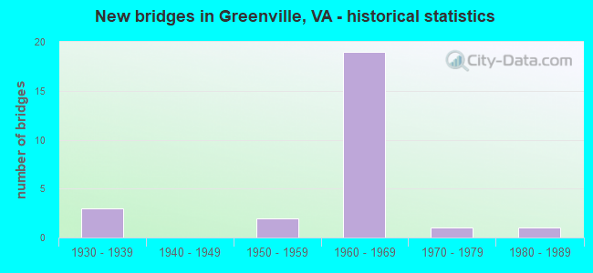
- New bridges - historical statistics
- 31930-1939
- 21950-1959
- 191960-1969
- 11970-1979
- 11980-1989

- Reconstructed bridges - Historical Statistics
- 11940-1949
- 01950-1959
- 01960-1969
- 01970-1979
- 11980-1989
- 01990-1999
- 12000-2009


- Bridge Condition - Deck
- 7.1%Very good
- 14.3%Good
- 64.3%Satisfactory
- 14.3%Fair

- Bridge Condition - Superstructure
- 7.1%Very good
- 7.1%Good
- 50.0%Satisfactory
- 35.7%Fair

- Bridge Condition - Substructure
- 7.1%Good
- 71.4%Satisfactory
- 21.4%Fair

- Bridge Condition - Channel
- 12.5%Very good
- 12.5%Good
- 75.0%Satisfactory

- Bridge Condition - Culverts
- 50.0%Satisfactory
- 50.0%Fair
Find on map >> Show street view
Structure Number: 1685, Location: 0.03 RT 1206- 0.02 RT 662 (Lat: 38.005147, Lng: -79.155503), Route carried "on" structure: US 11, Year Built: 1934, Year Reconstructed: 1949, Status: Open, Structure Length: 1.30m (4.27ft), Average Daily Traffic: 6,807 (year 2020), Truck Traffic: 6%, Average Future Daily Traffic: 8,744 (year 2040), Design Load: H 15, Features Intersected: SOUTH RIVER, Facility Carried by Structure: LEE-JACKSON HWY
Minimum Vertical Clearance: 30+ m (98+ ft), Kilometerpoint: 363.589, Lanes on structure: 2, Owner: State Highway Agency, Approaching Roadway Width: 13.5m (44.3ft), Skew: 3 degrees, Material/Design: Concrete, Design/Construction: Tee Beam, Number Of Spans In Main Unit: 1, Length of Maximum Span: 13.0m (42.7ft), Curb or Sidewalk Widths: Left: 1.6m (5.2ft), Right: 1.6m (5.2ft), Curb-To-Curb Width: 13.5m (44.3ft), Out-to-Out Width: 17.1m (56.1ft)
Condition: Deck: Satisfactory, Superstructure: Satisfactory, Substructure: Satisfactory, Channel: Satisfactory, Operating Rating: 43.5 metric tons, Method Used To Determine Operating Rating: Load and Resistance Factor (LRFR), Inventory Rating: 25.4 metric tons, Method Used To Determine Inventory Rating: Load and Resistance Factor (LRFR), Structural Evaluation: Equal to present minimum criteria, Deck Geometry: Superior to present desirable criteria, Waterway Adequacy: Equal to present minimum criteria, Approach Roadway Alignment: Equal to present desirable criteria, Designated Inspection Frequency: Every 24 months, Inspection Date: September 2020, Deck Structure Type: Concrete Cast-file-Place, Wearing Surface/Protective System: Wearing Surface: Bituminous
Find on map >> Show street view
Structure Number: 1698, Location: 0.04 RT 340 - 0.30 RT 659 (Lat: 38.019456, Lng: -79.140519), Route carried "on" structure: US 11, Year Built: 1950, Status: Open, Structure Length: 1.30m (4.27ft), Average Daily Traffic: 6,807 (year 2020), Truck Traffic: 6%, Average Future Daily Traffic: 8,744 (year 2040), Design Load: H 15, Features Intersected: CHRISTIANS CREEK, Facility Carried by Structure: LEE-JACKSON HWY
Minimum Vertical Clearance: 30+ m (98+ ft), Kilometerpoint: 365.726, Lanes on structure: 4, Owner: State Highway Agency, Approaching Roadway Width: 28.7m (94.2ft), Material/Design: Concrete, Design/Construction: Arch - Deck, Number Of Spans In Main Unit: 2, Length of Maximum Span: 5.3m (17.4ft), Curb-To-Curb Width: 18.9m (62.0ft), Out-to-Out Width: 44.5m (146.0ft)
Condition: Deck: Fair, Superstructure: Fair, Substructure: Fair, Channel: Satisfactory, Operating Rating: 49.0 metric tons, Method Used To Determine Operating Rating: Load and Resistance Factor (LRFR), Inventory Rating: 38.1 metric tons, Method Used To Determine Inventory Rating: Load and Resistance Factor (LRFR), Structural Evaluation: Somewhat better than minimum adequacy, Deck Geometry: Equal to present minimum criteria, Waterway Adequacy: Equal to present minimum criteria, Approach Roadway Alignment: Equal to present desirable criteria, Length Of Structure Improvement: 1.68m (5.51ft), Designated Inspection Frequency: Every 24 months, Inspection Date: November 2021, Bridge Improvement Cost: $21,000, Roadway Improvement Cost: $4,000, Total Project Cost: $25,000, Deck Structure Type: Concrete Cast-file-Place, Wearing Surface/Protective System: Wearing Surface: Bituminous
Find on map >> Show street view
Structure Number: 1699, Location: 1.00 RT 671 - 0.01 RT 666 (Lat: 37.961606, Lng: -79.179761), Route carried "on" structure: US 11, Year Built: 1955, Status: Open, Structure Length: 0.72m (2.36ft), Average Daily Traffic: 4,249 (year 2020), Truck Traffic: 6%, Average Future Daily Traffic: 4,787 (year 2040), Features Intersected: BRANCH POOR CREEK, Facility Carried by Structure: LEE-JACKSON HWY
Minimum Vertical Clearance: 30+ m (98+ ft), Kilometerpoint: 358.237, Lanes on structure: 3, Owner: State Highway Agency, Approaching Roadway Width: 10.4m (34.1ft), Material/Design: Concrete continuous, Design/Construction: Slab, Number Of Spans In Main Unit: 2, Length of Maximum Span: 3.0m (9.8ft), Curb or Sidewalk Widths: Left: 0.3m (1.0ft), Right: 0.3m (1.0ft), Curb-To-Curb Width: 18.2m (59.7ft), Out-to-Out Width: 18.7m (61.4ft)
Condition: Deck: Fair, Superstructure: Fair, Substructure: Fair, Channel: Satisfactory, Operating Rating: 36.3 metric tons, Method Used To Determine Operating Rating: Field evaluation and documented engineering judgment, Inventory Rating: 21.8 metric tons, Method Used To Determine Inventory Rating: Field evaluation and documented engineering judgment, Structural Evaluation: Somewhat better than minimum adequacy, Deck Geometry: Superior to present desirable criteria, Waterway Adequacy: Equal to present minimum criteria, Approach Roadway Alignment: Equal to present desirable criteria, Designated Inspection Frequency: Every 24 months, Inspection Date: November 2021, Deck Structure Type: Concrete Cast-file-Place, Wearing Surface/Protective System: Wearing Surface: Bituminous
Find on map >> Show street view
Structure Number: 1759, Location: 4.53 ROCKBR CO-3.13 RT 11 (Lat: 37.991186, Lng: -79.178111), Route carried "on" structure: Interstate 81, Year Built: 1966, Status: Open, Structure Length: 3.76m (12.34ft), Average Daily Traffic: 21,677 (year 2020), Truck Traffic: 31%, Average Future Daily Traffic: 30,348 (year 2040), Design Load: HS 20+Mod, Features Intersected: RTE 675
Minimum Vertical Clearance: 30+ m (98+ ft), Kilometerpoint: 338.807, Lanes on structure: 2, Lanes under structure: 2, Base Highway Network: Yes, Owner: State Highway Agency, Approaching Roadway Width: 7.9m (25.9ft), Skew: 1 degrees, Material/Design: Concrete, Design/Construction: Stringer/Multi-beam, Number Of Spans In Main Unit: 3, Length of Maximum Span: 13.1m (43.0ft), Curb-To-Curb Width: 12.2m (40.0ft), Out-to-Out Width: 12.8m (42.0ft)
Condition: Deck: Satisfactory, Superstructure: Satisfactory, Substructure: Satisfactory, Operating Rating: 49.0 metric tons, Method Used To Determine Operating Rating: Load and Resistance Factor (LRFR), Inventory Rating: 38.1 metric tons, Method Used To Determine Inventory Rating: Load and Resistance Factor (LRFR), Structural Evaluation: Equal to present minimum criteria, Deck Geometry: Better than present minimum criteria, Underclear: Meets minimum limits, Approach Roadway Alignment: Equal to present desirable criteria, Length Of Structure Improvement: 3.69m (12.11ft), Designated Inspection Frequency: Every 24 months, Inspection Date: May 2021, Bridge Improvement Cost: $46,000, Total Project Cost: $46,000, Deck Structure Type: Concrete Cast-file-Place, Wearing Surface/Protective System: Wearing Surface: Latex Concrete
Find on map >> Show street view
Structure Number: 1761, Location: 4.53 ROCKBR CO-3.13 RT 11 (Lat: 37.991244, Lng: -79.178583), Route carried "on" structure: Interstate 81, Year Built: 1966, Status: Open, Structure Length: 3.51m (11.52ft), Average Daily Traffic: 20,818 (year 2020), Truck Traffic: 30%, Average Future Daily Traffic: 29,145 (year 2040), Design Load: HS 20+Mod, Features Intersected: RTE 675
Minimum Vertical Clearance: 30+ m (98+ ft), Kilometerpoint: 339.322, Lanes on structure: 2, Lanes under structure: 2, Base Highway Network: Yes, Owner: State Highway Agency, Approaching Roadway Width: 7.9m (25.9ft), Material/Design: Concrete, Design/Construction: Stringer/Multi-beam, Number Of Spans In Main Unit: 3, Length of Maximum Span: 12.8m (42.0ft), Curb-To-Curb Width: 12.2m (40.0ft), Out-to-Out Width: 12.8m (42.0ft)
Condition: Deck: Satisfactory, Superstructure: Satisfactory, Substructure: Satisfactory, Operating Rating: 53.5 metric tons, Method Used To Determine Operating Rating: Load and Resistance Factor (LRFR), Inventory Rating: 40.8 metric tons, Method Used To Determine Inventory Rating: Load and Resistance Factor (LRFR), Structural Evaluation: Equal to present minimum criteria, Deck Geometry: Better than present minimum criteria, Underclear: Meets minimum limits, Approach Roadway Alignment: Equal to present desirable criteria, Designated Inspection Frequency: Every 24 months, Inspection Date: May 2021, Bridge Improvement Cost: $42,000, Total Project Cost: $44,000, Deck Structure Type: Concrete Cast-file-Place, Wearing Surface/Protective System: Wearing Surface: Latex Concrete
Find on map >> Show street view
Structure Number: 1765, Location: 6.04 RCKBR CO- 1.62 RT 11 (Lat: 38.010144, Lng: -79.165211), Route carried "on" structure: Interstate 81, Year Built: 1966, Status: Open, Structure Length: 7.00m (22.97ft), Average Daily Traffic: 20,818 (year 2020), Truck Traffic: 30%, Average Future Daily Traffic: 29,145 (year 2040), Design Load: HS 20+Mod, Features Intersected: STOVER SCHOOL RD (662)
Minimum Vertical Clearance: 30+ m (98+ ft), Kilometerpoint: 341.655, Lanes on structure: 2, Lanes under structure: 2, Base Highway Network: Yes, Owner: State Highway Agency, Approaching Roadway Width: 12.8m (42.0ft), Skew: 4 degrees, Material/Design: Steel, Design/Construction: Stringer/Multi-beam, Number Of Spans In Main Unit: 3, Length of Maximum Span: 23.2m (76.1ft), Curb-To-Curb Width: 12.2m (40.0ft), Out-to-Out Width: 12.8m (42.0ft)
Condition: Deck: Satisfactory, Superstructure: Fair, Substructure: Satisfactory, Operating Rating: 58.1 metric tons, Method Used To Determine Operating Rating: Load and Resistance Factor (LRFR), Inventory Rating: 45.4 metric tons, Method Used To Determine Inventory Rating: Load and Resistance Factor (LRFR), Structural Evaluation: Somewhat better than minimum adequacy, Deck Geometry: Better than present minimum criteria, Underclear: Meets minimum limits, Approach Roadway Alignment: Equal to present desirable criteria, Designated Inspection Frequency: Every 24 months, Inspection Date: June 2021, Deck Structure Type: Concrete Cast-file-Place, Wearing Surface/Protective System: Wearing Surface: Latex Concrete
Find on map >> Show street view
Structure Number: 1767, Location: 7.67 RCKBR CO-4.72 RT 654 (Lat: 38.024447, Lng: -79.141111), Route carried "on" structure: Interstate 81, Year Built: 1966, Status: Open, Structure Length: 7.58m (24.87ft), Average Daily Traffic: 20,847 (year 2020), Truck Traffic: 30%, Average Future Daily Traffic: 29,186 (year 2040), Design Load: HS 20+Mod, Features Intersected: RT 11
Minimum Vertical Clearance: 5.54m (18.18ft), Kilometerpoint: 343.811, Lanes on structure: 2, Lanes under structure: 5, Base Highway Network: Yes, Owner: State Highway Agency, Approaching Roadway Width: 12.2m (40.0ft), Skew: 3 degrees, Material/Design: Steel, Design/Construction: Stringer/Multi-beam, Number Of Spans In Main Unit: 4, Length of Maximum Span: 20.3m (66.6ft), Curb-To-Curb Width: 12.2m (40.0ft), Out-to-Out Width: 12.8m (42.0ft)
Condition: Deck: Satisfactory, Superstructure: Satisfactory, Substructure: Satisfactory, Operating Rating: 53.5 metric tons, Method Used To Determine Operating Rating: Load and Resistance Factor (LRFR), Inventory Rating: 41.7 metric tons, Method Used To Determine Inventory Rating: Load and Resistance Factor (LRFR), Structural Evaluation: Equal to present minimum criteria, Deck Geometry: Better than present minimum criteria, Underclear: Meets minimum limits, Approach Roadway Alignment: Equal to present desirable criteria, Designated Inspection Frequency: Every 24 months, Inspection Date: June 2021, Deck Structure Type: Concrete Cast-file-Place, Wearing Surface/Protective System: Wearing Surface: Latex Concrete
Find on map >> Show street view
Structure Number: 1769, Location: 7.67 RCKBR CO-4.72 RT 654 (Lat: 38.024889, Lng: -79.141164), Route carried "on" structure: Interstate 81, Year Built: 1966, Status: Open, Structure Length: 7.60m (24.93ft), Average Daily Traffic: 20,818 (year 2020), Truck Traffic: 30%, Average Future Daily Traffic: 29,145 (year 2040), Design Load: HS 20+Mod, Features Intersected: ROUTE 11
Minimum Vertical Clearance: 30+ m (98+ ft), Kilometerpoint: 344.278, Lanes on structure: 3, Lanes under structure: 5, Base Highway Network: Yes, Owner: State Highway Agency, Approaching Roadway Width: 15.2m (49.9ft), Skew: 3 degrees, Material/Design: Steel, Design/Construction: Stringer/Multi-beam, Number Of Spans In Main Unit: 4, Length of Maximum Span: 21.1m (69.2ft), Curb-To-Curb Width: 15.2m (49.9ft), Out-to-Out Width: 15.8m (51.8ft)
Condition: Deck: Satisfactory, Superstructure: Fair, Substructure: Fair, Operating Rating: 59.0 metric tons, Method Used To Determine Operating Rating: Load and Resistance Factor (LRFR), Inventory Rating: 45.4 metric tons, Method Used To Determine Inventory Rating: Load and Resistance Factor (LRFR), Structural Evaluation: Somewhat better than minimum adequacy, Deck Geometry: Meets minimum limits, Underclear: Meets minimum limits, Approach Roadway Alignment: Equal to present desirable criteria, Designated Inspection Frequency: Every 24 months, Inspection Date: June 2021, Deck Structure Type: Concrete Cast-file-Place, Wearing Surface/Protective System: Wearing Surface: Latex Concrete
Find on map >> Show street view
Structure Number: 1777, Location: 0.15 RT 11 - 3.21 RT 654 (Lat: 38.041389, Lng: -79.123783), Route carried "on" structure: Interstate 81, Year Built: 1968, Status: Open, Structure Length: 3.52m (11.55ft), Average Daily Traffic: 20,847 (year 2020), Truck Traffic: 40%, Average Future Daily Traffic: 29,186 (year 2040), Design Load: HS 20+Mod, Features Intersected: RT 694
Minimum Vertical Clearance: 30+ m (98+ ft), Kilometerpoint: 346.289, Lanes on structure: 2, Lanes under structure: 2, Base Highway Network: Yes, Owner: State Highway Agency, Approaching Roadway Width: 12.8m (42.0ft), Skew: 1 degrees, Material/Design: Concrete continuous, Design/Construction: Tee Beam, Number Of Spans In Main Unit: 3, Length of Maximum Span: 12.4m (40.7ft), Curb-To-Curb Width: 12.2m (40.0ft), Out-to-Out Width: 12.8m (42.0ft)
Condition: Deck: Good, Superstructure: Good, Substructure: Satisfactory, Operating Rating: 54.4 metric tons, Method Used To Determine Operating Rating: Load and Resistance Factor (LRFR), Inventory Rating: 41.7 metric tons, Method Used To Determine Inventory Rating: Load and Resistance Factor (LRFR), Structural Evaluation: Equal to present minimum criteria, Deck Geometry: Better than present minimum criteria, Approach Roadway Alignment: Equal to present desirable criteria, Designated Inspection Frequency: Every 24 months, Inspection Date: June 2021, Bridge Improvement Cost: $44,000, Total Project Cost: $46,000, Deck Structure Type: Concrete Cast-file-Place, Wearing Surface/Protective System: Wearing Surface: Latex Concrete
Find on map >> Show street view
Structure Number: 1779, Location: 1.51 RT 11 - 7.03 RT 64 (Lat: 38.041736, Lng: -79.124278), Route carried "on" structure: Interstate 81, Year Built: 1968, Status: Open, Structure Length: 3.70m (12.14ft), Average Daily Traffic: 20,681 (year 2020), Truck Traffic: 30%, Average Future Daily Traffic: 28,953 (year 2040), Design Load: HS 20+Mod, Features Intersected: RT 694
Minimum Vertical Clearance: 30+ m (98+ ft), Kilometerpoint: 346.756, Lanes on structure: 2, Lanes under structure: 2, Base Highway Network: Yes, Owner: State Highway Agency, Approaching Roadway Width: 12.8m (42.0ft), Skew: 1 degrees, Material/Design: Concrete, Design/Construction: Tee Beam, Number Of Spans In Main Unit: 3, Length of Maximum Span: 13.1m (43.0ft), Curb-To-Curb Width: 12.2m (40.0ft), Out-to-Out Width: 12.8m (42.0ft)
Condition: Deck: Good, Superstructure: Satisfactory, Substructure: Satisfactory, Operating Rating: 53.5 metric tons, Method Used To Determine Operating Rating: Load and Resistance Factor (LRFR), Inventory Rating: 40.8 metric tons, Method Used To Determine Inventory Rating: Load and Resistance Factor (LRFR), Structural Evaluation: Equal to present minimum criteria, Deck Geometry: Better than present minimum criteria, Underclear: Meets minimum limits, Approach Roadway Alignment: Equal to present desirable criteria, Designated Inspection Frequency: Every 24 months, Inspection Date: June 2021, Bridge Improvement Cost: $44,000, Total Project Cost: $46,000, Deck Structure Type: Concrete Cast-file-Place, Wearing Surface/Protective System: Wearing Surface: Latex Concrete
Find on map >> Show street view
Structure Number: 1797, Location: 6.50 ROCKBR CL-1.16 RT 11 (Lat: 38.014003, Lng: -79.157386), Route carried "on" structure: Interstate 81, Year Built: 1966, Status: Open, Structure Length: 1.06m (3.48ft), Average Daily Traffic: 21,677 (year 2020), Truck Traffic: 29%, Average Future Daily Traffic: 30,348 (year 2040), Design Load: HS 20, Features Intersected: CHRISTIANS CREEK
Minimum Vertical Clearance: 30+ m (98+ ft), Kilometerpoint: 341.977, Lanes on structure: 2, Base Highway Network: Yes, Owner: State Highway Agency, Approaching Roadway Width: 12.8m (42.0ft), Skew: 2 degrees, Material/Design: Concrete, Design/Construction: Culvert, Number Of Spans In Main Unit: 3, Length of Maximum Span: 3.0m (9.8ft)
Condition: Channel: Satisfactory, Culverts: Fair, Operating Rating: 89.8 metric tons, Method Used To Determine Operating Rating: Field evaluation and documented engineering judgment, Inventory Rating: 88.9 metric tons, Method Used To Determine Inventory Rating: Field evaluation and documented engineering judgment, Structural Evaluation: Somewhat better than minimum adequacy, Waterway Adequacy: Equal to present desirable criteria, Approach Roadway Alignment: Equal to present desirable criteria, Designated Inspection Frequency: Every 24 months, Inspection Date: Febuary 2022
Find on map >> Show street view
Structure Number: 2101, Location: 0.35 RT 657 - 1.10 RT 608 (Lat: 38.016583, Lng: -79.114386), Route carried "on" structure: County highway 658, Year Built: 1932, Year Reconstructed: 1987, Status: Open, Structure Length: 1.16m (3.81ft), Average Daily Traffic: 162 (year 2017), Average Future Daily Traffic: 237 (year 2040), Design Load: HS 20+Mod, Features Intersected: SOUTH RIVER, Facility Carried by Structure: AVIS RD
Minimum Vertical Clearance: 30+ m (98+ ft), Kilometerpoint: 0.563, Lanes on structure: 2, Owner: State Highway Agency, Approaching Roadway Width: 5.5m (18.0ft), Skew: 3 degrees, Material/Design: Steel, Design/Construction: Stringer/Multi-beam, Number Of Spans In Main Unit: 1, Length of Maximum Span: 10.4m (34.1ft), Curb-To-Curb Width: 7.1m (23.3ft), Out-to-Out Width: 7.4m (24.3ft)
Condition: Deck: Satisfactory, Superstructure: Fair, Substructure: Satisfactory, Channel: Very good, Operating Rating: 41.7 metric tons, Method Used To Determine Operating Rating: Load Factor (LF), Inventory Rating: 24.5 metric tons, Method Used To Determine Inventory Rating: Load Factor (LF), Structural Evaluation: Somewhat better than minimum adequacy, Deck Geometry: Meets minimum limits, Waterway Adequacy: Equal to present minimum criteria, Approach Roadway Alignment: Somewhat better than minimum adequacy, Designated Inspection Frequency: Every 24 months, Inspection Date: October 2021, Deck Structure Type: Wood or Timber, Wearing Surface/Protective System: Wearing Surface: Bituminous
Find on map >> Show street view
Structure Number: 2102, Location: 0.40 RT 657 - 1.05 RT 608 (Lat: 38.016094, Lng: -79.114044), Route carried "on" structure: County highway 658, Year Built: 1984, Status: Open, Structure Length: 0.93m (3.05ft), Average Daily Traffic: 162 (year 2017), Average Future Daily Traffic: 237 (year 2040), Features Intersected: PINE RUN, Facility Carried by Structure: AVIS RD
Minimum Vertical Clearance: 30+ m (98+ ft), Kilometerpoint: 0.644, Lanes on structure: 2, Owner: State Highway Agency, Approaching Roadway Width: 5.1m (16.7ft), Skew: 3 degrees, Material/Design: Steel, Design/Construction: Stringer/Multi-beam, Number Of Spans In Main Unit: 1, Length of Maximum Span: 8.4m (27.6ft), Curb-To-Curb Width: 6.9m (22.6ft), Out-to-Out Width: 7.3m (24.0ft)
Condition: Deck: Satisfactory, Superstructure: Satisfactory, Substructure: Good, Channel: Satisfactory, Operating Rating: 56.2 metric tons, Method Used To Determine Operating Rating: Load Factor (LF), Inventory Rating: 33.6 metric tons, Method Used To Determine Inventory Rating: Load Factor (LF), Structural Evaluation: Equal to present minimum criteria, Deck Geometry: Meets minimum limits, Waterway Adequacy: Somewhat better than minimum adequacy, Approach Roadway Alignment: Equal to present minimum criteria, Designated Inspection Frequency: Every 24 months, Inspection Date: May 2021, Deck Structure Type: Wood or Timber, Wearing Surface/Protective System: Wearing Surface: Wood or Timber
Find on map >> Show street view
Structure Number: 2104, Location: 0.39 TO 613 - 0.17 TO1201 (Lat: 38.006967, Lng: -79.161156), Route carried "on" structure: County highway 662, Year Built: 1971, Year Reconstructed: 2013, Status: Open, Structure Length: 2.45m (8.04ft), Average Daily Traffic: 437 (year 2013), Average Future Daily Traffic: 582 (year 2040), Features Intersected: SOUTH RIVER, Facility Carried by Structure: STOVER SCHOOL RD
Minimum Vertical Clearance: 30+ m (98+ ft), Kilometerpoint: 6.122, Lanes on structure: 2, Owner: State Highway Agency, Approaching Roadway Width: 5.8m (19.0ft), Material/Design: Prestressed concrete, Design/Construction: Slab, Number Of Spans In Main Unit: 2, Length of Maximum Span: 11.5m (37.7ft), Curb-To-Curb Width: 7.0m (23.0ft), Out-to-Out Width: 7.2m (23.6ft)
Condition: Deck: Very good, Superstructure: Very good, Substructure: Satisfactory, Channel: Good, Operating Rating: 54.4 metric tons, Method Used To Determine Operating Rating: Load and Resistance Factor (LRFR), Inventory Rating: 41.7 metric tons, Method Used To Determine Inventory Rating: Load and Resistance Factor (LRFR), Structural Evaluation: Equal to present minimum criteria, Deck Geometry: Meets minimum limits, Waterway Adequacy: Equal to present minimum criteria, Approach Roadway Alignment: Meets minimum limits, Designated Inspection Frequency: Every 24 months, Inspection Date: May 2021, Deck Structure Type: Other, Wearing Surface/Protective System: Wearing Surface: Bituminous
Find on map >> Show street view
Structure Number: 2114, Location: 0.07 RT F215-0.28 RT F214 (Lat: 37.979211, Lng: -79.185022), Route carried "on" structure: County highway 671, Year Built: 1966, Status: Open, Structure Length: 10.34m (33.92ft), Average Daily Traffic: 361 (year 2013), Average Future Daily Traffic: 471 (year 2040), Design Load: HS 20+Mod, Features Intersected: RTE 81, Facility Carried by Structure: ALMO CHAPEL RD.
Minimum Vertical Clearance: 30+ m (98+ ft), Kilometerpoint: 4.450, Lanes on structure: 2, Lanes under structure: 4, Owner: State Highway Agency, Approaching Roadway Width: 7.9m (25.9ft), Skew: 2 degrees, Material/Design: Prestressed concrete, Design/Construction: Stringer/Multi-beam, Number Of Spans In Main Unit: 5, Length of Maximum Span: 22.0m (72.2ft), Curb or Sidewalk Widths: Left: 0.5m (1.6ft), Right: 0.5m (1.6ft), Curb-To-Curb Width: 7.3m (24.0ft), Out-to-Out Width: 8.8m (28.9ft)
Condition: Deck: Satisfactory, Superstructure: Satisfactory, Substructure: Satisfactory, Operating Rating: 88.9 metric tons, Method Used To Determine Operating Rating: Load and Resistance Factor (LRFR), Inventory Rating: 52.6 metric tons, Method Used To Determine Inventory Rating: Load and Resistance Factor (LRFR), Structural Evaluation: Equal to present minimum criteria, Deck Geometry: Somewhat better than minimum adequacy, Underclear: Meets minimum limits, Approach Roadway Alignment: Better than present minimum criteria, Designated Inspection Frequency: Every 24 months, Inspection Date: Febuary 2021, Bridge Improvement Cost: $54,000, Total Project Cost: $57,000, Deck Structure Type: Concrete Cast-file-Place, Wearing Surface/Protective System: Wearing Surface: Bituminous
Find on map >> Show street view
Structure Number: 2402, Location: 1.17 RT 675 - 2.04 RT 620 (Lat: 37.981844, Lng: -79.200511), Route carried "on" structure: County highway 919, Year Built: 1932, Status: Open, Structure Length: 0.95m (3.12ft), Average Daily Traffic: 527 (year 2017), Average Future Daily Traffic: 656 (year 2040), Design Load: HS 20, Features Intersected: TRIB OF SOUTH RIVER, Facility Carried by Structure: OLD PROVIDENCE RD
Minimum Vertical Clearance: 30+ m (98+ ft), Kilometerpoint: 5.438, Lanes on structure: 2, Owner: State Highway Agency, Approaching Roadway Width: 5.5m (18.0ft), Skew: 4 degrees, Material/Design: Concrete, Design/Construction: Culvert, Number Of Spans In Main Unit: 3, Length of Maximum Span: 3.0m (9.8ft)
Condition: Channel: Satisfactory, Culverts: Satisfactory, Operating Rating: 46.3 metric tons, Method Used To Determine Operating Rating: Field evaluation and documented engineering judgment, Inventory Rating: 27.2 metric tons, Method Used To Determine Inventory Rating: Field evaluation and documented engineering judgment, Structural Evaluation: Equal to present minimum criteria, Waterway Adequacy: Somewhat better than minimum adequacy, Approach Roadway Alignment: Equal to present minimum criteria, Designated Inspection Frequency: Every 24 months, Inspection Date: May 2021
Find on map >> Show street view
Structure Number: 1759, Location: 4.53 ROCKBR CO-3.13 RT 11 (Lat: 37.991186, Lng: -79.178111), Route carried "under" structure: County highway 675, Year Built: 1966, Structure Length: 0. m, Average Daily Traffic: 720 (year 2018), Truck Traffic: 3%, Features Intersected: RTE 675, Facility Carried by Structure: NBL ROUTE 0081
Minimum Vertical Clearance: 5.39m (17.68ft), Kilometerpoint: 10.861, Lanes on structure: 2, Lanes under structure: 2, Material/Design: Concrete, Design/Construction: Stringer/Multi-beam, Length of Maximum Span: 13.1m (43.0ft)
Find on map >> Show street view
Structure Number: 1761, Location: 4.53 ROCKBR CO-3.13 RT 11 (Lat: 37.991244, Lng: -79.178583), Route carried "under" structure: County highway 675, Year Built: 1966, Structure Length: 0. m, Average Daily Traffic: 720 (year 2018), Truck Traffic: 3%, Features Intersected: RTE 675, Facility Carried by Structure: SBL ROUTE 0081
Minimum Vertical Clearance: 5.59m (18.34ft), Kilometerpoint: 10.796, Lanes on structure: 2, Lanes under structure: 2, Material/Design: Concrete, Design/Construction: Stringer/Multi-beam, Length of Maximum Span: 12.8m (42.0ft)
Find on map >> Show street view
Structure Number: 1763, Location: 6.08 RCKBR CO- 1.58 RT 11 (Lat: 38.009939, Lng: -79.163719), Route carried "under" structure: County highway 662, Year Built: 1966, Structure Length: 0. m, Average Daily Traffic: 440 (year 2018), Features Intersected: STOVER SCHOOL RD (662), Facility Carried by Structure: I-81 NBL
Minimum Vertical Clearance: 5.23m (17.16ft), Kilometerpoint: 5.648, Lanes on structure: 2, Lanes under structure: 2, Material/Design: Concrete, Design/Construction: Tee Beam, Length of Maximum Span: 14.8m (48.6ft)
Find on map >> Show street view
Structure Number: 1765, Location: 6.04 RCKBR CO- 1.62 RT 11 (Lat: 38.010144, Lng: -79.165211), Route carried "under" structure: Interstate 662, Year Built: 1966, Structure Length: 0. m, Average Daily Traffic: 440 (year 2018), Features Intersected: STOVER SCHOOL RD (662), Facility Carried by Structure: I-81 SBL
Minimum Vertical Clearance: 9.65m (31.66ft), Kilometerpoint: 5.599, Lanes on structure: 2, Lanes under structure: 2, Material/Design: Steel, Design/Construction: Stringer/Multi-beam, Length of Maximum Span: 23.2m (76.1ft)
Find on map >> Show street view
Structure Number: 1767, Location: 7.67 RCKBR CO-4.72 RT 654 (Lat: 38.024447, Lng: -79.141111), Route carried "under" structure: US 11, Year Built: 1966, Structure Length: 0. m, Average Daily Traffic: 3,600 (year 2018), Truck Traffic: 3%, Features Intersected: RT 11, Facility Carried by Structure: I-81 NBL
Minimum Vertical Clearance: 5.54m (18.18ft), Kilometerpoint: 366.364, Lanes on structure: 2, Lanes under structure: 5, Material/Design: Steel, Design/Construction: Stringer/Multi-beam, Length of Maximum Span: 20.3m (66.6ft)
Find on map >> Show street view
Structure Number: 1769, Location: 7.67 RCKBR CO-4.72 RT 654 (Lat: 38.024889, Lng: -79.141164), Route carried "under" structure: US 11, Year Built: 1966, Structure Length: 0. m, Average Daily Traffic: 3,600 (year 2018), Truck Traffic: 3%, Features Intersected: ROUTE 11, Facility Carried by Structure: I-81 SBL
Minimum Vertical Clearance: 5.18m (16.99ft), Kilometerpoint: 366.381, Lanes on structure: 3, Lanes under structure: 5, Material/Design: Steel, Design/Construction: Stringer/Multi-beam, Length of Maximum Span: 21.1m (69.2ft)
Find on map >> Show street view
Structure Number: 1777, Location: 0.15 RT 11 - 3.21 RT 654 (Lat: 38.041389, Lng: -79.123783), Route carried "under" structure: County highway 694, Year Built: 1968, Structure Length: 0. m, Average Daily Traffic: 440 (year 2020), Features Intersected: RT 694, Facility Carried by Structure: NBL ROUTE 0081
Minimum Vertical Clearance: 5.03m (16.50ft), Kilometerpoint: 12.840, Lanes on structure: 2, Lanes under structure: 2, Material/Design: Concrete continuous, Design/Construction: Tee Beam, Length of Maximum Span: 12.4m (40.7ft)
Find on map >> Show street view
Structure Number: 1779, Location: 1.51 RT 11 - 7.03 RT 64 (Lat: 38.041736, Lng: -79.124278), Route carried "under" structure: County highway 694, Year Built: 1968, Structure Length: 0. m, Average Daily Traffic: 440 (year 2018), Features Intersected: RT 694, Facility Carried by Structure: SBL ROUTE 0081
Minimum Vertical Clearance: 5.92m (19.42ft), Kilometerpoint: 12.792, Lanes on structure: 2, Lanes under structure: 2, Material/Design: Concrete, Design/Construction: Tee Beam, Length of Maximum Span: 13.1m (43.0ft)
Find on map >> Show street view
Structure Number: 2024, Location: 0.42 RT 671- 0.03 RT F213 (Lat: 37.953461, Lng: -79.209178), Route carried "under" structure: Interstate 81, Year Built: 1965, Structure Length: 0. m, Average Daily Traffic: 48,000 (year 2018), Truck Traffic: 30%, Features Intersected: RTE I-81, Facility Carried by Structure: SPOTTSWOOD RD
Minimum Vertical Clearance: 5.80m (19.03ft), Kilometerpoint: 333.755, Lanes on structure: 2, Lanes under structure: 4, Material/Design: Prestressed concrete, Design/Construction: Stringer/Multi-beam, Length of Maximum Span: 22.9m (75.1ft)
Find on map >> Show street view
Structure Number: 2114, Location: 0.07 RT F215-0.28 RT F214 (Lat: 37.979211, Lng: -79.185022), Route carried "under" structure: Interstate 81, Year Built: 1966, Structure Length: 0. m, Average Daily Traffic: 41,121 (year 2008), Truck Traffic: 15%, Features Intersected: RTE 81, Facility Carried by Structure: ALMO CHAPEL RD.
Minimum Vertical Clearance: 6.35m (20.83ft), Kilometerpoint: 337.343, Lanes on structure: 2, Lanes under structure: 4, Material/Design: Prestressed concrete, Design/Construction: Stringer/Multi-beam, Length of Maximum Span: 22.0m (72.2ft)