Bridge Statistics for Greenwood Village, Colorado (CO)
Condition, Traffic, Stress, Structural Evaluation, Project Costs
- National Bridge Inventory (NBI) Statistics
- 29Number of bridges
- 308ft / 93.8mTotal length
- $3,435,000Total costs
- 1,261,678Total average daily traffic
- 65,411Total average daily truck traffic
- National Bridge Inventory (NBI) Registered Bridges for Greenwood Village
- No street view available for this location
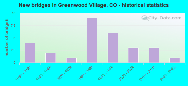
- New bridges - historical statistics
- 41950-1959
- 21960-1969
- 11970-1979
- 91980-1989
- 61990-1999
- 32000-2009
- 32010-2019
- 12020-2022

- Reconstructed bridges - Historical Statistics
- 11970-1979
- 11980-1989


- Bridge Condition - Deck
- 47.1%Good
- 47.1%Satisfactory
- 5.9%Fair

- Bridge Condition - Superstructure
- 5.9%Very good
- 41.2%Good
- 41.2%Satisfactory
- 11.8%Fair

- Bridge Condition - Substructure
- 5.9%Very good
- 64.7%Good
- 29.4%Satisfactory

- Bridge Condition - Channel
- 78.6%Very good
- 21.4%Satisfactory

- Bridge Condition - Culverts
- 80.0%Good
- 20.0%Satisfactory
Find on map >> Show street view
Structure Number: F-17-AB, Location: GRNWD VILLAGE @ FIRE STAT (Lat: 39.615047, Lng: -104.959828), Route carried "on" structure: State highway 177A, Year Built: 1965, Status: Open, Structure Length: 1.49m (4.89ft), Average Daily Traffic: 29,000 (year 2020), Truck Traffic: 2%, Average Future Daily Traffic: 29,580 (year 2040), Design Load: HS 25 or greater, Features Intersected: HIGHLINE CANAL, Facility Carried by Structure: SH177ML-UNIVERSITY
Minimum Vertical Clearance: 30+ m (98+ ft), Kilometerpoint: 6.030, Lanes on structure: 4, Base Highway Network: Yes, Owner: State Highway Agency, Approaching Roadway Width: 20.4m (66.9ft), Skew: 3 degrees, Material/Design: Concrete, Design/Construction: Culvert, Number Of Spans In Main Unit: 2, Length of Maximum Span: 7.4m (24.3ft), Curb or Sidewalk Widths: Left: 2.3m (7.5ft), Right: 2.4m (7.9ft), Curb-To-Curb Width: 20.4m (66.9ft), Out-to-Out Width: 28.1m (92.2ft)
Condition: Channel: Very good, Culverts: Good, Operating Rating: 38.5 metric tons, Method Used To Determine Operating Rating: Load Factor (LF), Inventory Rating: 23.0 metric tons, Method Used To Determine Inventory Rating: Load Factor (LF), Structural Evaluation: Somewhat better than minimum adequacy, Deck Geometry: Superior to present desirable criteria, Waterway Adequacy: Superior to present desirable criteria, Approach Roadway Alignment: Equal to present desirable criteria, Designated Inspection Frequency: Every 24 months, Inspection Date: November 2020
Find on map >> Show street view
Structure Number: F-17-CF, Location: HAMPDEN/WELLSHIRE G.C. (Lat: 39.653014, Lng: -104.946397), Route carried "on" structure: US 285D, Year Built: 1960, Status: Open, Structure Length: 1.49m (4.89ft), Average Daily Traffic: 52,000 (year 2020), Truck Traffic: 3%, Average Future Daily Traffic: 56,680 (year 2040), Design Load: HS 20, Features Intersected: HIGHLINE CANAL, Facility Carried by Structure: US 285 ML
Minimum Vertical Clearance: 30+ m (98+ ft), Kilometerpoint: 161.536, Lanes on structure: 7, Base Highway Network: Yes, Owner: State Highway Agency, Approaching Roadway Width: 21.9m (71.9ft), Skew: 4 degrees, Material/Design: Concrete, Design/Construction: Tee Beam, Number Of Spans In Main Unit: 1, Length of Maximum Span: 14.0m (45.9ft), Curb-To-Curb Width: 25.0m (82.0ft), Out-to-Out Width: 27.4m (89.9ft)
Condition: Deck: Satisfactory, Superstructure: Satisfactory, Substructure: Satisfactory, Channel: Very good, Operating Rating: 68.7 metric tons, Method Used To Determine Operating Rating: Load Factor (LF), Inventory Rating: 41.1 metric tons, Method Used To Determine Inventory Rating: Load Factor (LF), Structural Evaluation: Equal to present minimum criteria, Deck Geometry: High priority of replacement, Waterway Adequacy: Equal to present desirable criteria, Approach Roadway Alignment: Equal to present desirable criteria, Length Of Structure Improvement: 1.49m (4.89ft), Designated Inspection Frequency: Every 24 months, Inspection Date: March 2021, Bridge Improvement Cost: $159,000, Roadway Improvement Cost: $16,000, Total Project Cost: $238,000, Deck Structure Type: Concrete Cast-file-Place, Wearing Surface/Protective System: Wearing Surface: Bituminous
Find on map >> Show street view
Structure Number: F-17-CO, Location: BELLEVIEW & I25 (Lat: 39.623519, Lng: -104.901089), Route carried "on" structure: Interstate 25A, Year Built: 1958, Year Reconstructed: 1975, Status: Open, Structure Length: 6.53m (21.42ft), Average Daily Traffic: 246,000 (year 2020), Truck Traffic: 5%, Average Future Daily Traffic: 312,420 (year 2040), Design Load: HS 20, Features Intersected: SH 88 ML W./BELLEVIEW, Facility Carried by Structure: I 25 ML
Minimum Vertical Clearance: 30+ m (98+ ft), Kilometerpoint: 320.551, Lanes on structure: 10, Lanes under structure: 8, Base Highway Network: Yes, Owner: State Highway Agency, Approaching Roadway Width: 48.8m (160.1ft), Skew: 32 degrees, Material/Design: Concrete continuous, Design/Construction: Tee Beam, Number Of Spans In Main Unit: 4, Length of Maximum Span: 18.9m (62.0ft), Curb-To-Curb Width: 49.4m (162.1ft), Out-to-Out Width: 50.3m (165.0ft)
Condition: Deck: Satisfactory, Superstructure: Satisfactory, Substructure: Good, Operating Rating: 41.4 metric tons, Method Used To Determine Operating Rating: Load Factor (LF), Inventory Rating: 24.9 metric tons, Method Used To Determine Inventory Rating: Load Factor (LF), Structural Evaluation: Equal to present minimum criteria, Deck Geometry: Superior to present desirable criteria, Underclear: High priority of corrective action, Approach Roadway Alignment: Equal to present desirable criteria, Length Of Structure Improvement: 6.53m (21.42ft), Designated Inspection Frequency: Every 24 months, Inspection Date: March 2020, Deck Structure Type: Other, Wearing Surface/Protective System: Wearing Surface: Bituminous, Membrane: Preformed Fabric
Find on map >> Show street view
Structure Number: F-17-DE, Location: 1.1 MI NO OF JCT SH 88 EA (Lat: 39.609022, Lng: -104.892789), Route carried "on" structure: Interstate 25A, Year Built: 1958, Year Reconstructed: 1987, Status: Open, Structure Length: 5.13m (16.83ft), Average Daily Traffic: 233,000 (year 2020), Truck Traffic: 6%, Average Future Daily Traffic: 298,240 (year 2040), Design Load: HS 20+Mod, Features Intersected: ORCHARD ROAD, Facility Carried by Structure: I 25 ML
Minimum Vertical Clearance: 30+ m (98+ ft), Kilometerpoint: 318.795, Lanes on structure: 10, Lanes under structure: 7, Base Highway Network: Yes, Owner: State Highway Agency, Approaching Roadway Width: 48.8m (160.1ft), Skew: 32 degrees, Material/Design: Concrete continuous, Design/Construction: Tee Beam, Number Of Spans In Main Unit: 3, Length of Maximum Span: 20.7m (67.9ft), Curb-To-Curb Width: 48.8m (160.1ft), Out-to-Out Width: 50.4m (165.4ft)
Condition: Deck: Good, Superstructure: Good, Substructure: Satisfactory, Operating Rating: 51.3 metric tons, Method Used To Determine Operating Rating: Load Factor (LF), Inventory Rating: 30.8 metric tons, Method Used To Determine Inventory Rating: Load Factor (LF), Structural Evaluation: Equal to present minimum criteria, Deck Geometry: Superior to present desirable criteria, Underclear: High priority of corrective action, Approach Roadway Alignment: Equal to present desirable criteria, Designated Inspection Frequency: Every 24 months, Inspection Date: March 2020, Deck Structure Type: Other, Wearing Surface/Protective System: Wearing Surface: Bituminous, Membrane: Preformed Fabric, Deck Protection: Epoxy Coated Reinforcing
Find on map >> Show street view
Structure Number: F-17-OD, Location: I25 TO I225 RAMP (Lat: 39.633997, Lng: -104.905186), Route carried "on" structure: Ramp Interstate 225A, Year Built: 2005, Status: Open, Structure Length: 43.82m (143.77ft), Average Daily Traffic: 69,000 (year 2020), Truck Traffic: 6%, Average Future Daily Traffic: 86,250 (year 2040), Design Load: HS 25 or greater, Features Intersected: I25 ML, Facility Carried by Structure: NB 225 RAMP
Minimum Vertical Clearance: 30+ m (98+ ft), Kilometerpoint: 0.785, Lanes on structure: 2, Lanes under structure: 12, Base Highway Network: Yes, Owner: State Highway Agency, Approaching Roadway Width: 11.6m (38.1ft), Skew: 9 degrees, Material/Design: Steel continuous, Design/Construction: Stringer/Multi-beam, Number Of Spans In Main Unit: 10, Length of Maximum Span: 61.0m (200.1ft), Curb-To-Curb Width: 11.6m (38.1ft), Out-to-Out Width: 12.6m (41.3ft)
Condition: Deck: Satisfactory, Superstructure: Good, Substructure: Satisfactory, Operating Rating: 39.1 metric tons, Method Used To Determine Operating Rating: Load Factor (LF), Inventory Rating: 39.0 metric tons, Method Used To Determine Inventory Rating: Load Factor (LF), Structural Evaluation: Equal to present minimum criteria, Deck Geometry: Superior to present desirable criteria, Approach Roadway Alignment: Equal to present desirable criteria, Designated Inspection Frequency: Every 24 months, Inspection Date: January 2022, Deck Structure Type: Concrete Cast-file-Place, Wearing Surface/Protective System: Wearing Surface: Monolithic Concrete, Deck Protection: Epoxy Coated Reinforcing
Find on map >> Show street view
Structure Number: F-17-XH, Location: 0.1 MI SW ARAPAHOE ROAD (Lat: 39.593342, Lng: -104.797417), Route carried "on" structure: Ramp State highway 83A, Year Built: 2015, Status: Open, Structure Length: 0.64m (2.10ft), Average Daily Traffic: 41,000 (year 2020), Truck Traffic: 4%, Average Future Daily Traffic: 51,660 (year 2040), Design Load: HL 93, Features Intersected: Multi-use Path, Facility Carried by Structure: SH 83 RAMP
Minimum Vertical Clearance: 30.45m (99.90ft), Kilometerpoint: 0.186, Lanes on structure: 2, Owner: State Highway Agency, Approaching Roadway Width: 21.0m (68.9ft), Skew: 21 degrees, Material/Design: Concrete, Design/Construction: Culvert, Number Of Spans In Main Unit: 1, Length of Maximum Span: 6.4m (21.0ft), Out-to-Out Width: 36.6m (120.1ft)
Condition: Culverts: Good, Operating Rating: 36.3 metric tons, Method Used To Determine Operating Rating: Field evaluation and documented engineering judgment, Inventory Rating: 32.7 metric tons, Method Used To Determine Inventory Rating: Field evaluation and documented engineering judgment, Structural Evaluation: Better than present minimum criteria, Approach Roadway Alignment: Equal to present desirable criteria, Designated Inspection Frequency: Every 24 months, Inspection Date: June 2021
Find on map >> Show street view
Structure Number: F-17-XL, Location: ARAPAHOE RD Ramp I25 (Lat: 39.594758, Lng: -104.884847), Route carried "on" structure: Interstate 25A, Year Built: 2017, Status: Open, Structure Length: 6.81m (22.34ft), Average Daily Traffic: 212,000 (year 2020), Truck Traffic: 7%, Average Future Daily Traffic: 284,080 (year 2040), Design Load: HL 93, Features Intersected: SH 88 ML EAST, Facility Carried by Structure: I 25 ML
Minimum Vertical Clearance: 30+ m (98+ ft), Kilometerpoint: 317.065, Lanes on structure: 12, Lanes under structure: 8, Base Highway Network: Yes, Owner: State Highway Agency, Approaching Roadway Width: 59.7m (195.9ft), Skew: 32 degrees, Material/Design: Prestressed concrete continuous, Design/Construction: Box Beam or Girders - Multiple, Number Of Spans In Main Unit: 2, Length of Maximum Span: 36.6m (120.1ft), Curb-To-Curb Width: 64.0m (210.0ft), Out-to-Out Width: 65.5m (214.9ft)
Condition: Deck: Good, Superstructure: Good, Substructure: Good, Operating Rating: 42.1 metric tons, Method Used To Determine Operating Rating: Load and Resistance Factor Rating (LRFR) rating reported by rating factor(RF) method using HL-93 loadings, Inventory Rating: 32.4 metric tons, Method Used To Determine Inventory Rating: Load and Resistance Factor Rating (LRFR) rating reported by rating factor(RF) method using HL-93 loadings, Structural Evaluation: Better than present minimum criteria, Deck Geometry: Superior to present desirable criteria, Underclear: High priority of corrective action, Approach Roadway Alignment: Equal to present desirable criteria, Designated Inspection Frequency: Every 24 months, Inspection Date: Febuary 2020, Deck Structure Type: Concrete Cast-file-Place, Wearing Surface/Protective System: Wearing Surface: Bituminous, Membrane: Preformed Fabric
Find on map >> Show street view
Structure Number: GWDV-03-0.40-01, Location: .4 MI W OF UNIVERSITY (Lat: 39.612733, Lng: -104.969983), Route carried "on" structure: City street , Year Built: 1975, Status: Open, Structure Length: 1.00m (3.28ft), Average Daily Traffic: 316 (year 2021), Truck Traffic: 2%, Average Future Daily Traffic: 385 (year 2041), Features Intersected: HIGHLINE CANAL, Facility Carried by Structure: GREEN OAKS DR
Minimum Vertical Clearance: 30+ m (98+ ft), Kilometerpoint: 1.419, Lanes on structure: 2, Owner: City or Municipal Highway Agency, Approaching Roadway Width: 9.1m (29.9ft), Material/Design: Concrete, Design/Construction: Slab, Number Of Spans In Main Unit: 1, Length of Maximum Span: 9.3m (30.5ft), Curb or Sidewalk Widths: Left: 2.1m (6.9ft), Right: 1.2m (3.9ft), Curb-To-Curb Width: 7.9m (25.9ft), Out-to-Out Width: 11.9m (39.0ft)
Condition: Deck: Satisfactory, Superstructure: Satisfactory, Substructure: Good, Channel: Very good, Operating Rating: 36.3 metric tons, Method Used To Determine Operating Rating: Field evaluation and documented engineering judgment, Inventory Rating: 32.7 metric tons, Method Used To Determine Inventory Rating: Field evaluation and documented engineering judgment, Structural Evaluation: Equal to present minimum criteria, Deck Geometry: Somewhat better than minimum adequacy, Waterway Adequacy: Equal to present desirable criteria, Approach Roadway Alignment: Better than present minimum criteria, Designated Inspection Frequency: Every 24 months, Inspection Date: September 2021, Deck Structure Type: Concrete Cast-file-Place, Wearing Surface/Protective System: Wearing Surface: Bituminous
Find on map >> Show street view
Structure Number: GWDV-04-0.35-1A, Location: .5 MI S OF BELLEVIEW (Lat: 39.619192, Lng: -104.969281), Route carried "on" structure: City street , Year Built: 1989, Status: Open, Structure Length: 0.91m (2.99ft), Average Daily Traffic: 623 (year 2021), Truck Traffic: 2%, Average Future Daily Traffic: 760 (year 2041), Design Load: HS 20, Features Intersected: HIGHLINE CANAL, Facility Carried by Structure: FRANKLIN ST
Minimum Vertical Clearance: 30+ m (98+ ft), Kilometerpoint: 0.517, Lanes on structure: 2, Owner: City or Municipal Highway Agency, Approaching Roadway Width: 8.5m (27.9ft), Material/Design: Concrete, Design/Construction: Frame, Number Of Spans In Main Unit: 1, Length of Maximum Span: 8.5m (27.9ft), Curb or Sidewalk Widths: Left: 1.2m (3.9ft), Right: 1.2m (3.9ft), Curb-To-Curb Width: 9.3m (30.5ft), Out-to-Out Width: 12.3m (40.4ft)
Condition: Deck: Satisfactory, Superstructure: Satisfactory, Substructure: Good, Channel: Very good, Operating Rating: 67.3 metric tons, Method Used To Determine Operating Rating: Load Factor (LF), Inventory Rating: 40.3 metric tons, Method Used To Determine Inventory Rating: Load Factor (LF), Structural Evaluation: Equal to present minimum criteria, Deck Geometry: Equal to present minimum criteria, Waterway Adequacy: Equal to present desirable criteria, Approach Roadway Alignment: Equal to present desirable criteria, Designated Inspection Frequency: Every 24 months, Inspection Date: September 2021, Deck Structure Type: Other, Wearing Surface/Protective System: Wearing Surface: Bituminous, Deck Protection: Epoxy Coated Reinforcing
Find on map >> Show street view
Structure Number: GWDV-05-0.27-01, Location: .3 MI E UNIVERSITY BLVD (Lat: 39.611525, Lng: -104.954253), Route carried "on" structure: City street , Year Built: 1990, Status: Open, Structure Length: 0.91m (2.99ft), Average Daily Traffic: 4,020 (year 2021), Truck Traffic: 2%, Average Future Daily Traffic: 4,904 (year 2041), Design Load: HS 20, Features Intersected: HIGHLINE CANAL, Facility Carried by Structure: LONG ROAD
Minimum Vertical Clearance: 30+ m (98+ ft), Kilometerpoint: 0.183, Lanes on structure: 2, Owner: City or Municipal Highway Agency, Approaching Roadway Width: 7.3m (24.0ft), Skew: 4 degrees, Material/Design: Concrete, Design/Construction: Frame, Number Of Spans In Main Unit: 1, Length of Maximum Span: 8.5m (27.9ft), Curb or Sidewalk Widths: Left: 1.2m (3.9ft), Right: 1.5m (4.9ft), Curb-To-Curb Width: 9.3m (30.5ft), Out-to-Out Width: 12.6m (41.3ft)
Condition: Deck: Fair, Superstructure: Fair, Substructure: Satisfactory, Channel: Satisfactory, Operating Rating: 82.4 metric tons, Method Used To Determine Operating Rating: Load Factor (LF), Inventory Rating: 49.4 metric tons, Method Used To Determine Inventory Rating: Load Factor (LF), Structural Evaluation: Somewhat better than minimum adequacy, Deck Geometry: Meets minimum limits, Waterway Adequacy: Equal to present desirable criteria, Approach Roadway Alignment: Equal to present desirable criteria, Designated Inspection Frequency: Every 24 months, Inspection Date: September 2021, Deck Structure Type: Other, Wearing Surface/Protective System: Wearing Surface: Bituminous, Deck Protection: Epoxy Coated Reinforcing
Find on map >> Show street view
Structure Number: GWDV-05-0.45-2A, Location: .5 MI E OF UNIVERSITY (Lat: 39.611428, Lng: -104.945253), Route carried "on" structure: City street , Year Built: 1989, Status: Open, Structure Length: 1.62m (5.31ft), Average Daily Traffic: 3,964 (year 2021), Truck Traffic: 2%, Average Future Daily Traffic: 4,836 (year 2041), Design Load: HS 20, Features Intersected: LITTLE DRY CREEK, Facility Carried by Structure: LONG ROAD
Minimum Vertical Clearance: 30+ m (98+ ft), Kilometerpoint: 0.974, Lanes on structure: 2, Owner: City or Municipal Highway Agency, Approaching Roadway Width: 7.3m (24.0ft), Material/Design: Prestressed concrete, Design/Construction: Tee Beam, Number Of Spans In Main Unit: 1, Length of Maximum Span: 14.7m (48.2ft), Curb or Sidewalk Widths: Left: 1.2m (3.9ft), Right: 1.5m (4.9ft), Curb-To-Curb Width: 9.1m (29.9ft), Out-to-Out Width: 12.4m (40.7ft)
Condition: Deck: Good, Superstructure: Good, Substructure: Good, Channel: Very good, Operating Rating: 68.7 metric tons, Method Used To Determine Operating Rating: Load Factor (LF), Inventory Rating: 37.0 metric tons, Method Used To Determine Inventory Rating: Load Factor (LF), Structural Evaluation: Better than present minimum criteria, Deck Geometry: Meets minimum limits, Waterway Adequacy: Equal to present desirable criteria, Approach Roadway Alignment: Equal to present desirable criteria, Designated Inspection Frequency: Every 24 months, Inspection Date: September 2021, Deck Structure Type: Concrete Cast-file-Place, Wearing Surface/Protective System: Wearing Surface: Bituminous, Membrane: Built-up
Find on map >> Show street view
Structure Number: GWDV-06-1.01-01, Location: 1 MI WEST OF HOLLY STREET (Lat: 39.609636, Lng: -104.941075), Route carried "on" structure: City street , Year Built: 1990, Status: Open, Structure Length: 1.49m (4.89ft), Average Daily Traffic: 2,514 (year 2021), Truck Traffic: 6%, Average Future Daily Traffic: 3,068 (year 2041), Design Load: HS 20, Features Intersected: HIGHLINE CANAL, Facility Carried by Structure: ORCHARD RD
Minimum Vertical Clearance: 30+ m (98+ ft), Kilometerpoint: 0.224, Lanes on structure: 2, Owner: City or Municipal Highway Agency, Approaching Roadway Width: 7.9m (25.9ft), Skew: 3 degrees, Material/Design: Prestressed concrete, Design/Construction: Tee Beam, Number Of Spans In Main Unit: 1, Length of Maximum Span: 13.1m (43.0ft), Curb or Sidewalk Widths: Left: 1.5m (4.9ft), Right: 1.2m (3.9ft), Curb-To-Curb Width: 9.1m (29.9ft), Out-to-Out Width: 12.4m (40.7ft)
Condition: Deck: Good, Superstructure: Good, Substructure: Good, Channel: Very good, Operating Rating: 81.6 metric tons, Method Used To Determine Operating Rating: Load Factor (LF), Inventory Rating: 59.3 metric tons, Method Used To Determine Inventory Rating: Load Factor (LF), Structural Evaluation: Better than present minimum criteria, Deck Geometry: Meets minimum limits, Waterway Adequacy: Equal to present desirable criteria, Approach Roadway Alignment: Equal to present desirable criteria, Designated Inspection Frequency: Every 24 months, Inspection Date: September 2021, Deck Structure Type: Concrete Cast-file-Place, Wearing Surface/Protective System: Wearing Surface: Bituminous
Find on map >> Show street view
Structure Number: GWDV-07-0.32-01, Location: 0.70 MI W OF QUEBEC ST (Lat: 39.609581, Lng: -104.916431), Route carried "on" structure: City street , Year Built: 1983, Status: Open, Structure Length: 1.54m (5.05ft), Average Daily Traffic: 4,057 (year 2021), Truck Traffic: 6%, Average Future Daily Traffic: 4,949 (year 2041), Design Load: HS 20, Features Intersected: GREENWOOD GULCH, Facility Carried by Structure: ORCHARD ROAD
Minimum Vertical Clearance: 30+ m (98+ ft), Kilometerpoint: 2.367, Lanes on structure: 2, Owner: City or Municipal Highway Agency, Approaching Roadway Width: 9.1m (29.9ft), Skew: 5 degrees, Material/Design: Prestressed concrete, Design/Construction: Tee Beam, Number Of Spans In Main Unit: 1, Length of Maximum Span: 12.8m (42.0ft), Curb or Sidewalk Widths: Left: 1.2m (3.9ft), Right: 1.2m (3.9ft), Curb-To-Curb Width: 9.1m (29.9ft), Out-to-Out Width: 12.2m (40.0ft)
Condition: Deck: Satisfactory, Superstructure: Satisfactory, Substructure: Satisfactory, Channel: Very good, Operating Rating: 36.3 metric tons, Method Used To Determine Operating Rating: Field evaluation and documented engineering judgment, Inventory Rating: 32.7 metric tons, Method Used To Determine Inventory Rating: Field evaluation and documented engineering judgment, Structural Evaluation: Equal to present minimum criteria, Deck Geometry: Meets minimum limits, Waterway Adequacy: Equal to present desirable criteria, Approach Roadway Alignment: Equal to present desirable criteria, Length Of Structure Improvement: 1.54m (5.05ft), Designated Inspection Frequency: Every 24 months, Inspection Date: September 2021, Bridge Improvement Cost: $239,000, Roadway Improvement Cost: $24,000, Total Project Cost: $260,000, Deck Structure Type: Other, Wearing Surface/Protective System: Wearing Surface: Bituminous, Membrane: Built-up
Find on map >> Show street view
Structure Number: GWDV-08-0.15-01, Location: .1 MI N OF ORCHARD RD (Lat: 39.611750, Lng: -104.922844), Route carried "on" structure: City street , Year Built: 1991, Status: Open, Structure Length: 1.65m (5.41ft), Average Daily Traffic: 6,528 (year 2021), Truck Traffic: 6%, Average Future Daily Traffic: 7,964 (year 2041), Design Load: HS 20, Features Intersected: GREENWOOD GULCH, Facility Carried by Structure: HOLLY STREET
Minimum Vertical Clearance: 30+ m (98+ ft), Kilometerpoint: 0.503, Lanes on structure: 2, Owner: City or Municipal Highway Agency, Approaching Roadway Width: 9.1m (29.9ft), Skew: 2 degrees, Material/Design: Prestressed concrete, Design/Construction: Tee Beam, Number Of Spans In Main Unit: 1, Length of Maximum Span: 15.2m (49.9ft), Curb or Sidewalk Widths: Left: 1.4m (4.6ft), Right: 1.4m (4.6ft), Curb-To-Curb Width: 9.1m (29.9ft), Out-to-Out Width: 9.1m (29.9ft)
Condition: Deck: Good, Superstructure: Satisfactory, Substructure: Good, Channel: Very good, Operating Rating: 54.9 metric tons, Method Used To Determine Operating Rating: Load Factor (LF), Inventory Rating: 31.1 metric tons, Method Used To Determine Inventory Rating: Load Factor (LF), Structural Evaluation: Equal to present minimum criteria, Deck Geometry: High priority of corrective action, Waterway Adequacy: Better than present minimum criteria, Approach Roadway Alignment: Equal to present desirable criteria, Length Of Structure Improvement: 1.65m (5.41ft), Designated Inspection Frequency: Every 24 months, Inspection Date: September 2021, Bridge Improvement Cost: $253,000, Roadway Improvement Cost: $25,000, Total Project Cost: $278,000 ( Estimate for 2019), Deck Structure Type: Concrete Cast-file-Place, Wearing Surface/Protective System: Wearing Surface: Bituminous, Membrane: Built-up
Find on map >> Show street view
Structure Number: GWDV-08-0.80-02, Location: .2 MI S OF BELLEVIEW (Lat: 39.620286, Lng: -104.922794), Route carried "on" structure: City street , Year Built: 1992, Status: Open, Structure Length: 0.82m (2.69ft), Average Daily Traffic: 6,503 (year 2021), Truck Traffic: 6%, Average Future Daily Traffic: 7,934 (year 2041), Design Load: HS 20, Features Intersected: PRENTICE GULCH, Facility Carried by Structure: HOLLY STREET
Minimum Vertical Clearance: 30+ m (98+ ft), Kilometerpoint: 1.470, Lanes on structure: 2, Owner: City or Municipal Highway Agency, Approaching Roadway Width: 9.8m (32.2ft), Skew: 1 degrees, Material/Design: Concrete, Design/Construction: Frame, Number Of Spans In Main Unit: 1, Length of Maximum Span: 7.7m (25.3ft), Curb or Sidewalk Widths: Left: 2.5m (8.2ft), Right: 0.0m, Curb-To-Curb Width: 9.8m (32.2ft), Out-to-Out Width: 24.6m (80.7ft)
Condition: Deck: Good, Superstructure: Good, Substructure: Good, Channel: Very good, Operating Rating: 36.1 metric tons, Method Used To Determine Operating Rating: Load Factor (LF), Inventory Rating: 21.7 metric tons, Method Used To Determine Inventory Rating: Load Factor (LF), Structural Evaluation: Somewhat better than minimum adequacy, Deck Geometry: Meets minimum limits, Waterway Adequacy: Equal to present minimum criteria, Approach Roadway Alignment: Equal to present desirable criteria, Designated Inspection Frequency: Every 24 months, Inspection Date: October 2021, Deck Structure Type: Other, Wearing Surface/Protective System: Wearing Surface: Bituminous
Find on map >> Show street view
Structure Number: GWDV-09-0.50-03, Location: .1 MI S OF PRENTICE ST (Lat: 39.618172, Lng: -104.885358), Route carried "on" structure: City street , Year Built: 1992, Status: Open, Structure Length: 0.82m (2.69ft), Average Daily Traffic: 6,548 (year 2021), Truck Traffic: 6%, Average Future Daily Traffic: 7,989 (year 2041), Design Load: HS 20, Features Intersected: GOLDSMITH GULCH, Facility Carried by Structure: YOSEMITE STREET
Minimum Vertical Clearance: 30+ m (98+ ft), Kilometerpoint: 0.174, Lanes on structure: 2, Owner: City or Municipal Highway Agency, Approaching Roadway Width: 9.2m (30.2ft), Skew: 2 degrees, Material/Design: Concrete, Design/Construction: Culvert, Number Of Spans In Main Unit: 2, Length of Maximum Span: 3.9m (12.8ft), Curb or Sidewalk Widths: Left: 3.1m (10.2ft), Right: 1.7m (5.6ft), Curb-To-Curb Width: 9.2m (30.2ft), Out-to-Out Width: 14.1m (46.3ft)
Condition: Channel: Satisfactory, Culverts: Good, Operating Rating: 44.0 metric tons, Method Used To Determine Operating Rating: Load Factor (LF), Inventory Rating: 26.4 metric tons, Method Used To Determine Inventory Rating: Load Factor (LF), Structural Evaluation: Equal to present minimum criteria, Deck Geometry: High priority of corrective action, Waterway Adequacy: Equal to present minimum criteria, Approach Roadway Alignment: Equal to present desirable criteria, Designated Inspection Frequency: Every 24 months, Inspection Date: September 2021
Find on map >> Show street view
Structure Number: GWDV-09-0.60-01, Location: JUST E OF I-25 (Lat: 39.600489, Lng: -104.886547), Route carried "on" structure: City street , Year Built: 1983, Status: Open, Structure Length: 1.43m (4.69ft), Average Daily Traffic: 10,915 (year 2021), Truck Traffic: 6%, Average Future Daily Traffic: 13,316 (year 2041), Design Load: HS 20, Features Intersected: ACCESS ROAD, Facility Carried by Structure: YOSEMITE STREET
Minimum Vertical Clearance: 30+ m (98+ ft), Kilometerpoint: 0.673, Lanes on structure: 4, Lanes under structure: 2, Owner: City or Municipal Highway Agency, Approaching Roadway Width: 19.2m (63.0ft), Material/Design: Prestressed concrete, Design/Construction: Box Beam or Girders - Single/Spread, Number Of Spans In Main Unit: 1, Length of Maximum Span: 11.0m (36.1ft), Curb or Sidewalk Widths: Left: 2.5m (8.2ft), Right: 0.2m (0.7ft), Curb-To-Curb Width: 19.3m (63.3ft), Out-to-Out Width: 22.9m (75.1ft)
Condition: Deck: Satisfactory, Superstructure: Satisfactory, Substructure: Good, Operating Rating: 36.3 metric tons, Method Used To Determine Operating Rating: Field evaluation and documented engineering judgment, Inventory Rating: 32.7 metric tons, Method Used To Determine Inventory Rating: Field evaluation and documented engineering judgment, Structural Evaluation: Equal to present minimum criteria, Deck Geometry: Equal to present minimum criteria, Underclear: High priority of corrective action, Approach Roadway Alignment: Equal to present desirable criteria, Designated Inspection Frequency: Every 24 months, Inspection Date: September 2021, Deck Structure Type: Concrete Cast-file-Place, Wearing Surface/Protective System: Wearing Surface: Bituminous, Membrane: Built-up
Find on map >> Show street view
Structure Number: GWDV-09-0.67-02, Location: YOSEMITE OVER I-25 (Lat: 39.600011, Lng: -104.888344), Route carried "on" structure: City street , Year Built: 1983, Status: Open, Structure Length: 9.21m (30.22ft), Average Daily Traffic: 10,915 (year 2021), Truck Traffic: 6%, Average Future Daily Traffic: 13,316 (year 2041), Design Load: HS 20, Features Intersected: I-25 and LIGHT RAIL, Facility Carried by Structure: YOSEMITE STREET
Minimum Vertical Clearance: 30+ m (98+ ft), Kilometerpoint: 0.504, Lanes on structure: 4, Lanes under structure: 12, Owner: City or Municipal Highway Agency, Approaching Roadway Width: 19.2m (63.0ft), Skew: 29 degrees, Material/Design: Prestressed concrete continuous, Design/Construction: Box Beam or Girders - Single/Spread, Number Of Spans In Main Unit: 4, Length of Maximum Span: 25.6m (84.0ft), Curb or Sidewalk Widths: Left: 2.4m (7.9ft), Right: 0.0m, Curb-To-Curb Width: 11.3m (37.1ft), Out-to-Out Width: 24.2m (79.4ft)
Condition: Deck: Good, Superstructure: Fair, Substructure: Good, Operating Rating: 32.5 metric tons, Method Used To Determine Operating Rating: Load Factor (LF), Inventory Rating: 20.5 metric tons, Method Used To Determine Inventory Rating: Load Factor (LF), Structural Evaluation: Somewhat better than minimum adequacy, Deck Geometry: High priority of replacement, Underclear: High priority of corrective action, Approach Roadway Alignment: Better than present minimum criteria, Length Of Structure Improvement: 9.21m (30.22ft), Designated Inspection Frequency: Every 24 months, Inspection Date: September 2021, Bridge Improvement Cost: $2,417,000, Roadway Improvement Cost: $242,000, Total Project Cost: $2,659,000, Deck Structure Type: Concrete Cast-file-Place, Wearing Surface/Protective System: Wearing Surface: Bituminous, Membrane: Built-up
Find on map >> Show street view
Structure Number: GWDV-09-0.74-03, Location: JUST WEST OF I-25 (Lat: 39.599853, Lng: -104.888536), Route carried "on" structure: City street , Year Built: 1983, Status: Open, Structure Length: 0.82m (2.69ft), Average Daily Traffic: 10,915 (year 2021), Truck Traffic: 6%, Average Future Daily Traffic: 13,316 (year 2041), Design Load: HS 20+Mod, Features Intersected: PARKVIEW AVENUE, Facility Carried by Structure: YOSEMITE STREET
Minimum Vertical Clearance: 30+ m (98+ ft), Kilometerpoint: 0.482, Lanes on structure: 4, Lanes under structure: 2, Owner: City or Municipal Highway Agency, Approaching Roadway Width: 15.5m (50.9ft), Skew: 20 degrees, Material/Design: Concrete, Design/Construction: Culvert, Number Of Spans In Main Unit: 1, Length of Maximum Span: 8.2m (26.9ft), Curb or Sidewalk Widths: Left: 2.6m (8.5ft), Right: 0.0m, Curb-To-Curb Width: 7.8m (25.6ft), Out-to-Out Width: 22.8m (74.8ft)
Condition: Culverts: Satisfactory, Operating Rating: 81.6 metric tons, Method Used To Determine Operating Rating: Load Factor (LF), Inventory Rating: 68.0 metric tons, Method Used To Determine Inventory Rating: Load Factor (LF), Structural Evaluation: Equal to present minimum criteria, Deck Geometry: High priority of replacement, Underclear: High priority of corrective action, Approach Roadway Alignment: Equal to present desirable criteria, Designated Inspection Frequency: Every 24 months, Inspection Date: September 2021
Find on map >> Show street view
Structure Number: GWDV-10-0.12-01, Location: .1 MI EAST OF DTC BLVD (Lat: 39.620019, Lng: -104.887283), Route carried "on" structure: City street , Year Built: 1992, Status: Open, Structure Length: 2.10m (6.89ft), Average Daily Traffic: 4,842 (year 2021), Truck Traffic: 6%, Average Future Daily Traffic: 5,907 (year 2041), Design Load: HS 20, Features Intersected: GOLDSMITH GULCH, Facility Carried by Structure: PRENTICE STREET
Minimum Vertical Clearance: 30+ m (98+ ft), Kilometerpoint: 0.885, Lanes on structure: 5, Owner: City or Municipal Highway Agency, Approaching Roadway Width: 15.2m (49.9ft), Skew: 30 degrees, Material/Design: Prestressed concrete, Design/Construction: Box Beam or Girders - Single/Spread, Number Of Spans In Main Unit: 1, Length of Maximum Span: 19.1m (62.7ft), Curb or Sidewalk Widths: Left: 2.7m (8.9ft), Right: 2.7m (8.9ft), Curb-To-Curb Width: 18.4m (60.4ft), Out-to-Out Width: 27.0m (88.6ft)
Condition: Deck: Satisfactory, Superstructure: Good, Substructure: Good, Channel: Satisfactory, Operating Rating: 70.5 metric tons, Method Used To Determine Operating Rating: Load Factor (LF), Inventory Rating: 42.3 metric tons, Method Used To Determine Inventory Rating: Load Factor (LF), Structural Evaluation: Better than present minimum criteria, Deck Geometry: High priority of replacement, Waterway Adequacy: Equal to present desirable criteria, Approach Roadway Alignment: Equal to present desirable criteria, Designated Inspection Frequency: Every 24 months, Inspection Date: September 2021, Deck Structure Type: Concrete Cast-file-Place, Wearing Surface/Protective System: Wearing Surface: Bituminous, Membrane: Built-up
Find on map >> Show street view
Structure Number: GWDV-11-0.04-01, Location: 0.4 MI N OF ARAPAHOE ROAD (Lat: 39.605547, Lng: -104.848053), Route carried "on" structure: City street , Year Built: 2002, Status: Open, Structure Length: 1.67m (5.48ft), Average Daily Traffic: 7,843 (year 2021), Truck Traffic: 2%, Average Future Daily Traffic: 9,569 (year 2041), Design Load: HS 20, Features Intersected: COTTONWOOD CREEK, Facility Carried by Structure: PEORIA STREET
Minimum Vertical Clearance: 30+ m (98+ ft), Kilometerpoint: 0.394, Lanes on structure: 2, Owner: City or Municipal Highway Agency, Approaching Roadway Width: 8.7m (28.5ft), Skew: 2 degrees, Material/Design: Concrete, Design/Construction: Culvert, Number Of Spans In Main Unit: 3, Length of Maximum Span: 5.4m (17.7ft), Curb or Sidewalk Widths: Left: 3.7m (12.1ft), Right: 0.3m (1.0ft), Curb-To-Curb Width: 8.7m (28.5ft), Out-to-Out Width: 14.3m (46.9ft)
Condition: Channel: Very good, Culverts: Good, Inventory Rating: 61.1 metric tons, Method Used To Determine Inventory Rating: Load Factor (LF), Structural Evaluation: Better than present minimum criteria, Deck Geometry: High priority of replacement, Waterway Adequacy: Equal to present desirable criteria, Approach Roadway Alignment: Equal to present desirable criteria, Designated Inspection Frequency: Every 24 months, Inspection Date: September 2021
Find on map >> Show street view
Structure Number: GWDV-12-0.16-01, Location: 0.2 MI S OF SH88 (Lat: 39.622014, Lng: -104.942911), Route carried "on" structure: City street _, Year Built: 2021, Status: Open, Structure Length: 1.86m (6.10ft), Average Daily Traffic: 6,503 (year 2021), Truck Traffic: 6%, Average Future Daily Traffic: 7,934 (year 2041), Features Intersected: HIGH LINE CANAL, Facility Carried by Structure: S JACKSON PL
Minimum Vertical Clearance: 30+ m (98+ ft), Kilometerpoint: 0.286, Lanes on structure: 2, Owner: City or Municipal Highway Agency, Approaching Roadway Width: 6.2m (20.3ft), Material/Design: Concrete, Design/Construction: Stringer/Multi-beam, Number Of Spans In Main Unit: 1, Length of Maximum Span: 18.0m (59.1ft), Curb-To-Curb Width: 6.1m (20.0ft), Out-to-Out Width: 6.2m (20.3ft)
Condition: Deck: Good, Superstructure: Very good, Substructure: Very good, Channel: Very good, Operating Rating: 42.4 metric tons, Method Used To Determine Operating Rating: Field evaluation and documented engineering judgment, Inventory Rating: 32.7 metric tons, Method Used To Determine Inventory Rating: Field evaluation and documented engineering judgment, Structural Evaluation: Equal to present desirable criteria, Deck Geometry: High priority of replacement, Waterway Adequacy: Equal to present desirable criteria, Approach Roadway Alignment: Equal to present desirable criteria, Designated Inspection Frequency: Every 24 months, Inspection Date: November 2021, Deck Structure Type: Concrete Cast-file-Place
Find on map >> Show street view
Structure Number: F-17-CO, Location: BELLEVIEW & I25 (Lat: 39.623519, Lng: -104.901089), Route carried "under" structure: State highway 88A, Year Built: 1958, Structure Length: 0. m, Average Daily Traffic: 37,000 (year 2011), Truck Traffic: 4%, Features Intersected: SH 88 ML W./BELLEVIEW, Facility Carried by Structure: I 25 ML
Minimum Vertical Clearance: 5.11m (16.77ft), Kilometerpoint: 23.710, Lanes on structure: 10, Lanes under structure: 8, Material/Design: Concrete continuous, Design/Construction: Tee Beam, Length of Maximum Span: 18.9m (62.0ft)
Find on map >> Show street view
Structure Number: F-17-DE, Location: 1.1 MI NO OF JCT SH 88 EA (Lat: 39.609022, Lng: -104.892789), Route carried "under" structure: City street , Year Built: 1958, Structure Length: 0. m, Average Daily Traffic: 15,000 (year 2018), Truck Traffic: 1%, Features Intersected: ORCHARD ROAD, Facility Carried by Structure: I 25 ML
Minimum Vertical Clearance: 4.90m (16.08ft), Kilometerpoint: 0.000, Lanes on structure: 10, Lanes under structure: 7, Material/Design: Concrete continuous, Design/Construction: Tee Beam, Length of Maximum Span: 20.7m (67.9ft)
Find on map >> Show street view
Structure Number: F-17-OD, Location: I25 TO I225 RAMP (Lat: 39.633997, Lng: -104.905186), Route carried "under" structure: Interstate 25A, Year Built: 2005, Structure Length: 0. m, Average Daily Traffic: 204,000 (year 2007), Truck Traffic: 5%, Features Intersected: I25 ML, Facility Carried by Structure: NB 225 RAMP
Minimum Vertical Clearance: 5.03m (16.50ft), Kilometerpoint: 322.020, Lanes on structure: 2, Lanes under structure: 12, Material/Design: Steel continuous, Design/Construction: Stringer/Multi-beam, Length of Maximum Span: 61.0m (200.1ft)
Find on map >> Show street view
Structure Number: F-17-XL, Location: ARAPAHOE RD Ramp I25 (Lat: 39.594758, Lng: -104.884847), Route carried "under" structure: City street , Year Built: 2017, Structure Length: 0. m, Average Daily Traffic: 20,000 (year 0000), Features Intersected: SH 88 ML EAST, Facility Carried by Structure: I 25 ML
Minimum Vertical Clearance: 5.08m (16.67ft), Kilometerpoint: 0.000, Lanes on structure: 12, Lanes under structure: 8, Material/Design: Prestressed concrete continuous, Design/Construction: Box Beam or Girders - Multiple, Length of Maximum Span: 36.6m (120.1ft)
Find on map >> Show street view
Structure Number: GWDV-09-0.60-01, Location: JUST E OF I-25 (Lat: 39.600489, Lng: -104.886547), Route carried "under" structure: City street , Year Built: 1983, Structure Length: 0. m, Average Daily Traffic: 300 (year 2008), Features Intersected: ACCESS ROAD, Facility Carried by Structure: YOSEMITE STREET
Minimum Vertical Clearance: 4.09m (13.42ft), Kilometerpoint: 0.000, Lanes on structure: 4, Lanes under structure: 2, Material/Design: Prestressed concrete, Design/Construction: Box Beam or Girders - Single/Spread, Length of Maximum Span: 11.0m (36.1ft)
Find on map >> Show street view
Structure Number: GWDV-09-0.67-02, Location: YOSEMITE OVER I-25 (Lat: 39.600011, Lng: -104.888344), Route carried "under" structure: Interstate 25A, Year Built: 1983, Structure Length: 0. m, Average Daily Traffic: 15,372 (year 2013), Features Intersected: I-25 and LIGHT RAIL, Facility Carried by Structure: YOSEMITE STREET
Minimum Vertical Clearance: 5.26m (17.26ft), Kilometerpoint: 197.188, Lanes on structure: 4, Lanes under structure: 12, Material/Design: Prestressed concrete continuous, Design/Construction: Box Beam or Girders - Single/Spread, Length of Maximum Span: 25.6m (84.0ft)
Find on map >> Show street view
Structure Number: GWDV-09-0.74-03, Location: JUST WEST OF I-25 (Lat: 39.599853, Lng: -104.888536), Route carried "under" structure: City street , Year Built: 1983, Structure Length: 0. m, Average Daily Traffic: 1,000 (year 2003), Features Intersected: PARKVIEW AVENUE, Facility Carried by Structure: YOSEMITE STREET
Minimum Vertical Clearance: 3.56m (11.68ft), Kilometerpoint: 0.000, Lanes on structure: 4, Lanes under structure: 2, Material/Design: Concrete, Design/Construction: Culvert, Length of Maximum Span: 8.2m (26.9ft)